
| AUGUSTA RGNL AT BUSH FIELD AUGUSTA GA |
| |
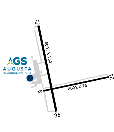
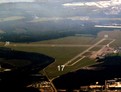
| Lat: N 3322.2 Long: W 08157.9 Elev: 146 Var: +04 Longest Runway: 8001 | ||
| Clr Del: 118.65 Dept. ATIS: 132.75 Arr. ATIS: 132.75 Ground: 121.9 Tower: 118.7 | ||
| ||||||||||||||||||||||||||||||||||||||||||||||||||||||||||||||||||||
| ||||||||||||||||||||||||||||||||||||||||||||||||||||||||||||||||||||
| ||||||||||||||||||||||||||||||||||||||||||||||||||||||||||||||||||||
| Rwy | Rwy | |||||||
| 6002x75 | 6002' | 6002x75 | 6002' | |||||
| 8001x150 | 8001' | 111.75 - 172° | 8001x150 | 8001' | 110.50 - 352° | |||
| Runway ID | Single Wheel | Double Wheel | Double Tandem Wheel | Dual Double Wheel |
| 08/26 | 52,000 | 71,000 | 126,000 | N/A |
| 17/35 | 155,000 | 160,000 | 450,000 | 975,000 |
| These numbers are Advisory and are not limits. The Airport Manager should have more accurate Weight Limits | ||||
 Airport Diagram might not be current. | |
| Facility Name: | AUGUSTA RGNL AT BUSH FLD |
| City Name: | AUGUSTA |
| County: | RICHMOND |
| State abbrev: | GA |
| State Name: | GEORGIA |
| Ownership: | PUBLICLY OWNED |
| Use: | OPEN TO THE PUBLIC |
| Owner's Name: | CITY OF AUGUSTA |
| Address: | AVIATION DEPARTMENT, 1501 AVIATION WAY |
| AUGUSTA, GA 30906 | |
| Owner's Phone: | 706-798-2656 |
| Manager's Name: | HERBERT JUDON |
| Address: | 1501 AVIATION WAY |
| AUGUSTA, GA 30906 | |
| Phone: | 706-798-3236 |
| FAA Region: | SOUTHERN |
| FAA Field Office: | ATL |
| Date | Sunrise | Sunset |
|---|---|---|
| 09/24/21 Friday | 7:17 | 19:22 |
| 09/25/21 Saturday | 7:18 | 19:21 |
| 09/26/21 Sunday | 7:18 | 19:19 |
| 09/27/21 Monday | 7:19 | 19:18 |
| 09/28/21 Tuesday | 7:20 | 19:17 |
| 09/29/21 Wednesday | 7:21 | 19:15 |
| 09/30/21 Thursday | 7:21 | 19:14 |
| 10/01/21 Friday | 7:22 | 19:13 |
| 10/02/21 Saturday | 7:23 | 19:11 |
| 10/03/21 Sunday | 7:23 | 19:10 |
| 10/04/21 Monday | 7:24 | 19:09 |
| 10/05/21 Tuesday | 7:25 | 19:07 |
| 10/06/21 Wednesday | 7:26 | 19:06 |
| 10/07/21 Thursday | 7:26 | 19:05 |
| Airport Attendance Schedule | CONTINUOUS |
| Airport Status | OPERATIONAL (This Status can change at any time - please check NOTAMS) |
| Airport Lighting Schedule | PAPI RYS 08, 17, 26 & 35, OPER CONT. REIL RYS 8 AND 26, MIRL RY 08/26, AND HIRL RY 17/35 OPER CONT WHEN ATCT CLSD. ACTVT MALSR RYS 17 AND 35 - CTAF. |
| Airport Storage Available | Tie Downs, Hanger |
| Extra Services Available | Air Ambulance, Avionics, Cargo Handling, Charter, Aircraft Rental, Aircraft Sales |
| Wind Indicator | YES - (unlit) |
| Control Tower | YES |
| CTAF Frequency | 118.700 |
| Unicom Frequency | 122.950 |
| Rotating Beacon Color | CLEAR-GREEN (Light Land Airport) |
| Segmented Circle | YES |
| Landing Fee | NO |
| Airport Inspected | FEDERAL - performed by FAA AIRPORTS FIELD PERSONNEL |
| Inspection Date | 07/23/2021 |
| Type of Fuel Available | Grade 100LL, JET A (freeze point -40C) |
| Airframe Repair Service | MAJOR |
| Power Plant Repair Service | MAJOR |
| Latitude | N3322.2 |
| Longitude | W08157.9 (ESTIMATED) |
| Arpt Elevation | 145ft (SURVEYED) |
| Magnetic Variation | 04W |
| 6 miles S | of AUGUSTA |
| Traffic Pattern Altitude | |
| Sectional Chart | ATLANTA |
| Operations (Reported) | Yearly | Avg. Daily |
|---|---|---|
| General Aviation Transient | 8865 | 24 |
| General Aviation Local | 4120 | 11 |
| Air Taxi | 5926 | 16 |
| Commerical | 4850 | 13 |
| Commuter | 0 | 0 |
| Military | 4099 | 11 |
| Aircraft based on Field | |
|---|---|
| General Aviation Singles | 5 |
| General Aviation Multi | 7 |
| Jet Aircraft | 4 |
| General Aviation Helicopters | 2 |
| Military Aircraft | 0 |
| Gliders | 0 |
| Ultralights | 0 |
| FSS on field | NO |
| FSS tie-in | MACON |
| FSS Phone | 1-800-WX-BRIEF |
| Who issues Notams | AGS |
| Notam D service at airport | YES |
| ARTCC Name | ATLANTA |
| Airport Certification | AIRPORT RECEIVING SCHEDULED AIR CARRIER SERVICE FROM CARRIERS CERTIFICATED BY THE CIVIL AERONAUTICS BOARD; ARFF INDEX C AVBL UPON REQUEST. |
| Aircraft Rescue & Firefighting Index | AIRPORT HAS A CERTIFICATE UNDER CFR PART 139 |
| Airport of Entry | No |
| Custom Landing Rights | No |
| Joint Civil/Military | No |
| Military Landing rights | YES |
| NATIONAL PLAN OF INTEGRATED AIRPORT SYSTEMS (NPIAS) |
| GRANT AGREEMENTS UNDER FAAP/ADAP/AIP |
| SURPLUS PROPERTY AGREEMENT UNDER PUBLIC LAW 289 |
| ASSURANCES PURSUANT TO TITLE VI, CIVIL RIGHTS ACT OF 1964 |
| BIRDS ON & INVOF ARPT. HVY BIRD ACT INVOF ARPT NOV-MAR. |
| CAUTION: TAXI-LANE RAMP ENTRANCE/EXIT POINT INTO STANDARD AERO STORM WATER DITCH ON NORTH SIDE. |
| CAUTION: WILDLIFE HAZARD COYOTE. |
| FOR CD IF UNA TO CTC ON FSS FREQ, CTC AUGUSTA APCH AT 706-771-1777, WHEN APCH CLSD CTC ATLANTA ARTCC AT 770-210-7692. |
| TWY ALL EAST OF RWY 17/35 CLSD TO AIR CARRIER ACFT. |
| RWY 08/2 6 RWY 8/26 NOT AVBL FOR SKED ACR OPNS WITH MORE THAN 9 PSGR SEATS OR UNSKED ACR AT LEAST 31 PSGR SEATS. |
| RWY 17/3 5 2S-175 |
| RWY 17/3 5 2T-585K (B-C-17), 2D/2D2-975K (747), 840K (C-5) 2D/2D2-975K (747) |
Airport Communications & Frequencies:
| |||||||||||||||||||||||||||||||||||||||||
| Runway: 08 | Runway: 26 | ||
| Mag heading: | 82° | Mag heading: | 262° |
| Rwy Slope: | .06% Up | Rwy Slope: | -.06% Down |
| Approach: | Approach: | ||
| Pattern: | Left Traffic | Pattern: | Left Traffic |
| Markings: | NONPRECISION INSTRUMENT | Markings: | NONPRECISION INSTRUMENT |
| Marking Condition: | GOOD | Marking Condition: | GOOD |
| Arresting Dev: | Arresting Dev: | ||
| Lat & Long: | N3322.0 W08158.2 | Lat. & Long.: | N3322.2 W08157.0 |
| Elev: | 133.7 ft. MSL | Elev: | 137.5 ft. MSL |
| TCH: | 64 ft. AGL | TCH: | 64 ft. AGL |
| Visual Glide Path: | 3.00 degrees | Visual Glide Path: | 3.00 degrees |
| Displaced Threshold: | No | Displaced Threshold: | No |
| Touchdown Zone: | YES | Touchdown Zone: | YES |
| Touchdown Elev.: | 136.7 feet | Touchdown Elev.: | 138.7 feet |
| Visual Glide Slope: | 4-Light PAPI on LEFT side of Runway | Visual Glide Slope: | 4-Light PAPI on LEFT side of Runway |
| RVR Equipment: | RVR Equipment: | ||
| RVV Equipment: | NO | RVV Equipment: | NO |
| Approach Lights: | Approach Lights: | ||
| REIL: | YES | REIL: | YES |
| Centerline Lights: | NO | Centerline Lights: | NO |
| Touchdown lights: | NO | Touchdown lights: | NO |
| Runway Category: | Runway with a Non-precision Approach having visibility minimums greater than 3/4 mile | Runway Category: | Runway with a Non-precision Approach having visibility minimums greater than 3/4 mile |
| Declared Distances: | Declared Distances: | ||
| Obstructions: | TREES | Obstructions: | TREES |
| Marked: | NOT Marked/Lighted | Marked: | NOT Marked/Lighted |
| Clearance slope: | 20:1 | Clearance slope: | 16:1 |
| Obstruction height: | 52 feet AGL | Obstruction height: | 65 feet AGL |
| Dist. from runway: | 1250 feet | Dist. from runway: | 1250 feet |
| Centerline offset: | 125 right of centerline | Centerline offset: | 200 feet left of centerline |
| Comments: | Comments: |
| Runway: 17 | Runway: 35 | ||
| Mag heading: | 172° | Mag heading: | 352° |
| Rwy Slope: | -.14% Down | Rwy Slope: | .14% Up |
| Approach: | ILS | Approach: | ILS |
| Pattern: | Left Traffic | Pattern: | Left Traffic |
| Markings: | PRECISION INSTRUMENT | Markings: | PRECISION INSTRUMENT |
| Marking Condition: | GOOD | Marking Condition: | GOOD |
| Arresting Dev: | Arresting Dev: | ||
| Lat & Long: | N3322.9 W08158.3 | Lat. & Long.: | N3321.7 W08157.9 |
| Elev: | 144.8 ft. MSL | Elev: | 133.7 ft. MSL |
| TCH: | 71 ft. AGL | TCH: | 72 ft. AGL |
| Visual Glide Path: | 3.00 degrees | Visual Glide Path: | 3.00 degrees |
| Displaced Threshold: | No | Displaced Threshold: | No |
| Touchdown Zone: | YES | Touchdown Zone: | YES |
| Touchdown Elev.: | 145.7 feet | Touchdown Elev.: | 137.0 feet |
| Visual Glide Slope: | 4-Light PAPI on LEFT side of Runway | Visual Glide Slope: | 4-Light PAPI on LEFT side of Runway |
| RVR Equipment: | TOUCHDOWN-ROLLOUT | RVR Equipment: | TOUCHDOWN-ROLLOUT |
| RVV Equipment: | NO | RVV Equipment: | NO |
| Approach Lights: | MALSR - 1,400 foot medium intensity approach lighting system with runway alignment indicator lights | Approach Lights: | MALSR - 1,400 foot medium intensity approach lighting system with runway alignment indicator lights |
| REIL: | NO | REIL: | NO |
| Centerline Lights: | NO | Centerline Lights: | NO |
| Touchdown lights: | NO | Touchdown lights: | NO |
| Runway Category: | Precision Instrument Runway | Runway Category: | Precision Instrument Runway |
| Declared Distances: | Declared Distances: | ||
| Obstructions: | TREE | Obstructions: | TREES |
| Marked: | NOT Marked/Lighted | Marked: | NOT Marked/Lighted |
| Clearance slope: | 38:1 | Clearance slope: | 21:1; PER SURVEY DECEMBER 2004 RWY 17-35 |
| Obstruction height: | 90 feet AGL | Obstruction height: | 42 feet AGL |
| Dist. from runway: | 2450 feet | Dist. from runway: | 1500 feet |
| Centerline offset: | 800 left of centerline | Centerline offset: | 600 feet left of centerline |
| Comments: | Comments: |
Thanks for using FltPlan.com
all rights reserved © 1999-2021 by Flight Plan LLC


