| ALLEGHENY COUNTY PITTSBURGH PA |
| |
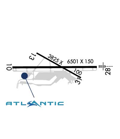
| Lat: N 4021.3 Long: W 07955.7 Elev: 1252 Var: +09 Longest Runway: 6501 | ||
| Dept. ATIS: 120.55 Arr. ATIS: 120.55 Ground: 121.7 Tower: 121.1 | ||
| ||||||||||||||||||||||||||||||||||||||||||||||||||||||||||||||||||||
| ||||||||||||||||||||||||||||||||||||||||||||||||||||||||||||||||||||
| ||||||||||||||||||||||||||||||||||||||||||||||||||||||||||||||||||||
| ||||||||||||||||||||||||||||||||||||||||||||||||||||||||||||||||||||
| FBOs at nearby airports who want your business: | |||||||||||
| |||||||||||
| Rwy | Rwy | |||||||
| 6501x150 | 6501' | 109.10 - 099° | 6501x150 | 6501' | 109.10 - 280° | |||
| 3825x100 | 3825' | 3825x100 | 3825' | |||||
| Runway ID | Single Wheel | Double Wheel | Double Tandem Wheel | Dual Double Wheel |
| 10/28 | 90,000 | 120,000 | 210,000 | N/A |
| 13/31 | 20,000 | 22,000 | N/A | N/A |
| H1 | N/A | N/A | N/A | N/A |
| These numbers are Advisory and are not limits. The Airport Manager should have more accurate Weight Limits | ||||
 Airport Diagram might not be current. | |
| Facility Name: | ALLEGHENY COUNTY |
| City Name: | PITTSBURGH |
| County: | ALLEGHENY |
| State abbrev: | PA |
| State Name: | PENNSYLVANIA |
| Ownership: | PUBLICLY OWNED |
| Use: | OPEN TO THE PUBLIC |
| Owner's Name: | ALLEGHENY CO ARPT AUTHORITY |
| Address: | PO BOX 12370 |
| PITTSBURGH, PA 15231-0370 | |
| Owner's Phone: | 412-472-3500 |
| Manager's Name: | LANCE BAGNOFF |
| Address: | 12 ALLEGHENY COUNTY AIRPORT |
| WEST MIFFLIN, PA 15122-2656 | |
| Phone: | 412-472-5839 |
| FAA Region: | EASTERN |
| FAA Field Office: | HAR |
| Date | Sunrise | Sunset |
|---|---|---|
| 05/24/25 Saturday | 5:56 | 20:37 |
| 05/25/25 Sunday | 5:56 | 20:38 |
| 05/26/25 Monday | 5:55 | 20:39 |
| 05/27/25 Tuesday | 5:54 | 20:40 |
| 05/28/25 Wednesday | 5:54 | 20:40 |
| 05/29/25 Thursday | 5:53 | 20:41 |
| 05/30/25 Friday | 5:53 | 20:42 |
| 05/31/25 Saturday | 5:52 | 20:43 |
| 06/01/25 Sunday | 5:52 | 20:43 |
| 06/02/25 Monday | 5:52 | 20:44 |
| 06/03/25 Tuesday | 5:51 | 20:45 |
| 06/04/25 Wednesday | 5:51 | 20:45 |
| 06/05/25 Thursday | 5:50 | 20:46 |
| 06/06/25 Friday | 5:50 | 20:47 |
| Airport Attendance Schedule | CONTINUOUS |
| Airport Status | OPERATIONAL (This Status can change at any time - please check NOTAMS) |
| Airport Lighting Schedule | ATC-CTL. |
| Airport Storage Available | Tie Downs, Hanger |
| Extra Services Available | Air Freight, Air Ambulance, Avionics, Cargo Handling, Charter, Flight Instruction |
| Wind Indicator | YES - (lighted) |
| Control Tower | YES |
| CTAF Frequency | |
| Unicom Frequency | 122.950 |
| Rotating Beacon Color | WG |
| Segmented Circle | NO |
| Landing Fee | YES; LNDG FEE FOR ACFT 5000 LBS & ABV TO INCL ALL HELS. |
| Airport Inspected | FEDERAL - performed by STATE AERONAUTICAL PERSONNEL |
| Inspection Date | 12/17/2024 |
| Type of Fuel Available | Grade 100LL, JET A (freeze point -40C), JET A; -A+JET A ANTI-ICE AVBL ON REQ. |
| Airframe Repair Service | MAJOR |
| Power Plant Repair Service | MAJOR |
| Latitude | N4021.3 |
| Longitude | W07955.7 (ESTIMATED) |
| Arpt Elevation | 1251ft (SURVEYED) |
| Magnetic Variation | 09W |
| 4 miles SE | of PITTSBURGH |
| Traffic Pattern Altitude | |
| Sectional Chart | DETROIT |
| Operations (Reported) | Yearly | Avg. Daily |
|---|---|---|
| General Aviation Transient | 0 | 0 |
| General Aviation Local | 0 | 0 |
| Air Taxi | 0 | 0 |
| Commerical | 0 | 0 |
| Commuter | 0 | 0 |
| Military | 0 | 0 |
| Aircraft based on Field | |
|---|---|
| General Aviation Singles | 0 |
| General Aviation Multi | 0 |
| Jet Aircraft | 0 |
| General Aviation Helicopters | 0 |
| Military Aircraft | 0 |
| Gliders | 0 |
| Ultralights | 0 |
| FSS on field | NO |
| FSS tie-in | ALTOONA |
| FSS Phone | 1-800-WX-BRIEF |
| Who issues Notams | AGC |
| Notam D service at airport | YES |
| ARTCC Name | CLEVELAND |
| Airport Certification | |
| Aircraft Rescue & Firefighting Index | None |
| Airport of Entry | No |
| Custom Landing Rights | No |
| Joint Civil/Military | No |
| Military Landing rights | YES |
| NATIONAL PLAN OF INTEGRATED AIRPORT SYSTEMS (NPIAS) |
| GRANT AGREEMENTS UNDER FAAP/ADAP/AIP |
| ASSURANCES PURSUANT TO TITLE VI, CIVIL RIGHTS ACT OF 1964 |
| BIRDS & DEER ON & INVOF ARPT. |
| APN MAIN TRML RAMP PRKG 12HR PPR 412-759-7897. |
| RWY H1 HELIPAD LCTD ON GA APN E OF TWY C. |
Airport Communications & Frequencies:
| ||||||||||||||||||||||||||||||
| Runway: 10 | Runway: 28 | ||
| Mag heading: | 99° | Mag heading: | 279° |
| Rwy Slope: | .01% Up | Rwy Slope: | -.01% Down |
| Approach: | ILS | Approach: | ILS |
| Pattern: | Left Traffic | Pattern: | Left Traffic |
| Markings: | PRECISION INSTRUMENT | Markings: | PRECISION INSTRUMENT |
| Marking Condition: | GOOD | Marking Condition: | GOOD |
| Arresting Dev: | Arresting Dev: | ||
| Lat & Long: | N4021.3 W07956.5 | Lat. & Long.: | N4021.3 W07955.1 |
| Elev: | 1249.4 ft. MSL | Elev: | 1250.0 ft. MSL |
| TCH: | 47 ft. AGL | TCH: | |
| Visual Glide Path: | 3.00 degrees | Visual Glide Path: | |
| Displaced Threshold: | No | Displaced Threshold: | No |
| Touchdown Zone: | YES | Touchdown Zone: | YES |
| Touchdown Elev.: | 1251.3 feet | Touchdown Elev.: | 1251.3 feet |
| Visual Glide Slope: | 4-BOX VASI ON LEFT SIDE OF RUNWAY | Visual Glide Slope: | |
| RVR Equipment: | ROLLOUT | RVR Equipment: | TOUCHDOWN |
| RVV Equipment: | NO | RVV Equipment: | NO |
| Approach Lights: | Approach Lights: | MALS - 1,400 foot medium intensity approach lighting system | |
| REIL: | YES | REIL: | NO |
| Centerline Lights: | NO | Centerline Lights: | NO |
| Touchdown lights: | NO | Touchdown lights: | NO |
| Runway Category: | Precision Instrument Runway | Runway Category: | Precision Instrument Runway |
| Declared Distances: | Declared Distances: | ||
| Obstructions: | Obstructions: | TREES | |
| Marked: | Marked: | NOT Marked/Lighted | |
| Clearance slope: | 50:1 | Clearance slope: | 38:1 |
| Obstruction height: | Obstruction height: | 63 feet AGL | |
| Dist. from runway: | Dist. from runway: | 2613 feet | |
| Centerline offset: | Centerline offset: | 433 feet left of centerline | |
| Comments: | Comments: |
| Runway: 13 | Runway: 31 | ||
| Mag heading: | 129° | Mag heading: | 309° |
| Rwy Slope: | .09% Up | Rwy Slope: | -.09% Down |
| Approach: | Approach: | ||
| Pattern: | Left Traffic | Pattern: | Left Traffic |
| Markings: | BASIC | Markings: | BASIC |
| Marking Condition: | GOOD | Marking Condition: | GOOD |
| Arresting Dev: | Arresting Dev: | ||
| Lat & Long: | N4021.4 W07956.1 | Lat. & Long.: | N4021.1 W07955.3 |
| Elev: | 1245.2 ft. MSL | Elev: | 1248.6 ft. MSL |
| TCH: | TCH: | ||
| Visual Glide Path: | Visual Glide Path: | ||
| Displaced Threshold: | No | Displaced Threshold: | No |
| Touchdown Zone: | YES | Touchdown Zone: | YES |
| Touchdown Elev.: | 1251.5 feet | Touchdown Elev.: | 1251.5 feet |
| Visual Glide Slope: | Visual Glide Slope: | ||
| RVR Equipment: | RVR Equipment: | ||
| RVV Equipment: | NO | RVV Equipment: | NO |
| Approach Lights: | Approach Lights: | ||
| REIL: | YES | REIL: | YES |
| Centerline Lights: | NO | Centerline Lights: | NO |
| Touchdown lights: | NO | Touchdown lights: | NO |
| Runway Category: | Runway with a Visual Approach | Runway Category: | Runway with a Visual Approach |
| Declared Distances: | Declared Distances: |
Thanks for using FltPlan.com
all rights reserved © 1999-2025 by Flight Plan LLC