
| HUNTINGTON MUNI HUNTINGTON UT |
| |
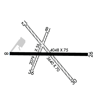
| Lat: N 3921.7 Long: W 11055.0 Elev: 5915 Var: -14 Longest Runway: 4048 | ||
| CTAF: 122.8 | ||
| ||||||
|
| Rwy | Rwy | |||||||
| 4048x75 | 3834' | 4048x75 | 4048' | |||||
| 3640x70 | 3640' | 3640x70 | 3640' | |||||
| 2079x56 | 2079' | 2079x56 | 2079' | |||||
| Runway ID | Single Wheel | Double Wheel | Double Tandem Wheel | Dual Double Wheel |
| 08/26 | 12,500 | N/A | N/A | N/A |
| 12/30 | 6,000 | N/A | N/A | N/A |
| 18/36 | N/A | N/A | N/A | N/A |
| These numbers are Advisory and are not limits. The Airport Manager should have more accurate Weight Limits | ||||
 Airport Diagram might not be current. | |
| Facility Name: | HUNTINGTON MUNI |
| City Name: | HUNTINGTON |
| County: | EMERY |
| State abbrev: | UT |
| State Name: | UTAH |
| Ownership: | PUBLICLY OWNED |
| Use: | OPEN TO THE PUBLIC |
| Owner's Name: | EMERY COUNTY |
| Address: | 75 EAST MAIN, PO BOX 629 |
| CASTLE DALE, UT 84513 | |
| Owner's Phone: | 435-381-2119 |
| Manager's Name: | JEFF GUYMON |
| Address: | 75 E MAIN ST. PO BOX 907, 95 EAST MAIN |
| CASTLE DALE, UT 84513 | |
| Phone: | (435) 381-3589 |
| FAA Region: | NORTHWEST MOUNTAIN |
| FAA Field Office: | DEN |
| Date | Sunrise | Sunset |
|---|---|---|
| 09/24/21 Friday | 7:13 | 19:18 |
| 09/25/21 Saturday | 7:14 | 19:16 |
| 09/26/21 Sunday | 7:15 | 19:14 |
| 09/27/21 Monday | 7:16 | 19:13 |
| 09/28/21 Tuesday | 7:17 | 19:11 |
| 09/29/21 Wednesday | 7:18 | 19:10 |
| 09/30/21 Thursday | 7:19 | 19:08 |
| 10/01/21 Friday | 7:20 | 19:06 |
| 10/02/21 Saturday | 7:21 | 19:05 |
| 10/03/21 Sunday | 7:21 | 19:03 |
| 10/04/21 Monday | 7:22 | 19:02 |
| 10/05/21 Tuesday | 7:23 | 19:00 |
| 10/06/21 Wednesday | 7:24 | 18:59 |
| 10/07/21 Thursday | 7:25 | 18:57 |
| Airport Attendance Schedule | UNATTENDED |
| Airport Status | OPERATIONAL (This Status can change at any time - please check NOTAMS) |
| Airport Lighting Schedule | ACTVT MIRL RY 08/26 - CTAF. |
| Airport Storage Available | Tie Downs |
| Extra Services Available | Flight Instruction |
| Wind Indicator | YES - (lighted) |
| Control Tower | NO |
| CTAF Frequency | 122.800; LCL WX AVBL CTAF 122.8 , 3 CLICKS. |
| Unicom Frequency | 122.800 |
| Rotating Beacon Color | CLEAR-GREEN (Light Land Airport) |
| Segmented Circle | YES |
| Landing Fee | NO |
| Airport Inspected | STATE - performed by STATE AERONAUTICAL PERSONNEL |
| Inspection Date | 07/11/2018 |
| Type of Fuel Available | Grade 100LL; -1024 HR CREDIT CARD SVC AVBL. |
| Airframe Repair Service | NONE |
| Power Plant Repair Service | NONE |
| Latitude | N3921.7 |
| Longitude | W11055.0 (ESTIMATED) |
| Arpt Elevation | 5915ft (ESTIMATED) |
| Magnetic Variation | 14E |
| 3 miles NE | of HUNTINGTON |
| Traffic Pattern Altitude | |
| Sectional Chart | DENVER |
| Operations (Reported) | Yearly | Avg. Daily |
|---|---|---|
| General Aviation Transient | 2958 | 8 |
| General Aviation Local | 742 | 2 |
| Air Taxi | 10 | 0 |
| Commerical | 0 | 0 |
| Commuter | 0 | 0 |
| Military | 0 | 0 |
| Aircraft based on Field | |
|---|---|
| General Aviation Singles | 4 |
| General Aviation Multi | 0 |
| Jet Aircraft | 0 |
| General Aviation Helicopters | 1 |
| Military Aircraft | 0 |
| Gliders | 0 |
| Ultralights | 0 |
| FSS on field | NO |
| FSS tie-in | CEDAR CITY |
| FSS Phone | 1-800-WX-BRIEF |
| Who issues Notams | CDC |
| Notam D service at airport | YES |
| ARTCC Name | SALT LAKE CITY |
| Airport Certification | |
| Aircraft Rescue & Firefighting Index | None |
| Airport of Entry | No |
| Custom Landing Rights | No |
| Joint Civil/Military | No |
| Military Landing rights | YES |
| RY 08/26 NO LINE OF SIGHT BTN RY ENDS. |
| FOR CD CTC SALT LAKE ARTCC AT 801-320-2568. |
| RWY 12/3 0 SMALL AMOUNTS OF VEGETATION ON RUNWAY 12/30. |
| RWY 18/3 6 SMALL AMOUNTS OF VEGETATION ON RUNWAY 18/36. |
Airport Communications & Frequencies:
| |||||||||
| Runway: 08 | Runway: 26 | ||
| Mag heading: | 76° | Mag heading: | 256° |
| Rwy Slope: | -.78% Down | Rwy Slope: | .78% Up |
| Approach: | Approach: | ||
| Pattern: | Left Traffic | Pattern: | Left Traffic |
| Markings: | NONPRECISION INSTRUMENT | Markings: | NONPRECISION INSTRUMENT |
| Marking Condition: | GOOD | Marking Condition: | GOOD |
| Arresting Dev: | Arresting Dev: | ||
| Lat & Long: | N3921.7 W11055.4 | Lat. & Long.: | N3921.7 W11054.6 |
| Elev: | 5903.0 ft. MSL | Elev: | 5871.5 ft. MSL |
| TCH: | TCH: | ||
| Visual Glide Path: | Visual Glide Path: | ||
| Displaced Threshold: | 214 feet | Displaced Threshold: | No |
| Touchdown Zone: | NO | Touchdown Zone: | NO |
| Touchdown Elev.: | Touchdown Elev.: | ||
| Visual Glide Slope: | Visual Glide Slope: | ||
| RVR Equipment: | RVR Equipment: | ||
| RVV Equipment: | NO | RVV Equipment: | NO |
| Approach Lights: | Approach Lights: | ||
| REIL: | NO | REIL: | NO |
| Centerline Lights: | NO | Centerline Lights: | NO |
| Touchdown lights: | NO | Touchdown lights: | NO |
| Runway Category: | Runway with a Non-precision Approach | Runway Category: | Runway with a Non-precision Approach |
| Declared Distances: | Declared Distances: | ||
| Obstructions: | Obstructions: | ROAD | |
| Marked: | Marked: | NOT Marked/Lighted | |
| Clearance slope: | 34:1 | Clearance slope: | 7:1 |
| Obstruction height: | Obstruction height: | 13 feet AGL | |
| Dist. from runway: | Dist. from runway: | 300 feet | |
| Centerline offset: | Centerline offset: | 217 feet right of centerline | |
| Comments: | Comments: |
| Runway: 12 | Runway: 30 | ||
| Mag heading: | 126° | Mag heading: | 306° |
| Rwy Slope: | -1.16% Down | Rwy Slope: | 1.16% Up |
| Approach: | Approach: | ||
| Pattern: | Left Traffic | Pattern: | Left Traffic |
| Markings: | Markings: | ||
| Marking Condition: | Marking Condition: | ||
| Arresting Dev: | Arresting Dev: | ||
| Lat & Long: | N3921.9 W11055.2 | Lat. & Long.: | N3921.4 W11054.7 |
| Elev: | 5915.0 ft. MSL | Elev: | 5872.7 ft. MSL |
| TCH: | TCH: | ||
| Visual Glide Path: | Visual Glide Path: | ||
| Displaced Threshold: | No | Displaced Threshold: | No |
| Touchdown Zone: | NO | Touchdown Zone: | NO |
| Touchdown Elev.: | Touchdown Elev.: | ||
| Visual Glide Slope: | Visual Glide Slope: | ||
| RVR Equipment: | RVR Equipment: | ||
| RVV Equipment: | NO | RVV Equipment: | NO |
| Approach Lights: | Approach Lights: | ||
| REIL: | NO | REIL: | NO |
| Centerline Lights: | NO | Centerline Lights: | NO |
| Touchdown lights: | NO | Touchdown lights: | NO |
| Runway Category: | Runway with a Visual Approach | Runway Category: | Runway with a Visual Approach |
| Declared Distances: | Declared Distances: | ||
| Obstructions: | FENCE; MARKED PLINE 360' FROM END RWY. | Obstructions: | ROAD |
| Marked: | NOT Marked/Lighted | Marked: | NOT Marked/Lighted |
| Clearance slope: | 8:1 | Clearance slope: | 5:1 |
| Obstruction height: | 13 feet AGL | Obstruction height: | 20 feet AGL |
| Dist. from runway: | 110 feet | Dist. from runway: | 100 feet |
| Centerline offset: | Centerline offset: | ||
| Comments: | Comments: |
| Runway: 18 | Runway: 36 | ||
| Mag heading: | 189° | Mag heading: | 9° |
| Rwy Slope: | -.65% Down | Rwy Slope: | .65% Up |
| Approach: | Approach: | ||
| Pattern: | Left Traffic | Pattern: | Left Traffic |
| Markings: | Markings: | ||
| Marking Condition: | Marking Condition: | ||
| Arresting Dev: | Arresting Dev: | ||
| Lat & Long: | N3921.8 W11055.0 | Lat. & Long.: | N3921.5 W11055.2 |
| Elev: | 5901.6 ft. MSL | Elev: | 5888.1 ft. MSL |
| TCH: | TCH: | ||
| Visual Glide Path: | Visual Glide Path: | ||
| Displaced Threshold: | No | Displaced Threshold: | No |
| Touchdown Zone: | NO | Touchdown Zone: | NO |
| Touchdown Elev.: | Touchdown Elev.: | ||
| Visual Glide Slope: | Visual Glide Slope: | ||
| RVR Equipment: | RVR Equipment: | ||
| RVV Equipment: | NO | RVV Equipment: | NO |
| Approach Lights: | Approach Lights: | ||
| REIL: | NO | REIL: | NO |
| Centerline Lights: | NO | Centerline Lights: | NO |
| Touchdown lights: | NO | Touchdown lights: | NO |
| Runway Category: | Runway with a Visual Approach | Runway Category: | Runway with a Visual Approach |
| Declared Distances: | Declared Distances: |
Thanks for using FltPlan.com
all rights reserved © 1999-2021 by Flight Plan LLC
