
| BOERNE STAGE FIELD SAN ANTONIO TX |
| |
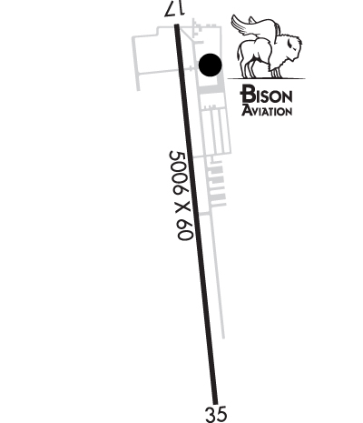
| Lat: N 2943.4 Long: W 09841.7 Elev: 1384 Var: -05 Longest Runway: 5006 | ||
| AWOS: 118.72 CTAF: 123.0 | ||
| ||||||||||||||||||||||||||||||||||||||||||||
| ||||||||||||||||||||||||||||||||||||||||||||
| ||||||||||||||||||||||||||||||||||||||||||||
| ||||||||||||||||||||||||||||||||||||||||||||
| Rwy | Rwy | |||||||
| 5006x60 | 4377' | 5006x60 | 3920' | |||||
| Runway ID | Single Wheel | Double Wheel | Double Tandem Wheel | Dual Double Wheel |
| 17/35 | N/A | N/A | N/A | N/A |
| These numbers are Advisory and are not limits. The Airport Manager should have more accurate Weight Limits | ||||
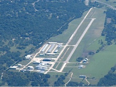
 Airport Diagram might not be current. | |
| Facility Name: | BOERNE STAGE AIRFIELD |
| City Name: | SAN ANTONIO |
| County: | BEXAR |
| State abbrev: | TX |
| State Name: | TEXAS |
| Ownership: | PRIVATELY OWNED |
| Use: | OPEN TO THE PUBLIC |
| Owner's Name: | BOERNE STAGE AIRFIELD, INC |
| Address: | 400 BOERNE STAGE AIRFIELD |
| BOERNE, TX 78006 | |
| Owner's Phone: | 830-981-2345 |
| Manager's Name: | KELBY COMBS |
| Address: | 400 BOERNE STAGE AIRFIELD |
| BOERNE, TX 78006 | |
| Phone: | 337-258-8387; 5C1.KELBY@GMAIL.COM |
| FAA Region: | SOUTHWEST |
| FAA Field Office: | TEX |
| Date | Sunrise | Sunset |
|---|---|---|
| 06/17/26 Wednesday | 6:34 | 20:37 |
| 06/18/26 Thursday | 6:34 | 20:38 |
| 06/19/26 Friday | 6:34 | 20:38 |
| 06/20/26 Saturday | 6:35 | 20:38 |
| 06/21/26 Sunday | 6:35 | 20:38 |
| 06/22/26 Monday | 6:35 | 20:38 |
| 06/23/26 Tuesday | 6:35 | 20:39 |
| 06/24/26 Wednesday | 6:36 | 20:39 |
| 06/25/26 Thursday | 6:36 | 20:39 |
| 06/26/26 Friday | 6:36 | 20:39 |
| 06/27/26 Saturday | 6:36 | 20:39 |
| 06/28/26 Sunday | 6:37 | 20:39 |
| 06/29/26 Monday | 6:37 | 20:39 |
| 06/30/26 Tuesday | 6:37 | 20:39 |
| Airport Attendance Schedule | 7 Days A Week 0800-1700 |
| Airport Status | OPERATIONAL (This Status can change at any time - please check NOTAMS) |
| Airport Lighting Schedule | SS-SR |
| Airport Storage Available | Tie Downs, Hanger |
| Extra Services Available | Glider, Flight Instruction, Aircraft Rental, Glider Towing |
| Wind Indicator | YES - (lighted) |
| Control Tower | NO |
| CTAF Frequency | 123.000 |
| Unicom Frequency | 123.000; UNICOM UNMNT. |
| Rotating Beacon Color | WG |
| Segmented Circle | YES |
| Landing Fee |
| Airport Inspected | STATE - performed by PRIVATE CONTRACT PERSONNEL |
| Inspection Date | 11/13/2025 |
| Type of Fuel Available | Grade 100LL, JET A (freeze point -40C) |
| Airframe Repair Service | MAJOR |
| Power Plant Repair Service | MAJOR |
| Latitude | N2943.4 |
| Longitude | W09841.7 (ESTIMATED) |
| Arpt Elevation | 1383ft (SURVEYED) |
| Magnetic Variation | 05E |
| 20 miles NW | of SAN ANTONIO |
| Traffic Pattern Altitude | |
| Sectional Chart | SAN ANTONIO |
| Operations (Reported) | Yearly | Avg. Daily |
|---|---|---|
| General Aviation Transient | 0 | 0 |
| General Aviation Local | 0 | 0 |
| Air Taxi | 0 | 0 |
| Commerical | 0 | 0 |
| Commuter | 0 | 0 |
| Military | 0 | 0 |
| Aircraft based on Field | |
|---|---|
| General Aviation Singles | 0 |
| General Aviation Multi | 0 |
| Jet Aircraft | 0 |
| General Aviation Helicopters | 0 |
| Military Aircraft | 0 |
| Gliders | 0 |
| Ultralights | 0 |
| FSS on field | NO |
| FSS tie-in | SAN ANGELO |
| FSS Phone | 1-800-WX-BRIEF |
| Who issues Notams | SJT |
| Notam D service at airport | YES |
| ARTCC Name | HOUSTON |
| Airport Certification | |
| Aircraft Rescue & Firefighting Index | None |
| Airport of Entry | No |
| Custom Landing Rights | No |
| Joint Civil/Military | No |
| Military Landing rights | No |
| NOISE ABATEMENT PROCEDURES IN EFFECT CTC AMGR. |
| USE EXTREME CTN WHEN OPRG INTO AND OUT OF 5C1 FOR OVER FLIGHT TFC LDG SAN ANTONIO INTL (KSAT) AT 3000 FT MSL AND ABV. SEE LTA-SAT-32. |
| LANDING FEES IN EFFECT |
| NO TGLS, STOP & GO OR LOW APCHS. |
| GLIDER ACT ON & INVOF ARPT. |
| ALL LNDG TURBINE ACFT MUST BE STAGE 3 OR BETTER. |
| RWY 35, 35 FT LGTD PWR POLES ACRS APCH. |
| FOR CD CTC SAN ANTONIO APCH AT 210-805-5516. |
Airport Communications & Frequencies:
| ||||||||||||||
| Runway: 17 | Runway: 35 | ||
| Mag heading: | 169° | Mag heading: | 349° |
| Rwy Slope: | -.12% Down | Rwy Slope: | .12% Up |
| Approach: | Approach: | ||
| Pattern: | Right Traffic | Pattern: | Left Traffic |
| Markings: | NONPRECISION INSTRUMENT | Markings: | NONPRECISION INSTRUMENT |
| Marking Condition: | GOOD | Marking Condition: | GOOD |
| Arresting Dev: | Arresting Dev: | ||
| Lat & Long: | N2943.8 W09841.7 | Lat. & Long.: | N2943.0 W09841.6 |
| Elev: | 1381.5 ft. MSL | Elev: | 1375.4 ft. MSL |
| TCH: | TCH: | ||
| Visual Glide Path: | Visual Glide Path: | ||
| Displaced Threshold: | 629 feet | Displaced Threshold: | 1086 feet |
| Touchdown Zone: | YES | Touchdown Zone: | YES |
| Touchdown Elev.: | 1383.9 feet | Touchdown Elev.: | 1383.9 feet |
| Visual Glide Slope: | Visual Glide Slope: | ||
| RVR Equipment: | RVR Equipment: | ||
| RVV Equipment: | NO | RVV Equipment: | NO |
| Approach Lights: | Approach Lights: | ||
| REIL: | NO | REIL: | NO |
| Centerline Lights: | NO | Centerline Lights: | NO |
| Touchdown lights: | NO | Touchdown lights: | NO |
| Runway Category: | Runway with a Non-precision Approach having visibility minimums greater than 3/4 mile | Runway Category: | Runway with a Non-precision Approach having visibility minimums greater than 3/4 mile |
| Declared Distances: | Declared Distances: | ||
| Obstructions: | FENCE | Obstructions: | TREES |
| Marked: | NOT Marked/Lighted | Marked: | NOT Marked/Lighted |
| Clearance slope: | APCH SLOPE 2:1 AT DSPLCD THR, 18 FT TANK, 44 FT DSTC, 190 FT R. | Clearance slope: | APCH SLOPE 0:1 AT DSPLCD THR OVR 24 FT HNGR, 0 FT DSTC, 204 FT R. |
| Obstruction height: | 8 feet AGL | Obstruction height: | 25 feet AGL |
| Dist. from runway: | 201 feet | Dist. from runway: | 201 feet |
| Centerline offset: | Centerline offset: | 82 feet left of centerline | |
| Comments: | 8 FT FENCE,187 FT DSTC,82 FT R,30 FT LGTD PLINE, 152195 FT DSTC,82 FT R. | Comments: | 8 FT FENCE, 38 FT DSTC, 0 FT BOTH; 30 FT TREE, 40 FT DSTC, 75 FT L; 35 FT POLE LINE, 0-199 FT DSTC, 143 FT R, LGTD. |
Thanks for using FltPlan.com
all rights reserved © 1999-2026 by Flight Plan LLC