
| ILLINOIS VALLEY CAVE JUNCTION OR |
| |
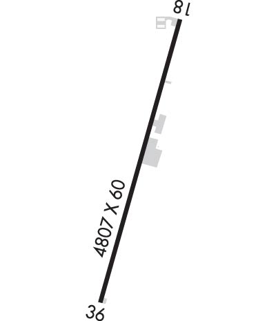
| Lat: N 4206.2 Long: W 12340.9 Elev: 1394 Var: -18 Longest Runway: 4807 | ||
| CTAF: 122.9 | ||
| ||||||||||||||||||||||||||||||||
| ||||||||||||||||||||||||||||||||
| Rwy | Rwy | |||||||
| 4807x60 | 4682' | 4807x60 | 4807' | |||||
| Runway ID | Single Wheel | Double Wheel | Double Tandem Wheel | Dual Double Wheel |
| 18/36 | 20,000 | 30,000 | N/A | N/A |
| These numbers are Advisory and are not limits. The Airport Manager should have more accurate Weight Limits | ||||
| FltPlan does not have IFR approach charts available for K3S4. |
 Airport Diagram might not be current. | |
| Facility Name: | ILLINOIS VALLEY |
| City Name: | CAVE JUNCTION |
| County: | JOSEPHINE |
| State abbrev: | OR |
| State Name: | OREGON |
| Ownership: | PUBLICLY OWNED |
| Use: | OPEN TO THE PUBLIC |
| Owner's Name: | JOSEPHINE COUNTY AIRPORTS |
| Address: | 1441 BROOKSIDE BLVD |
| GRANTS PASS, OR 97526 | |
| Owner's Phone: | 541-955-4535 |
| Manager's Name: | MICHAEL CRISAFULLI |
| Address: | 1441 BROOKSIDE BLVD |
| GRANTS PASS, OR 97526 | |
| Phone: | 541-955-4535 |
| FAA Region: | NORTHWEST MOUNTAIN |
| FAA Field Office: | SEA |
| Date | Sunrise | Sunset |
|---|---|---|
| 04/27/26 Monday | 6:16 | 20:09 |
| 04/28/26 Tuesday | 6:15 | 20:10 |
| 04/29/26 Wednesday | 6:13 | 20:11 |
| 04/30/26 Thursday | 6:12 | 20:13 |
| 05/01/26 Friday | 6:11 | 20:14 |
| 05/02/26 Saturday | 6:09 | 20:15 |
| 05/03/26 Sunday | 6:08 | 20:16 |
| 05/04/26 Monday | 6:07 | 20:17 |
| 05/05/26 Tuesday | 6:05 | 20:18 |
| 05/06/26 Wednesday | 6:04 | 20:19 |
| 05/07/26 Thursday | 6:03 | 20:20 |
| 05/08/26 Friday | 6:02 | 20:21 |
| 05/09/26 Saturday | 6:01 | 20:22 |
| 05/10/26 Sunday | 5:59 | 20:23 |
| Airport Attendance Schedule | M-F 0800-1700 |
| Airport Status | OPERATIONAL (This Status can change at any time - please check NOTAMS) |
| Airport Lighting Schedule | ACTVT REIL 18 & 36; MIRL RWY 18/36 - CTAF. |
| Airport Storage Available | Tie Downs |
| Extra Services Available | Flight Instruction |
| Wind Indicator | YES - (lighted) |
| Control Tower | NO |
| CTAF Frequency | 122.900; AUTOMATED UNICOM. ADZY ALSO AVBL BY CALLING 617-262-3825. |
| Unicom Frequency | |
| Rotating Beacon Color | WG |
| Segmented Circle | YES |
| Landing Fee | NO |
| Airport Inspected | STATE - performed by STATE AERONAUTICAL PERSONNEL |
| Inspection Date | 09/10/2024 |
| Type of Fuel Available | None |
| Airframe Repair Service | NONE |
| Power Plant Repair Service | NONE |
| Latitude | N4206.2 |
| Longitude | W12340.9 (ESTIMATED) |
| Arpt Elevation | 1394ft (ESTIMATED) |
| Magnetic Variation | 18E |
| 4 miles SW | of CAVE JUNCTION |
| Traffic Pattern Altitude | |
| Sectional Chart | KLAMATH FALLS |
| Operations (Reported) | Yearly | Avg. Daily |
|---|---|---|
| General Aviation Transient | 0 | 0 |
| General Aviation Local | 0 | 0 |
| Air Taxi | 0 | 0 |
| Commerical | 0 | 0 |
| Commuter | 0 | 0 |
| Military | 0 | 0 |
| Aircraft based on Field | |
|---|---|
| General Aviation Singles | 0 |
| General Aviation Multi | 0 |
| Jet Aircraft | 0 |
| General Aviation Helicopters | 0 |
| Military Aircraft | 0 |
| Gliders | 0 |
| Ultralights | 0 |
| FSS on field | NO |
| FSS tie-in | MC MINNVILLE |
| FSS Phone | 1-800-WX-BRIEF |
| Who issues Notams | MMV |
| Notam D service at airport | YES |
| ARTCC Name | SEATTLE |
| Airport Certification | |
| Aircraft Rescue & Firefighting Index | None |
| Airport of Entry | No |
| Custom Landing Rights | No |
| Joint Civil/Military | No |
| Military Landing rights | YES |
| NATIONAL PLAN OF INTEGRATED AIRPORT SYSTEMS (NPIAS) |
| GRANT AGREEMENTS UNDER FAAP/ADAP/AIP |
| ASSURANCES PURSUANT TO TITLE VI, CIVIL RIGHTS ACT OF 1964 |
| (E94) USFS WX STN. |
| RY 36 DESIGNATED CALM WIND RY. |
| FREQUENT ULTRA-LIGHT ACTIVITY. |
| RWY HAS BASIC MARKINGS WITH SIDE STRIPES |
| FOR CD CTC SEATTLE ARTCC AT 253-351-3694. |
| 4 FT BRUSH IN PRI SFC AREA. |
| RWY 18/3 6 MIRL SET 1 FT OFF RWY EDGE |
| Runway: 18 | Runway: 36 | ||
| Mag heading: | 179° | Mag heading: | 359° |
| Rwy Slope: | .85% Up | Rwy Slope: | -.85% Down |
| Approach: | Approach: | ||
| Pattern: | Left Traffic | Pattern: | Left Traffic |
| Markings: | BASIC | Markings: | BASIC |
| Marking Condition: | GOOD | Marking Condition: | GOOD |
| Arresting Dev: | Arresting Dev: | ||
| Lat & Long: | N4206.6 W12340.8 | Lat. & Long.: | N4205.8 W12341.1 |
| Elev: | 1353.0 ft. MSL | Elev: | 1394.0 ft. MSL |
| TCH: | 57 ft. AGL | TCH: | 52 ft. AGL |
| Visual Glide Path: | 4.00 degrees | Visual Glide Path: | 4.00 degrees |
| Displaced Threshold: | 125 feet | Displaced Threshold: | No |
| Touchdown Zone: | YES | Touchdown Zone: | YES |
| Touchdown Elev.: | 1376.0 feet | Touchdown Elev.: | 1394.0 feet |
| Visual Glide Slope: | 2-Light PAPI on LEFT side of Runway | Visual Glide Slope: | 2-Light PAPI on LEFT side of Runway |
| RVR Equipment: | RVR Equipment: | ||
| RVV Equipment: | NO | RVV Equipment: | NO |
| Approach Lights: | Approach Lights: | ||
| REIL: | YES | REIL: | YES |
| Centerline Lights: | NO | Centerline Lights: | NO |
| Touchdown lights: | NO | Touchdown lights: | NO |
| Runway Category: | Runway with a Visual Approach | Runway Category: | Runway with a Visual Approach |
| Declared Distances: | TORA:4807' TODA:4807' ASDA:4807' LDA:4682' | Declared Distances: | TORA:4682' TODA:4682' ASDA:4807' LDA:4682' |
| Obstructions: | ROAD | Obstructions: | TREES |
| Marked: | NOT Marked/Lighted | Marked: | NOT Marked/Lighted |
| Clearance slope: | 4:1; RWY 18 14:1 BASED ON DTHR. RWY 18 15 FT ROAD AT 330 FT ON CL 22:1 BASED ON DTHR | Clearance slope: | 13:1 |
| Obstruction height: | 15 feet AGL | Obstruction height: | 54 feet AGL |
| Dist. from runway: | 260 feet | Dist. from runway: | 928 feet |
| Centerline offset: | 170B | Centerline offset: | 113 feet right of centerline |
| Comments: | Comments: |
Thanks for using FltPlan.com
all rights reserved © 1999-2026 by Flight Plan LLC
