
| HOBART SKY RANCH HOBART IN |
| |
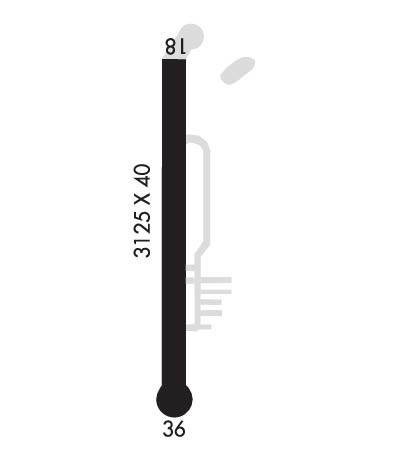
| Lat: N 4133.4 Long: W 08715.8 Elev: 630 Var: +01 Longest Runway: 3125 | ||
| CTAF: 122.8 | ||
| ||||||||||||||||||||||||||||||||||||||||||||
| ||||||||||||||||||||||||||||||||||||||||||||
| Rwy | Rwy | |||||||
| 3125x40 | 3125' | 3125x40 | 3125' | |||||
| Runway ID | Single Wheel | Double Wheel | Double Tandem Wheel | Dual Double Wheel |
| 18/36 | N/A | N/A | N/A | N/A |
| These numbers are Advisory and are not limits. The Airport Manager should have more accurate Weight Limits | ||||
 Airport Diagram might not be current. | |
| Facility Name: | HOBART SKY RANCH |
| City Name: | HOBART |
| County: | LAKE |
| State abbrev: | IN |
| State Name: | INDIANA |
| Ownership: | PRIVATELY OWNED |
| Use: | OPEN TO THE PUBLIC |
| Owner's Name: | DON NIEMEYER |
| Address: | 3600 N LAKE PARK AVENUE |
| HOBART, IN 46342 | |
| Owner's Phone: | 219-962-3020 |
| Manager's Name: | DON NIEMEYER |
| Address: | 3600 N LAKE PARK AVENUE |
| HOBART, IN 46342 | |
| Phone: | 219-962-3020 |
| FAA Region: | GREAT LAKES |
| FAA Field Office: | CHI |
| Date | Sunrise | Sunset |
|---|---|---|
| 05/03/26 Sunday | 5:44 | 19:49 |
| 05/04/26 Monday | 5:42 | 19:50 |
| 05/05/26 Tuesday | 5:41 | 19:51 |
| 05/06/26 Wednesday | 5:40 | 19:52 |
| 05/07/26 Thursday | 5:39 | 19:53 |
| 05/08/26 Friday | 5:38 | 19:54 |
| 05/09/26 Saturday | 5:36 | 19:55 |
| 05/10/26 Sunday | 5:35 | 19:56 |
| 05/11/26 Monday | 5:34 | 19:57 |
| 05/12/26 Tuesday | 5:33 | 19:58 |
| 05/13/26 Wednesday | 5:32 | 19:59 |
| 05/14/26 Thursday | 5:31 | 20:00 |
| 05/15/26 Friday | 5:30 | 20:01 |
| 05/16/26 Saturday | 5:29 | 20:02 |
| Airport Attendance Schedule | 7 Days A Week 0800-1700 |
| Airport Status | OPERATIONAL (This Status can change at any time - please check NOTAMS) |
| Airport Lighting Schedule | |
| Airport Storage Available | Tie Downs, Hanger |
| Extra Services Available | Flight Instruction, Aircraft Rental |
| Wind Indicator | YES - (unlit) |
| Control Tower | NO |
| CTAF Frequency | 122.800 |
| Unicom Frequency | 122.800 |
| Rotating Beacon Color | |
| Segmented Circle | NO |
| Landing Fee | NO |
| Airport Inspected | STATE - performed by STATE AERONAUTICAL PERSONNEL |
| Inspection Date | 05/27/2021 |
| Type of Fuel Available | Grade 100LL |
| Airframe Repair Service | None |
| Power Plant Repair Service | None |
| Latitude | N4133.4 |
| Longitude | W08715.8 (ESTIMATED) |
| Arpt Elevation | 630ft (ESTIMATED) |
| Magnetic Variation | 01W |
| 2 miles NW | of HOBART |
| Traffic Pattern Altitude | |
| Sectional Chart | CHICAGO |
| Operations (Reported) | Yearly | Avg. Daily |
|---|---|---|
| General Aviation Transient | 0 | 0 |
| General Aviation Local | 0 | 0 |
| Air Taxi | 0 | 0 |
| Commerical | 0 | 0 |
| Commuter | 0 | 0 |
| Military | 0 | 0 |
| Aircraft based on Field | |
|---|---|
| General Aviation Singles | 0 |
| General Aviation Multi | 0 |
| Jet Aircraft | 0 |
| General Aviation Helicopters | 0 |
| Military Aircraft | 0 |
| Gliders | 0 |
| Ultralights | 0 |
| FSS on field | NO |
| FSS tie-in | TERRE HAUTE |
| FSS Phone | 1-800-WX-BRIEF |
| Who issues Notams | HUF |
| Notam D service at airport | YES |
| ARTCC Name | CHICAGO |
| Airport Certification | |
| Aircraft Rescue & Firefighting Index | None |
| Airport of Entry | No |
| Custom Landing Rights | No |
| Joint Civil/Military | No |
| Military Landing rights | No |
| TRAILER PARK 155 FT WEST OF RWY |
| FOR CD CTC CHICAGO APCH AT 847-289-0926. |
| RWY 18/3 6 RWY PAVEMENT & SHOULDER SPALLING. WEED GROWTH WITHIN RWY. |
Airport Communications & Frequencies:
| |||||||||
| Runway: 18 | Runway: 36 | ||
| Mag heading: | 181° | Mag heading: | 1° |
| Rwy Slope: | .00% Up | Rwy Slope: | .00% Down |
| Approach: | Approach: | ||
| Pattern: | Left Traffic | Pattern: | Left Traffic |
| Markings: | NONSTANDARD | Markings: | BASIC |
| Marking Condition: | POOR; NUMBERING SMALLER THAN STD & OFFSET TO L SIDE OF RWY. NON STD DSPLCD THLD MARKINGS. | Marking Condition: | POOR; NUMBERING SMALLER THAN STD. NON STD DSPLCD THLD MARKINGS. |
| Arresting Dev: | Arresting Dev: | ||
| Lat & Long: | N4133.6 W08715.8 | Lat. & Long.: | N4133.1 W08715.8 |
| Elev: | 630.0 ft. MSL | Elev: | 630.1 ft. MSL |
| TCH: | TCH: | ||
| Visual Glide Path: | Visual Glide Path: | ||
| Displaced Threshold: | No | Displaced Threshold: | No |
| Touchdown Zone: | YES | Touchdown Zone: | YES |
| Touchdown Elev.: | 630.0 feet | Touchdown Elev.: | 630.1 feet |
| Visual Glide Slope: | Visual Glide Slope: | ||
| RVR Equipment: | RVR Equipment: | ||
| RVV Equipment: | NO | RVV Equipment: | NO |
| Approach Lights: | Approach Lights: | ||
| REIL: | NO | REIL: | NO |
| Centerline Lights: | NO | Centerline Lights: | NO |
| Touchdown lights: | NO | Touchdown lights: | NO |
| Runway Category: | Runway with a Visual Approach | Runway Category: | Runway with a Visual Approach |
| Declared Distances: | Declared Distances: | ||
| Obstructions: | TREES | Obstructions: | TREES |
| Marked: | NOT Marked/Lighted | Marked: | NOT Marked/Lighted |
| Clearance slope: | APCH SLOPE 14:1 AT DSPLCD THR. | Clearance slope: | APCH SLOPE 22:1. |
| Obstruction height: | 60 feet AGL | Obstruction height: | 70 feet AGL |
| Dist. from runway: | 201 feet | Dist. from runway: | 201 feet |
| Centerline offset: | Centerline offset: | ||
| Comments: | 15 FT ROAD 130 FT FM RWY END | Comments: | 40 FT TREES FM RWY END, 50 FT TO 70 FT L & R OF RWY |
Thanks for using FltPlan.com
all rights reserved © 1999-2026 by Flight Plan LLC
