
| PRU FIELD RITZVILLE WA |
| |
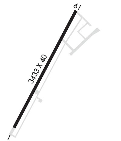
| Lat: N 4707.4 Long: W 11823.4 Elev: 1801 Var: -19 Longest Runway: 3433 | ||
| CTAF: 122.8 | ||
| ||||||||||||||||||||||||||||||||
| ||||||||||||||||||||||||||||||||
| Rwy | Rwy | |||||||
| 3433x40 | 3433' | 3433x40 | 2613' | |||||
| Runway ID | Single Wheel | Double Wheel | Double Tandem Wheel | Dual Double Wheel |
| 01/19 | 12,500 | N/A | N/A | N/A |
| These numbers are Advisory and are not limits. The Airport Manager should have more accurate Weight Limits | ||||
| FltPlan does not have IFR approach charts available for K33S. |
 Airport Diagram might not be current. | |
| Facility Name: | PRU FLD |
| City Name: | RITZVILLE |
| County: | ADAMS |
| State abbrev: | WA |
| State Name: | WASHINGTON |
| Ownership: | PUBLICLY OWNED |
| Use: | OPEN TO THE PUBLIC |
| Owner's Name: | CITY OF RITZVILLE |
| Address: | 216 E. MAIN |
| RITZVILLE, WA 99169-1417 | |
| Owner's Phone: | 509-659-1930 |
| Manager's Name: | DAVE BREAZEALE |
| Address: | 216 E. MAIN |
| RITZVILLE, WA 99169-1417 | |
| Phone: | 509-659-1930 |
| FAA Region: | NORTHWEST MOUNTAIN |
| FAA Field Office: | SEA |
| Date | Sunrise | Sunset |
|---|---|---|
| 05/02/25 Friday | 5:36 | 20:06 |
| 05/03/25 Saturday | 5:35 | 20:07 |
| 05/04/25 Sunday | 5:33 | 20:08 |
| 05/05/25 Monday | 5:32 | 20:10 |
| 05/06/25 Tuesday | 5:30 | 20:11 |
| 05/07/25 Wednesday | 5:29 | 20:12 |
| 05/08/25 Thursday | 5:27 | 20:14 |
| 05/09/25 Friday | 5:26 | 20:15 |
| 05/10/25 Saturday | 5:24 | 20:16 |
| 05/11/25 Sunday | 5:23 | 20:17 |
| 05/12/25 Monday | 5:22 | 20:19 |
| 05/13/25 Tuesday | 5:20 | 20:20 |
| 05/14/25 Wednesday | 5:19 | 20:21 |
| 05/15/25 Thursday | 5:18 | 20:23 |
| Airport Attendance Schedule | UNATTENDED |
| Airport Status | OPERATIONAL (This Status can change at any time - please check NOTAMS) |
| Airport Lighting Schedule | ACTVT MIRL RY 01/19 AND PAPI RYS 01 & 19 - CTAF. |
| Airport Storage Available | Tie Downs |
| Extra Services Available | Crop Dusting |
| Wind Indicator | YES - (lighted) |
| Control Tower | NO |
| CTAF Frequency | 122.800 |
| Unicom Frequency | 122.800 |
| Rotating Beacon Color | WG |
| Segmented Circle | NO |
| Landing Fee | NO |
| Airport Inspected | STATE - performed by STATE AERONAUTICAL PERSONNEL |
| Inspection Date | 08/08/2022 |
| Type of Fuel Available | None |
| Airframe Repair Service | NONE |
| Power Plant Repair Service | NONE |
| Latitude | N4707.4 |
| Longitude | W11823.4 (ESTIMATED) |
| Arpt Elevation | 1801ft (SURVEYED) |
| Magnetic Variation | 19E |
| 1 miles W | of RITZVILLE |
| Traffic Pattern Altitude | |
| Sectional Chart | SEATTLE |
| Operations (Reported) | Yearly | Avg. Daily |
|---|---|---|
| General Aviation Transient | 0 | 0 |
| General Aviation Local | 0 | 0 |
| Air Taxi | 0 | 0 |
| Commerical | 0 | 0 |
| Commuter | 0 | 0 |
| Military | 0 | 0 |
| Aircraft based on Field | |
|---|---|
| General Aviation Singles | 0 |
| General Aviation Multi | 0 |
| Jet Aircraft | 0 |
| General Aviation Helicopters | 0 |
| Military Aircraft | 0 |
| Gliders | 0 |
| Ultralights | 0 |
| FSS on field | NO |
| FSS tie-in | SEATTLE |
| FSS Phone | 1-800-WX-BRIEF |
| Who issues Notams | SEA |
| Notam D service at airport | YES |
| ARTCC Name | SEATTLE |
| Airport Certification | |
| Aircraft Rescue & Firefighting Index | None |
| Airport of Entry | No |
| Custom Landing Rights | No |
| Joint Civil/Military | No |
| Military Landing rights | No |
| NATIONAL PLAN OF INTEGRATED AIRPORT SYSTEMS (NPIAS) |
| ARPT CLSD WHEN SNOW/ICE ON RY. |
| FOR CD CTC GRANT COUNTY APCH AT 509-762-2842, WHEN APCH CLSD CTC SEATTLE ARTCC AT 253-351-3694. |
| Runway: 01 | Runway: 19 | ||
| Mag heading: | 9° | Mag heading: | 189° |
| Rwy Slope: | .52% Up | Rwy Slope: | -.52% Down |
| Approach: | Approach: | ||
| Pattern: | Left Traffic | Pattern: | Left Traffic |
| Markings: | BASIC | Markings: | BASIC |
| Marking Condition: | FAIR | Marking Condition: | FAIR |
| Arresting Dev: | Arresting Dev: | ||
| Lat & Long: | N4707.2 W11823.6 | Lat. & Long.: | N4707.7 W11823.2 |
| Elev: | 1783.0 ft. MSL | Elev: | 1801.0 ft. MSL |
| TCH: | 40 ft. AGL | TCH: | 45 ft. AGL |
| Visual Glide Path: | 4.00 degrees | Visual Glide Path: | 3.50 degrees |
| Displaced Threshold: | No | Displaced Threshold: | 820 feet |
| Touchdown Zone: | YES | Touchdown Zone: | YES |
| Touchdown Elev.: | 1799.0 feet | Touchdown Elev.: | 1801.0 feet |
| Visual Glide Slope: | 2-Light PAPI on LEFT side of Runway | Visual Glide Slope: | 2-Light PAPI on RIGHT side of Runway |
| RVR Equipment: | RVR Equipment: | ||
| RVV Equipment: | NO | RVV Equipment: | NO |
| Approach Lights: | Approach Lights: | ||
| REIL: | NO | REIL: | NO |
| Centerline Lights: | NO | Centerline Lights: | NO |
| Touchdown lights: | NO | Touchdown lights: | NO |
| Runway Category: | Runway with a Visual Approach | Runway Category: | Runway with a Visual Approach |
| Declared Distances: | TORA:2614' TODA:2614' ASDA:3433' LDA:3433' | Declared Distances: | TORA:3433' TODA:3433' ASDA:3433' LDA:2614' |
| Obstructions: | PLINE | Obstructions: | TREE |
| Marked: | NOT Marked/Lighted | Marked: | NOT Marked/Lighted |
| Clearance slope: | 39:1 | Clearance slope: | 7:1 |
| Obstruction height: | 27 feet AGL | Obstruction height: | 48 feet AGL |
| Dist. from runway: | 1282 feet | Dist. from runway: | 540 feet |
| Centerline offset: | 69 right of centerline | Centerline offset: | 32 feet right of centerline |
| Comments: | Comments: | HOUSES, ROAD, SIGNS, AND TRESS FM 0-200 FT OF THR. 60 FT TREE 170 FT FM THR, 70 FT R. |
Thanks for using FltPlan.com
all rights reserved © 1999-2025 by Flight Plan LLC
