| SOMERSET COUNTY SOMERSET PA |
| |
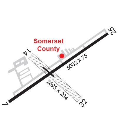
| Lat: N 4002.3 Long: W 07900.9 Elev: 2275 Var: +10 Longest Runway: 5002 | ||
| AWOS: 133.8 CTAF: 122.8 | ||
| ||||||||||||||||||||||||||||||
| ||||||||||||||||||||||||||||||
| ||||||||||||||||||||||||||||||
| Rwy | Rwy | |||||||
| 5002x75 | 5002' | 5002x75 | 5002' | 108.70 - 246° | ||||
| 2729x150 | 2394' | 2729x150 | 2729' | |||||
| Runway ID | Single Wheel | Double Wheel | Double Tandem Wheel | Dual Double Wheel |
| 07/25 | 18,000 | N/A | N/A | N/A |
| 14/32 | N/A | N/A | N/A | N/A |
| These numbers are Advisory and are not limits. The Airport Manager should have more accurate Weight Limits | ||||
 Airport Diagram might not be current. | |
| Facility Name: | SOMERSET COUNTY |
| City Name: | SOMERSET |
| County: | SOMERSET |
| State abbrev: | PA |
| State Name: | PENNSYLVANIA |
| Ownership: | PUBLICLY OWNED |
| Use: | OPEN TO THE PUBLIC |
| Owner's Name: | BD OF CO COMMISSIONERS |
| Address: | SOMERSET COUNTY COURTHOUSE |
| SOMERSET, PA 15501 | |
| Owner's Phone: | 814-445-1400 |
| Manager's Name: | DAVID WRIGHT |
| Address: | 159 AIRPORT LANE |
| FRIEDENS, PA 15541 | |
| Phone: | 814-445-1599 |
| FAA Region: | EASTERN |
| FAA Field Office: | HAR |

| Date | Sunrise | Sunset |
|---|---|---|
| 09/24/21 Friday | 7:05 | 19:10 |
| 09/25/21 Saturday | 7:06 | 19:09 |
| 09/26/21 Sunday | 7:07 | 19:07 |
| 09/27/21 Monday | 7:08 | 19:05 |
| 09/28/21 Tuesday | 7:09 | 19:04 |
| 09/29/21 Wednesday | 7:10 | 19:02 |
| 09/30/21 Thursday | 7:11 | 19:00 |
| 10/01/21 Friday | 7:12 | 18:59 |
| 10/02/21 Saturday | 7:13 | 18:57 |
| 10/03/21 Sunday | 7:14 | 18:56 |
| 10/04/21 Monday | 7:15 | 18:54 |
| 10/05/21 Tuesday | 7:16 | 18:52 |
| 10/06/21 Wednesday | 7:17 | 18:51 |
| 10/07/21 Thursday | 7:18 | 18:49 |
| Airport Attendance Schedule | 7 Days A Week 0800-1600*; UNATNDD NEW YEARS DAY, EASTER, THANKSGIVING, DAY AFT THANKSGIVING, CHRISTMAS DAY AND ALL FEDERAL HOLS. |
| Airport Status | OPERATIONAL (This Status can change at any time - please check NOTAMS) |
| Airport Lighting Schedule | MIRL RWY 07/25 & TWY LGTS ON DUSK-0000; ACTVT REIL RWY 07/25, PAPI RWY 07; PVASI RWY 25; - CTAF. |
| Airport Storage Available | Tie Downs, Hanger |
| Extra Services Available | NONE |
| Wind Indicator | YES - (lighted) |
| Control Tower | NO |
| CTAF Frequency | 122.800 |
| Unicom Frequency | 122.800 |
| Rotating Beacon Color | CLEAR-GREEN (Light Land Airport) |
| Segmented Circle | YES |
| Landing Fee | NO |
| Airport Inspected | STATE - performed by STATE AERONAUTICAL PERSONNEL |
| Inspection Date | 11/15/2019 |
| Type of Fuel Available | Grade 100LL, JET A (freeze point -40C), JET A; -A SINGLE POINT REFUELING AVBL UPON REQUEST.; -1024 HR SELF-SERVICE FUELING AVBL. |
| Airframe Repair Service | NONE |
| Power Plant Repair Service | NONE |
| Latitude | N4002.3 |
| Longitude | W07900.9 (ESTIMATED) |
| Arpt Elevation | 2275ft (SURVEYED) |
| Magnetic Variation | 10W |
| 3 miles NE | of SOMERSET |
| Traffic Pattern Altitude | |
| Sectional Chart | DETROIT |
| Operations (Reported) | Yearly | Avg. Daily |
|---|---|---|
| General Aviation Transient | 2200 | 6 |
| General Aviation Local | 10900 | 30 |
| Air Taxi | 370 | 1 |
| Commerical | 0 | 0 |
| Commuter | 0 | 0 |
| Military | 2500 | 7 |
| Aircraft based on Field | |
|---|---|
| General Aviation Singles | 16 |
| General Aviation Multi | 3 |
| Jet Aircraft | 1 |
| General Aviation Helicopters | 0 |
| Military Aircraft | 0 |
| Gliders | 0 |
| Ultralights | 0 |
| FSS on field | NO |
| FSS tie-in | ALTOONA |
| FSS Phone | 1-800-WX-BRIEF |
| Who issues Notams | AOO |
| Notam D service at airport | YES |
| ARTCC Name | CLEVELAND |
| Airport Certification | |
| Aircraft Rescue & Firefighting Index | None |
| Airport of Entry | No |
| Custom Landing Rights | No |
| Joint Civil/Military | No |
| Military Landing rights | YES |
| NATIONAL PLAN OF INTEGRATED AIRPORT SYSTEMS (NPIAS) |
| GRANT AGREEMENTS UNDER FAAP/ADAP/AIP |
| ASSURANCES PURSUANT TO TITLE VI, CIVIL RIGHTS ACT OF 1964 |
| FOR CD CTC JOHNSTOWN APCH AT 814-532-5960, WHEN APCH CLSD CTC CLEVELAND ARTCC AT 440-774-0234. |
| RWY 14/32 UNUSBL DURING SPRING THAW, WET PERIODS & SNOW; CHECK NOTAMS. |
| RWY 14/3 2 617 FT BY 60 FT ASPH AT INTXN WITH RWY 07/25 & PARL TWY. |
Airport Communications & Frequencies:
| |||||||||||||||||
| Runway: 07 | Runway: 25 | ||
| Mag heading: | 66° | Mag heading: | 246° |
| Rwy Slope: | -1.47% Down | Rwy Slope: | 1.47% Up |
| Approach: | Approach: | LOCALIZER | |
| Pattern: | Left Traffic | Pattern: | Left Traffic |
| Markings: | NONPRECISION INSTRUMENT | Markings: | NONPRECISION INSTRUMENT |
| Marking Condition: | FAIR | Marking Condition: | FAIR |
| Arresting Dev: | Arresting Dev: | ||
| Lat & Long: | N4002.1 W07901.3 | Lat. & Long.: | N4002.6 W07900.5 |
| Elev: | 2275.0 ft. MSL | Elev: | 2201.6 ft. MSL |
| TCH: | 56 ft. AGL | TCH: | 29 ft. AGL |
| Visual Glide Path: | 3.00 degrees | Visual Glide Path: | 3.00 degrees |
| Displaced Threshold: | No | Displaced Threshold: | No |
| Touchdown Zone: | YES | Touchdown Zone: | YES |
| Touchdown Elev.: | 2275.0 feet | Touchdown Elev.: | 2240.3 feet |
| Visual Glide Slope: | 2-Light PAPI on LEFT side of Runway | Visual Glide Slope: | PULSATING/STEADY BURNING VASI ON LEFT SIDE OF RUNWAY |
| RVR Equipment: | RVR Equipment: | ||
| RVV Equipment: | NO | RVV Equipment: | NO |
| Approach Lights: | Approach Lights: | ||
| REIL: | YES | REIL: | YES |
| Centerline Lights: | NO | Centerline Lights: | NO |
| Touchdown lights: | NO | Touchdown lights: | NO |
| Runway Category: | Runway with a Non-precision Approach having visibility minimums greater than 3/4 mile | Runway Category: | Runway with a Non-precision Approach having visibility minimums greater than 3/4 mile |
| Declared Distances: | Declared Distances: | ||
| Obstructions: | Obstructions: | POLE | |
| Marked: | Marked: | NOT Marked/Lighted | |
| Clearance slope: | 34:1 | Clearance slope: | 19:1 |
| Obstruction height: | Obstruction height: | 18 feet AGL | |
| Dist. from runway: | Dist. from runway: | 544 feet | |
| Centerline offset: | Centerline offset: | 180 feet left of centerline | |
| Comments: | Comments: |
| Runway: 14 | Runway: 32 | ||
| Mag heading: | 141° | Mag heading: | 321° |
| Rwy Slope: | 1.01% Up | Rwy Slope: | -1.01% Down |
| Approach: | Approach: | ||
| Pattern: | Left Traffic | Pattern: | Left Traffic |
| Markings: | NONSTANDARD | Markings: | NONSTANDARD |
| Marking Condition: | GOOD; YELLOW CONES | Marking Condition: | GOOD; YELLOW CONES |
| Arresting Dev: | Arresting Dev: | ||
| Lat & Long: | N4002.4 W07901.2 | Lat. & Long.: | N4002.1 W07900.7 |
| Elev: | 2227.8 ft. MSL | Elev: | 2255.4 ft. MSL |
| TCH: | TCH: | ||
| Visual Glide Path: | Visual Glide Path: | ||
| Displaced Threshold: | 335 feet; 335 FT DTHR MKD WITH YELLOW CONES. | Displaced Threshold: | No |
| Touchdown Zone: | YES | Touchdown Zone: | YES |
| Touchdown Elev.: | 2255.4 feet | Touchdown Elev.: | 2255.4 feet |
| Visual Glide Slope: | Visual Glide Slope: | ||
| RVR Equipment: | RVR Equipment: | ||
| RVV Equipment: | NO | RVV Equipment: | NO |
| Approach Lights: | Approach Lights: | ||
| REIL: | NO | REIL: | NO |
| Centerline Lights: | NO | Centerline Lights: | NO |
| Touchdown lights: | NO | Touchdown lights: | NO |
| Runway Category: | Runway with a Visual Approach | Runway Category: | Runway with a Visual Approach |
| Declared Distances: | Declared Distances: | ||
| Obstructions: | ROAD; ROAD ANGLES ACRS RCL. | Obstructions: | TREES |
| Marked: | NOT Marked/Lighted | Marked: | NOT Marked/Lighted |
| Clearance slope: | 2:1; RWY 14 36 FT TREES 578 FT FM RWY 9 FT L. 25:1 BASED ON DTHR. | Clearance slope: | 16:1 |
| Obstruction height: | 16 feet AGL | Obstruction height: | 22 feet AGL |
| Dist. from runway: | 40 feet | Dist. from runway: | 352 feet |
| Centerline offset: | 124 left of centerline | Centerline offset: | 74 feet left of centerline |
| Comments: | Comments: |
Thanks for using FltPlan.com
all rights reserved © 1999-2021 by Flight Plan LLC