
| GROVE CITY GROVE CITY PA |
| |
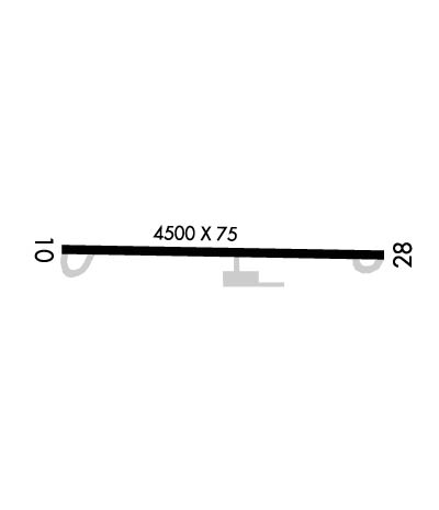
| Lat: N 4108.8 Long: W 08010.1 Elev: 1370 Var: +09 Longest Runway: 4500 | ||
| CTAF: 122.72 | ||
| ||||||||||||||||||||||||||||||||||||||||||||||||||||||||||||||||||||
| ||||||||||||||||||||||||||||||||||||||||||||||||||||||||||||||||||||
| Rwy | Rwy | |||||||
| 4500x75 | 4500' | 4500x75 | 4500' | |||||
| Runway ID | Single Wheel | Double Wheel | Double Tandem Wheel | Dual Double Wheel |
| 10/28 | 12,500 | N/A | N/A | N/A |
| These numbers are Advisory and are not limits. The Airport Manager should have more accurate Weight Limits | ||||
 Airport Diagram might not be current. | |
| Facility Name: | GROVE CITY |
| City Name: | GROVE CITY |
| County: | MERCER |
| State abbrev: | PA |
| State Name: | PENNSYLVANIA |
| Ownership: | PUBLICLY OWNED |
| Use: | OPEN TO THE PUBLIC |
| Owner's Name: | BOROUGH OF GROVE CITY |
| Address: | 123 W MAIN ST. P.O. BOX 110 |
| GROVE CITY, PA 16127 | |
| Owner's Phone: | 724-458-7060 |
| Manager's Name: | MICHAEL BAUN |
| Address: | GROVE CITY AIRPORT, 40 OAKLEY KELLY DRIVE |
| MERCER, PA 16137-8411 | |
| Phone: | 724-748-5530 |
| FAA Region: | EASTERN |
| FAA Field Office: | HAR |
| Date | Sunrise | Sunset |
|---|---|---|
| 09/24/21 Friday | 7:10 | 19:15 |
| 09/25/21 Saturday | 7:11 | 19:13 |
| 09/26/21 Sunday | 7:12 | 19:11 |
| 09/27/21 Monday | 7:13 | 19:10 |
| 09/28/21 Tuesday | 7:14 | 19:08 |
| 09/29/21 Wednesday | 7:15 | 19:06 |
| 09/30/21 Thursday | 7:16 | 19:05 |
| 10/01/21 Friday | 7:17 | 19:03 |
| 10/02/21 Saturday | 7:18 | 19:01 |
| 10/03/21 Sunday | 7:19 | 19:00 |
| 10/04/21 Monday | 7:20 | 18:58 |
| 10/05/21 Tuesday | 7:21 | 18:56 |
| 10/06/21 Wednesday | 7:22 | 18:55 |
| 10/07/21 Thursday | 7:23 | 18:53 |
| Airport Attendance Schedule | MON-FRI 0800-1600; UNATNDD THANKSGIVING, CHRISTMAS & NEW YEAR'S DAY. |
| Airport Status | OPERATIONAL (This Status can change at any time - please check NOTAMS) |
| Airport Lighting Schedule | ACTVT PAPI RWY 10 & 28; MIRL RWY 10/28 - CTAF. |
| Airport Storage Available | Tie Downs, Hanger |
| Extra Services Available | Air Ambulance, Parachute Jumping |
| Wind Indicator | YES - (lighted) |
| Control Tower | NO |
| CTAF Frequency | 122.725 |
| Unicom Frequency | 122.725 |
| Rotating Beacon Color | CLEAR-GREEN (Light Land Airport) |
| Segmented Circle | YES |
| Landing Fee | NO |
| Airport Inspected | STATE - performed by STATE AERONAUTICAL PERSONNEL |
| Inspection Date | 09/22/2020 |
| Type of Fuel Available | Grade 100LL, JET A (freeze point -40C); -1024 HR FUEL AVBL WITH CREDIT CARD.; -A JET-A ANTI-ICE INHIBITOR AVBL ON REQ. |
| Airframe Repair Service | None |
| Power Plant Repair Service | None |
| Latitude | N4108.8 |
| Longitude | W08010.1 (ESTIMATED) |
| Arpt Elevation | 1370ft (SURVEYED) |
| Magnetic Variation | 09W |
| 3 miles W | of GROVE CITY |
| Traffic Pattern Altitude | |
| Sectional Chart | DETROIT |
| Operations (Reported) | Yearly | Avg. Daily |
|---|---|---|
| General Aviation Transient | 7500 | 21 |
| General Aviation Local | 5000 | 14 |
| Air Taxi | 200 | 1 |
| Commerical | 0 | 0 |
| Commuter | 0 | 0 |
| Military | 50 | 0 |
| Aircraft based on Field | |
|---|---|
| General Aviation Singles | 14 |
| General Aviation Multi | 3 |
| Jet Aircraft | 1 |
| General Aviation Helicopters | 1 |
| Military Aircraft | 0 |
| Gliders | 0 |
| Ultralights | 0 |
| FSS on field | NO |
| FSS tie-in | ALTOONA |
| FSS Phone | 1-800-WX-BRIEF |
| Who issues Notams | AOO |
| Notam D service at airport | YES |
| ARTCC Name | CLEVELAND |
| Airport Certification | |
| Aircraft Rescue & Firefighting Index | None |
| Airport of Entry | No |
| Custom Landing Rights | No |
| Joint Civil/Military | No |
| Military Landing rights | YES |
| NATIONAL PLAN OF INTEGRATED AIRPORT SYSTEMS (NPIAS) |
| GRANT AGREEMENTS UNDER FAAP/ADAP/AIP |
| ADVANCE PLANNING AGREEMENT UNDER FAAP |
| ASSURANCES PURSUANT TO TITLE VI, CIVIL RIGHTS ACT OF 1964 |
| THIS AIRPORT HAS BEEN SURVEYED BY THE NATIONAL GEODETIC SURVEY. |
| DEER & GEESE ON AND INVOF ARPT. |
| DRAINAGE RAVINE 15 FT DEEP LCTD IN SAFETY AREA NORTH OF RY 10. |
| TWY LGTS STUB TO APRON. |
| AVOID OVERFLYING FLD DURG DALGT VFR BECAUSE OF PARACHUTE JUMPING ACTIVITY NW CORNER OF FLD. |
| FOR CD CTC YOUNGSTOWN APCH AT 330-856-4806, WHEN APCH CLSD CTC CLEVELAND ARTCC AT 440-774-0234. |
| PORTABLE GROUND PWR UNIT AVBL. |
Airport Communications & Frequencies:
| |||||||||||||||||
| Runway: 10 | Runway: 28 | ||
| Mag heading: | 101° | Mag heading: | 281° |
| Rwy Slope: | -1.62% Down | Rwy Slope: | 1.62% Up |
| Approach: | Approach: | ||
| Pattern: | Left Traffic | Pattern: | Left Traffic |
| Markings: | NONPRECISION INSTRUMENT | Markings: | NONPRECISION INSTRUMENT |
| Marking Condition: | GOOD | Marking Condition: | GOOD |
| Arresting Dev: | Arresting Dev: | ||
| Lat & Long: | N4108.8 W08010.6 | Lat. & Long.: | N4108.7 W08009.6 |
| Elev: | 1370.0 ft. MSL | Elev: | 1297.0 ft. MSL |
| TCH: | 37 ft. AGL | TCH: | 56 ft. AGL |
| Visual Glide Path: | 3.80 degrees | Visual Glide Path: | 3.00 degrees |
| Displaced Threshold: | No | Displaced Threshold: | No |
| Touchdown Zone: | YES | Touchdown Zone: | YES |
| Touchdown Elev.: | 1370.0 feet | Touchdown Elev.: | 1312.0 feet |
| Visual Glide Slope: | 2-Light PAPI on LEFT side of Runway; RWY 10 PAPI UNUSABLE BEYOND 5 DEGREES LEFT OF RUNWAY CENTERLINE. | Visual Glide Slope: | 2-Light PAPI on LEFT side of Runway |
| RVR Equipment: | RVR Equipment: | ||
| RVV Equipment: | NO | RVV Equipment: | NO |
| Approach Lights: | Approach Lights: | ||
| REIL: | YES | REIL: | YES |
| Centerline Lights: | NO | Centerline Lights: | NO |
| Touchdown lights: | NO | Touchdown lights: | NO |
| Runway Category: | Runway with a Non-precision Approach | Runway Category: | Runway with a Non-precision Approach |
| Declared Distances: | Declared Distances: | ||
| Obstructions: | BRUSH | Obstructions: | |
| Marked: | NOT Marked/Lighted | Marked: | |
| Clearance slope: | 8:1 | Clearance slope: | 20:1 |
| Obstruction height: | 14 feet AGL | Obstruction height: | |
| Dist. from runway: | 320 feet | Dist. from runway: | |
| Centerline offset: | 112 left of centerline | Centerline offset: | |
| Comments: | Comments: | RWY 28 3 FT BRUSH 185 FT FM THR 92 FT RT. 7 FT BRUSH 82 FT FM THR 143 FT LT. |
Thanks for using FltPlan.com
all rights reserved © 1999-2021 by Flight Plan LLC


