
| LAMPSON FIELD LAKEPORT CA |
| |
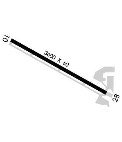
| Lat: N 3859.4 Long: W 12254.0 Elev: 1380 Var: -16 Longest Runway: 3600 | ||
| AWOS: 118.35 CTAF: 122.8 | ||
| ||||||||||||||||||||||||||||||||||||||||||||
| ||||||||||||||||||||||||||||||||||||||||||||
| ||||||||||||||||||||||||||||||||||||||||||||
| Rwy | Rwy | |||||||
| 3600x60 | 3600' | 3600x60 | 3515' | |||||
| Runway ID | Single Wheel | Double Wheel | Double Tandem Wheel | Dual Double Wheel |
| 10/28 | 30,000 | N/A | N/A | N/A |
| These numbers are Advisory and are not limits. The Airport Manager should have more accurate Weight Limits | ||||
 Airport Diagram might not be current. | |
| Facility Name: | LAMPSON FLD |
| City Name: | LAKEPORT |
| County: | LAKE |
| State abbrev: | CA |
| State Name: | CALIFORNIA |
| Ownership: | PUBLICLY OWNED |
| Use: | OPEN TO THE PUBLIC |
| Owner's Name: | LAKE COUNTY |
| Address: | 255 N FORBES ST |
| LAKEPORT, CA 95453 | |
| Owner's Phone: | 707-263-2341 |
| Manager's Name: | GLEN MARCH |
| Address: | 255 N FORBES ST #309 |
| LAKEPORT, CA 95453 | |
| Phone: | 707-263-2341; PRINCIPAL CIVIL ENGINEER; OFFICE IN LAKEPORT, CA. |
| FAA Region: | WESTERN-PACIFIC |
| FAA Field Office: | SFO |

| Date | Sunrise | Sunset |
|---|---|---|
| 04/02/26 Thursday | 6:55 | 19:36 |
| 04/03/26 Friday | 6:53 | 19:37 |
| 04/04/26 Saturday | 6:52 | 19:38 |
| 04/05/26 Sunday | 6:50 | 19:39 |
| 04/06/26 Monday | 6:49 | 19:40 |
| 04/07/26 Tuesday | 6:47 | 19:41 |
| 04/08/26 Wednesday | 6:46 | 19:42 |
| 04/09/26 Thursday | 6:44 | 19:43 |
| 04/10/26 Friday | 6:43 | 19:44 |
| 04/11/26 Saturday | 6:41 | 19:45 |
| 04/12/26 Sunday | 6:40 | 19:46 |
| 04/13/26 Monday | 6:38 | 19:47 |
| 04/14/26 Tuesday | 6:37 | 19:48 |
| 04/15/26 Wednesday | 6:35 | 19:49 |
| Airport Attendance Schedule | UNATTENDED |
| Airport Status | OPERATIONAL (This Status can change at any time - please check NOTAMS) |
| Airport Lighting Schedule | ACTVT MIRL RWY 10/28 - CTAF. |
| Airport Storage Available | Tie Downs |
| Extra Services Available | Air Ambulance, Aircraft Sales |
| Wind Indicator | YES - (lighted) |
| Control Tower | NO |
| CTAF Frequency | 122.800 |
| Unicom Frequency | 122.800 |
| Rotating Beacon Color | WG |
| Segmented Circle | YES |
| Landing Fee | NO |
| Airport Inspected | STATE - performed by STATE AERONAUTICAL PERSONNEL |
| Inspection Date | 04/10/2025 |
| Type of Fuel Available | Grade 100LL |
| Airframe Repair Service | MAJOR |
| Power Plant Repair Service | MAJOR |
| Latitude | N3859.4 |
| Longitude | W12254.0 (ESTIMATED) |
| Arpt Elevation | 1380ft (SURVEYED) |
| Magnetic Variation | 16E |
| 3 miles S | of LAKEPORT |
| Traffic Pattern Altitude | 800 |
| Sectional Chart | SAN FRANCISCO |
| Operations (Reported) | Yearly | Avg. Daily |
|---|---|---|
| General Aviation Transient | 0 | 0 |
| General Aviation Local | 0 | 0 |
| Air Taxi | 0 | 0 |
| Commerical | 0 | 0 |
| Commuter | 0 | 0 |
| Military | 0 | 0 |
| Aircraft based on Field | |
|---|---|
| General Aviation Singles | 0 |
| General Aviation Multi | 0 |
| Jet Aircraft | 0 |
| General Aviation Helicopters | 0 |
| Military Aircraft | 0 |
| Gliders | 0 |
| Ultralights | 0 |
| FSS on field | NO |
| FSS tie-in | OAKLAND |
| FSS Phone | 1-800-WX-BRIEF |
| Who issues Notams | OAK |
| Notam D service at airport | YES |
| ARTCC Name | OAKLAND |
| Airport Certification | |
| Aircraft Rescue & Firefighting Index | None |
| Airport of Entry | No |
| Custom Landing Rights | No |
| Joint Civil/Military | No |
| Military Landing rights | No |
| NATIONAL PLAN OF INTEGRATED AIRPORT SYSTEMS (NPIAS) |
| GRANT AGREEMENTS UNDER FAAP/ADAP/AIP |
| ASSURANCES PURSUANT TO TITLE VI, CIVIL RIGHTS ACT OF 1964 |
| FOR CD CTC OAKLAND ARTCC AT 510-745-3380. |
Airport Communications & Frequencies:
| |||||||||
| Runway: 10 | Runway: 28 | ||
| Mag heading: | 103° | Mag heading: | 283° |
| Rwy Slope: | -.26% Down | Rwy Slope: | .26% Up |
| Approach: | Approach: | ||
| Pattern: | Left Traffic | Pattern: | Right Traffic |
| Markings: | BASIC | Markings: | BASIC |
| Marking Condition: | GOOD | Marking Condition: | GOOD |
| Arresting Dev: | Arresting Dev: | ||
| Lat & Long: | N3859.6 W12254.4 | Lat. & Long.: | N3859.3 W12253.7 |
| Elev: | 1380.1 ft. MSL | Elev: | 1370.8 ft. MSL |
| TCH: | TCH: | 40 ft. AGL | |
| Visual Glide Path: | Visual Glide Path: | 4.00 degrees | |
| Displaced Threshold: | No | Displaced Threshold: | 85 feet |
| Touchdown Zone: | YES | Touchdown Zone: | YES |
| Touchdown Elev.: | 1380.1 feet | Touchdown Elev.: | 1376.0 feet |
| Visual Glide Slope: | Visual Glide Slope: | 2-Light PAPI on LEFT side of Runway | |
| RVR Equipment: | RVR Equipment: | ||
| RVV Equipment: | NO | RVV Equipment: | NO |
| Approach Lights: | Approach Lights: | ||
| REIL: | NO | REIL: | NO |
| Centerline Lights: | NO | Centerline Lights: | NO |
| Touchdown lights: | NO | Touchdown lights: | NO |
| Runway Category: | Runway with a Visual Approach | Runway Category: | Runway with a Visual Approach |
| Declared Distances: | Declared Distances: | ||
| Obstructions: | TREES | Obstructions: | ROAD |
| Marked: | NOT Marked/Lighted | Marked: | NOT Marked/Lighted |
| Clearance slope: | 16:1 | Clearance slope: | 2:1; APCH RATIO TO DSPLCD THR 21:1. |
| Obstruction height: | 30 feet AGL | Obstruction height: | 15 feet AGL |
| Dist. from runway: | 700 feet | Dist. from runway: | 236 feet |
| Centerline offset: | 290 right of centerline | Centerline offset: | 133 feet right of centerline |
| Comments: | Comments: |
Thanks for using FltPlan.com
all rights reserved © 1999-2026 by Flight Plan LLC