
| TRI-COUNTY BONIFAY FL |
| |
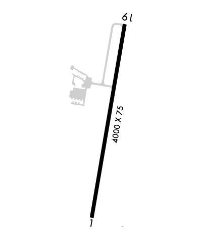
| Lat: N 3050.6 Long: W 08536.1 Elev: 86 Var: +03 Longest Runway: 5398 | ||
| CTAF: 122.72 | ||
| ||||||||||||||||||||||||||||||||||||||||||||
| ||||||||||||||||||||||||||||||||||||||||||||
| Rwy | Rwy | |||||||
| 5398x75 | 5398' | 5398x75 | 5398' | |||||
| Runway ID | Single Wheel | Double Wheel | Double Tandem Wheel | Dual Double Wheel |
| 01/19 | 30,000 | N/A | N/A | N/A |
| These numbers are Advisory and are not limits. The Airport Manager should have more accurate Weight Limits | ||||
 Airport Diagram might not be current. | |
| Facility Name: | TRI-COUNTY |
| City Name: | BONIFAY |
| County: | HOLMES |
| State abbrev: | FL |
| State Name: | FLORIDA |
| Ownership: | PUBLICLY OWNED |
| Use: | OPEN TO THE PUBLIC |
| Owner's Name: | TRI COUNTY AIRPORT AUTHORITY |
| Address: | PO BOX 756 |
| BONIFAY, FL 32425 | |
| Owner's Phone: | (850) 547-6519 |
| Manager's Name: | MARK WILSON |
| Address: | 1983 TRI COUNTY AIRPORT RD |
| BONIFAY, FL 32425 | |
| Phone: | (850) 281-2239 |
| FAA Region: | SOUTHERN |
| FAA Field Office: | ORL |
| Date | Sunrise | Sunset |
|---|---|---|
| 09/24/21 Friday | 6:32 | 18:37 |
| 09/25/21 Saturday | 6:32 | 18:35 |
| 09/26/21 Sunday | 6:33 | 18:34 |
| 09/27/21 Monday | 6:33 | 18:33 |
| 09/28/21 Tuesday | 6:34 | 18:32 |
| 09/29/21 Wednesday | 6:35 | 18:30 |
| 09/30/21 Thursday | 6:35 | 18:29 |
| 10/01/21 Friday | 6:36 | 18:28 |
| 10/02/21 Saturday | 6:36 | 18:27 |
| 10/03/21 Sunday | 6:37 | 18:25 |
| 10/04/21 Monday | 6:38 | 18:24 |
| 10/05/21 Tuesday | 6:38 | 18:23 |
| 10/06/21 Wednesday | 6:39 | 18:22 |
| 10/07/21 Thursday | 6:40 | 18:21 |
| Airport Attendance Schedule | MON-FRI 0830-1630 |
| Airport Status | OPERATIONAL (This Status can change at any time - please check NOTAMS) |
| Airport Lighting Schedule | ACTVT PAPI RWY 01 & 19; MIRL RWY 01/19 - CTAF. |
| Airport Storage Available | Tie Downs, Hanger |
| Extra Services Available | Crop Dusting, Flight Instruction, Aircraft Rental |
| Wind Indicator | YES - (lighted) |
| Control Tower | NO |
| CTAF Frequency | 122.725 |
| Unicom Frequency | 122.725 |
| Rotating Beacon Color | CLEAR-GREEN (Light Land Airport) |
| Segmented Circle | YES |
| Landing Fee | NO |
| Airport Inspected | STATE - performed by STATE AERONAUTICAL PERSONNEL |
| Inspection Date | 03/08/2018 |
| Type of Fuel Available | Grade 100LL, JET A (freeze point -40C); -10SELF SVC FUEL AVBL. |
| Airframe Repair Service | MINOR |
| Power Plant Repair Service | MINOR |
| Latitude | N3050.6 |
| Longitude | W08536.1 (ESTIMATED) |
| Arpt Elevation | 86ft (SURVEYED) |
| Magnetic Variation | 03W |
| 6 miles NE | of BONIFAY |
| Traffic Pattern Altitude | |
| Sectional Chart | NEW ORLEANS |
| Operations (Reported) | Yearly | Avg. Daily |
|---|---|---|
| General Aviation Transient | 7072 | 19 |
| General Aviation Local | 1200 | 3 |
| Air Taxi | 104 | 0 |
| Commerical | 0 | 0 |
| Commuter | 0 | 0 |
| Military | 20000 | 55 |
| Aircraft based on Field | |
|---|---|
| General Aviation Singles | 28 |
| General Aviation Multi | 6 |
| Jet Aircraft | 0 |
| General Aviation Helicopters | 0 |
| Military Aircraft | 0 |
| Gliders | 0 |
| Ultralights | 0 |
| FSS on field | NO |
| FSS tie-in | GAINESVILLE |
| FSS Phone | 1-800-WX-BRIEF |
| Who issues Notams | GNV |
| Notam D service at airport | YES |
| ARTCC Name | JACKSONVILLE |
| Airport Certification | |
| Aircraft Rescue & Firefighting Index | None |
| Airport of Entry | No |
| Custom Landing Rights | No |
| Joint Civil/Military | No |
| Military Landing rights | YES |
| NATIONAL PLAN OF INTEGRATED AIRPORT SYSTEMS (NPIAS) |
| GRANT AGREEMENTS UNDER FAAP/ADAP/AIP |
| ASSURANCES PURSUANT TO TITLE VI, CIVIL RIGHTS ACT OF 1964 |
| WILDLIFE ON RWY; MIL OPS DALGT HR. |
| FOR CD CTC CAIRNS APCH AT 334-255-8402, WHEN APCH CLSD CTC JACKSONVILLE ARTCC AT 904-845-1592. |
| EXTSV SKYDIVING OPS ON WKENDS. |
| RWY 01/1 9 RWY SAFETY AREA CONTAINS MULT WASHOUTS WI FIRST 1000 FT BOTH SIDES. FENCE 252 FT E OF CNTRLN PENETRATES TRSNL SFC. |
| RWY 01 TREES WIDTH OF RWY 252 FT FM RWY END 300 FT E OF CNTRLN PENETRATE TRSNL SFC. |
| RWY 19 HILL 3553-3725 FT AFT APCH END 320-750 FT R OF CNTRLN PENETRATES TRSNL SFC. |
Airport Communications & Frequencies:
| |||||||||||||||||
| Runway: 01 | Runway: 19 | ||
| Mag heading: | 13° | Mag heading: | 193° |
| Rwy Slope: | -.04% Down | Rwy Slope: | .04% Up |
| Approach: | Approach: | ||
| Pattern: | Left Traffic | Pattern: | Left Traffic |
| Markings: | NONPRECISION INSTRUMENT | Markings: | NONPRECISION INSTRUMENT |
| Marking Condition: | GOOD | Marking Condition: | GOOD |
| Arresting Dev: | Arresting Dev: | ||
| Lat & Long: | N3050.2 W08536.2 | Lat. & Long.: | N3051.1 W08536.0 |
| Elev: | 86.0 ft. MSL | Elev: | 84.0 ft. MSL |
| TCH: | 44 ft. AGL | TCH: | 45 ft. AGL |
| Visual Glide Path: | 3.00 degrees | Visual Glide Path: | 3.00 degrees |
| Displaced Threshold: | No | Displaced Threshold: | No |
| Touchdown Zone: | YES | Touchdown Zone: | YES |
| Touchdown Elev.: | 86.0 feet | Touchdown Elev.: | 85.1 feet |
| Visual Glide Slope: | 2-Light PAPI on LEFT side of Runway | Visual Glide Slope: | 2-Light PAPI on LEFT side of Runway |
| RVR Equipment: | RVR Equipment: | ||
| RVV Equipment: | NO | RVV Equipment: | NO |
| Approach Lights: | Approach Lights: | ||
| REIL: | NO | REIL: | NO |
| Centerline Lights: | NO | Centerline Lights: | NO |
| Touchdown lights: | NO | Touchdown lights: | NO |
| Runway Category: | Runway with a Visual Approach | Runway Category: | Runway with a Non-precision Approach |
| Declared Distances: | Declared Distances: | ||
| Obstructions: | TREE | Obstructions: | TREES |
| Marked: | NOT Marked/Lighted | Marked: | NOT Marked/Lighted |
| Clearance slope: | 33:1 | Clearance slope: | 19:1 |
| Obstruction height: | 70 feet AGL | Obstruction height: | 60 feet AGL |
| Dist. from runway: | 2575 feet | Dist. from runway: | 1395 feet |
| Centerline offset: | 80 right of centerline | Centerline offset: | 185 feet left of centerline |
| Comments: | Comments: |
Thanks for using FltPlan.com
all rights reserved © 1999-2021 by Flight Plan LLC
