
| MANSFIELD MUNI MANSFIELD MA |
| |
| Lat: N 4200.1 Long: W 07111.9 Elev: 123 Var: +16 Longest Runway: 3500 | ||
| Clr Del: 122.5 RCO CTAF: 123.0 | ||
| ||||||||||||||||||||||||||||||||||||||||||||
| ||||||||||||||||||||||||||||||||||||||||||||
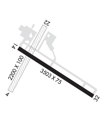
| Rwy | Rwy | |||||||
| 2059x100 | 2059' | 2059x100 | 2059' | |||||
| 3500x75 | 2991' | 3500x75 | 3263' | |||||
| Runway ID | Single Wheel | Double Wheel | Double Tandem Wheel | Dual Double Wheel |
| 04/22 | N/A | N/A | N/A | N/A |
| 14/32 | 26,000 | N/A | N/A | N/A |
| These numbers are Advisory and are not limits. The Airport Manager should have more accurate Weight Limits | ||||
 Airport Diagram might not be current. | |
| Facility Name: | MANSFIELD MUNI |
| City Name: | MANSFIELD |
| County: | BRISTOL |
| State abbrev: | MA |
| State Name: | MASSACHUSETTS |
| Ownership: | PUBLICLY OWNED |
| Use: | OPEN TO THE PUBLIC |
| Owner's Name: | TOWN OF MANSFIELD |
| Address: | TOWN HALL, 6 PARK ROW |
| MANSFIELD, MA 02048 | |
| Owner's Phone: | 508-261-7370 |
| Manager's Name: | KEVIN BULLOCK |
| Address: | 265 FRUIT STREET |
| MANSFIELD, MA 02048 | |
| Phone: | (508) 339-3001; OR 508-339-3001. |
| FAA Region: | NEW ENGLAND |
| FAA Field Office: | NONE |
| Date | Sunrise | Sunset |
|---|---|---|
| 09/24/21 Friday | 6:34 | 18:39 |
| 09/25/21 Saturday | 6:35 | 18:37 |
| 09/26/21 Sunday | 6:36 | 18:36 |
| 09/27/21 Monday | 6:37 | 18:34 |
| 09/28/21 Tuesday | 6:38 | 18:32 |
| 09/29/21 Wednesday | 6:39 | 18:30 |
| 09/30/21 Thursday | 6:40 | 18:29 |
| 10/01/21 Friday | 6:41 | 18:27 |
| 10/02/21 Saturday | 6:42 | 18:25 |
| 10/03/21 Sunday | 6:44 | 18:23 |
| 10/04/21 Monday | 6:45 | 18:22 |
| 10/05/21 Tuesday | 6:46 | 18:20 |
| 10/06/21 Wednesday | 6:47 | 18:18 |
| 10/07/21 Thursday | 6:48 | 18:17 |
| Airport Attendance Schedule | APR-NOV 7 Days A Week 0800-DUSK, DEC-MAR 7 Days A Week 0900-1700 |
| Airport Status | OPERATIONAL (This Status can change at any time - please check NOTAMS) |
| Airport Lighting Schedule | ACTVT MIRL RWY 14/32 - CTAF. |
| Airport Storage Available | Tie Downs |
| Extra Services Available | Flight Instruction |
| Wind Indicator | YES - (unlit) |
| Control Tower | NO |
| CTAF Frequency | 123.000 |
| Unicom Frequency | 123.000 |
| Rotating Beacon Color | CLEAR-GREEN (Light Land Airport) |
| Segmented Circle | NO |
| Landing Fee | NO |
| Airport Inspected | STATE - performed by STATE AERONAUTICAL PERSONNEL |
| Inspection Date | 05/07/2020 |
| Type of Fuel Available | Grade 100LL |
| Airframe Repair Service | MAJOR |
| Power Plant Repair Service | MAJOR |
| Latitude | N4200.1 |
| Longitude | W07111.9 (ESTIMATED) |
| Arpt Elevation | 122ft (SURVEYED) |
| Magnetic Variation | 16W |
| 2 miles SE | of MANSFIELD |
| Traffic Pattern Altitude | |
| Sectional Chart | NEW YORK |
| Operations (Reported) | Yearly | Avg. Daily |
|---|---|---|
| General Aviation Transient | 16000 | 44 |
| General Aviation Local | 20000 | 55 |
| Air Taxi | 750 | 2 |
| Commerical | 0 | 0 |
| Commuter | 0 | 0 |
| Military | 300 | 1 |
| Aircraft based on Field | |
|---|---|
| General Aviation Singles | 42 |
| General Aviation Multi | 2 |
| Jet Aircraft | 0 |
| General Aviation Helicopters | 0 |
| Military Aircraft | 0 |
| Gliders | 1 |
| Ultralights | 0 |
| FSS on field | NO |
| FSS tie-in | BRIDGEPORT |
| FSS Phone | 1-800-WX-BRIEF |
| Who issues Notams | BDR |
| Notam D service at airport | YES |
| ARTCC Name | BOSTON |
| Airport Certification | |
| Aircraft Rescue & Firefighting Index | None |
| Airport of Entry | No |
| Custom Landing Rights | No |
| Joint Civil/Military | No |
| Military Landing rights | YES |
| NATIONAL PLAN OF INTEGRATED AIRPORT SYSTEMS (NPIAS) |
| GRANT AGREEMENTS UNDER FAAP/ADAP/AIP |
| SURPLUS PROPERTY AGREEMENT UNDER PUBLIC LAW 289 |
| ASSURANCES PURSUANT TO TITLE VI, CIVIL RIGHTS ACT OF 1964 |
| TURF STRIP CLSD WINTER MONTHS & AFTER HEAVY RAINS. |
| DEER ON AND INVOF ARPT. |
| ON DEP RWY 32 TURN LEFT TO 290 DEGS. |
| ON DEP RWY 14 NO LEFT TURNS TIL 824 FT MSL. |
| NO TGLS 2100-0800. |
| NO RIGHT TURNS ON DEP FM RWY 32 TIL 1000 FT MSL. |
Airport Communications & Frequencies:
| |||||||||||||||
| Runway: 04 | Runway: 22 | ||
| Mag heading: | 44° | Mag heading: | 224° |
| Rwy Slope: | .30% Up | Rwy Slope: | -.30% Down |
| Approach: | Approach: | ||
| Pattern: | Left Traffic | Pattern: | Left Traffic |
| Markings: | NONE | Markings: | NONE |
| Marking Condition: | Marking Condition: | ||
| Arresting Dev: | Arresting Dev: | ||
| Lat & Long: | N4200.0 W07112.1 | Lat. & Long.: | N4200.3 W07111.9 |
| Elev: | 116.8 ft. MSL | Elev: | 122.9 ft. MSL |
| TCH: | TCH: | ||
| Visual Glide Path: | Visual Glide Path: | ||
| Displaced Threshold: | No | Displaced Threshold: | No |
| Touchdown Zone: | YES | Touchdown Zone: | YES |
| Touchdown Elev.: | 122.9 feet | Touchdown Elev.: | 122.9 feet |
| Visual Glide Slope: | Visual Glide Slope: | ||
| RVR Equipment: | RVR Equipment: | ||
| RVV Equipment: | NO | RVV Equipment: | NO |
| Approach Lights: | Approach Lights: | ||
| REIL: | NO | REIL: | NO |
| Centerline Lights: | NO | Centerline Lights: | NO |
| Touchdown lights: | NO | Touchdown lights: | NO |
| Runway Category: | Runway with a Visual Approach | Runway Category: | Runway with a Visual Approach |
| Declared Distances: | Declared Distances: | ||
| Obstructions: | TREES | Obstructions: | TREES |
| Marked: | NOT Marked/Lighted | Marked: | NOT Marked/Lighted |
| Clearance slope: | 20:1 | Clearance slope: | 6:1 |
| Obstruction height: | 42 feet AGL | Obstruction height: | 100 feet AGL |
| Dist. from runway: | 830 feet | Dist. from runway: | 600 feet |
| Centerline offset: | Centerline offset: | 40 | |
| Comments: | Comments: |
| Runway: 14 | Runway: 32 | ||
| Mag heading: | 139° | Mag heading: | 319° |
| Rwy Slope: | -.07% Down | Rwy Slope: | .07% Up |
| Approach: | Approach: | ||
| Pattern: | Left Traffic | Pattern: | Left Traffic |
| Markings: | BASIC | Markings: | NONPRECISION INSTRUMENT |
| Marking Condition: | GOOD | Marking Condition: | GOOD |
| Arresting Dev: | Arresting Dev: | ||
| Lat & Long: | N4200.2 W07112.1 | Lat. & Long.: | N4159.8 W07111.5 |
| Elev: | 121.4 ft. MSL | Elev: | 119.0 ft. MSL |
| TCH: | TCH: | 38 ft. AGL | |
| Visual Glide Path: | Visual Glide Path: | 4.00 degrees | |
| Displaced Threshold: | 509 feet | Displaced Threshold: | 237 feet |
| Touchdown Zone: | YES | Touchdown Zone: | YES |
| Touchdown Elev.: | 120.6 feet | Touchdown Elev.: | 121.0 feet |
| Visual Glide Slope: | Visual Glide Slope: | 4-Light PAPI on LEFT side of Runway | |
| RVR Equipment: | RVR Equipment: | ||
| RVV Equipment: | NO | RVV Equipment: | NO |
| Approach Lights: | Approach Lights: | ||
| REIL: | NO | REIL: | NO |
| Centerline Lights: | NO | Centerline Lights: | NO |
| Touchdown lights: | NO | Touchdown lights: | NO |
| Runway Category: | Runway with a Visual Approach | Runway Category: | Runway with a Non-precision Approach |
| Declared Distances: | Declared Distances: | ||
| Obstructions: | TREES | Obstructions: | TREES |
| Marked: | NOT Marked/Lighted | Marked: | NOT Marked/Lighted |
| Clearance slope: | 20:1; RWY 14 APCH RATIO 34:1 TO DSPLCD THR. | Clearance slope: | 12:1; RWY 32 APCH RATIO 34:1 TO DSPLCD THR. |
| Obstruction height: | 50 feet AGL | Obstruction height: | 50 feet AGL |
| Dist. from runway: | 1200 feet | Dist. from runway: | 800 feet |
| Centerline offset: | Centerline offset: | 125 feet right of centerline | |
| Comments: | Comments: |
Thanks for using FltPlan.com
all rights reserved © 1999-2021 by Flight Plan LLC
