
| JEKYLL ISLAND JEKYLL ISLAND GA |
| |
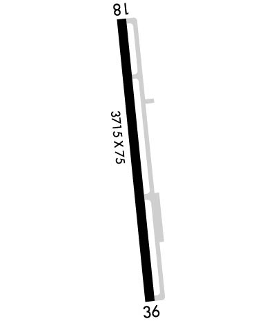
| Lat: N 3104.5 Long: W 08125.7 Elev: 11 Var: +05 Longest Runway: 3715 | ||
| CTAF: 123.05 | ||
| |||||||||||||||||||||||||||||||||||||||||||||||||||||||||||||||||||||
| |||||||||||||||||||||||||||||||||||||||||||||||||||||||||||||||||||||
| Rwy | Rwy | |||||||
| 3715x75 | 3715' | 3715x75 | 3715' | |||||
| Runway ID | Single Wheel | Double Wheel | Double Tandem Wheel | Dual Double Wheel |
| 18/36 | 20,000 | N/A | N/A | N/A |
| These numbers are Advisory and are not limits. The Airport Manager should have more accurate Weight Limits | ||||
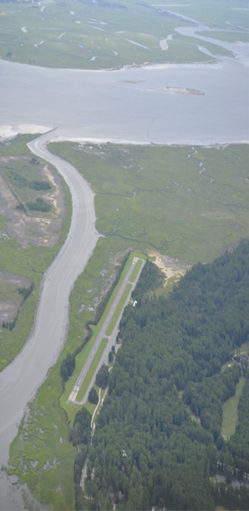
 Airport Diagram might not be current. | |
| Facility Name: | JEKYLL ISLAND |
| City Name: | JEKYLL ISLAND |
| County: | GLYNN |
| State abbrev: | GA |
| State Name: | GEORGIA |
| Ownership: | PUBLICLY OWNED |
| Use: | OPEN TO THE PUBLIC |
| Owner's Name: | JEKYLL ISLAND AUTHORITY |
| Address: | 100 JAMES RD. |
| JEKYLL ISLAND, GA 31527 | |
| Owner's Phone: | 912-635-4000 |
| Manager's Name: | NOEL JENSEN; JEKYLL ISLAND AUTHORITY. |
| Address: | 100 JAMES ROAD |
| JEKYLL ISLAND, GA 31527 | |
| Phone: | 912-635-9330 |
| FAA Region: | SOUTHERN |
| FAA Field Office: | ATL |
| Date | Sunrise | Sunset |
|---|---|---|
| 09/24/21 Friday | 7:15 | 19:20 |
| 09/25/21 Saturday | 7:16 | 19:19 |
| 09/26/21 Sunday | 7:16 | 19:17 |
| 09/27/21 Monday | 7:17 | 19:16 |
| 09/28/21 Tuesday | 7:17 | 19:15 |
| 09/29/21 Wednesday | 7:18 | 19:14 |
| 09/30/21 Thursday | 7:19 | 19:12 |
| 10/01/21 Friday | 7:19 | 19:11 |
| 10/02/21 Saturday | 7:20 | 19:10 |
| 10/03/21 Sunday | 7:20 | 19:09 |
| 10/04/21 Monday | 7:21 | 19:07 |
| 10/05/21 Tuesday | 7:22 | 19:06 |
| 10/06/21 Wednesday | 7:22 | 19:05 |
| 10/07/21 Thursday | 7:23 | 19:04 |
| Airport Attendance Schedule | 7 Days A Week 0900-1600 |
| Airport Status | OPERATIONAL (This Status can change at any time - please check NOTAMS) |
| Airport Lighting Schedule | ACTVT MIRL RY 18/36 AND PAPI RY 18 & RY 36 - CTAF. |
| Airport Storage Available | Tie Downs |
| Extra Services Available | NONE |
| Wind Indicator | YES - (lighted) |
| Control Tower | NO |
| CTAF Frequency | 123.050 |
| Unicom Frequency | 123.050 |
| Rotating Beacon Color | CLEAR-GREEN (Light Land Airport) |
| Segmented Circle | YES |
| Landing Fee | NO |
| Airport Inspected | STATE - performed by STATE AERONAUTICAL PERSONNEL |
| Inspection Date | 12/28/2020 |
| Type of Fuel Available | Grade 100LL |
| Airframe Repair Service | NONE |
| Power Plant Repair Service | NONE |
| Latitude | N3104.5 |
| Longitude | W08125.7 (ESTIMATED) |
| Arpt Elevation | 11ft (SURVEYED) |
| Magnetic Variation | 05W |
| 6 miles SE | of JEKYLL ISLAND |
| Traffic Pattern Altitude | |
| Sectional Chart | JACKSONVILLE |
| Operations (Reported) | Yearly | Avg. Daily |
|---|---|---|
| General Aviation Transient | 26040 | 71 |
| General Aviation Local | 1000 | 3 |
| Air Taxi | 0 | 0 |
| Commerical | 0 | 0 |
| Commuter | 0 | 0 |
| Military | 0 | 0 |
| Aircraft based on Field | |
|---|---|
| General Aviation Singles | 6 |
| General Aviation Multi | 0 |
| Jet Aircraft | 0 |
| General Aviation Helicopters | 0 |
| Military Aircraft | 0 |
| Gliders | 0 |
| Ultralights | 2 |
| FSS on field | NO |
| FSS tie-in | MACON |
| FSS Phone | 1-800-WX-BRIEF |
| Who issues Notams | MCN |
| Notam D service at airport | YES |
| ARTCC Name | JACKSONVILLE |
| Airport Certification | |
| Aircraft Rescue & Firefighting Index | None |
| Airport of Entry | No |
| Custom Landing Rights | No |
| Joint Civil/Military | No |
| Military Landing rights | YES |
| NATIONAL PLAN OF INTEGRATED AIRPORT SYSTEMS (NPIAS) |
| GRANT AGREEMENTS UNDER FAAP/ADAP/AIP |
| ASSURANCES PURSUANT TO TITLE VI, CIVIL RIGHTS ACT OF 1964 |
| TRANSITION VIOLATIONS - 55 FT TREES E OF RY & 40 FT TREES W OF RY. |
| ROTG BCN IS LCTD ON TOP OF A WATER TANK 1/2 - 1 MILE NE OF RY 18 IN A SWAMPY AREA. |
| DEER ON & INVOF OF ARPT. |
| FOR CD CTC JACKSONVILLE ARTCC AT 904-845-1592. |
Airport Communications & Frequencies:
| |||||||||
| Runway: 18 | Runway: 36 | ||
| Mag heading: | 179° | Mag heading: | 359° |
| Rwy Slope: | .00% | Rwy Slope: | .00% |
| Approach: | Approach: | ||
| Pattern: | Right Traffic | Pattern: | Left Traffic |
| Markings: | NONPRECISION INSTRUMENT | Markings: | NONPRECISION INSTRUMENT |
| Marking Condition: | GOOD | Marking Condition: | GOOD |
| Arresting Dev: | Arresting Dev: | ||
| Lat & Long: | N3104.8 W08125.7 | Lat. & Long.: | N3104.2 W08125.6 |
| Elev: | 11.0 ft. MSL | Elev: | 11.0 ft. MSL |
| TCH: | 20 ft. AGL | TCH: | 22 ft. AGL |
| Visual Glide Path: | 3.00 degrees | Visual Glide Path: | 3.25 degrees |
| Displaced Threshold: | No | Displaced Threshold: | No |
| Touchdown Zone: | YES | Touchdown Zone: | YES |
| Touchdown Elev.: | 11.3 feet | Touchdown Elev.: | 11.3 feet |
| Visual Glide Slope: | 2-Light PAPI on LEFT side of Runway | Visual Glide Slope: | 2-Light PAPI on LEFT side of Runway |
| RVR Equipment: | RVR Equipment: | ||
| RVV Equipment: | NO | RVV Equipment: | NO |
| Approach Lights: | Approach Lights: | ||
| REIL: | NO | REIL: | NO |
| Centerline Lights: | NO | Centerline Lights: | NO |
| Touchdown lights: | NO | Touchdown lights: | NO |
| Runway Category: | Runway with a Non-precision Approach | Runway Category: | Runway with a Non-precision Approach |
| Declared Distances: | TORA:3715' TODA:3715' ASDA:3575' LDA:3575' | Declared Distances: | TORA:3715' TODA:3715' ASDA:3715' LDA:3575' |
| Obstructions: | Obstructions: | TREES | |
| Marked: | Marked: | LIGHTED | |
| Clearance slope: | 50:1 | Clearance slope: | |
| Obstruction height: | Obstruction height: | 54 feet AGL | |
| Dist. from runway: | Dist. from runway: | 201 feet | |
| Centerline offset: | Centerline offset: | 230 feet right of centerline | |
| Comments: | Comments: |
Thanks for using FltPlan.com
all rights reserved © 1999-2021 by Flight Plan LLC


