
| FOX STEPHENS FIELD GILMER TX |
| |
| Lat: N 3241.9 Long: W 09456.9 Elev: 415 Var: -03 Longest Runway: 3998 | ||
| AWOS: 118.2 CTAF: 122.9 | ||
| ||||||||||||||||||||||||||||||||||||||||||||
| ||||||||||||||||||||||||||||||||||||||||||||
| ||||||||||||||||||||||||||||||||||||||||||||
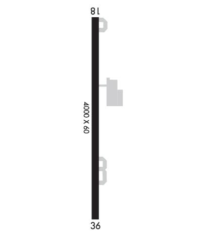
| Rwy | Rwy | |||||||
| 3998x60 | 3998' | 3998x60 | 3998' | |||||
| Runway ID | Single Wheel | Double Wheel | Double Tandem Wheel | Dual Double Wheel |
| 18/36 | 12,000 | N/A | N/A | N/A |
| These numbers are Advisory and are not limits. The Airport Manager should have more accurate Weight Limits | ||||
 Airport Diagram might not be current. | |
| Facility Name: | FOX STEPHENS FLD - GILMER MUNI |
| City Name: | GILMER |
| County: | UPSHUR |
| State abbrev: | TX |
| State Name: | TEXAS |
| Ownership: | PUBLICLY OWNED |
| Use: | OPEN TO THE PUBLIC |
| Owner's Name: | CITY OF GILMER |
| Address: | PO BOX 760 |
| GILMER, TX 75644 | |
| Owner's Phone: | 903-843-2552 |
| Manager's Name: | FRED LAWTON; JEFF ELLINGTON, CITY MGR, 903-843-2552. |
| Address: | PO BOX 760 |
| GILMER, TX 75644 | |
| Phone: | 903-843-8209 |
| FAA Region: | SOUTHWEST |
| FAA Field Office: | TEX |

| Date | Sunrise | Sunset |
|---|---|---|
| 09/24/21 Friday | 7:09 | 19:14 |
| 09/25/21 Saturday | 7:10 | 19:13 |
| 09/26/21 Sunday | 7:10 | 19:11 |
| 09/27/21 Monday | 7:11 | 19:10 |
| 09/28/21 Tuesday | 7:12 | 19:09 |
| 09/29/21 Wednesday | 7:12 | 19:07 |
| 09/30/21 Thursday | 7:13 | 19:06 |
| 10/01/21 Friday | 7:14 | 19:05 |
| 10/02/21 Saturday | 7:14 | 19:03 |
| 10/03/21 Sunday | 7:15 | 19:02 |
| 10/04/21 Monday | 7:16 | 19:01 |
| 10/05/21 Tuesday | 7:16 | 18:59 |
| 10/06/21 Wednesday | 7:17 | 18:58 |
| 10/07/21 Thursday | 7:18 | 18:57 |
| Airport Attendance Schedule | MON-FRI 0700-1700 |
| Airport Status | OPERATIONAL (This Status can change at any time - please check NOTAMS) |
| Airport Lighting Schedule | SS-SR |
| Airport Storage Available | Tie Downs, Hanger |
| Extra Services Available | NONE |
| Wind Indicator | YES - (lighted) |
| Control Tower | NO |
| CTAF Frequency | 122.900 |
| Unicom Frequency | |
| Rotating Beacon Color | CLEAR-GREEN (Light Land Airport) |
| Segmented Circle | YES |
| Landing Fee | NO |
| Airport Inspected | STATE - performed by STATE AERONAUTICAL PERSONNEL |
| Inspection Date | 01/14/2020 |
| Type of Fuel Available | Grade 100LL, JET A (freeze point -40C); -A FULL SVC AVBL FM 8:30 AM - 5:00 PM, MON - FRI. |
| Airframe Repair Service | MAJOR |
| Power Plant Repair Service | MAJOR |
| Latitude | N3241.9 |
| Longitude | W09456.9 (ESTIMATED) |
| Arpt Elevation | 415ft (SURVEYED) |
| Magnetic Variation | 03E |
| 2 miles S | of GILMER |
| Traffic Pattern Altitude | |
| Sectional Chart | MEMPHIS |
| Operations (Reported) | Yearly | Avg. Daily |
|---|---|---|
| General Aviation Transient | 4400 | 12 |
| General Aviation Local | 13200 | 36 |
| Air Taxi | 0 | 0 |
| Commerical | 0 | 0 |
| Commuter | 0 | 0 |
| Military | 0 | 0 |
| Aircraft based on Field | |
|---|---|
| General Aviation Singles | 29; THIS AIRPORT DID NOT REPORT THE N-NUMBERS FOR BASED AIRCRAFT. |
| General Aviation Multi | 4 |
| Jet Aircraft | 0 |
| General Aviation Helicopters | 0 |
| Military Aircraft | 0 |
| Gliders | 0 |
| Ultralights | 0 |
| FSS on field | NO |
| FSS tie-in | FORT WORTH |
| FSS Phone | 1-800-WX-BRIEF |
| Who issues Notams | JXI |
| Notam D service at airport | YES |
| ARTCC Name | FORT WORTH |
| Airport Certification | |
| Aircraft Rescue & Firefighting Index | None |
| Airport of Entry | No |
| Custom Landing Rights | No |
| Joint Civil/Military | No |
| Military Landing rights | YES |
| NATIONAL PLAN OF INTEGRATED AIRPORT SYSTEMS (NPIAS) |
| GRANT AGREEMENTS UNDER FAAP/ADAP/AIP |
| ASSURANCES PURSUANT TO TITLE VI, CIVIL RIGHTS ACT OF 1964 |
| FOR CD CTC FORT WORTH ARTCC AT 817-858-7584. |
Airport Communications & Frequencies:
| |||||||||||||||
| Runway: 18 | Runway: 36 | ||
| Mag heading: | 177° | Mag heading: | 357° |
| Rwy Slope: | -.06% Down | Rwy Slope: | .06% Up |
| Approach: | Approach: | ||
| Pattern: | Left Traffic | Pattern: | Left Traffic |
| Markings: | BASIC | Markings: | BASIC |
| Marking Condition: | FAIR | Marking Condition: | FAIR |
| Arresting Dev: | Arresting Dev: | ||
| Lat & Long: | N3242.2 W09456.9 | Lat. & Long.: | N3241.6 W09456.9 |
| Elev: | 415.1 ft. MSL | Elev: | 412.6 ft. MSL |
| TCH: | 32 ft. AGL | TCH: | |
| Visual Glide Path: | 3.75 degrees | Visual Glide Path: | |
| Displaced Threshold: | No | Displaced Threshold: | No |
| Touchdown Zone: | YES | Touchdown Zone: | YES |
| Touchdown Elev.: | 415.4 feet | Touchdown Elev.: | 412.6 feet |
| Visual Glide Slope: | 2-Light PAPI on LEFT side of Runway | Visual Glide Slope: | |
| RVR Equipment: | RVR Equipment: | ||
| RVV Equipment: | NO | RVV Equipment: | NO |
| Approach Lights: | Approach Lights: | ||
| REIL: | NO | REIL: | NO |
| Centerline Lights: | NO | Centerline Lights: | NO |
| Touchdown lights: | NO | Touchdown lights: | NO |
| Runway Category: | Runway with a Non-precision Approach | Runway Category: | Runway with a Non-precision Approach |
| Declared Distances: | Declared Distances: | ||
| Obstructions: | PLINE | Obstructions: | TREES |
| Marked: | MARKED | Marked: | NOT Marked/Lighted |
| Clearance slope: | 25:1 | Clearance slope: | |
| Obstruction height: | 35 feet AGL | Obstruction height: | 50 feet AGL |
| Dist. from runway: | 1075 feet | Dist. from runway: | 200 feet |
| Centerline offset: | Centerline offset: | 159 feet left of centerline | |
| Comments: | +85 FT TREES AT THR TO 197 FT FM THR, 173 FT RIGHT. | Comments: | +50 FT TREES AT THR TO 200 FT FM THR, 159 FT LEFT. |
Thanks for using FltPlan.com
all rights reserved © 1999-2021 by Flight Plan LLC