
| WESTOVER FIELD AMADOR COUNTY JACKSON CA |
| |
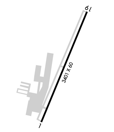
| Lat: N 3822.6 Long: W 12047.6 Elev: 1693 Var: -16 Longest Runway: 3401 | ||
| AWOS: 121.12 CTAF: 123.07 | ||
| |||||||||||||||||||||||
| |||||||||||||||||||||||
| |||||||||||||||||||||||
| Rwy | Rwy | |||||||
| 3401x60 | 3401' | 3401x60 | 3401' | |||||
| Runway ID | Single Wheel | Double Wheel | Double Tandem Wheel | Dual Double Wheel |
| 01/19 | 12,500 | N/A | N/A | N/A |
| H1 | N/A | N/A | N/A | N/A |
| These numbers are Advisory and are not limits. The Airport Manager should have more accurate Weight Limits | ||||
 Airport Diagram might not be current. | |
| Facility Name: | WESTOVER FLD AMADOR COUNTY |
| City Name: | JACKSON |
| County: | AMADOR |
| State abbrev: | CA |
| State Name: | CALIFORNIA |
| Ownership: | PUBLICLY OWNED |
| Use: | OPEN TO THE PUBLIC |
| Owner's Name: | COUNTY OF AMADOR |
| Address: | 12200 AIRPORT RD |
| JACKSON, CA 95642-9527 | |
| Owner's Phone: | 209-223-6376 |
| Manager's Name: | DAVE SHEPPARD |
| Address: | 12200 AIRPORT RD |
| JACKSON, CA 95642 | |
| Phone: | 209-223-6376 |
| FAA Region: | WESTERN-PACIFIC |
| FAA Field Office: | SFO |

| Date | Sunrise | Sunset |
|---|---|---|
| 04/18/26 Saturday | 6:23 | 19:42 |
| 04/19/26 Sunday | 6:22 | 19:43 |
| 04/20/26 Monday | 6:21 | 19:44 |
| 04/21/26 Tuesday | 6:19 | 19:45 |
| 04/22/26 Wednesday | 6:18 | 19:46 |
| 04/23/26 Thursday | 6:17 | 19:47 |
| 04/24/26 Friday | 6:15 | 19:48 |
| 04/25/26 Saturday | 6:14 | 19:49 |
| 04/26/26 Sunday | 6:13 | 19:50 |
| 04/27/26 Monday | 6:11 | 19:51 |
| 04/28/26 Tuesday | 6:10 | 19:52 |
| 04/29/26 Wednesday | 6:09 | 19:53 |
| 04/30/26 Thursday | 6:08 | 19:54 |
| 05/01/26 Friday | 6:06 | 19:55 |
| Airport Attendance Schedule | MON-FRI 0800-1700 |
| Airport Status | OPERATIONAL (This Status can change at any time - please check NOTAMS) |
| Airport Lighting Schedule | ACTVT REIL RWY 01 & 19; PAPI RWY 01 & 19; MIRL RWY 01/19; TWY LGTS SS-SR ONLY - CTAF. |
| Airport Storage Available | Tie Downs |
| Extra Services Available | NONE |
| Wind Indicator | YES - (lighted) |
| Control Tower | NO |
| CTAF Frequency | 123.075 |
| Unicom Frequency | 123.075 |
| Rotating Beacon Color | WG |
| Segmented Circle | YES |
| Landing Fee | NO |
| Airport Inspected | STATE - performed by STATE AERONAUTICAL PERSONNEL |
| Inspection Date | 07/17/2025 |
| Type of Fuel Available | Grade 100LL, JET A (freeze point -40C) |
| Airframe Repair Service | NONE |
| Power Plant Repair Service | NONE |
| Latitude | N3822.6 |
| Longitude | W12047.6 (ESTIMATED) |
| Arpt Elevation | 1693ft (ESTIMATED) |
| Magnetic Variation | 16E |
| 2 miles NW | of JACKSON |
| Traffic Pattern Altitude | |
| Sectional Chart | SAN FRANCISCO |
| Operations (Reported) | Yearly | Avg. Daily |
|---|---|---|
| General Aviation Transient | 0 | 0 |
| General Aviation Local | 0 | 0 |
| Air Taxi | 0 | 0 |
| Commerical | 0 | 0 |
| Commuter | 0 | 0 |
| Military | 0 | 0 |
| Aircraft based on Field | |
|---|---|
| General Aviation Singles | 0 |
| General Aviation Multi | 0 |
| Jet Aircraft | 0 |
| General Aviation Helicopters | 0 |
| Military Aircraft | 0 |
| Gliders | 0 |
| Ultralights | 0 |
| FSS on field | NO |
| FSS tie-in | RANCHO MURIETA |
| FSS Phone | 1-800-WX-BRIEF |
| Who issues Notams | RIU |
| Notam D service at airport | YES |
| ARTCC Name | OAKLAND |
| Airport Certification | |
| Aircraft Rescue & Firefighting Index | None |
| Airport of Entry | No |
| Custom Landing Rights | No |
| Joint Civil/Military | No |
| Military Landing rights | YES |
| NATIONAL PLAN OF INTEGRATED AIRPORT SYSTEMS (NPIAS) |
| GRANT AGREEMENTS UNDER FAAP/ADAP/AIP |
| ASSURANCES PURSUANT TO TITLE VI, CIVIL RIGHTS ACT OF 1964 |
| RWY 19 IS PREFERRED RWY. |
| FOR CD CTC NORCAL APCH AT 916-361-6874. |
Airport Communications & Frequencies:
| ||||||||||||||
| Runway: 01 | Runway: 19 | ||
| Mag heading: | 6° | Mag heading: | 186° |
| Rwy Slope: | -.21% Down | Rwy Slope: | .21% Up |
| Approach: | Approach: | ||
| Pattern: | Left Traffic | Pattern: | Left Traffic |
| Markings: | BASIC | Markings: | BASIC |
| Marking Condition: | GOOD | Marking Condition: | GOOD |
| Arresting Dev: | Arresting Dev: | ||
| Lat & Long: | N3822.3 W12047.8 | Lat. & Long.: | N3822.9 W12047.5 |
| Elev: | 1690.8 ft. MSL | Elev: | 1683.8 ft. MSL |
| TCH: | 22 ft. AGL | TCH: | 32 ft. AGL |
| Visual Glide Path: | 3.00 degrees | Visual Glide Path: | 4.00 degrees |
| Displaced Threshold: | No | Displaced Threshold: | No |
| Touchdown Zone: | YES | Touchdown Zone: | YES |
| Touchdown Elev.: | 1693.0 feet | Touchdown Elev.: | 1693.0 feet |
| Visual Glide Slope: | 2-Light PAPI on LEFT side of Runway | Visual Glide Slope: | 2-Light PAPI on LEFT side of Runway; PAPI RWY 19 UNUSBL BYD 5 DEG L OF CRS. |
| RVR Equipment: | RVR Equipment: | ||
| RVV Equipment: | NO | RVV Equipment: | NO |
| Approach Lights: | Approach Lights: | ||
| REIL: | YES | REIL: | YES |
| Centerline Lights: | NO | Centerline Lights: | NO |
| Touchdown lights: | NO | Touchdown lights: | NO |
| Runway Category: | Runway with a Non-precision Approach | Runway Category: | Runway with a Visual Approach |
| Declared Distances: | Declared Distances: | ||
| Obstructions: | Obstructions: | TREE | |
| Marked: | Marked: | NOT Marked/Lighted | |
| Clearance slope: | 50:1 | Clearance slope: | 18:1 |
| Obstruction height: | Obstruction height: | 75 feet AGL | |
| Dist. from runway: | Dist. from runway: | 1600 feet | |
| Centerline offset: | Centerline offset: | 250 feet left of centerline | |
| Comments: | Comments: |
Thanks for using FltPlan.com
all rights reserved © 1999-2026 by Flight Plan LLC
