| SMITH REYNOLDS WINSTON SALEM NC |
| |
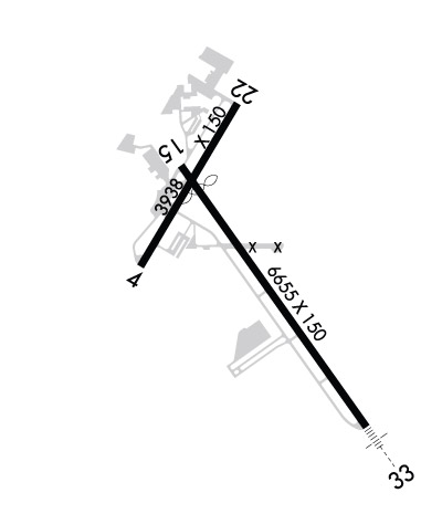
| Lat: N 3608.0 Long: W 08013.3 Elev: 969 Var: +07 Longest Runway: 6655 | ||
| Dept. ATIS: 121.3 Arr. ATIS: 121.3 Ground: 128.25 Tower: 123.75 | ||
| ||||||||||||||||||||||||||||||||||||||||||||
| ||||||||||||||||||||||||||||||||||||||||||||
| ||||||||||||||||||||||||||||||||||||||||||||
| FBOs at nearby airports who want your business: | |||||||||||||||||
| |||||||||||||||||
| |||||||||||||||||
| Rwy | Rwy | |||||||
| 3938x150 | 3938' | 3938x150 | 3938' | |||||
| 6655x150 | 6070' | 6655x150 | 6655' | 110.30 - 331° | ||||
| Runway ID | Single Wheel | Double Wheel | Double Tandem Wheel | Dual Double Wheel |
| 04/22 | 51,000 | 82,000 | 145,000 | N/A |
| 15/33 | 120,000 | 250,000 | 550,000 | 1,087,000 |
| These numbers are Advisory and are not limits. The Airport Manager should have more accurate Weight Limits | ||||
 Airport Diagram might not be current. | |
| Facility Name: | SMITH REYNOLDS |
| City Name: | WINSTON SALEM |
| County: | FORSYTH |
| State abbrev: | NC |
| State Name: | NORTH CAROLINA |
| Ownership: | PUBLICLY OWNED |
| Use: | OPEN TO THE PUBLIC |
| Owner's Name: | FORSYTH COUNTY |
| Address: | 3801 N LIBERTY ST., STE 204 |
| WINSTON SALEM, NC 27105 | |
| Owner's Phone: | 336-607-6120 |
| Manager's Name: | MARK R. DAVIDSON, A.A.E. |
| Address: | 3801 N. LIBERTY ST., STE 204 |
| WINSTON SALEM, NC 27105 | |
| Phone: | 336-607-6120 |
| FAA Region: | SOUTHERN |
| FAA Field Office: | MEM |
| Date | Sunrise | Sunset |
|---|---|---|
| 06/10/26 Wednesday | 6:03 | 20:37 |
| 06/11/26 Thursday | 6:03 | 20:38 |
| 06/12/26 Friday | 6:03 | 20:38 |
| 06/13/26 Saturday | 6:03 | 20:39 |
| 06/14/26 Sunday | 6:03 | 20:39 |
| 06/15/26 Monday | 6:03 | 20:40 |
| 06/16/26 Tuesday | 6:03 | 20:40 |
| 06/17/26 Wednesday | 6:03 | 20:40 |
| 06/18/26 Thursday | 6:03 | 20:41 |
| 06/19/26 Friday | 6:04 | 20:41 |
| 06/20/26 Saturday | 6:04 | 20:41 |
| 06/21/26 Sunday | 6:04 | 20:41 |
| 06/22/26 Monday | 6:04 | 20:41 |
| 06/23/26 Tuesday | 6:04 | 20:42 |
| Airport Attendance Schedule | CONTINUOUS |
| Airport Status | OPERATIONAL (This Status can change at any time - please check NOTAMS) |
| Airport Lighting Schedule | SS-SR |
| Airport Storage Available | Tie Downs, Hanger |
| Extra Services Available | Air Freight, Avionics, Cargo Handling, Charter, Flight Instruction, Aircraft Rental, Aircraft Sales |
| Wind Indicator | YES - (lighted) |
| Control Tower | YES |
| CTAF Frequency | 123.750 |
| Unicom Frequency | 122.950 |
| Rotating Beacon Color | WG |
| Segmented Circle | YES |
| Landing Fee | NO |
| Airport Inspected | FEDERAL - performed by FAA AIRPORTS FIELD PERSONNEL |
| Inspection Date | 04/16/2025 |
| Type of Fuel Available | Grade 100LL, JET A (freeze point -40C) |
| Airframe Repair Service | MAJOR |
| Power Plant Repair Service | MAJOR |
| Latitude | N3608.0 |
| Longitude | W08013.3 (ESTIMATED) |
| Arpt Elevation | 969ft (SURVEYED) |
| Magnetic Variation | 07W |
| 3 miles NE | of WINSTON SALEM |
| Traffic Pattern Altitude | |
| Sectional Chart | CINCINNATI |
| Operations (Reported) | Yearly | Avg. Daily |
|---|---|---|
| General Aviation Transient | 0 | 0 |
| General Aviation Local | 0 | 0 |
| Air Taxi | 0 | 0 |
| Commerical | 0 | 0 |
| Commuter | 0 | 0 |
| Military | 0 | 0 |
| Aircraft based on Field | |
|---|---|
| General Aviation Singles | 0 |
| General Aviation Multi | 0 |
| Jet Aircraft | 0 |
| General Aviation Helicopters | 0 |
| Military Aircraft | 0 |
| Gliders | 0 |
| Ultralights | 0 |
| FSS on field | NO |
| FSS tie-in | RALEIGH |
| FSS Phone | 1-800-WX-BRIEF |
| Who issues Notams | INT |
| Notam D service at airport | YES |
| ARTCC Name | ATLANTA |
| Airport Certification | ARFF INDEX B COVERAGE AVBL, CALL OPS 336-607-6122. |
| Aircraft Rescue & Firefighting Index | AIRPORT HAS A CERTIFICATE UNDER CFR PART 139 |
| Airport of Entry | No |
| Custom Landing Rights | YES |
| Joint Civil/Military | No |
| Military Landing rights | YES |
| NATIONAL PLAN OF INTEGRATED AIRPORT SYSTEMS (NPIAS) |
| GRANT AGREEMENTS UNDER FAAP/ADAP/AIP |
| SURPLUS PROPERTY AGREEMENT UNDER PUBLIC LAW 289 |
| ASSURANCES PURSUANT TO TITLE VI, CIVIL RIGHTS ACT OF 1964 |
| AGREEMENT UNDER DLAND OR DCLA HAS EXPIRED. |
| FOR CD CTC GREENSBORO APCH AT 743-222-6129. |
| ARPT SFC COND NOT RPRT DLY 1630-0830L, OR ON WKEND AND HOL. |
| RWY 04/2 2 RWY 04/22 NOT AVBL FOR PART 121/PART 380 OPS WITH SKED PAX CARRYING OPS MORE THAN 9 PAX SEATS AND NON-SKED PAX CARRYING OPS MORE THAN 30 PAX SEATS. NO PART 121/PART 380 OPS EXC FOR TAX. |
| RWY 15/3 3 ARRESTING GEAR/SYSTEM: ENGINEERED MATERIALS ARRESTING SYSTEM (EMAS) 304 FT IN LENGTH BY 170 FT WIDTH AT THE DEPARTURE END OF RWY 15. |
| RWY 04/2 2 PCR VALUE: 180/F/B/X/T |
| RWY 15/3 3 PCR VALUE: 1320/F/D/X/T |
Airport Communications & Frequencies:
| ||||||||||||||||||||||||||
| Runway: 04 | Runway: 22 | ||
| Mag heading: | 38° | Mag heading: | 218° |
| Rwy Slope: | .27% Up | Rwy Slope: | -.27% Down |
| Approach: | Approach: | ||
| Pattern: | Left Traffic | Pattern: | Left Traffic |
| Markings: | BASIC | Markings: | BASIC |
| Marking Condition: | GOOD | Marking Condition: | GOOD |
| Arresting Dev: | Arresting Dev: | ||
| Lat & Long: | N3608.0 W08013.7 | Lat. & Long.: | N3608.5 W08013.3 |
| Elev: | 949.7 ft. MSL | Elev: | 960.5 ft. MSL |
| TCH: | TCH: | 39 ft. AGL | |
| Visual Glide Path: | Visual Glide Path: | 3.00 degrees | |
| Displaced Threshold: | No | Displaced Threshold: | No |
| Touchdown Zone: | YES | Touchdown Zone: | YES |
| Touchdown Elev.: | 969.4 feet | Touchdown Elev.: | 969.4 feet |
| Visual Glide Slope: | Visual Glide Slope: | 2-Light PAPI on LEFT side of Runway | |
| RVR Equipment: | RVR Equipment: | ||
| RVV Equipment: | NO | RVV Equipment: | NO |
| Approach Lights: | Approach Lights: | ||
| REIL: | NO | REIL: | NO |
| Centerline Lights: | NO | Centerline Lights: | NO |
| Touchdown lights: | NO | Touchdown lights: | NO |
| Runway Category: | Runway with a Visual Approach | Runway Category: | Runway with a Visual Approach |
| Declared Distances: | TORA:3938' TODA:3938' ASDA:3938' LDA:3938' | Declared Distances: | TORA:3938' TODA:3938' ASDA:3938' LDA:3938' |
| Obstructions: | TREES | Obstructions: | TREES |
| Marked: | NOT Marked/Lighted | Marked: | NOT Marked/Lighted |
| Clearance slope: | 20:1 | Clearance slope: | 24:1 |
| Obstruction height: | 85 feet AGL | Obstruction height: | 50 feet AGL |
| Dist. from runway: | 1700 feet | Dist. from runway: | 1400 feet |
| Centerline offset: | 100 right of centerline | Centerline offset: | 150 feet right of centerline |
| Comments: | Comments: |
| Runway: 15 | Runway: 33 | ||
| Mag heading: | 152° | Mag heading: | 332° |
| Rwy Slope: | -1.02% Down | Rwy Slope: | 1.02% Up |
| Approach: | Approach: | ILS | |
| Pattern: | Left Traffic | Pattern: | Left Traffic |
| Markings: | NONPRECISION INSTRUMENT | Markings: | PRECISION INSTRUMENT |
| Marking Condition: | GOOD | Marking Condition: | GOOD |
| Arresting Dev: | EMAS | Arresting Dev: | |
| Lat & Long: | N3608.3 W08013.6 | Lat. & Long.: | N3607.4 W08012.8 |
| Elev: | 967.7 ft. MSL | Elev: | 900.0 ft. MSL |
| TCH: | 38 ft. AGL | TCH: | 58 ft. AGL |
| Visual Glide Path: | 3.00 degrees | Visual Glide Path: | 3.00 degrees |
| Displaced Threshold: | 585 feet | Displaced Threshold: | No |
| Touchdown Zone: | YES | Touchdown Zone: | YES |
| Touchdown Elev.: | 967.6 feet | Touchdown Elev.: | 940.6 feet |
| Visual Glide Slope: | 4-Light PAPI on LEFT side of Runway | Visual Glide Slope: | 4-Light PAPI on LEFT side of Runway |
| RVR Equipment: | ROLLOUT | RVR Equipment: | TOUCHDOWN |
| RVV Equipment: | NO | RVV Equipment: | NO |
| Approach Lights: | Approach Lights: | MALSR - 1,400 foot medium intensity approach lighting system with runway alignment indicator lights | |
| REIL: | YES | REIL: | NO |
| Centerline Lights: | NO | Centerline Lights: | NO |
| Touchdown lights: | NO | Touchdown lights: | NO |
| Runway Category: | Runway with a Non-precision Approach having visibility minimums greater than 3/4 mile | Runway Category: | Precision Instrument Runway |
| Declared Distances: | TORA:6655' TODA:6655' ASDA:6655' LDA:6069' | Declared Distances: | TORA:6655' TODA:6655' ASDA:6655' LDA:6655' |
| Obstructions: | BLDG | Obstructions: | |
| Marked: | NOT Marked/Lighted | Marked: | |
| Clearance slope: | 18:1; APCH RATIO 32:1 FM DSPLCD THR. | Clearance slope: | 50:1 |
| Obstruction height: | 57 feet AGL | Obstruction height: | |
| Dist. from runway: | 1250 feet | Dist. from runway: | |
| Centerline offset: | 450 left of centerline | Centerline offset: | |
| Comments: | Comments: |
Thanks for using FltPlan.com
all rights reserved © 1999-2026 by Flight Plan LLC