| IMMOKALEE RGNL IMMOKALEE FL |
| |
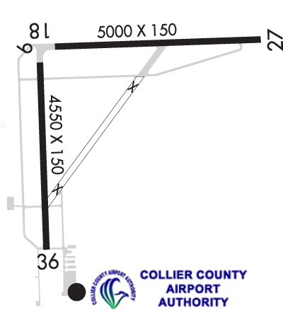
| Lat: N 2626.0 Long: W 08124.0 Elev: 37 Var: +05 Longest Runway: 5000 | ||
| AWOS: 118.52 CTAF: 122.9 | ||
| ||||||||||||||||||||||||||||||||||||||||||||||||||||||||||||||||||||
| ||||||||||||||||||||||||||||||||||||||||||||||||||||||||||||||||||||
| ||||||||||||||||||||||||||||||||||||||||||||||||||||||||||||||||||||
| Rwy | Rwy | |||||||
| 5000x100 | 5000' | 5000x100 | 5000' | |||||
| 4550x150 | 4550' | 4550x150 | 4550' | |||||
| Runway ID | Single Wheel | Double Wheel | Double Tandem Wheel | Dual Double Wheel |
| 09/27 | 68,000 | 97,000 | 110,000 | N/A |
| 18/36 | 27,000 | 42,000 | 90,000 | N/A |
| These numbers are Advisory and are not limits. The Airport Manager should have more accurate Weight Limits | ||||
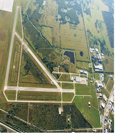
 Airport Diagram might not be current. | |
| Facility Name: | IMMOKALEE RGNL |
| City Name: | IMMOKALEE |
| County: | COLLIER |
| State abbrev: | FL |
| State Name: | FLORIDA |
| Ownership: | PUBLICLY OWNED |
| Use: | OPEN TO THE PUBLIC |
| Owner's Name: | COLLIER COUNTY AIRPORT AUTHORITY |
| Address: | 2005 MAINSAIL DR., SUITE 1 |
| NAPLES, FL 34114 | |
| Owner's Phone: | 239-252-8400 |
| Manager's Name: | BRYANT GARRETT; ALT CTC: SPENCER BRILLON (239) 252-8393 |
| Address: | 165 AIRPARK BLVD |
| IMMOKALEE, FL 34142 | |
| Phone: | 239-252-8425 |
| FAA Region: | SOUTHERN |
| FAA Field Office: | ORL |
| Date | Sunrise | Sunset |
|---|---|---|
| 06/19/26 Friday | 6:33 | 20:21 |
| 06/20/26 Saturday | 6:33 | 20:21 |
| 06/21/26 Sunday | 6:33 | 20:21 |
| 06/22/26 Monday | 6:34 | 20:22 |
| 06/23/26 Tuesday | 6:34 | 20:22 |
| 06/24/26 Wednesday | 6:34 | 20:22 |
| 06/25/26 Thursday | 6:34 | 20:22 |
| 06/26/26 Friday | 6:35 | 20:22 |
| 06/27/26 Saturday | 6:35 | 20:22 |
| 06/28/26 Sunday | 6:35 | 20:22 |
| 06/29/26 Monday | 6:36 | 20:22 |
| 06/30/26 Tuesday | 6:36 | 20:22 |
| 07/01/26 Wednesday | 6:36 | 20:23 |
| 07/02/26 Thursday | 6:37 | 20:23 |
| Airport Attendance Schedule | 7 Days A Week 0800-1800 |
| Airport Status | OPERATIONAL (This Status can change at any time - please check NOTAMS) |
| Airport Lighting Schedule | ACTVT REIL RWY 9, 27, 18, & 36; MIRL RWY 09/27 & 18/36 - CTAF. |
| Airport Storage Available | Tie Downs, Hanger |
| Extra Services Available | Crop Dusting, Charter, Glider |
| Wind Indicator | YES - (lighted) |
| Control Tower | NO |
| CTAF Frequency | 122.900 |
| Unicom Frequency | |
| Rotating Beacon Color | WG |
| Segmented Circle | Y-L |
| Landing Fee | NO |
| Airport Inspected | STATE - performed by STATE AERONAUTICAL PERSONNEL |
| Inspection Date | 10/15/2025 |
| Type of Fuel Available | Grade 100LL, JET A (freeze point -40C), JET A; -10CREDIT CARD FUEL AVBL H24. |
| Airframe Repair Service | MINOR |
| Power Plant Repair Service | MINOR |
| Latitude | N2626.0 |
| Longitude | W08124.0 (ESTIMATED) |
| Arpt Elevation | 37ft (SURVEYED) |
| Magnetic Variation | 05W |
| 1 miles NE | of IMMOKALEE |
| Traffic Pattern Altitude | |
| Sectional Chart | MIAMI |
| Operations (Reported) | Yearly | Avg. Daily |
|---|---|---|
| General Aviation Transient | 0 | 0 |
| General Aviation Local | 0 | 0 |
| Air Taxi | 0 | 0 |
| Commerical | 0 | 0 |
| Commuter | 0 | 0 |
| Military | 0 | 0 |
| Aircraft based on Field | |
|---|---|
| General Aviation Singles | 0 |
| General Aviation Multi | 0 |
| Jet Aircraft | 0 |
| General Aviation Helicopters | 0 |
| Military Aircraft | 0 |
| Gliders | 0 |
| Ultralights | 0 |
| FSS on field | NO |
| FSS tie-in | MIAMI |
| FSS Phone | 1-800-WX-BRIEF |
| Who issues Notams | MIA |
| Notam D service at airport | YES |
| ARTCC Name | MIAMI |
| Airport Certification | |
| Aircraft Rescue & Firefighting Index | None |
| Airport of Entry | No |
| Custom Landing Rights | No |
| Joint Civil/Military | No |
| Military Landing rights | YES |
| NATIONAL PLAN OF INTEGRATED AIRPORT SYSTEMS (NPIAS) |
| GRANT AGREEMENTS UNDER FAAP/ADAP/AIP |
| SURPLUS PROPERTY AGREEMENT UNDER PUBLIC LAW 289 |
| ASSURANCES PURSUANT TO TITLE VI, CIVIL RIGHTS ACT OF 1964 |
| CROP DUSTING ACTVTY DURG DALGT HRS. |
| WILDLIFE, BANNER TOWING & ULTRALIGHT ACTVTY ON AND INVOF ARPT. |
| AFT HR SVC - AMGR. |
| FOR CD CTC FORT MYERS APCH AT 239-416-1026, WHEN APCH CLSD CTC MIAMI ARTCC AT 305-716-1731. |
Airport Communications & Frequencies:
| |||||||||||||||
| Runway: 09 | Runway: 27 | ||
| Mag heading: | 94° | Mag heading: | 274° |
| Rwy Slope: | -.06% Down | Rwy Slope: | .06% Up |
| Approach: | Approach: | ||
| Pattern: | Left Traffic | Pattern: | Left Traffic |
| Markings: | NONPRECISION INSTRUMENT | Markings: | NONPRECISION INSTRUMENT |
| Marking Condition: | FAIR | Marking Condition: | FAIR |
| Arresting Dev: | Arresting Dev: | ||
| Lat & Long: | N2626.2 W08124.2 | Lat. & Long.: | N2626.3 W08123.3 |
| Elev: | 37.1 ft. MSL | Elev: | 34.0 ft. MSL |
| TCH: | 52 ft. AGL | TCH: | 53 ft. AGL |
| Visual Glide Path: | 3.00 degrees | Visual Glide Path: | 3.00 degrees |
| Displaced Threshold: | No | Displaced Threshold: | No |
| Touchdown Zone: | YES | Touchdown Zone: | YES |
| Touchdown Elev.: | 37.1 feet | Touchdown Elev.: | 34.5 feet |
| Visual Glide Slope: | 4-Light PAPI on LEFT side of Runway | Visual Glide Slope: | 4-Light PAPI on LEFT side of Runway |
| RVR Equipment: | RVR Equipment: | ||
| RVV Equipment: | NO | RVV Equipment: | NO |
| Approach Lights: | Approach Lights: | ||
| REIL: | YES | REIL: | YES |
| Centerline Lights: | NO | Centerline Lights: | NO |
| Touchdown lights: | NO | Touchdown lights: | NO |
| Runway Category: | Runway with a Non-precision Approach having visibility minimums greater than 3/4 mile | Runway Category: | Runway with a Non-precision Approach having visibility minimums greater than 3/4 mile |
| Declared Distances: | Declared Distances: | ||
| Obstructions: | TREES | Obstructions: | TREES |
| Marked: | NOT Marked/Lighted | Marked: | NOT Marked/Lighted |
| Clearance slope: | 34:1 | Clearance slope: | 41:1 |
| Obstruction height: | 21 feet AGL | Obstruction height: | 12 feet AGL |
| Dist. from runway: | 920 feet | Dist. from runway: | 695 feet |
| Centerline offset: | 285 left of centerline | Centerline offset: | 250 feet right of centerline |
| Comments: | Comments: |
| Runway: 18 | Runway: 36 | ||
| Mag heading: | 183° | Mag heading: | 3° |
| Rwy Slope: | -.06% Down | Rwy Slope: | .06% Up |
| Approach: | Approach: | ||
| Pattern: | Left Traffic | Pattern: | Left Traffic |
| Markings: | NONPRECISION INSTRUMENT | Markings: | NONPRECISION INSTRUMENT |
| Marking Condition: | GOOD | Marking Condition: | GOOD |
| Arresting Dev: | Arresting Dev: | ||
| Lat & Long: | N2626.2 W08124.3 | Lat. & Long.: | N2625.4 W08124.3 |
| Elev: | 35.9 ft. MSL | Elev: | 33.3 ft. MSL |
| TCH: | 52 ft. AGL | TCH: | 52 ft. AGL |
| Visual Glide Path: | 3.00 degrees | Visual Glide Path: | 3.00 degrees |
| Displaced Threshold: | No | Displaced Threshold: | No |
| Touchdown Zone: | YES | Touchdown Zone: | YES |
| Touchdown Elev.: | 35.9 feet | Touchdown Elev.: | 34.2 feet |
| Visual Glide Slope: | 4-Light PAPI on LEFT side of Runway | Visual Glide Slope: | 4-Light PAPI on LEFT side of Runway |
| RVR Equipment: | RVR Equipment: | ||
| RVV Equipment: | NO | RVV Equipment: | NO |
| Approach Lights: | Approach Lights: | ||
| REIL: | YES | REIL: | YES |
| Centerline Lights: | NO | Centerline Lights: | NO |
| Touchdown lights: | NO | Touchdown lights: | NO |
| Runway Category: | Runway with a Non-precision Approach having visibility minimums greater than 3/4 mile | Runway Category: | Runway with a Non-precision Approach having visibility minimums greater than 3/4 mile |
| Declared Distances: | Declared Distances: | ||
| Obstructions: | TREES | Obstructions: | TREE |
| Marked: | NOT Marked/Lighted | Marked: | NOT Marked/Lighted |
| Clearance slope: | 36:1 | Clearance slope: | 40:1 |
| Obstruction height: | 19 feet AGL | Obstruction height: | 42 feet AGL |
| Dist. from runway: | 900 feet | Dist. from runway: | 1875 feet |
| Centerline offset: | 225 left of centerline | Centerline offset: | 225 feet right of centerline |
| Comments: | Comments: |
Thanks for using FltPlan.com
all rights reserved © 1999-2026 by Flight Plan LLC