| HUTCHINSON MUNI HUTCHINSON KS |
| |
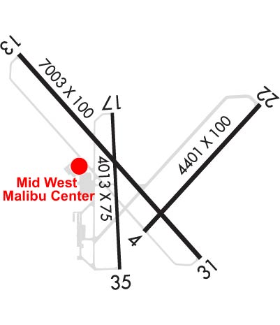
| Lat: N 3804.0 Long: W 09751.6 Elev: 1543 Var: -04 Longest Runway: 7003 | ||
| Dept. ATIS: 124.25 Arr. ATIS: 124.25 Ground: 121.9 Tower: 118.5 | ||
| |||||||||||||||||||||||||||||||||||||||||||||||||||||||||||||
| |||||||||||||||||||||||||||||||||||||||||||||||||||||||||||||
| |||||||||||||||||||||||||||||||||||||||||||||||||||||||||||||
| |||||||||||||||||||||||||||||||||||||||||||||||||||||||||||||
| Rwy | Rwy | |||||||
| 4405x100 | 4405' | 4405x100 | 4405' | |||||
| 7003x100 | 7003' | 110.10 - 134° | 7003x100 | 7003' | ||||
| 4012x75 | 4012' | 4012x75 | 4012' | |||||
| Runway ID | Single Wheel | Double Wheel | Double Tandem Wheel | Dual Double Wheel |
| 04/22 | 42,000 | 52,000 | 76,000 | N/A |
| 13/31 | 44,000 | 58,000 | 103,000 | N/A |
| 17/35 | 43,500 | 58,500 | 76,000 | N/A |
| These numbers are Advisory and are not limits. The Airport Manager should have more accurate Weight Limits | ||||
 Airport Diagram might not be current. | |
| Facility Name: | HUTCHINSON RGNL |
| City Name: | HUTCHINSON |
| County: | RENO |
| State abbrev: | KS |
| State Name: | KANSAS |
| Ownership: | PUBLICLY OWNED |
| Use: | OPEN TO THE PUBLIC |
| Owner's Name: | CITY OF HUTCHINSON |
| Address: | BOX 1567 |
| HUTCHINSON, KS 67504 | |
| Owner's Phone: | 620-694-2611 |
| Manager's Name: | MR. PIETER MILLER |
| Address: | 1100 N. AIRPORT ROAD |
| HUTCHINSON, KS 67504 | |
| Phone: | 620-694-2692 |
| FAA Region: | CENTRAL |
| FAA Field Office: | NONE |
| Date | Sunrise | Sunset |
|---|---|---|
| 09/24/21 Friday | 7:21 | 19:26 |
| 09/25/21 Saturday | 7:22 | 19:24 |
| 09/26/21 Sunday | 7:22 | 19:22 |
| 09/27/21 Monday | 7:23 | 19:21 |
| 09/28/21 Tuesday | 7:24 | 19:19 |
| 09/29/21 Wednesday | 7:25 | 19:18 |
| 09/30/21 Thursday | 7:26 | 19:16 |
| 10/01/21 Friday | 7:27 | 19:15 |
| 10/02/21 Saturday | 7:28 | 19:13 |
| 10/03/21 Sunday | 7:29 | 19:12 |
| 10/04/21 Monday | 7:30 | 19:10 |
| 10/05/21 Tuesday | 7:31 | 19:09 |
| 10/06/21 Wednesday | 7:31 | 19:07 |
| 10/07/21 Thursday | 7:32 | 19:06 |
| Airport Attendance Schedule | MON-FRI 0800-1800, SAT-SUN 0800-1700; ATTENDANT AFT HRS CALL 620-663-1546. |
| Airport Status | OPERATIONAL (This Status can change at any time - please check NOTAMS) |
| Airport Lighting Schedule | ACTVT MALSR RWY 13; PAPI RWY 4, 17, 35; VASI RWY 22; MIRL RWY 04/22 & 17/35; HIRL RWY 13/31 - CTAF. |
| Airport Storage Available | Tie Downs, Hanger |
| Extra Services Available | Air Freight, Charter, Flight Instruction, Aircraft Rental |
| Wind Indicator | YES - (lighted) |
| Control Tower | YES |
| CTAF Frequency | 118.500 |
| Unicom Frequency | 122.950 |
| Rotating Beacon Color | CLEAR-GREEN (Light Land Airport) |
| Segmented Circle | NO |
| Landing Fee | NO |
| Airport Inspected | FEDERAL - performed by STATE AERONAUTICAL PERSONNEL |
| Inspection Date | 07/16/2020 |
| Type of Fuel Available | Grade 100LL, JET A (freeze point -40C); -10SELF SERVICE 100LL FUEL AVBL N OF THE TRANSIENT APRON |
| Airframe Repair Service | MAJOR |
| Power Plant Repair Service | MAJOR |
| Latitude | N3804.0 |
| Longitude | W09751.6 (ESTIMATED) |
| Arpt Elevation | 1542ft (SURVEYED) |
| Magnetic Variation | 04E |
| 3 miles E | of HUTCHINSON |
| Traffic Pattern Altitude | |
| Sectional Chart | WICHITA |
| Operations (Reported) | Yearly | Avg. Daily |
|---|---|---|
| General Aviation Transient | 10508 | 29 |
| General Aviation Local | 17647 | 48 |
| Air Taxi | 1488 | 4 |
| Commerical | 0 | 0 |
| Commuter | 0 | 0 |
| Military | 3961 | 11 |
| Aircraft based on Field | |
|---|---|
| General Aviation Singles | 22 |
| General Aviation Multi | 6 |
| Jet Aircraft | 3 |
| General Aviation Helicopters | 0 |
| Military Aircraft | 0 |
| Gliders | 1 |
| Ultralights | 0 |
| FSS on field | NO |
| FSS tie-in | WICHITA |
| FSS Phone | 1-800-WX-BRIEF |
| Who issues Notams | HUT |
| Notam D service at airport | YES |
| ARTCC Name | KANSAS CITY |
| Airport Certification | |
| Aircraft Rescue & Firefighting Index | None |
| Airport of Entry | No |
| Custom Landing Rights | No |
| Joint Civil/Military | No |
| Military Landing rights | YES |
| NATIONAL PLAN OF INTEGRATED AIRPORT SYSTEMS (NPIAS) |
| GRANT AGREEMENTS UNDER FAAP/ADAP/AIP |
| SURPLUS PROPERTY AGREEMENT UNDER PUBLIC LAW 289 |
| ASSURANCES PURSUANT TO TITLE VI, CIVIL RIGHTS ACT OF 1964 |
| AGREEMENT UNDER DLAND OR DCLA HAS EXPIRED. |
| MIGRATORY BIRDS ON & INVOF ARPT. |
| CROSSING RYS USED FOR TAXIING TO AND FROM ACTIVE RYS. |
| ARPT SFC COND UNMON FM 0300Z-1100Z |
| FOR CD IF UNA TO CTC ON FSS FREQ, CTC KANSAS CITY ARTCC AT 913-254-8508. |
| TWY B3 DSGND AS A NON-MOVEMENT AREA. |
Airport Communications & Frequencies:
| ||||||||||||||||||||||||||
| Runway: 04 | Runway: 22 | ||
| Mag heading: | 38° | Mag heading: | 218° |
| Rwy Slope: | .59% Up | Rwy Slope: | -.59% Down |
| Approach: | Approach: | ||
| Pattern: | Left Traffic | Pattern: | Left Traffic |
| Markings: | NONPRECISION INSTRUMENT | Markings: | NONPRECISION INSTRUMENT |
| Marking Condition: | GOOD | Marking Condition: | GOOD |
| Arresting Dev: | Arresting Dev: | ||
| Lat & Long: | N3803.7 W09751.6 | Lat. & Long.: | N3804.2 W09751.0 |
| Elev: | 1516.5 ft. MSL | Elev: | 1542.5 ft. MSL |
| TCH: | 44 ft. AGL | TCH: | 34 ft. AGL |
| Visual Glide Path: | 3.00 degrees | Visual Glide Path: | 3.40 degrees |
| Displaced Threshold: | No | Displaced Threshold: | No |
| Touchdown Zone: | YES | Touchdown Zone: | YES |
| Touchdown Elev.: | 1522.1 feet | Touchdown Elev.: | 1542.5 feet |
| Visual Glide Slope: | 4-Light PAPI on LEFT side of Runway | Visual Glide Slope: | 2-Box VASI on LEFT side of Runway |
| RVR Equipment: | RVR Equipment: | ||
| RVV Equipment: | NO | RVV Equipment: | NO |
| Approach Lights: | Approach Lights: | ||
| REIL: | YES | REIL: | YES |
| Centerline Lights: | NO | Centerline Lights: | NO |
| Touchdown lights: | NO | Touchdown lights: | NO |
| Runway Category: | Runway with a Non-precision Approach having visibility minimums greater than 3/4 mile | Runway Category: | Runway with a Non-precision Approach having visibility minimums greater than 3/4 mile |
| Declared Distances: | TORA:4401' TODA:4401' ASDA:4401' LDA:4401' | Declared Distances: | TORA:4401' TODA:4401' ASDA:4401' LDA:4401' |
| Obstructions: | Obstructions: | GND | |
| Marked: | Marked: | NOT Marked/Lighted | |
| Clearance slope: | 34:1 | Clearance slope: | 27:1 |
| Obstruction height: | Obstruction height: | 83 feet AGL | |
| Dist. from runway: | Dist. from runway: | 2450 feet | |
| Centerline offset: | Centerline offset: | 450 feet left of centerline | |
| Comments: | Comments: | +5 FT GROUND 199 FT BOTH SIDES OF CNTRLN. |
| Runway: 13 | Runway: 31 | ||
| Mag heading: | 134° | Mag heading: | 314° |
| Rwy Slope: | -.15% Down | Rwy Slope: | .15% Up |
| Approach: | ILS | Approach: | |
| Pattern: | Left Traffic | Pattern: | Left Traffic |
| Markings: | PRECISION INSTRUMENT | Markings: | NONPRECISION INSTRUMENT |
| Marking Condition: | FAIR | Marking Condition: | FAIR |
| Arresting Dev: | Arresting Dev: | ||
| Lat & Long: | N3804.5 W09752.3 | Lat. & Long.: | N3803.6 W09751.3 |
| Elev: | 1524.9 ft. MSL | Elev: | 1514.7 ft. MSL |
| TCH: | TCH: | 55 ft. AGL | |
| Visual Glide Path: | Visual Glide Path: | 3.00 degrees | |
| Displaced Threshold: | No | Displaced Threshold: | No |
| Touchdown Zone: | YES | Touchdown Zone: | YES |
| Touchdown Elev.: | 1525.3 feet | Touchdown Elev.: | 1520.0 feet |
| Visual Glide Slope: | Visual Glide Slope: | 4-BOX VASI ON LEFT SIDE OF RUNWAY | |
| RVR Equipment: | TOUCHDOWN | RVR Equipment: | ROLLOUT |
| RVV Equipment: | YES | RVV Equipment: | NO |
| Approach Lights: | MALSR - 1,400 foot medium intensity approach lighting system with runway alignment indicator lights | Approach Lights: | |
| REIL: | NO | REIL: | YES |
| Centerline Lights: | NO | Centerline Lights: | NO |
| Touchdown lights: | NO | Touchdown lights: | NO |
| Runway Category: | Precision Instrument Runway | Runway Category: | D |
| Declared Distances: | TORA:7003' TODA:7003' ASDA:7003' LDA:7003' | Declared Distances: | TORA:7003' TODA:7003' ASDA:7003' LDA:7003' |
| Obstructions: | TREE | Obstructions: | |
| Marked: | NOT Marked/Lighted | Marked: | |
| Clearance slope: | 48:1 | Clearance slope: | 34:1 |
| Obstruction height: | 96 feet AGL | Obstruction height: | |
| Dist. from runway: | 4875 feet | Dist. from runway: | |
| Centerline offset: | 1000 left of centerline | Centerline offset: | |
| Comments: | Comments: |
| Runway: 17 | Runway: 35 | ||
| Mag heading: | 173° | Mag heading: | 353° |
| Rwy Slope: | -.14% Down | Rwy Slope: | .14% Up |
| Approach: | Approach: | ||
| Pattern: | Left Traffic | Pattern: | Left Traffic |
| Markings: | NONPRECISION INSTRUMENT | Markings: | NONPRECISION INSTRUMENT |
| Marking Condition: | GOOD | Marking Condition: | GOOD |
| Arresting Dev: | Arresting Dev: | ||
| Lat & Long: | N3804.2 W09751.8 | Lat. & Long.: | N3803.5 W09751.7 |
| Elev: | 1523.3 ft. MSL | Elev: | 1517.8 ft. MSL |
| TCH: | 40 ft. AGL | TCH: | 42 ft. AGL |
| Visual Glide Path: | 3.00 degrees | Visual Glide Path: | 3.00 degrees |
| Displaced Threshold: | No | Displaced Threshold: | No |
| Touchdown Zone: | YES | Touchdown Zone: | YES |
| Touchdown Elev.: | 1523.3 feet | Touchdown Elev.: | 1521.0 feet |
| Visual Glide Slope: | 4-Light PAPI on LEFT side of Runway | Visual Glide Slope: | 4-Light PAPI on LEFT side of Runway |
| RVR Equipment: | RVR Equipment: | ||
| RVV Equipment: | NO | RVV Equipment: | NO |
| Approach Lights: | Approach Lights: | ||
| REIL: | NO | REIL: | NO |
| Centerline Lights: | NO | Centerline Lights: | NO |
| Touchdown lights: | NO | Touchdown lights: | NO |
| Runway Category: | Runway with a Non-precision Approach having visibility minimums greater than 3/4 mile | Runway Category: | Runway with a Non-precision Approach having visibility minimums greater than 3/4 mile |
| Declared Distances: | TORA:4012' TODA:4012' ASDA:4012' LDA:4012' | Declared Distances: | TORA:4012' TODA:4012' ASDA:4012' LDA:4012' |
| Obstructions: | TREES | Obstructions: | |
| Marked: | NOT Marked/Lighted | Marked: | |
| Clearance slope: | 29:1 | Clearance slope: | 34:1 |
| Obstruction height: | 125 feet AGL | Obstruction height: | |
| Dist. from runway: | 3900 feet | Dist. from runway: | |
| Centerline offset: | 100 left of centerline | Centerline offset: | |
| Comments: | Comments: |
Thanks for using FltPlan.com
all rights reserved © 1999-2021 by Flight Plan LLC