| HIGHLAND COUNTY HILLSBORO OH |
| |
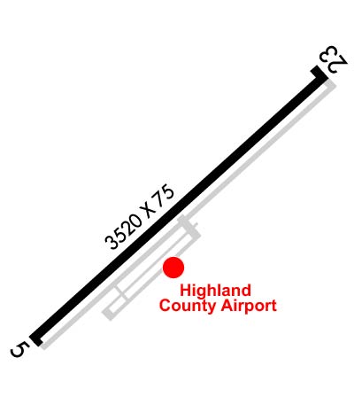
| Lat: N 3911.3 Long: W 08332.3 Elev: 977 Var: +05 Longest Runway: 3520 | ||
| AWOS: 118.17 CTAF: 123.05 | ||
| |||||||||||||||||||||||
| |||||||||||||||||||||||
| |||||||||||||||||||||||
| Rwy | Rwy | |||||||
| 3520x75 | 3520' | 3520x75 | 3520' | |||||
| Runway ID | Single Wheel | Double Wheel | Double Tandem Wheel | Dual Double Wheel |
| 05/23 | 25,000 | N/A | N/A | N/A |
| These numbers are Advisory and are not limits. The Airport Manager should have more accurate Weight Limits | ||||
 Airport Diagram might not be current. | |
| Facility Name: | HIGHLAND COUNTY |
| City Name: | HILLSBORO |
| County: | HIGHLAND |
| State abbrev: | OH |
| State Name: | OHIO |
| Ownership: | PUBLICLY OWNED |
| Use: | OPEN TO THE PUBLIC |
| Owner's Name: | HIGHLAND COUNTY COMMISSIONERS |
| Address: | HIGHLAND COUNTY COURTHOUSE |
| HILLSBORO, OH 45133 | |
| Owner's Phone: | 937-393-9112 |
| Manager's Name: | BOB PROSEK, AIRPORT AUTH PRESIDENT; HOCAIRPORT@CO.HIGHLAND.OH.US. |
| Address: | 9500 N SHORE DR |
| HILLSBORO, OH 45133-7799 | |
| Phone: | 937-393-9112 |
| FAA Region: | GREAT LAKES |
| FAA Field Office: | DET |
| Date | Sunrise | Sunset |
|---|---|---|
| 09/24/21 Friday | 7:23 | 19:28 |
| 09/25/21 Saturday | 7:24 | 19:27 |
| 09/26/21 Sunday | 7:25 | 19:25 |
| 09/27/21 Monday | 7:26 | 19:24 |
| 09/28/21 Tuesday | 7:27 | 19:22 |
| 09/29/21 Wednesday | 7:28 | 19:20 |
| 09/30/21 Thursday | 7:29 | 19:19 |
| 10/01/21 Friday | 7:30 | 19:17 |
| 10/02/21 Saturday | 7:31 | 19:16 |
| 10/03/21 Sunday | 7:32 | 19:14 |
| 10/04/21 Monday | 7:33 | 19:12 |
| 10/05/21 Tuesday | 7:34 | 19:11 |
| 10/06/21 Wednesday | 7:35 | 19:09 |
| 10/07/21 Thursday | 7:36 | 19:08 |
| Airport Attendance Schedule | 7 Days A Week 0800-1700 |
| Airport Status | OPERATIONAL (This Status can change at any time - please check NOTAMS) |
| Airport Lighting Schedule | ACTVT REIL RWY 05 & 23; PAPI RWY 23; MIRL RWY 05/23 - CTAF. |
| Airport Storage Available | Tie Downs, Hanger |
| Extra Services Available | NONE |
| Wind Indicator | YES - (lighted) |
| Control Tower | NO |
| CTAF Frequency | 123.050 |
| Unicom Frequency | 123.050 |
| Rotating Beacon Color | CLEAR-GREEN (Light Land Airport) |
| Segmented Circle | NO |
| Landing Fee | NO |
| Airport Inspected | STATE - performed by PRIVATE CONTRACT PERSONNEL |
| Inspection Date | 09/21/2018 |
| Type of Fuel Available | Grade 100LL |
| Airframe Repair Service | MAJOR |
| Power Plant Repair Service | MAJOR |
| Latitude | N3911.3 |
| Longitude | W08332.3 (ESTIMATED) |
| Arpt Elevation | 977ft (SURVEYED) |
| Magnetic Variation | 05W |
| 3 miles SE | of HILLSBORO |
| Traffic Pattern Altitude | 700 |
| Sectional Chart | CINCINNATI |
| Operations (Reported) | Yearly | Avg. Daily |
|---|---|---|
| General Aviation Transient | 3860 | 11 |
| General Aviation Local | 3860 | 11 |
| Air Taxi | 30 | 0 |
| Commerical | 0 | 0 |
| Commuter | 0 | 0 |
| Military | 250 | 1 |
| Aircraft based on Field | |
|---|---|
| General Aviation Singles | 17 |
| General Aviation Multi | 0 |
| Jet Aircraft | 0 |
| General Aviation Helicopters | 0 |
| Military Aircraft | 0 |
| Gliders | 0 |
| Ultralights | 0 |
| FSS on field | NO |
| FSS tie-in | DAYTON |
| FSS Phone | 1-800-WX-BRIEF |
| Who issues Notams | DAY |
| Notam D service at airport | YES |
| ARTCC Name | INDIANAPOLIS |
| Airport Certification | |
| Aircraft Rescue & Firefighting Index | None |
| Airport of Entry | No |
| Custom Landing Rights | No |
| Joint Civil/Military | No |
| Military Landing rights | No |
| NATIONAL PLAN OF INTEGRATED AIRPORT SYSTEMS (NPIAS) |
| THIS AIRPORT HAS BEEN SURVEYED BY THE NATIONAL GEODETIC SURVEY. |
| DEER & BIRDS ON & INVOF ARPT. |
| FOR CD IF UNA TO CTC ON FSS FREQ, CTC INDIANAPOLIS ARTCC AT 317-247-2411. |
Airport Communications & Frequencies:
| |||||||||
| Runway: 05 | Runway: 23 | ||
| Mag heading: | 54° | Mag heading: | 234° |
| Rwy Slope: | -1.32% Down | Rwy Slope: | 1.32% Up |
| Approach: | Approach: | ||
| Pattern: | Left Traffic | Pattern: | Left Traffic |
| Markings: | NONPRECISION INSTRUMENT | Markings: | NONPRECISION INSTRUMENT |
| Marking Condition: | GOOD | Marking Condition: | GOOD |
| Arresting Dev: | Arresting Dev: | ||
| Lat & Long: | N3911.1 W08332.6 | Lat. & Long.: | N3911.5 W08332.0 |
| Elev: | 977.3 ft. MSL | Elev: | 930.9 ft. MSL |
| TCH: | TCH: | 32 ft. AGL | |
| Visual Glide Path: | Visual Glide Path: | 4.00 degrees | |
| Displaced Threshold: | No | Displaced Threshold: | No |
| Touchdown Zone: | YES | Touchdown Zone: | YES |
| Touchdown Elev.: | 977.3 feet | Touchdown Elev.: | 969.2 feet |
| Visual Glide Slope: | Visual Glide Slope: | 2-Light PAPI on LEFT side of Runway | |
| RVR Equipment: | RVR Equipment: | ||
| RVV Equipment: | NO | RVV Equipment: | NO |
| Approach Lights: | Approach Lights: | ||
| REIL: | YES | REIL: | YES |
| Centerline Lights: | NO | Centerline Lights: | NO |
| Touchdown lights: | NO | Touchdown lights: | NO |
| Runway Category: | Runway with a Visual Approach | Runway Category: | Runway with a Non-precision Approach |
| Declared Distances: | Declared Distances: | ||
| Obstructions: | TREE | Obstructions: | TREES |
| Marked: | NOT Marked/Lighted | Marked: | NOT Marked/Lighted |
| Clearance slope: | 6:1 | Clearance slope: | |
| Obstruction height: | 15 feet AGL | Obstruction height: | 30 feet AGL |
| Dist. from runway: | 295 feet | Dist. from runway: | 201 feet |
| Centerline offset: | 200 left of centerline | Centerline offset: | 250 feet left of centerline |
| Comments: | +10 FT CROPS, 0-180 FT DIST, 135 FT L. | Comments: | +12 FT TREE, 80 FT DIST, 164 FT R. |
Thanks for using FltPlan.com
all rights reserved © 1999-2021 by Flight Plan LLC