
| PARK TOWNSHIP HOLLAND MI |
| |
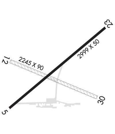
| Lat: N 4247.8 Long: W 08609.7 Elev: 603 Var: +03 Longest Runway: 2999 | ||
| Clr Del: 123.95 CTAF: 122.8 | ||
| ||||||
|
| Rwy | Rwy | |||||||
| 2999x50 | 2274' | 2999x50 | 1857' | |||||
| 2245x90 | 1226' | 2245x90 | 1425' | |||||
| Runway ID | Single Wheel | Double Wheel | Double Tandem Wheel | Dual Double Wheel |
| These numbers are Advisory and are not limits. The Airport Manager should have more accurate Weight Limits | ||||
| FltPlan does not have IFR approach charts available for KHLM. |
 Airport Diagram might not be current. | |
| Facility Name: | PARK TOWNSHIP |
| City Name: | HOLLAND |
| County: | OTTAWA |
| State abbrev: | MI |
| State Name: | MICHIGAN |
| Ownership: | PUBLICLY OWNED |
| Use: | OPEN TO THE PUBLIC |
| Owner's Name: | PARK TOWNSHIP |
| Address: | PARK TOWNSHIP HALL, 52 152ND AVE |
| HOLLAND, MI 49424 | |
| Owner's Phone: | 616-399-4520 |
| Manager's Name: | JAMES MUNSLOW |
| Address: | 1269 OTTAWA BEACH ROAD |
| HOLLAND, MI 49424 | |
| Phone: | (616) 399-9333; AFTR HRS 616-894-9956 (MGR RES). |
| FAA Region: | GREAT LAKES |
| FAA Field Office: | DET |
| Date | Sunrise | Sunset |
|---|---|---|
| 10/17/20 Saturday | 8:01 | 18:58 |
| 10/18/20 Sunday | 8:02 | 18:56 |
| 10/19/20 Monday | 8:04 | 18:55 |
| 10/20/20 Tuesday | 8:05 | 18:53 |
| 10/21/20 Wednesday | 8:06 | 18:52 |
| 10/22/20 Thursday | 8:07 | 18:50 |
| 10/23/20 Friday | 8:09 | 18:49 |
| 10/24/20 Saturday | 8:10 | 18:47 |
| 10/25/20 Sunday | 8:11 | 18:46 |
| 10/26/20 Monday | 8:12 | 18:44 |
| 10/27/20 Tuesday | 8:14 | 18:43 |
| 10/28/20 Wednesday | 8:15 | 18:41 |
| 10/29/20 Thursday | 8:16 | 18:40 |
| 10/30/20 Friday | 8:17 | 18:39 |
| Airport Attendance Schedule | UNATTENDED |
| Airport Status | OPERATIONAL (This Status can change at any time - please check NOTAMS) |
| Airport Lighting Schedule | ACTVT NSTD MIRL RWY 05/23 SS-2300. AFT 2300, CTAF. |
| Airport Storage Available | Tie Downs, Hanger |
| Extra Services Available | Parachute Jumping |
| Wind Indicator | YES - (lighted) |
| Control Tower | NO |
| CTAF Frequency | 122.800 |
| Unicom Frequency | 122.800 |
| Rotating Beacon Color | CLEAR-GREEN (Light Land Airport) |
| Segmented Circle | YES |
| Landing Fee |
| Airport Inspected | STATE - performed by STATE AERONAUTICAL PERSONNEL |
| Inspection Date | 09/10/2015 |
| Type of Fuel Available | Grade 100LLMOGAS |
| Airframe Repair Service | None |
| Power Plant Repair Service | None |
| Latitude | N4247.8 |
| Longitude | W08609.7 (ESTIMATED) |
| Arpt Elevation | 603ft (SURVEYED) |
| Magnetic Variation | 03W |
| 3 miles NW | of HOLLAND |
| Traffic Pattern Altitude | |
| Sectional Chart | CHICAGO |
| Operations (Reported) | Yearly | Avg. Daily |
|---|---|---|
| General Aviation Transient | 2250 | 6 |
| General Aviation Local | 2250 | 6 |
| Air Taxi | 0 | 0 |
| Commerical | 0 | 0 |
| Commuter | 0 | 0 |
| Military | 0 | 0 |
| Aircraft based on Field | |
|---|---|
| General Aviation Singles | 16 |
| General Aviation Multi | 0 |
| Jet Aircraft | 0 |
| General Aviation Helicopters | 0 |
| Military Aircraft | 0 |
| Gliders | 0 |
| Ultralights | 2 |
| FSS on field | NO |
| FSS tie-in | LANSING |
| FSS Phone | 1-800-WX-BRIEF |
| Who issues Notams | LAN |
| Notam D service at airport | YES |
| ARTCC Name | CHICAGO |
| Airport Certification | |
| Aircraft Rescue & Firefighting Index | None |
| Airport of Entry | No |
| Custom Landing Rights | No |
| Joint Civil/Military | No |
| Military Landing rights | No |
| THIS AIRPORT HAS BEEN SURVEYED BY THE NATIONAL GEODETIC SURVEY. |
| TREES IN TRANSITIONAL SURFACES BOTH SIDES OF RYS 05/23 & 12/30. |
| DEP PROCEDURE: RY 5 AND 23, CLIMB STRAIGHT-OUT TO 1200 FT MSL BEFORE TURNING. |
| RY 12/30 CLSD NOV THRU MAR & WHEN SNOW COVERED. |
| ANIMALS, DEER & BIRDS ON & INVOF ARPT. |
| SKYDIVING ACTVTY DAILY 1000-SS. |
| FOR CD WHEN GREAT LAKES APCH CLSD CTC CHICAGO ARTCC AT 630-906-8921. |
| RWY 05/2 3 NUMEROUS CRACKS IN PVMNT. |
| RWY 05/2 3 NSTD; LGTS LCTD 24 FT FM RY EDGE. END LIGHTS OUTBOARD OF PAVEMENT, ONLY 2 ON EACH SIDE. |
| Runway: 05 | Runway: 23 | ||
| Mag heading: | 53° | Mag heading: | 233° |
| Rwy Slope: | -.03% Down | Rwy Slope: | .03% Up |
| Approach: | Approach: | ||
| Pattern: | Left Traffic | Pattern: | Left Traffic |
| Markings: | BASIC | Markings: | BASIC |
| Marking Condition: | POOR; RY 05 NSTD MKGS-RY NUMBERS NOT LOCATED CORRECTLY. MARKINGS FADED. | Marking Condition: | POOR; RY 23 NSTD MKGS-RY NUMBERS NOT LOCATED CORRECTLY. MARKINGS FADED. |
| Arresting Dev: | Arresting Dev: | ||
| Lat & Long: | N4247.6 W08610.0 | Lat. & Long.: | N4247.9 W08609.5 |
| Elev: | 603.0 ft. MSL | Elev: | 602.0 ft. MSL |
| TCH: | TCH: | ||
| Visual Glide Path: | Visual Glide Path: | ||
| Displaced Threshold: | 725 feet | Displaced Threshold: | 1142 feet |
| Touchdown Zone: | YES | Touchdown Zone: | YES |
| Touchdown Elev.: | 603.0 feet | Touchdown Elev.: | 603.0 feet |
| Visual Glide Slope: | Visual Glide Slope: | ||
| RVR Equipment: | RVR Equipment: | ||
| RVV Equipment: | NO | RVV Equipment: | NO |
| Approach Lights: | Approach Lights: | ||
| REIL: | NO | REIL: | NO |
| Centerline Lights: | NO | Centerline Lights: | NO |
| Touchdown lights: | NO | Touchdown lights: | NO |
| Runway Category: | Runway with a Visual Approach | Runway Category: | Runway with a Visual Approach |
| Declared Distances: | Declared Distances: | ||
| Obstructions: | ROAD; ALSO 50 FT TREES, 0 FT DSTC, 125 FT L. | Obstructions: | TREES |
| Marked: | NOT Marked/Lighted | Marked: | NOT Marked/Lighted |
| Clearance slope: | APCH RATIO 9:1 AT DSPLCD THLD OVER 56 FT TREE, 523 FT DSTC, 175 L; 20:1 BASED ON STRAIGHT OUT OVER 56 FT TREE, 400 FT DSTC, 0 FT BOTH. | Clearance slope: | APCH RATIO 3:1 AT DSPLCD THLD, 20 FT TREE, 60 FT DSTC, 130 FT R. |
| Obstruction height: | 15 feet AGL | Obstruction height: | 67 feet AGL |
| Dist. from runway: | 201 feet | Dist. from runway: | 201 feet |
| Centerline offset: | 25 left of centerline | Centerline offset: | |
| Comments: | ROAD/FENCE/BIKE PATH & TREES ALL QUADS. | Comments: | ROAD/FENCE/BIKE PATH /HOUSES & TREES ALL QUADS. |
| Runway: 12 | Runway: 30 | ||
| Mag heading: | 116° | Mag heading: | 296° |
| Approach: | Approach: | ||
| Pattern: | Left Traffic | Pattern: | Left Traffic |
| Markings: | Markings: | ||
| Marking Condition: | RY 12/30 & DSPLCD THLDS MKD WITH 3 FT YELLOW CONES. | Marking Condition: | |
| Arresting Dev: | Arresting Dev: | ||
| Lat & Long: | N4247.8 W08610.0 | Lat. & Long.: | N4247.6 W08609.5 |
| Elev: | N/A | Elev: | N/A |
| TCH: | TCH: | ||
| Visual Glide Path: | Visual Glide Path: | ||
| Displaced Threshold: | 1019 feet | Displaced Threshold: | 820 feet |
| Touchdown Zone: | NO | Touchdown Zone: | NO |
| Touchdown Elev.: | Touchdown Elev.: | ||
| Visual Glide Slope: | Visual Glide Slope: | ||
| RVR Equipment: | RVR Equipment: | ||
| RVV Equipment: | NO | RVV Equipment: | NO |
| Approach Lights: | Approach Lights: | ||
| REIL: | NO | REIL: | NO |
| Centerline Lights: | NO | Centerline Lights: | NO |
| Touchdown lights: | NO | Touchdown lights: | NO |
| Runway Category: | Runway with a Visual Approach | Runway Category: | Runway with a Visual Approach |
| Declared Distances: | Declared Distances: | ||
| Obstructions: | TREES | Obstructions: | TREES |
| Marked: | NOT Marked/Lighted | Marked: | NOT Marked/Lighted |
| Clearance slope: | APCH RATIO 14:1 AT DSPLCD THLD OVER 73 FT TREES, 1054 FT DSTC, 70 FT R; 20:1 BASED ON STRAIGHT OUT OVER 71 FT TREES, 1450 FT DSTC, 0 FT BOTH. | Clearance slope: | 5:1; APCH RATIO 15:1 AT DSPLCD THLD, 83 FT TREES, 1,300 FT DSTC, 96 FT R; 20:1 BASED ON STRAIGHT OUT OVR 64 FT TREES, 1288 FT DSTC, 65 FT R. |
| Obstruction height: | 63 feet AGL | Obstruction height: | 57 feet AGL |
| Dist. from runway: | 0 feet | Dist. from runway: | 285 feet |
| Centerline offset: | 50B | Centerline offset: | 81 feet right of centerline |
| Comments: | Comments: |
Thanks for using FltPlan.com
all rights reserved © 1999-2020 by Flight Plan LLC
