
| WINTER HAVEN'S GILBERT WINTER HAVEN FL |
| |
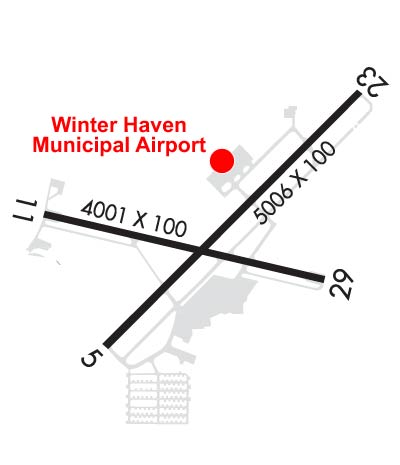
| Lat: N 2803.8 Long: W 08145.2 Elev: 145 Var: +04 Longest Runway: 5006 | ||
| Clr Del: 121.72 GCO AWOS: 133.67 CTAF: 123.05 | ||
| |||||||||||||||||||||||||||||||||||||||||||||||||||||||||||||||||||||
| |||||||||||||||||||||||||||||||||||||||||||||||||||||||||||||||||||||
| |||||||||||||||||||||||||||||||||||||||||||||||||||||||||||||||||||||
| |||||||||||||||||||||||||||||||||||||||||||||||||||||||||||||||||||||
| Rwy | Rwy | |||||||
| 5006x100 | 5006' | 5006x100 | 5006' | |||||
| 4001x60 | 4001' | 4001x60 | 4001' | |||||
| Runway ID | Single Wheel | Double Wheel | Double Tandem Wheel | Dual Double Wheel |
| 05/23 | 89,000 | 142,000 | N/A | N/A |
| 11/29 | 94,000 | 151,000 | N/A | N/A |
| These numbers are Advisory and are not limits. The Airport Manager should have more accurate Weight Limits | ||||
 Airport Diagram might not be current. | |
| Facility Name: | WINTER HAVEN RGNL |
| City Name: | WINTER HAVEN |
| County: | POLK |
| State abbrev: | FL |
| State Name: | FLORIDA |
| Ownership: | PUBLICLY OWNED |
| Use: | OPEN TO THE PUBLIC |
| Owner's Name: | CITY OF WINTER HAVEN; CONTACT PERSON: MIKE HERR |
| Address: | P.O. BOX 2277 |
| WINTER HAVEN, FL 33883-2277 | |
| Owner's Phone: | 863-291-5600 |
| Manager's Name: | ALEXANDER VACHA |
| Address: | 2073 HWY 92 WEST |
| WINTER HAVEN, FL 33881 | |
| Phone: | 863-298-4551 |
| FAA Region: | SOUTHERN |
| FAA Field Office: | ORL |

| Date | Sunrise | Sunset |
|---|---|---|
| 09/24/21 Friday | 7:16 | 19:21 |
| 09/25/21 Saturday | 7:17 | 19:20 |
| 09/26/21 Sunday | 7:17 | 19:19 |
| 09/27/21 Monday | 7:18 | 19:18 |
| 09/28/21 Tuesday | 7:18 | 19:17 |
| 09/29/21 Wednesday | 7:19 | 19:16 |
| 09/30/21 Thursday | 7:19 | 19:14 |
| 10/01/21 Friday | 7:20 | 19:13 |
| 10/02/21 Saturday | 7:20 | 19:12 |
| 10/03/21 Sunday | 7:21 | 19:11 |
| 10/04/21 Monday | 7:21 | 19:10 |
| 10/05/21 Tuesday | 7:22 | 19:09 |
| 10/06/21 Wednesday | 7:22 | 19:08 |
| 10/07/21 Thursday | 7:23 | 19:06 |
| Airport Attendance Schedule | 7 Days A Week 0700-1900 |
| Airport Status | OPERATIONAL (This Status can change at any time - please check NOTAMS) |
| Airport Lighting Schedule | ACTVT REIL RWY 11 & 29; PAPI RWY 05 & 23; MIRL RWY 05/23 & 11/29 - CTAF. |
| Airport Storage Available | Tie Downs, Hanger |
| Extra Services Available | Avionics, Flight Instruction, Aircraft Rental, Aircraft Sales |
| Wind Indicator | YES - (lighted) |
| Control Tower | NO |
| CTAF Frequency | 123.050 |
| Unicom Frequency | 123.050 |
| Rotating Beacon Color | CLEAR-GREEN (Light Land Airport) |
| Segmented Circle | NO |
| Landing Fee | NO |
| Airport Inspected | STATE - performed by STATE AERONAUTICAL PERSONNEL |
| Inspection Date | 07/24/2018 |
| Type of Fuel Available | Grade 100LL, JET A (freeze point -40C)MOGAS |
| Airframe Repair Service | MAJOR |
| Power Plant Repair Service | MAJOR |
| Latitude | N2803.8 |
| Longitude | W08145.2 (ESTIMATED) |
| Arpt Elevation | 145ft (SURVEYED) |
| Magnetic Variation | 04W |
| 3 miles NW | of WINTER HAVEN |
| Traffic Pattern Altitude | 855 |
| Sectional Chart | JACKSONVILLE |
| Operations (Reported) | Yearly | Avg. Daily |
|---|---|---|
| General Aviation Transient | 31200 | 85 |
| General Aviation Local | 46798 | 128 |
| Air Taxi | 0 | 0 |
| Commerical | 0 | 0 |
| Commuter | 0 | 0 |
| Military | 0 | 0 |
| Aircraft based on Field | |
|---|---|
| General Aviation Singles | 138 |
| General Aviation Multi | 10 |
| Jet Aircraft | 0 |
| General Aviation Helicopters | 2 |
| Military Aircraft | 0 |
| Gliders | 1 |
| Ultralights | 0 |
| FSS on field | NO |
| FSS tie-in | SAINT PETERSBURG |
| FSS Phone | 1-800-WX-BRIEF |
| Who issues Notams | GIF |
| Notam D service at airport | YES |
| ARTCC Name | MIAMI |
| Airport Certification | |
| Aircraft Rescue & Firefighting Index | None |
| Airport of Entry | No |
| Custom Landing Rights | No |
| Joint Civil/Military | No |
| Military Landing rights | YES |
| NATIONAL PLAN OF INTEGRATED AIRPORT SYSTEMS (NPIAS) |
| GRANT AGREEMENTS UNDER FAAP/ADAP/AIP |
| ASSURANCES PURSUANT TO TITLE VI, CIVIL RIGHTS ACT OF 1964 |
| AGREEMENT UNDER DLAND OR DCLA HAS EXPIRED. |
| THIS AIRPORT HAS BEEN SURVEYED BY THE NATIONAL GEODETIC SURVEY. |
| BROWN'S SPB LOCATED ON ADJACENT LAKE. |
| ANEMOMETER REMOTED TO FBO OFFICE. |
| GLIDER ACFT OPERG ON AND INVOF ARPT. |
| GCO AVBL ON FREQ 121.725 THRU TAMPA CD. |
| RWY 05 PREFERRED FOR CALM OR LIGHT WINDS |
| FOR CD IF UNA VIA GCO CTC TAMPA APCH AT 813-878-2528 OR 813-371-7745. |
Airport Communications & Frequencies:
| ||||||||||||||||||
| Runway: 05 | Runway: 23 | ||
| Mag heading: | 49° | Mag heading: | 229° |
| Rwy Slope: | -.01% Down | Rwy Slope: | .01% Up |
| Approach: | Approach: | ||
| Pattern: | Left Traffic | Pattern: | Left Traffic |
| Markings: | NONPRECISION INSTRUMENT | Markings: | NONPRECISION INSTRUMENT |
| Marking Condition: | GOOD | Marking Condition: | GOOD |
| Arresting Dev: | Arresting Dev: | ||
| Lat & Long: | N2803.5 W08145.5 | Lat. & Long.: | N2804.1 W08144.8 |
| Elev: | 141.7 ft. MSL | Elev: | 141.2 ft. MSL |
| TCH: | 50 ft. AGL | TCH: | 50 ft. AGL |
| Visual Glide Path: | 3.00 degrees | Visual Glide Path: | 3.00 degrees |
| Displaced Threshold: | No | Displaced Threshold: | No |
| Touchdown Zone: | YES | Touchdown Zone: | YES |
| Touchdown Elev.: | 145.3 feet | Touchdown Elev.: | 144.8 feet |
| Visual Glide Slope: | 2-Light PAPI on LEFT side of Runway | Visual Glide Slope: | 2-Light PAPI on LEFT side of Runway |
| RVR Equipment: | RVR Equipment: | ||
| RVV Equipment: | NO | RVV Equipment: | NO |
| Approach Lights: | Approach Lights: | ||
| REIL: | YES | REIL: | YES |
| Centerline Lights: | NO | Centerline Lights: | NO |
| Touchdown lights: | NO | Touchdown lights: | NO |
| Runway Category: | Runway with a Non-precision Approach having visibility minimums greater than 3/4 mile | Runway Category: | Runway with a Visual Approach |
| Declared Distances: | Declared Distances: | ||
| Obstructions: | FENCE | Obstructions: | BRUSH |
| Marked: | NOT Marked/Lighted | Marked: | NOT Marked/Lighted |
| Clearance slope: | 1:1; RWY 05 APCH SLOPE 1:1 DUE TO 5 FT FENCE 205 FT FM THE RWY END AND 250 FT LEFT. | Clearance slope: | 1:1; RWY 23 APCH SLOPE 1:1 DUE TO 5 FT BRUSH 70 FT FM THE RWY END AND 250 FT LEFT. |
| Obstruction height: | 5 feet AGL | Obstruction height: | 5 feet AGL |
| Dist. from runway: | 5 feet | Dist. from runway: | 0 feet |
| Centerline offset: | 250 left of centerline | Centerline offset: | 195 feet left of centerline |
| Comments: | Comments: |
| Runway: 11 | Runway: 29 | ||
| Mag heading: | 107° | Mag heading: | 287° |
| Rwy Slope: | -.05% Down | Rwy Slope: | .05% Up |
| Approach: | Approach: | ||
| Pattern: | Left Traffic | Pattern: | Left Traffic |
| Markings: | NONPRECISION INSTRUMENT | Markings: | BASIC |
| Marking Condition: | GOOD | Marking Condition: | GOOD |
| Arresting Dev: | Arresting Dev: | ||
| Lat & Long: | N2803.8 W08145.6 | Lat. & Long.: | N2803.7 W08144.9 |
| Elev: | 143.0 ft. MSL | Elev: | 141.0 ft. MSL |
| TCH: | TCH: | ||
| Visual Glide Path: | Visual Glide Path: | ||
| Displaced Threshold: | No | Displaced Threshold: | No |
| Touchdown Zone: | YES | Touchdown Zone: | YES |
| Touchdown Elev.: | 145.3 feet | Touchdown Elev.: | 145.3 feet |
| Visual Glide Slope: | Visual Glide Slope: | ||
| RVR Equipment: | RVR Equipment: | ||
| RVV Equipment: | NO | RVV Equipment: | NO |
| Approach Lights: | Approach Lights: | ||
| REIL: | YES | REIL: | YES |
| Centerline Lights: | NO | Centerline Lights: | NO |
| Touchdown lights: | NO | Touchdown lights: | NO |
| Runway Category: | Runway with a Non-precision Approach | Runway Category: | Runway with a Visual Approach |
| Declared Distances: | Declared Distances: | ||
| Obstructions: | PLINE | Obstructions: | FENCE |
| Marked: | NOT Marked/Lighted | Marked: | LIGHTED |
| Clearance slope: | 28:1 | Clearance slope: | 8:1 |
| Obstruction height: | 43 feet AGL | Obstruction height: | 5 feet AGL |
| Dist. from runway: | 1430 feet | Dist. from runway: | 240 feet |
| Centerline offset: | 60 left of centerline | Centerline offset: | 250 feet left of centerline |
| Comments: | Comments: |
Thanks for using FltPlan.com
all rights reserved © 1999-2021 by Flight Plan LLC


