
| SPOKANE INTL SPOKANE WA |
| |
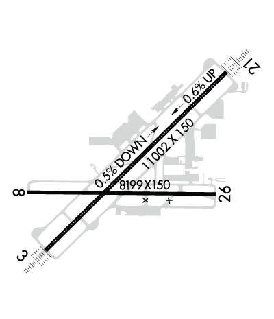
| Lat: N 4737.1 Long: W 11732.1 Elev: 2385 Var: -14 Longest Runway: 11002 | ||
| Clr Del: 127.55 Dept. ATIS: 124.32 Arr. ATIS: 124.32 Ground: 121.9 Tower: 118.3 | ||
| ||||||||||||||||||||||||||||||||||||||||||||||||||||||||||||||||||||
| ||||||||||||||||||||||||||||||||||||||||||||||||||||||||||||||||||||
| ||||||||||||||||||||||||||||||||||||||||||||||||||||||||||||||||||||
| ||||||||||||||||||||||||||||||||||||||||||||||||||||||||||||||||||||
| Rwy | Rwy | |||||||
| 11002x150 | 11002' | 111.10 - 031° | 11002x150 | 11002' | 111.10 - 211° | |||
| 8199x150 | 8199' | 8199x150 | 8199' | |||||
| Runway ID | Single Wheel | Double Wheel | Double Tandem Wheel | Dual Double Wheel |
| 03/21 | 200,000 | 200,000 | 400,000 | N/A |
| 08/26 | 150,000 | 180,000 | 280,000 | N/A |
| These numbers are Advisory and are not limits. The Airport Manager should have more accurate Weight Limits | ||||
 Airport Diagram might not be current. | |
| Facility Name: | SPOKANE INTL |
| City Name: | SPOKANE |
| County: | SPOKANE |
| State abbrev: | WA |
| State Name: | WASHINGTON |
| Ownership: | PUBLICLY OWNED |
| Use: | OPEN TO THE PUBLIC |
| Owner's Name: | SPOKANE COUNTY-CITY |
| Address: | ARPT BOARD, 9000 W AIRPORT DRIVE |
| SPOKANE, WA 99224 | |
| Owner's Phone: | 509-455-6455 |
| Manager's Name: | FRANK MILLER |
| Address: | 9000 W AIRPORT DR., SUITE 204 |
| SPOKANE, WA 99224 | |
| Phone: | 509-455-6455 |
| FAA Region: | NORTHWEST MOUNTAIN |
| FAA Field Office: | SEA |
| Date | Sunrise | Sunset |
|---|---|---|
| 02/16/26 Monday | 6:54 | 17:15 |
| 02/17/26 Tuesday | 6:53 | 17:16 |
| 02/18/26 Wednesday | 6:51 | 17:18 |
| 02/19/26 Thursday | 6:49 | 17:20 |
| 02/20/26 Friday | 6:48 | 17:21 |
| 02/21/26 Saturday | 6:46 | 17:23 |
| 02/22/26 Sunday | 6:44 | 17:24 |
| 02/23/26 Monday | 6:42 | 17:26 |
| 02/24/26 Tuesday | 6:40 | 17:27 |
| 02/25/26 Wednesday | 6:39 | 17:29 |
| 02/26/26 Thursday | 6:37 | 17:30 |
| 02/27/26 Friday | 6:35 | 17:32 |
| 02/28/26 Saturday | 6:33 | 17:33 |
| 03/01/26 Sunday | 6:31 | 17:35 |
| Airport Attendance Schedule | CONTINUOUS |
| Airport Status | OPERATIONAL (This Status can change at any time - please check NOTAMS) |
| Airport Lighting Schedule | |
| Airport Storage Available | Tie Downs, Hanger |
| Extra Services Available | Air Freight, Avionics, Cargo Handling, Flight Instruction, Aircraft Rental, Aircraft Sales |
| Wind Indicator | YES - (lighted) |
| Control Tower | YES |
| CTAF Frequency | |
| Unicom Frequency | 122.950 |
| Rotating Beacon Color | WG |
| Segmented Circle | NO |
| Landing Fee | NO |
| Airport Inspected | FEDERAL - performed by FAA AIRPORTS FIELD PERSONNEL |
| Inspection Date | 03/22/2024 |
| Type of Fuel Available | Grade 100, Grade 100LL, JET A (freeze point -40C) |
| Airframe Repair Service | MAJOR |
| Power Plant Repair Service | MAJOR |
| Latitude | N4737.1 |
| Longitude | W11732.1 (ESTIMATED) |
| Arpt Elevation | 2385ft (SURVEYED) |
| Magnetic Variation | 14E |
| 5 miles SW | of SPOKANE |
| Traffic Pattern Altitude | |
| Sectional Chart | SEATTLE |
| Operations (Reported) | Yearly | Avg. Daily |
|---|---|---|
| General Aviation Transient | 0 | 0 |
| General Aviation Local | 0 | 0 |
| Air Taxi | 0 | 0 |
| Commerical | 0 | 0 |
| Commuter | 0 | 0 |
| Military | 0 | 0 |
| Aircraft based on Field | |
|---|---|
| General Aviation Singles | 0 |
| General Aviation Multi | 0 |
| Jet Aircraft | 0 |
| General Aviation Helicopters | 0 |
| Military Aircraft | 0 |
| Gliders | 0 |
| Ultralights | 0 |
| FSS on field | NO |
| FSS tie-in | SEATTLE |
| FSS Phone | 1-800-WX-BRIEF |
| Who issues Notams | GEG |
| Notam D service at airport | YES |
| ARTCC Name | SEATTLE |
| Airport Certification | AIRPORT RECEIVING SCHEDULED AIR CARRIER SERVICE FROM CARRIERS CERTIFICATED BY THE CIVIL AERONAUTICS BOARD |
| Aircraft Rescue & Firefighting Index | AIRPORT HAS A CERTIFICATE UNDER CFR PART 139 |
| Airport of Entry | No |
| Custom Landing Rights | YES |
| Joint Civil/Military | No |
| Military Landing rights | YES |
| NATIONAL PLAN OF INTEGRATED AIRPORT SYSTEMS (NPIAS) |
| GRANT AGREEMENTS UNDER FAAP/ADAP/AIP |
| SURPLUS PROPERTY AGREEMENT UNDER PUBLIC LAW 289 |
| ASSURANCES PURSUANT TO TITLE VI, CIVIL RIGHTS ACT OF 1964 |
| BE ALERT TO TURBULENCE OVER SMOKE STACKS 1 MILE EAST OF ARPT. |
| WATERFOWL & BIRDS ON & INVOF ARPT. |
| TWY K UNLGTD ON RAMP SIDE ALONG MAINTENANCE RAMP AND IS UNAVBL BELOW 1200 RVR UNLESS UNDER ESCORT BY "FOLLOW ME". |
| PORTIONS OF TWY K NOT VISIBLE FM ATCT. |
| RWY 03/2 1 PCR VALUE: 660/R/A/W/T |
| RWY 08/2 6 PCR VALUE: 730/R/A/W/T |
Airport Communications & Frequencies:
| ||||||||||||||||||||||||||||||||||||||||||||||||||
| Runway: 03 | Runway: 21 | ||
| Mag heading: | 31° | Mag heading: | 211° |
| Rwy Slope: | -.57% Down | Rwy Slope: | .57% Up |
| Approach: | ILS/DME | Approach: | ILS/DME |
| Pattern: | Right Traffic | Pattern: | Left Traffic |
| Markings: | PRECISION INSTRUMENT | Markings: | PRECISION INSTRUMENT |
| Marking Condition: | GOOD | Marking Condition: | GOOD |
| Arresting Dev: | Arresting Dev: | ||
| Lat & Long: | N4736.6 W11733.0 | Lat. & Long.: | N4737.9 W11731.1 |
| Elev: | 2385.0 ft. MSL | Elev: | 2322.4 ft. MSL |
| TCH: | 69 ft. AGL | TCH: | 73 ft. AGL |
| Visual Glide Path: | 3.00 degrees | Visual Glide Path: | 3.00 degrees |
| Displaced Threshold: | No | Displaced Threshold: | No |
| Touchdown Zone: | YES | Touchdown Zone: | YES |
| Touchdown Elev.: | 2385.0 feet | Touchdown Elev.: | 2346.1 feet |
| Visual Glide Slope: | 4-Light PAPI on LEFT side of Runway | Visual Glide Slope: | 4-Light PAPI on LEFT side of Runway |
| RVR Equipment: | TOUCHDOWN-MIDFIELD-ROLLOUT | RVR Equipment: | TOUCHDOWN-MIDFIELD-ROLLOUT |
| RVV Equipment: | NO | RVV Equipment: | NO |
| Approach Lights: | ALSF2 - standard 2,400 foot high intensity approach lighting system with sequenced flashers, Category II or III | Approach Lights: | ALSF2 - standard 2,400 foot high intensity approach lighting system with sequenced flashers, Category II or III; ALSF 2 MAY BE OPERATED AS SSALR DURING FAVORABLE WX CONDITIONS. |
| REIL: | NO | REIL: | NO |
| Centerline Lights: | YES | Centerline Lights: | YES |
| Touchdown lights: | YES | Touchdown lights: | YES |
| Runway Category: | Precision Instrument Runway | Runway Category: | Precision Instrument Runway |
| Declared Distances: | TORA:11002' TODA:11002' ASDA:11002' LDA:11002' | Declared Distances: | TORA:11002' TODA:11002' ASDA:11002' LDA:11002' |
| Obstructions: | Obstructions: | GND | |
| Marked: | Marked: | NOT Marked/Lighted | |
| Clearance slope: | 50:1 | Clearance slope: | 13:1 |
| Obstruction height: | Obstruction height: | 9 feet AGL | |
| Dist. from runway: | Dist. from runway: | 325 feet | |
| Centerline offset: | Centerline offset: | 500 feet left of centerline | |
| Comments: | Comments: |
| Runway: 08 | Runway: 26 | ||
| Mag heading: | 76° | Mag heading: | 256° |
| Rwy Slope: | -.06% Down | Rwy Slope: | .06% Up |
| Approach: | Approach: | ||
| Pattern: | Right Traffic | Pattern: | Left Traffic |
| Markings: | NONPRECISION INSTRUMENT | Markings: | NONPRECISION INSTRUMENT |
| Marking Condition: | GOOD | Marking Condition: | GOOD |
| Arresting Dev: | Arresting Dev: | ||
| Lat & Long: | N4737.0 W11733.2 | Lat. & Long.: | N4737.0 W11731.2 |
| Elev: | 2376.2 ft. MSL | Elev: | 2371.5 ft. MSL |
| TCH: | 45 ft. AGL | TCH: | 48 ft. AGL |
| Visual Glide Path: | 3.00 degrees | Visual Glide Path: | 3.00 degrees |
| Displaced Threshold: | No | Displaced Threshold: | No |
| Touchdown Zone: | YES | Touchdown Zone: | YES |
| Touchdown Elev.: | 2376.2 feet | Touchdown Elev.: | 2371.5 feet |
| Visual Glide Slope: | 4-Light PAPI on RIGHT side of Runway | Visual Glide Slope: | 4-Light PAPI on LEFT side of Runway |
| RVR Equipment: | RVR Equipment: | ||
| RVV Equipment: | NO | RVV Equipment: | NO |
| Approach Lights: | Approach Lights: | ||
| REIL: | YES | REIL: | YES |
| Centerline Lights: | NO | Centerline Lights: | NO |
| Touchdown lights: | NO | Touchdown lights: | NO |
| Runway Category: | Runway with a Non-precision Approach having visibility minimums greater than 3/4 mile | Runway Category: | Runway with a Non-precision Approach having visibility minimums greater than 3/4 mile |
| Declared Distances: | TORA:8199' TODA:8199' ASDA:8199' LDA:8199' | Declared Distances: | TORA:8199' TODA:8199' ASDA:8199' LDA:8199' |
Thanks for using FltPlan.com
all rights reserved © 1999-2026 by Flight Plan LLC


