| FORT WORTH SPINKS FORT WORTH TX |
| |
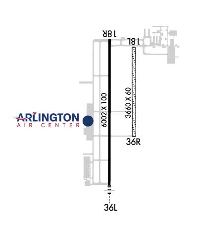
| Lat: N 3233.9 Long: W 09718.5 Elev: 700 Var: -07 Longest Runway: 6002 | ||
| Dept. ATIS: 120.02 Arr. ATIS: 120.02 AWOS: 120.02 Ground: 119.47 Tower: 124.62 | ||
| |||||||||||||||||||||||||||||||
| |||||||||||||||||||||||||||||||
| |||||||||||||||||||||||||||||||
| Rwy | Rwy | |||||||
| 3660x60 | 3660' | 3660x60 | 3660' | |||||
| 6002x100 | 6002' | 6002x100 | 6002' | 110.95 - 353° | ||||
| Runway ID | Single Wheel | Double Wheel | Double Tandem Wheel | Dual Double Wheel |
| 17L/35R | N/A | N/A | N/A | N/A |
| 17R/35L | 60,000 | 70,000 | 100,000 | N/A |
| These numbers are Advisory and are not limits. The Airport Manager should have more accurate Weight Limits | ||||
 Airport Diagram might not be current. | |
| Facility Name: | FORT WORTH SPINKS |
| City Name: | FORT WORTH |
| County: | TARRANT |
| State abbrev: | TX |
| State Name: | TEXAS |
| Ownership: | PUBLICLY OWNED |
| Use: | OPEN TO THE PUBLIC |
| Owner's Name: | CITY OF FORT WORTH |
| Address: | 201 AMERICAN CONCOURSE, SUITE 330 |
| FORT WORTH, TX 76106 | |
| Owner's Phone: | 817-392-5400 |
| Manager's Name: | JOE HAMMOND |
| Address: | 450 ALSBURY CT |
| FORT WORTH, TX 76028 | |
| Phone: | 817-392-5430 |
| FAA Region: | SOUTHWEST |
| FAA Field Office: | TEX |
| Date | Sunrise | Sunset |
|---|---|---|
| 09/24/21 Friday | 7:19 | 19:23 |
| 09/25/21 Saturday | 7:19 | 19:22 |
| 09/26/21 Sunday | 7:20 | 19:21 |
| 09/27/21 Monday | 7:20 | 19:19 |
| 09/28/21 Tuesday | 7:21 | 19:18 |
| 09/29/21 Wednesday | 7:22 | 19:17 |
| 09/30/21 Thursday | 7:22 | 19:15 |
| 10/01/21 Friday | 7:23 | 19:14 |
| 10/02/21 Saturday | 7:24 | 19:13 |
| 10/03/21 Sunday | 7:24 | 19:12 |
| 10/04/21 Monday | 7:25 | 19:10 |
| 10/05/21 Tuesday | 7:26 | 19:09 |
| 10/06/21 Wednesday | 7:27 | 19:08 |
| 10/07/21 Thursday | 7:27 | 19:06 |
| Airport Attendance Schedule | 7 Days A Week 0700-2200 |
| Airport Status | OPERATIONAL (This Status can change at any time - please check NOTAMS) |
| Airport Lighting Schedule | ACTVT MALSR RWY 35L - CTAF. WHEN ATCT CLSD MIRL RWY 17R/35L PRESET ON MED INTST. |
| Airport Storage Available | Tie Downs, Hanger |
| Extra Services Available | Flight Instruction, Aircraft Rental |
| Wind Indicator | YES - (lighted) |
| Control Tower | YES |
| CTAF Frequency | 124.625 |
| Unicom Frequency | 122.700 |
| Rotating Beacon Color | CLEAR-GREEN (Light Land Airport) |
| Segmented Circle | YES |
| Landing Fee |
| Airport Inspected | STATE - performed by STATE AERONAUTICAL PERSONNEL |
| Inspection Date | 01/16/2020 |
| Type of Fuel Available | Grade 100LL, JET A (freeze point -40C); -10100LL SELF-SERVE 24 HR WITH MAJOR CREDIT CARD. |
| Airframe Repair Service | MAJOR |
| Power Plant Repair Service | MAJOR |
| Latitude | N3233.9 |
| Longitude | W09718.5 (ESTIMATED) |
| Arpt Elevation | 700ft (SURVEYED) |
| Magnetic Variation | 07E |
| 14 miles S | of FORT WORTH |
| Traffic Pattern Altitude | |
| Sectional Chart | DALLAS-FT WORTH |
| Operations (Reported) | Yearly | Avg. Daily |
|---|---|---|
| General Aviation Transient | 25990 | 71 |
| General Aviation Local | 43301 | 119 |
| Air Taxi | 978 | 3 |
| Commerical | 0 | 0 |
| Commuter | 0 | 0 |
| Military | 77 | 0 |
| Aircraft based on Field | |
|---|---|
| General Aviation Singles | 135 |
| General Aviation Multi | 19 |
| Jet Aircraft | 8 |
| General Aviation Helicopters | 8 |
| Military Aircraft | 0 |
| Gliders | 1 |
| Ultralights | 0 |
| FSS on field | NO |
| FSS tie-in | FORT WORTH |
| FSS Phone | 1-800-WX-BRIEF |
| Who issues Notams | FWS |
| Notam D service at airport | YES |
| ARTCC Name | FORT WORTH |
| Airport Certification | |
| Aircraft Rescue & Firefighting Index | None |
| Airport of Entry | No |
| Custom Landing Rights | No |
| Joint Civil/Military | No |
| Military Landing rights | No |
| NATIONAL PLAN OF INTEGRATED AIRPORT SYSTEMS (NPIAS) |
| GRANT AGREEMENTS UNDER FAAP/ADAP/AIP |
| ASSURANCES PURSUANT TO TITLE VI, CIVIL RIGHTS ACT OF 1964 |
| NOISE ABATEMENT PROCEDURE: AVOID NOISE SENSITIVE AREAS ALL QUADRANT OF ARPT; MAINTAIN ALTITUDES AT OR ABOVE 1000 FT AGL OVER THESE AREAS. |
| HEL SKIDDING OPNS PROHIBITED. |
| BIRDS INVOF ARPT. |
| UNLGTD ANT ARRAY 212 FT AGL 5 NM SE OF ARPT. |
| ROTORCRAFT OPNS RSTD IN SELF SVC FUEL AREAS. |
| FOR CD WHEN ATCT IS CLSD CTC REGIONAL APCH AT 972-615-2799. |
| ROTORCRAFT OPNS RSTD ON TWY-A SOUTH OF THE MAIN RAMP. |
| RWY 17L/ 35RAVBL ONLY DURG DALGT/VFR AND DRY WEATHER SFC CONDS. |
Airport Communications & Frequencies:
| |||||||||||||||||||||||
| Runway: 17L | Runway: 35R | ||
| Mag heading: | 173° | Mag heading: | 353° |
| Rwy Slope: | .02% Up | Rwy Slope: | -.02% Down |
| Approach: | Approach: | ||
| Pattern: | Left Traffic | Pattern: | Right Traffic |
| Markings: | NONE | Markings: | NONE |
| Marking Condition: | FAIR | Marking Condition: | FAIR |
| Arresting Dev: | Arresting Dev: | ||
| Lat & Long: | N3234.3 W09718.4 | Lat. & Long.: | N3233.7 W09718.4 |
| Elev: | 694.2 ft. MSL | Elev: | 695.0 ft. MSL |
| TCH: | TCH: | ||
| Visual Glide Path: | Visual Glide Path: | ||
| Displaced Threshold: | No | Displaced Threshold: | No |
| Touchdown Zone: | YES | Touchdown Zone: | YES |
| Touchdown Elev.: | 694.2 feet | Touchdown Elev.: | 695.0 feet |
| Visual Glide Slope: | Visual Glide Slope: | ||
| RVR Equipment: | RVR Equipment: | ||
| RVV Equipment: | NO | RVV Equipment: | NO |
| Approach Lights: | Approach Lights: | ||
| REIL: | NO | REIL: | NO |
| Centerline Lights: | NO | Centerline Lights: | NO |
| Touchdown lights: | NO | Touchdown lights: | NO |
| Runway Category: | Runway with a Visual Approach | Runway Category: | Runway with a Visual Approach |
| Declared Distances: | Declared Distances: | ||
| Obstructions: | Obstructions: | GND | |
| Marked: | Marked: | NOT Marked/Lighted | |
| Clearance slope: | 50:1 | Clearance slope: | 40:1 |
| Obstruction height: | Obstruction height: | 8 feet AGL | |
| Dist. from runway: | Dist. from runway: | 320 feet | |
| Centerline offset: | Centerline offset: | ||
| Comments: | Comments: |
| Runway: 17R | Runway: 35L | ||
| Mag heading: | 173° | Mag heading: | 353° |
| Rwy Slope: | -.19% Down | Rwy Slope: | .19% Up |
| Approach: | Approach: | ILS | |
| Pattern: | Right Traffic | Pattern: | Left Traffic |
| Markings: | PRECISION INSTRUMENT | Markings: | PRECISION INSTRUMENT |
| Marking Condition: | GOOD | Marking Condition: | GOOD |
| Arresting Dev: | Arresting Dev: | ||
| Lat & Long: | N3234.4 W09718.6 | Lat. & Long.: | N3233.4 W09718.6 |
| Elev: | 700.4 ft. MSL | Elev: | 689.1 ft. MSL |
| TCH: | 40 ft. AGL | TCH: | 51 ft. AGL |
| Visual Glide Path: | 3.00 degrees | Visual Glide Path: | 3.00 degrees |
| Displaced Threshold: | No | Displaced Threshold: | No |
| Touchdown Zone: | YES | Touchdown Zone: | YES |
| Touchdown Elev.: | 700.4 feet | Touchdown Elev.: | 696.5 feet |
| Visual Glide Slope: | 4-Light PAPI on LEFT side of Runway | Visual Glide Slope: | 4-Light PAPI on LEFT side of Runway |
| RVR Equipment: | RVR Equipment: | ||
| RVV Equipment: | NO | RVV Equipment: | NO |
| Approach Lights: | Approach Lights: | MALSR - 1,400 foot medium intensity approach lighting system with runway alignment indicator lights | |
| REIL: | NO | REIL: | NO |
| Centerline Lights: | NO | Centerline Lights: | NO |
| Touchdown lights: | NO | Touchdown lights: | NO |
| Runway Category: | Runway with a Non-precision Approach having visibility minimums greater than 3/4 mile | Runway Category: | Precision Instrument Runway |
| Declared Distances: | Declared Distances: | ||
| Obstructions: | PLINE | Obstructions: | |
| Marked: | MARKED | Marked: | |
| Clearance slope: | 39:1 | Clearance slope: | 50:1 |
| Obstruction height: | 100 feet AGL | Obstruction height: | |
| Dist. from runway: | 4150 feet | Dist. from runway: | |
| Centerline offset: | Centerline offset: | ||
| Comments: | Comments: |
Thanks for using FltPlan.com
all rights reserved © 1999-2021 by Flight Plan LLC