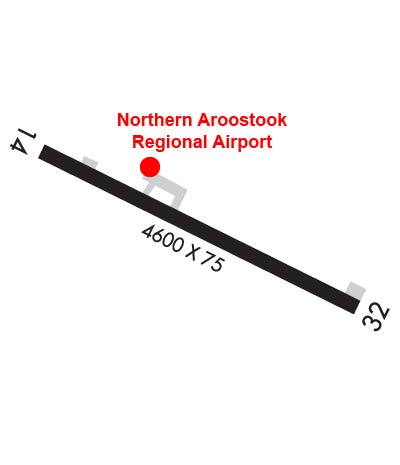
| NORTHERN AROOSTOOK RGNL FRENCHVILLE ME |
| |
| Lat: N 4717.1 Long: W 06818.8 Elev: 987 Var: +18 Longest Runway: 4600 | ||
| AWOS: 135.72 CTAF: 122.7 | ||
| |||||||||||||||||||||||||||||||||||||||||||||||||||||||||||||
| |||||||||||||||||||||||||||||||||||||||||||||||||||||||||||||
| |||||||||||||||||||||||||||||||||||||||||||||||||||||||||||||
| Rwy | Rwy | |||||||
| 4600x75 | 4600' | 4600x75 | 4600' | |||||
| Runway ID | Single Wheel | Double Wheel | Double Tandem Wheel | Dual Double Wheel |
| 14/32 | 25,000 | N/A | N/A | N/A |
| These numbers are Advisory and are not limits. The Airport Manager should have more accurate Weight Limits | ||||
 Airport Diagram might not be current. | |
| Facility Name: | NORTHERN AROOSTOOK RGNL |
| City Name: | FRENCHVILLE |
| County: | AROOSTOOK |
| State abbrev: | ME |
| State Name: | MAINE |
| Ownership: | PUBLICLY OWNED |
| Use: | OPEN TO THE PUBLIC |
| Owner's Name: | N AROOSTOOK RGNL APT AUTH |
| Address: | 74 AIRPORT AVE |
| FRENCHVILLE, ME 04745 | |
| Owner's Phone: | 207-543-6300 |
| Manager's Name: | MATT DEROSIER |
| Address: | 74 AIRPORT AVE |
| FRENCHVILLE, ME 04745 | |
| Phone: | 207-543-6300; AMGR CELL 207-436-0715. EMAIL FRENCHVILLEAIRPORT@GMAIL.COM. |
| FAA Region: | NEW ENGLAND |
| FAA Field Office: | NONE |
| Date | Sunrise | Sunset |
|---|---|---|
| 09/24/21 Friday | 6:22 | 18:27 |
| 09/25/21 Saturday | 6:24 | 18:25 |
| 09/26/21 Sunday | 6:25 | 18:23 |
| 09/27/21 Monday | 6:26 | 18:21 |
| 09/28/21 Tuesday | 6:28 | 18:19 |
| 09/29/21 Wednesday | 6:29 | 18:17 |
| 09/30/21 Thursday | 6:30 | 18:15 |
| 10/01/21 Friday | 6:32 | 18:13 |
| 10/02/21 Saturday | 6:33 | 18:11 |
| 10/03/21 Sunday | 6:34 | 18:09 |
| 10/04/21 Monday | 6:36 | 18:07 |
| 10/05/21 Tuesday | 6:37 | 18:05 |
| 10/06/21 Wednesday | 6:39 | 18:03 |
| 10/07/21 Thursday | 6:40 | 18:01 |
| Airport Attendance Schedule | MON-FRI 0830-1700, SAT-SUN 1000-1600 |
| Airport Status | OPERATIONAL (This Status can change at any time - please check NOTAMS) |
| Airport Lighting Schedule | ACTVT REIL RWY 14 & 32; PAPI RWY 32; MIRL RWY 14/32 - CTAF. |
| Airport Storage Available | Tie Downs, Hanger |
| Extra Services Available | NONE |
| Wind Indicator | YES - (lighted) |
| Control Tower | NO |
| CTAF Frequency | 122.700 |
| Unicom Frequency | 122.700 |
| Rotating Beacon Color | CLEAR-GREEN (Light Land Airport) |
| Segmented Circle | YES |
| Landing Fee | YES |
| Airport Inspected | STATE - performed by PRIVATE CONTRACT PERSONNEL |
| Inspection Date | 08/14/2018 |
| Type of Fuel Available | Grade 100LL, JET A (freeze point -40C); -10FOR FUEL AFT HRS CALL AMGR 207-436-1379. |
| Airframe Repair Service | NONE |
| Power Plant Repair Service | NONE |
| Latitude | N4717.1 |
| Longitude | W06818.8 (ESTIMATED) |
| Arpt Elevation | 987ft (SURVEYED) |
| Magnetic Variation | 18W |
| 3 miles E | of FRENCHVILLE |
| Traffic Pattern Altitude | |
| Sectional Chart | HALIFAX |
| Operations (Reported) | Yearly | Avg. Daily |
|---|---|---|
| General Aviation Transient | 455 | 1 |
| General Aviation Local | 847 | 2 |
| Air Taxi | 6 | 0 |
| Commerical | 0 | 0 |
| Commuter | 0 | 0 |
| Military | 0 | 0 |
| Aircraft based on Field | |
|---|---|
| General Aviation Singles | 10 |
| General Aviation Multi | 0 |
| Jet Aircraft | 0 |
| General Aviation Helicopters | 0 |
| Military Aircraft | 0 |
| Gliders | 0 |
| Ultralights | 0 |
| FSS on field | NO |
| FSS tie-in | BANGOR |
| FSS Phone | 1-800-WX-BRIEF |
| Who issues Notams | FVE |
| Notam D service at airport | YES |
| ARTCC Name | BOSTON |
| Airport Certification | |
| Aircraft Rescue & Firefighting Index | None |
| Airport of Entry | No |
| Custom Landing Rights | YES |
| Joint Civil/Military | No |
| Military Landing rights | YES |
| NATIONAL PLAN OF INTEGRATED AIRPORT SYSTEMS (NPIAS) |
| GRANT AGREEMENTS UNDER FAAP/ADAP/AIP |
| ASSURANCES PURSUANT TO TITLE VI, CIVIL RIGHTS ACT OF 1964 |
| WILDLIFE ON OR INVOF ARPT. |
| FOR CD CTC BOSTON ARTCC AT 603-879-6859. |
Airport Communications & Frequencies:
| |||||||||
| Runway: 14 | Runway: 32 | ||
| Mag heading: | 134° | Mag heading: | 314° |
| Rwy Slope: | .24% Up | Rwy Slope: | -.24% Down |
| Approach: | Approach: | ||
| Pattern: | Left Traffic | Pattern: | Left Traffic |
| Markings: | NONPRECISION INSTRUMENT | Markings: | NONPRECISION INSTRUMENT |
| Marking Condition: | GOOD | Marking Condition: | GOOD |
| Arresting Dev: | Arresting Dev: | ||
| Lat & Long: | N4717.3 W06819.3 | Lat. & Long.: | N4717.0 W06818.3 |
| Elev: | 976.2 ft. MSL | Elev: | 987.1 ft. MSL |
| TCH: | TCH: | 40 ft. AGL | |
| Visual Glide Path: | Visual Glide Path: | 3.00 degrees | |
| Displaced Threshold: | No | Displaced Threshold: | No |
| Touchdown Zone: | YES | Touchdown Zone: | YES |
| Touchdown Elev.: | 983.9 feet | Touchdown Elev.: | 987.2 feet |
| Visual Glide Slope: | Visual Glide Slope: | 4-Light PAPI on LEFT side of Runway | |
| RVR Equipment: | RVR Equipment: | ||
| RVV Equipment: | NO | RVV Equipment: | NO |
| Approach Lights: | Approach Lights: | ||
| REIL: | YES | REIL: | YES |
| Centerline Lights: | NO | Centerline Lights: | NO |
| Touchdown lights: | NO | Touchdown lights: | NO |
| Runway Category: | Runway with a Non-precision Approach | Runway Category: | Runway with a Non-precision Approach |
| Declared Distances: | Declared Distances: | ||
| Obstructions: | TREE | Obstructions: | |
| Marked: | NOT Marked/Lighted | Marked: | |
| Clearance slope: | 36:1 | Clearance slope: | 50:1 |
| Obstruction height: | 53 feet AGL | Obstruction height: | |
| Dist. from runway: | 2110 feet | Dist. from runway: | |
| Centerline offset: | 375 left of centerline | Centerline offset: | |
| Comments: | Comments: |
Thanks for using FltPlan.com
all rights reserved © 1999-2021 by Flight Plan LLC