| VENANGO RGNL FRANKLIN PA |
| |
| Lat: N 4122.6 Long: W 07951.6 Elev: 1540 Var: +10 Longest Runway: 5200 | ||
| Clr Del: 126.25 AWOS: 118.17 CTAF: 122.7 | ||
| |||||||||||||||||||||||||||||||||||||||||||||||||||||||||||||||||||||
| |||||||||||||||||||||||||||||||||||||||||||||||||||||||||||||||||||||
| |||||||||||||||||||||||||||||||||||||||||||||||||||||||||||||||||||||
| Rwy | Rwy | |||||||
| 5200x150 | 5200' | 5200x150 | 5200' | 110.50 - 207° | ||||
| 3593x100 | 3593' | 3593x100 | 3593' | |||||
| Runway ID | Single Wheel | Double Wheel | Double Tandem Wheel | Dual Double Wheel |
| 03/21 | 40,000 | 70,000 | N/A | N/A |
| 12/30 | 67,000 | 105,000 | N/A | N/A |
| These numbers are Advisory and are not limits. The Airport Manager should have more accurate Weight Limits | ||||
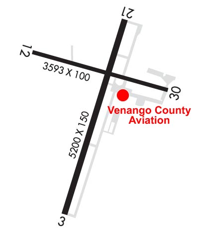 Airport Diagram might not be current. | |
| Facility Name: | VENANGO RGNL |
| City Name: | FRANKLIN |
| County: | VENANGO |
| State abbrev: | PA |
| State Name: | PENNSYLVANIA |
| Ownership: | PUBLICLY OWNED |
| Use: | OPEN TO THE PUBLIC |
| Owner's Name: | VENANGO COUNTY |
| Address: | VENANGO COUNTY COURT HOUSE |
| FRANKLIN, PA 16323 | |
| Owner's Phone: | 814-432-9500 |
| Manager's Name: | BILL R. BUCHNA |
| Address: | 1560 AIRPORT RD |
| FRANKLIN, PA 16323 | |
| Phone: | 814-432-5333 |
| FAA Region: | EASTERN |
| FAA Field Office: | HAR |
| Date | Sunrise | Sunset |
|---|---|---|
| 09/24/21 Friday | 7:09 | 19:14 |
| 09/25/21 Saturday | 7:10 | 19:12 |
| 09/26/21 Sunday | 7:11 | 19:10 |
| 09/27/21 Monday | 7:12 | 19:08 |
| 09/28/21 Tuesday | 7:13 | 19:07 |
| 09/29/21 Wednesday | 7:14 | 19:05 |
| 09/30/21 Thursday | 7:15 | 19:03 |
| 10/01/21 Friday | 7:16 | 19:02 |
| 10/02/21 Saturday | 7:17 | 19:00 |
| 10/03/21 Sunday | 7:18 | 18:58 |
| 10/04/21 Monday | 7:19 | 18:57 |
| 10/05/21 Tuesday | 7:20 | 18:55 |
| 10/06/21 Wednesday | 7:21 | 18:53 |
| 10/07/21 Thursday | 7:22 | 18:52 |
| Airport Attendance Schedule | APR-NOV 7 Days A Week 0700-2100, DEC-MAR MON-FRI 0730-1800, DEC-MAR SAT & SUN 0730-1600 |
| Airport Status | OPERATIONAL (This Status can change at any time - please check NOTAMS) |
| Airport Lighting Schedule | ACTVT HIRL RY 03/21& MALSR RY 21 & MIRL RY 12/30 & TWY LGTS; & PAPI RY 03 & 21 & 30 - CTAF. |
| Airport Storage Available | Tie Downs, Hanger |
| Extra Services Available | Charter, Flight Instruction, Aircraft Rental, Aircraft Sales |
| Wind Indicator | YES - (lighted) |
| Control Tower | NO |
| CTAF Frequency | 122.700 |
| Unicom Frequency | 122.700 |
| Rotating Beacon Color | CLEAR-GREEN (Light Land Airport) |
| Segmented Circle | NO |
| Landing Fee | YES; LANDING FEE FOR ACFT OVER 6000 LBS GROSS WEIGHT. |
| Airport Inspected | FEDERAL - performed by FAA AIRPORTS FIELD PERSONNEL |
| Inspection Date | 06/22/2021 |
| Type of Fuel Available | Grade 100LL, JET A (freeze point -40C) |
| Airframe Repair Service | NONE |
| Power Plant Repair Service | NONE |
| Latitude | N4122.6 |
| Longitude | W07951.6 (ESTIMATED) |
| Arpt Elevation | 1540ft (SURVEYED) |
| Magnetic Variation | 10W |
| 2 miles SW | of FRANKLIN |
| Traffic Pattern Altitude | |
| Sectional Chart | DETROIT |
| Operations (Reported) | Yearly | Avg. Daily |
|---|---|---|
| General Aviation Transient | 14940 | 41 |
| General Aviation Local | 2057 | 6 |
| Air Taxi | 1883 | 5 |
| Commerical | 0 | 0 |
| Commuter | 0 | 0 |
| Military | 56 | 0 |
| Aircraft based on Field | |
|---|---|
| General Aviation Singles | 31 |
| General Aviation Multi | 5 |
| Jet Aircraft | 0 |
| General Aviation Helicopters | 2 |
| Military Aircraft | 0 |
| Gliders | 0 |
| Ultralights | 0 |
| FSS on field | NO |
| FSS tie-in | ALTOONA |
| FSS Phone | 1-800-WX-BRIEF |
| Who issues Notams | FKL |
| Notam D service at airport | YES |
| ARTCC Name | CLEVELAND |
| Airport Certification | AIRPORT RECEIVING SCHEDULED AIR CARRIER SERVICE FROM CARRIERS CERTIFICATED BY THE CIVIL AERONAUTICS BOARD; PPR 24 HRS FOR ACR OPS WITH MORE THAN 30 PSGR SEATS CALL AMGR 814-432-5333 OR 814-758-8002. |
| Aircraft Rescue & Firefighting Index | AIRPORT HAS A CERTIFICATE UNDER CFR PART 139 |
| Airport of Entry | No |
| Custom Landing Rights | No |
| Joint Civil/Military | No |
| Military Landing rights | YES |
| NATIONAL PLAN OF INTEGRATED AIRPORT SYSTEMS (NPIAS) |
| GRANT AGREEMENTS UNDER FAAP/ADAP/AIP |
| ASSURANCES PURSUANT TO TITLE VI, CIVIL RIGHTS ACT OF 1964 |
| COMPLIANCE WITH ACCESSIBILITY TO THE HANDICAPPED |
| DEER AND BIRDS ON & INVOF ARPT. |
| FOR CD CTC YOUNGSTOWN APCH AT 330-856-4806, WHEN APCH CLSD CTC CLEVELAND ARTCC AT 440-774-0234. |
| RWY 12/30 CLSD TO SKED ACR OPS MORE THAN 9 PAX SEATS AND NON SKED ACR OPS MORE THAN 30 PAX SEATS EXC TAX. |
Airport Communications & Frequencies:
| |||||||||||||||||||
| Runway: 03 | Runway: 21 | ||
| Mag heading: | 27° | Mag heading: | 207° |
| Rwy Slope: | .17% Up | Rwy Slope: | -.17% Down |
| Approach: | Approach: | ILS | |
| Pattern: | Left Traffic | Pattern: | Left Traffic |
| Markings: | PRECISION INSTRUMENT | Markings: | PRECISION INSTRUMENT |
| Marking Condition: | GOOD | Marking Condition: | GOOD |
| Arresting Dev: | Arresting Dev: | ||
| Lat & Long: | N4122.2 W07951.8 | Lat. & Long.: | N4123.0 W07951.5 |
| Elev: | 1525.1 ft. MSL | Elev: | 1533.7 ft. MSL |
| TCH: | 45 ft. AGL | TCH: | 55 ft. AGL |
| Visual Glide Path: | 3.00 degrees | Visual Glide Path: | 3.00 degrees |
| Displaced Threshold: | No | Displaced Threshold: | No |
| Touchdown Zone: | YES | Touchdown Zone: | YES |
| Touchdown Elev.: | 1539.1 feet | Touchdown Elev.: | 1539.8 feet |
| Visual Glide Slope: | 4-Light PAPI on LEFT side of Runway | Visual Glide Slope: | 4-Light PAPI on LEFT side of Runway |
| RVR Equipment: | RVR Equipment: | ||
| RVV Equipment: | NO | RVV Equipment: | NO |
| Approach Lights: | Approach Lights: | MALSR - 1,400 foot medium intensity approach lighting system with runway alignment indicator lights | |
| REIL: | NO | REIL: | NO |
| Centerline Lights: | NO | Centerline Lights: | NO |
| Touchdown lights: | NO | Touchdown lights: | NO |
| Runway Category: | Runway with a Non-precision Approach having visibility minimums greater than 3/4 mile | Runway Category: | Precision Instrument Runway |
| Declared Distances: | TORA:5200' TODA:5200' ASDA:5200' LDA:5200' | Declared Distances: | TORA:5200' TODA:5200' ASDA:5200' LDA:5200' |
| Obstructions: | TREES | Obstructions: | TREES |
| Marked: | NOT Marked/Lighted | Marked: | NOT Marked/Lighted |
| Clearance slope: | 17:1 | Clearance slope: | 10:1 |
| Obstruction height: | 91 feet AGL | Obstruction height: | 54 feet AGL |
| Dist. from runway: | 1773 feet | Dist. from runway: | 751 feet |
| Centerline offset: | 490 left of centerline | Centerline offset: | 573 feet right of centerline |
| Comments: | Comments: |
| Runway: 12 | Runway: 30 | ||
| Mag heading: | 116° | Mag heading: | 296° |
| Rwy Slope: | .08% Up | Rwy Slope: | -.08% Down |
| Approach: | Approach: | ||
| Pattern: | Left Traffic | Pattern: | Left Traffic |
| Markings: | BASIC | Markings: | BASIC |
| Marking Condition: | GOOD | Marking Condition: | GOOD |
| Arresting Dev: | Arresting Dev: | ||
| Lat & Long: | N4122.8 W07952.0 | Lat. & Long.: | N4122.7 W07951.2 |
| Elev: | 1529.6 ft. MSL | Elev: | 1532.3 ft. MSL |
| TCH: | TCH: | 41 ft. AGL | |
| Visual Glide Path: | Visual Glide Path: | 3.00 degrees | |
| Displaced Threshold: | No | Displaced Threshold: | No |
| Touchdown Zone: | YES | Touchdown Zone: | YES |
| Touchdown Elev.: | 1540.2 feet | Touchdown Elev.: | 1540.2 feet |
| Visual Glide Slope: | Visual Glide Slope: | 4-Light PAPI on LEFT side of Runway | |
| RVR Equipment: | RVR Equipment: | ||
| RVV Equipment: | NO | RVV Equipment: | NO |
| Approach Lights: | Approach Lights: | ||
| REIL: | NO | REIL: | NO |
| Centerline Lights: | NO | Centerline Lights: | NO |
| Touchdown lights: | NO | Touchdown lights: | NO |
| Runway Category: | Runway with a Visual Approach | Runway Category: | Runway with a Visual Approach |
| Declared Distances: | TORA:3593' TODA:3593' ASDA:3593' LDA:3593' | Declared Distances: | TORA:3593' TODA:3593' ASDA:3593' LDA:3593' |
| Obstructions: | TREES | Obstructions: | |
| Marked: | NOT Marked/Lighted | Marked: | |
| Clearance slope: | 18:1 | Clearance slope: | 20:1 |
| Obstruction height: | 95 feet AGL | Obstruction height: | |
| Dist. from runway: | 1958 feet | Dist. from runway: | |
| Centerline offset: | 171 left of centerline | Centerline offset: | |
| Comments: | Comments: |
Thanks for using FltPlan.com
all rights reserved © 1999-2021 by Flight Plan LLC