
| WRIGHT-PATTERSON AFB DAYTON OH |
| |
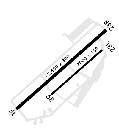
| Lat: N 3949.6 Long: W 08402.8 Elev: 823 Var: +04 Longest Runway: 12600 | ||
| Dept. ATIS: 124.47 Arr. ATIS: 124.47 Ground: 121.8 Tower: 126.9 | ||
| ||||||||||||||||||||||||||||||||
| ||||||||||||||||||||||||||||||||
| ||||||||||||||||||||||||||||||||
| Rwy | Rwy | |||||||
| 12600x300 | 12600' | 109.70 - 052° | 12600x300 | 12600' | 109.70 - 233° | |||
| 7000x150 | 7000' | 7000x150 | 7000' | |||||
| Runway ID | Single Wheel | Double Wheel | Double Tandem Wheel | Dual Double Wheel |
| 05L/23R | N/A | N/A | N/A | N/A |
| 05R/23L | N/A | N/A | N/A | N/A |
| These numbers are Advisory and are not limits. The Airport Manager should have more accurate Weight Limits | ||||
 Airport Diagram might not be current. | |
| Facility Name: | WRIGHT-PATTERSON AFB |
| City Name: | DAYTON |
| County: | GREENE |
| State abbrev: | OH |
| State Name: | OHIO |
| Ownership: | AIR FORCE OWNED |
| Use: | PRIVATE |
| Owner's Name: | US AIR FORCE |
| Address: | WRIGHT-PATTERSON AFB |
| DAYTON, OH 45433 | |
| Owner's Phone: | 937-257-2131 |
| Manager's Name: | BASE COMMANDER; AIRFIELD MANAGER - ROMULO ALCANTARA 937-257-6206 |
| Address: | WRIGHT PATTERSON AFB |
| DAYTON, OH 45433 | |
| Phone: | 937-257-2131 |
| FAA Region: | GREAT LAKES |
| FAA Field Office: | DET |
| Date | Sunrise | Sunset |
|---|---|---|
| 09/24/21 Friday | 7:25 | 19:30 |
| 09/25/21 Saturday | 7:26 | 19:29 |
| 09/26/21 Sunday | 7:27 | 19:27 |
| 09/27/21 Monday | 7:28 | 19:25 |
| 09/28/21 Tuesday | 7:29 | 19:24 |
| 09/29/21 Wednesday | 7:30 | 19:22 |
| 09/30/21 Thursday | 7:31 | 19:21 |
| 10/01/21 Friday | 7:32 | 19:19 |
| 10/02/21 Saturday | 7:33 | 19:17 |
| 10/03/21 Sunday | 7:34 | 19:16 |
| 10/04/21 Monday | 7:35 | 19:14 |
| 10/05/21 Tuesday | 7:36 | 19:13 |
| 10/06/21 Wednesday | 7:37 | 19:11 |
| 10/07/21 Thursday | 7:38 | 19:09 |
| Airport Attendance Schedule | CONTINUOUS; SEE FLIP AP/1 SUPPLEMENTARY ARPT |
| Airport Status | OPERATIONAL (This Status can change at any time - please check NOTAMS) |
| Airport Lighting Schedule | |
| Airport Storage Available | Hanger |
| Extra Services Available | Cargo Handling |
| Wind Indicator | YES - (unlit) |
| Control Tower | YES |
| CTAF Frequency | |
| Unicom Frequency | |
| Rotating Beacon Color | CLEAR-GREEN (Light Land Airport) |
| Segmented Circle | NO |
| Landing Fee | NO |
| Airport Inspected | No Inspection Data Available performed by the OWNER |
| Inspection Date | Unknown |
| Type of Fuel Available | None |
| Airframe Repair Service | MAJOR |
| Power Plant Repair Service | MAJOR |
| Latitude | N3949.6 |
| Longitude | W08402.8 (ESTIMATED) |
| Arpt Elevation | 823ft (SURVEYED) |
| Magnetic Variation | 04W |
| 8 miles NE | of DAYTON |
| Traffic Pattern Altitude | RECTANGULAR FIGHTER/TACTICAL/TRAINER ACFT 2400' MSL, OTHER TURBOJET/TURBOPROP AND LGT RECIPROCATING ENG ACFT (12,500 LB OR BLW GWT) 1900', OVERHEAD 2400' MSL. |
| Sectional Chart | CINCINNATI |
| Operations (Reported) | Yearly | Avg. Daily |
|---|---|---|
| General Aviation Transient | 0 | 0 |
| General Aviation Local | 0 | 0 |
| Air Taxi | 0 | 0 |
| Commerical | 0 | 0 |
| Commuter | 0 | 0 |
| Military | 0 | 0 |
| Aircraft based on Field | |
|---|---|
| General Aviation Singles | 0 |
| General Aviation Multi | 0 |
| Jet Aircraft | 0 |
| General Aviation Helicopters | 0 |
| Military Aircraft | 9 |
| Gliders | 0 |
| Ultralights | 0 |
| FSS on field | NO |
| FSS tie-in | DAYTON |
| FSS Phone | 1-800-WX-BRIEF |
| Who issues Notams | FFO |
| Notam D service at airport | YES |
| ARTCC Name | INDIANAPOLIS |
| Airport Certification | |
| Aircraft Rescue & Firefighting Index | ARFF STATUS: KFFO IS A SET/CAT 4 BASE. |
| Airport of Entry | No |
| Custom Landing Rights | No |
| Joint Civil/Military | No |
| Military Landing rights | No |
| CAUTION: UNLGTD OBST SUR AFLD. |
| CAUTION: BIRD WATCH CONDITION PHASE I (NOV-JUN) INDICATES LGT BIRD ACT, PHASE II (JUL-OCT) INDICATES HVY BIRD ACT NML ASSOCIATED WITH MIGRATORY SEASON. |
| MISC: UNLGTD ABANDONED TWR W SIDE FLD. |
| MISC: AMOPS DSN 787-2131, C937-257-2131. |
| AFRC: 445 AW OPR 1200--0330Z++. MON-FRI AND TRNG WKEND. |
| CSTMS/AG/IMG: LTD CSTMS AVBL. U.S. MIL REQ A MINIMUM OF 24 HR PN, FOREIGN STATE ACFT A MIN OF 48 HR PN CALL AMOPS DSN 787-2131, C937-257-2131 |
| JASU: 7(A/M32A-86) 1(MC-1A) 4(AM32-95) 7(A/M32A-60/A). |
| FUEL: A++ |
| FLUID: SP PRESAIR LHOX LOX. |
| OIL: O-148-156 SOAP/JOAP AVBL 1230-2130Z++WKD EXC CLSD WKEND AND HOL. |
| TRAN ALERT: OPR 1100-0300Z++; AVBL OT WITH 24 HR PN TO AFLD OPS. FLEET SVC IS A CONTRACTED CO AND AVBL WITH 3 HR PN. PRIOR PAYMENT RQR BY AVCARD. |
| MISC: STD RSRS APPLIED. |
| RSTD: ARPT PPR. CTC AFLD OPS C937-257-2131, DSN 787-2131. |
| CAUTION: PORTIONS OF FLAMEOUT & OVERHEAD TFC PAT NOT VIS FM TWR. |
| TRANS ALERT: PAX TRML IS CONTRACTED. ALL AIRCREWS RQRG SUPPORT MUST COORD PRIOR TO ARR/DEP NML DUTY HR M-F 1130-2030Z++ DSN: 787-7741/COMM: 937-257-7741 OR AFTER HR DUTY CELL: 937-815-6995. |
| RSTD: INBD ACFT WITH VIP CTC AFLD OPS ON PTD 30 MIN PRIOR TO ARR. |
| SERVICE-LGT: INST HOLD SIGNS AND RWY GUARD LGTS AT INT OF TWY A AND APCH END OF RWY 23R UNSVC. |
| MISC: LTD COMSEC STORAGE AVBL, PRIOR COORD RQR WITH AMOPS. |
| CAUTION: RY 23R CNTRLN MARK OBSC BY RUBBER DEPOSITS. |
| NS ABTMT: QUIET HRS 0300-1000Z++: ONLY INITIAL DEP/FULL-STOP LDG PERMITTED; FROM 0300-0500Z++ ALL TRNG FLTS BTN THESE HRS HELD TO ABSOLUTE MIN FOR MISSION REQUIREMENT. ALL REQ COORD THRU AMOPS WITH 88 OSS/CC APVL, AT DSN 787-2131, C937-257-2131. |
| CAUTION: NVD OPS IN PROGRESS TUE-THU SS-0400Z++. CHECK NOTAM AND ATIS FOR CURRENT OPS. WHEN NVD OPR ARE IN EFFECT, NON-PARTICIPATING ACFT CTC TWR 20 MILES OR 15 MINS PRIOR TO ENTERING CLASS D AIRSPACE AND FOR AFLD LGT ADJUSTMENT. |
| CAUTION: RECREATIONAL REMOTE CTL ACFT OPS BLO 400 FT AGL INVOF ARPT 4 NM SW OF FFO TACAN, DLY SR-SS; CK ATIS FOR CURRENT OPS. |
| CAUTION: INCREASED POTENTIAL FOR HYDROPLANING ON RWY 05R/23L MAY OCCUR DUE TO PONDING DUR HVY RAIN. |
| ARFF STATUS: KFFO IS A SET/CAT 4 BASE. |
| CAUTION: RWYCC NOT RPT. |
| MISC: EXP DEP FR RY 23R AT TWY 'B' INT 11,600 FT AVBL; IF FULL LEN RQR, RQ BACK-TAXI FM TWR. |
| RWY 05L/ 23RFIRST 2600 FT RY 05L CONC. |
Airport Communications & Frequencies:
| |||||||||||||||||||||||||||||||||||||||
| Runway: 05L | Runway: 23R | ||
| Mag heading: | N/A | Mag heading: | N/A |
| Rwy Slope: | .15% Up | Rwy Slope: | -.15% Down |
| Approach: | ILS | Approach: | ILS |
| Pattern: | Left Traffic | Pattern: | Right Traffic |
| Markings: | PRECISION INSTRUMENT | Markings: | PRECISION INSTRUMENT |
| Marking Condition: | GOOD | Marking Condition: | GOOD |
| Arresting Dev: | BAK-12B,BAK-14; TYPE-H BAK-12B(B) (1676 FT). | Arresting Dev: | BAK-12B,BAK-14; BAK-14 BAK-12B(B) (1740 FT); INCRD TAILHOOK SKIP POTENTIAL. |
| Lat & Long: | N3948.9 W08403.9 | Lat. & Long.: | N3950.3 W08401.9 |
| Elev: | 803.7 ft. MSL | Elev: | 822.5 ft. MSL |
| TCH: | 51 ft. AGL | TCH: | 53 ft. AGL |
| Visual Glide Path: | 3.00 degrees | Visual Glide Path: | 3.00 degrees |
| Displaced Threshold: | No | Displaced Threshold: | No |
| Touchdown Zone: | YES | Touchdown Zone: | YES |
| Touchdown Elev.: | 804.7 feet | Touchdown Elev.: | 823.3 feet |
| Visual Glide Slope: | 4-Light PAPI on LEFT side of Runway | Visual Glide Slope: | 4-Light PAPI on RIGHT side of Runway |
| RVR Equipment: | TOUCHDOWN | RVR Equipment: | TOUCHDOWN |
| RVV Equipment: | YES | RVV Equipment: | YES |
| Approach Lights: | ALSF1 - standard 2,400 foot high intensity approach lighting system with sequenced flashers, Category I | Approach Lights: | ALSF1 - standard 2,400 foot high intensity approach lighting system with sequenced flashers, Category I |
| REIL: | NO | REIL: | NO |
| Centerline Lights: | NO | Centerline Lights: | NO |
| Touchdown lights: | NO | Touchdown lights: | NO |
| Runway Category: | Runway Category: | ||
| Declared Distances: | Declared Distances: |
| Runway: 05R | Runway: 23L | ||
| Mag heading: | N/A | Mag heading: | N/A |
| Rwy Slope: | .16% Up | Rwy Slope: | -.16% Down |
| Approach: | Approach: | ||
| Pattern: | Left Traffic | Pattern: | Left Traffic |
| Markings: | Markings: | ||
| Marking Condition: | Marking Condition: | ||
| Arresting Dev: | Arresting Dev: | ||
| Lat & Long: | N3949.1 W08403.1 | Lat. & Long.: | N3949.9 W08402.0 |
| Elev: | 807.3 ft. MSL | Elev: | 818.2 ft. MSL |
| TCH: | 51 ft. AGL | TCH: | 50 ft. AGL |
| Visual Glide Path: | 3.00 degrees | Visual Glide Path: | 3.00 degrees |
| Displaced Threshold: | No | Displaced Threshold: | No |
| Touchdown Zone: | YES | Touchdown Zone: | YES |
| Touchdown Elev.: | 812.7 feet | Touchdown Elev.: | 818.2 feet |
| Visual Glide Slope: | 4-Light PAPI on LEFT side of Runway | Visual Glide Slope: | 4-Light PAPI on LEFT side of Runway |
| RVR Equipment: | RVR Equipment: | ||
| RVV Equipment: | NO | RVV Equipment: | NO |
| Approach Lights: | Approach Lights: | ||
| REIL: | NO | REIL: | NO |
| Centerline Lights: | NO | Centerline Lights: | NO |
| Touchdown lights: | NO | Touchdown lights: | NO |
| Runway Category: | Runway Category: | ||
| Declared Distances: | Declared Distances: |
Thanks for using FltPlan.com
all rights reserved © 1999-2021 by Flight Plan LLC
