
| UNION PARISH FARMERVILLE LA |
| |
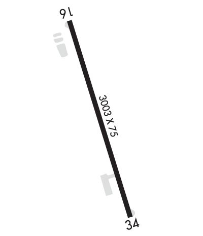
| Lat: N 3243.5 Long: W 09220.2 Elev: 121 Var: -05 Longest Runway: 3003 | ||
| CTAF: 122.9 | ||
| ||||||||||||||||||||||||||||||||||||||||||||
| ||||||||||||||||||||||||||||||||||||||||||||
| Rwy | Rwy | |||||||
| 3003x75 | 3003' | 3003x75 | 3003' | |||||
| Runway ID | Single Wheel | Double Wheel | Double Tandem Wheel | Dual Double Wheel |
| 16/34 | 8,000 | N/A | N/A | N/A |
| These numbers are Advisory and are not limits. The Airport Manager should have more accurate Weight Limits | ||||
| FltPlan does not have IFR approach charts available for KF87. |
 Airport Diagram might not be current. | |
| Facility Name: | UNION PARISH |
| City Name: | FARMERVILLE |
| County: | UNION |
| State abbrev: | LA |
| State Name: | LOUISIANA |
| Ownership: | PUBLICLY OWNED |
| Use: | OPEN TO THE PUBLIC |
| Owner's Name: | UNION PARISH POLICE JURY |
| Address: | PO BOX 723 |
| FARMERVILLE, LA 71241 | |
| Owner's Phone: | 318-368-3296 |
| Manager's Name: | NICHOLAS GREEN; EMAIL: BEECHCRAFT32J@GMAIL.COM. |
| Address: | 152 AIRPORT DRIVE |
| FARMERVILLE, LA 71241 | |
| Phone: | 318-243-4155 |
| FAA Region: | SOUTHWEST |
| FAA Field Office: | LNM |
| Date | Sunrise | Sunset |
|---|---|---|
| 09/24/21 Friday | 6:59 | 19:04 |
| 09/25/21 Saturday | 6:59 | 19:02 |
| 09/26/21 Sunday | 7:00 | 19:01 |
| 09/27/21 Monday | 7:01 | 19:00 |
| 09/28/21 Tuesday | 7:01 | 18:58 |
| 09/29/21 Wednesday | 7:02 | 18:57 |
| 09/30/21 Thursday | 7:03 | 18:56 |
| 10/01/21 Friday | 7:03 | 18:54 |
| 10/02/21 Saturday | 7:04 | 18:53 |
| 10/03/21 Sunday | 7:05 | 18:52 |
| 10/04/21 Monday | 7:05 | 18:50 |
| 10/05/21 Tuesday | 7:06 | 18:49 |
| 10/06/21 Wednesday | 7:07 | 18:48 |
| 10/07/21 Thursday | 7:07 | 18:46 |
| Airport Attendance Schedule | UNATTENDED |
| Airport Status | OPERATIONAL (This Status can change at any time - please check NOTAMS) |
| Airport Lighting Schedule | MIRL RY 16/34, REIL RYS 16 & 34 PRESET LOW INTST DUSK-DAWN; TO INCR INTST ACTVT - CTAF. |
| Airport Storage Available | Tie Downs |
| Extra Services Available | NONE |
| Wind Indicator | YES - (lighted) |
| Control Tower | NO |
| CTAF Frequency | 122.900 |
| Unicom Frequency | |
| Rotating Beacon Color | CLEAR-GREEN (Light Land Airport) |
| Segmented Circle | NO |
| Landing Fee | NO |
| Airport Inspected | STATE - performed by STATE AERONAUTICAL PERSONNEL |
| Inspection Date | 12/09/2020 |
| Type of Fuel Available | Grade 100LL; -10FUEL AVBL WITH CASH ONLY. |
| Airframe Repair Service | NONE |
| Power Plant Repair Service | NONE |
| Latitude | N3243.5 |
| Longitude | W09220.2 (ESTIMATED) |
| Arpt Elevation | 121ft (SURVEYED) |
| Magnetic Variation | 05E |
| 4 miles SE | of FARMERVILLE |
| Traffic Pattern Altitude | |
| Sectional Chart | MEMPHIS |
| Operations (Reported) | Yearly | Avg. Daily |
|---|---|---|
| General Aviation Transient | 3500 | 10 |
| General Aviation Local | 12000 | 33 |
| Air Taxi | 0 | 0 |
| Commerical | 0 | 0 |
| Commuter | 0 | 0 |
| Military | 0 | 0 |
| Aircraft based on Field | |
|---|---|
| General Aviation Singles | 22 |
| General Aviation Multi | 0 |
| Jet Aircraft | 0 |
| General Aviation Helicopters | 0 |
| Military Aircraft | 0 |
| Gliders | 0 |
| Ultralights | 0 |
| FSS on field | NO |
| FSS tie-in | DE RIDDER |
| FSS Phone | 1-800-WX-BRIEF |
| Who issues Notams | DRI |
| Notam D service at airport | YES |
| ARTCC Name | FORT WORTH |
| Airport Certification | |
| Aircraft Rescue & Firefighting Index | None |
| Airport of Entry | No |
| Custom Landing Rights | No |
| Joint Civil/Military | No |
| Military Landing rights | No |
| NATIONAL PLAN OF INTEGRATED AIRPORT SYSTEMS (NPIAS) |
| THIS AIRPORT HAS BEEN SURVEYED BY THE NATIONAL GEODETIC SURVEY. |
| OXIDATION POND WITH 6 FT FENCE 150 FT WEST OF CNTRLN ON THE NORTH END OF RY 16. |
| FOR CD CTC MONROE APCH AT 318-327-5641, IF UNAVBL, CTC FORT WORTH ARTCC AT 817-858-7584. |
| RWY 16/3 4 RY CLSD TO ACFT OVER 12,500 LBS. |
| Runway: 16 | Runway: 34 | ||
| Mag heading: | 158° | Mag heading: | 338° |
| Rwy Slope: | .11% Up | Rwy Slope: | -.11% Down |
| Approach: | Approach: | ||
| Pattern: | Left Traffic | Pattern: | Left Traffic |
| Markings: | NONPRECISION INSTRUMENT | Markings: | NONPRECISION INSTRUMENT |
| Marking Condition: | GOOD | Marking Condition: | GOOD |
| Arresting Dev: | Arresting Dev: | ||
| Lat & Long: | N3243.7 W09220.3 | Lat. & Long.: | N3243.3 W09220.1 |
| Elev: | 117.8 ft. MSL | Elev: | 121.0 ft. MSL |
| TCH: | 63 ft. AGL | TCH: | 50 ft. AGL |
| Visual Glide Path: | 3.83 degrees | Visual Glide Path: | 3.00 degrees |
| Displaced Threshold: | No | Displaced Threshold: | No |
| Touchdown Zone: | YES | Touchdown Zone: | YES |
| Touchdown Elev.: | 121.0 feet | Touchdown Elev.: | 121.0 feet |
| Visual Glide Slope: | 2-Light PAPI on LEFT side of Runway | Visual Glide Slope: | 2-Light PAPI on LEFT side of Runway |
| RVR Equipment: | RVR Equipment: | ||
| RVV Equipment: | NO | RVV Equipment: | NO |
| Approach Lights: | Approach Lights: | ||
| REIL: | YES | REIL: | YES |
| Centerline Lights: | NO | Centerline Lights: | NO |
| Touchdown lights: | NO | Touchdown lights: | NO |
| Runway Category: | Runway with a Visual Approach | Runway Category: | Runway with a Visual Approach |
| Declared Distances: | Declared Distances: | ||
| Obstructions: | TREES | Obstructions: | TREES |
| Marked: | NOT Marked/Lighted | Marked: | NOT Marked/Lighted |
| Clearance slope: | 13:1 | Clearance slope: | 21:1 |
| Obstruction height: | 75 feet AGL | Obstruction height: | 52 feet AGL |
| Dist. from runway: | 1215 feet | Dist. from runway: | 1310 feet |
| Centerline offset: | 252 left of centerline | Centerline offset: | 182 feet left of centerline |
| Comments: | Comments: |
Thanks for using FltPlan.com
all rights reserved © 1999-2021 by Flight Plan LLC
