
| KENOSHA RGNL KENOSHA WI |
| |
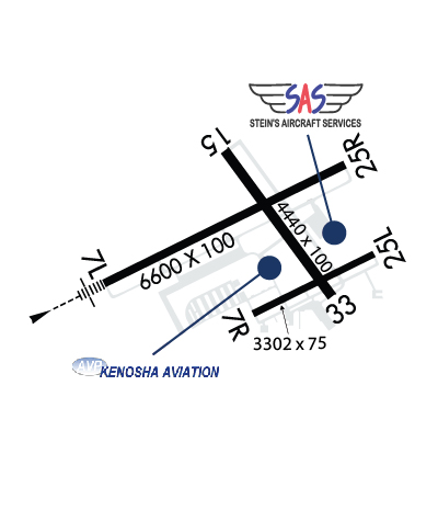
| Lat: N 4235.8 Long: W 08755.6 Elev: 743 Var: +02 Longest Runway: 6600 | ||
| Clr Del: 118.6 Dept. ATIS: 127.17 Arr. ATIS: 127.17 AWOS: 127.17 Ground: 121.87 Tower: 118.6 | ||
| |||||||||||||||||||||||||||||||||||||||||||||||||||||||||||||||||||||
| |||||||||||||||||||||||||||||||||||||||||||||||||||||||||||||||||||||
| |||||||||||||||||||||||||||||||||||||||||||||||||||||||||||||||||||||
| |||||||||||||||||||||||||||||||||||||||||||||||||||||||||||||||||||||
| Rwy | Rwy | |||||||
| 6600x100 | 6600' | 109.35 - 067° | 6600x100 | 6600' | ||||
| 3302x75 | 3302' | 3302x75 | 3302' | |||||
| 4440x100 | 4440' | 4440x100 | 4440' | |||||
| Runway ID | Single Wheel | Double Wheel | Double Tandem Wheel | Dual Double Wheel |
| 07L/25R | 108,000 | 135,000 | 209,000 | N/A |
| 07R/25L | 40,000 | 48,000 | N/A | N/A |
| 15/33 | 62,000 | 73,000 | 135,000 | N/A |
| These numbers are Advisory and are not limits. The Airport Manager should have more accurate Weight Limits | ||||
 Airport Diagram might not be current. | |
| Facility Name: | KENOSHA RGNL |
| City Name: | KENOSHA |
| County: | KENOSHA |
| State abbrev: | WI |
| State Name: | WISCONSIN |
| Ownership: | PUBLICLY OWNED |
| Use: | OPEN TO THE PUBLIC |
| Owner's Name: | CITY OF KENOSHA |
| Address: | 625 52ND ST |
| KENOSHA, WI 53140 | |
| Owner's Phone: | (262) 653-4159 |
| Manager's Name: | COREY REED |
| Address: | 9900 52ND ST |
| KENOSHA, WI 53144 | |
| Phone: | 262-653-4161 |
| FAA Region: | GREAT LAKES |
| FAA Field Office: | CHI |
| Date | Sunrise | Sunset |
|---|---|---|
| 12/13/25 Saturday | 7:13 | 16:19 |
| 12/14/25 Sunday | 7:14 | 16:19 |
| 12/15/25 Monday | 7:15 | 16:19 |
| 12/16/25 Tuesday | 7:15 | 16:19 |
| 12/17/25 Wednesday | 7:16 | 16:20 |
| 12/18/25 Thursday | 7:17 | 16:20 |
| 12/19/25 Friday | 7:17 | 16:20 |
| 12/20/25 Saturday | 7:18 | 16:21 |
| 12/21/25 Sunday | 7:18 | 16:21 |
| 12/22/25 Monday | 7:19 | 16:22 |
| 12/23/25 Tuesday | 7:19 | 16:22 |
| 12/24/25 Wednesday | 7:20 | 16:23 |
| 12/25/25 Thursday | 7:20 | 16:24 |
| 12/26/25 Friday | 7:20 | 16:24 |
| Airport Attendance Schedule | 7 Days A Week 0700-2100 |
| Airport Status | OPERATIONAL (This Status can change at any time - please check NOTAMS) |
| Airport Lighting Schedule | WHEN ATCT CLSD, HIRL RWY 07L/25R PRESET ON LOW INTST; TO INCR INTST & ACTVT MALSR RWY 07L; REIL RWY 25R; PAPI RWY 07L, 07R, 25L & 25R; HIRL RWY 07L/25R; HIRL RWY 15/33; MIRL RWY 07R/25L - CTAF. VASI RWY 15 & 33 OPRS CONSLY. |
| Airport Storage Available | Tie Downs, Hanger |
| Extra Services Available | Avionics, Cargo Handling, Charter, Flight Instruction, Aircraft Rental, Aircraft Sales |
| Wind Indicator | YES - (unlit) |
| Control Tower | YES |
| CTAF Frequency | 118.600 |
| Unicom Frequency | 122.950 |
| Rotating Beacon Color | WG |
| Segmented Circle | YES |
| Landing Fee | NO |
| Airport Inspected | FEDERAL - performed by STATE AERONAUTICAL PERSONNEL |
| Inspection Date | 09/24/2025 |
| Type of Fuel Available | Grade 100LL, JET A |
| Airframe Repair Service | MAJOR |
| Power Plant Repair Service | MAJOR |
| Latitude | N4235.8 |
| Longitude | W08755.6 (ESTIMATED) |
| Arpt Elevation | 742ft (SURVEYED) |
| Magnetic Variation | 02W |
| 4 miles W | of KENOSHA |
| Traffic Pattern Altitude | |
| Sectional Chart | CHICAGO |
| Operations (Reported) | Yearly | Avg. Daily |
|---|---|---|
| General Aviation Transient | 0 | 0 |
| General Aviation Local | 0 | 0 |
| Air Taxi | 0 | 0 |
| Commerical | 0 | 0 |
| Commuter | 0 | 0 |
| Military | 0 | 0 |
| Aircraft based on Field | |
|---|---|
| General Aviation Singles | 0 |
| General Aviation Multi | 0 |
| Jet Aircraft | 0 |
| General Aviation Helicopters | 0 |
| Military Aircraft | 0 |
| Gliders | 0 |
| Ultralights | 0 |
| FSS on field | NO |
| FSS tie-in | GREEN BAY |
| FSS Phone | 1-800-WX-BRIEF |
| Who issues Notams | ENW |
| Notam D service at airport | YES |
| ARTCC Name | CHICAGO |
| Airport Certification | |
| Aircraft Rescue & Firefighting Index | None |
| Airport of Entry | No |
| Custom Landing Rights | No |
| Joint Civil/Military | No |
| Military Landing rights | YES |
| NATIONAL PLAN OF INTEGRATED AIRPORT SYSTEMS (NPIAS) |
| GRANT AGREEMENTS UNDER FAAP/ADAP/AIP |
| ASSURANCES PURSUANT TO TITLE VI, CIVIL RIGHTS ACT OF 1964 |
| BIRDS ON & INVOF ARPT. |
| HELICOPTER DEP & ARR OPS WILL BE AUTH BY ATC FM MOVEMENT AREAS ONLY. NON-MOVEMENT AREA DEPS, ARRS & PRACTICE, ARE PROHIBITED. |
| ACFT WEIGHING MORE THAN 122,000 LBS, EMPTY OR FULLY LOADED, ARE NOT ALLOWED TO BE BASED AT KENW. THE TERM BASED SHALL BE DEFINED AS AN ACFT THAT IS OPR & AIRWORTHY ON THE ARPT FOR A MAJORITY OF THE YEAR. |
| RWY 07R/ 25LCLSD TO JET ACFT & ACFT WEIGHING MORE THAN 12500 LBS WHEN RWY 07L/25R IS OPEN. |
| RWY 07L/ 25RPCR VALUE: 430/R/D/W/T |
Airport Communications & Frequencies:
| ||||||||||||||||||||||||||
| Runway: 07L | Runway: 25R | ||
| Mag heading: | 66° | Mag heading: | 246° |
| Rwy Slope: | -.54% Down | Rwy Slope: | .54% Up |
| Approach: | ILS | Approach: | |
| Pattern: | Left Traffic | Pattern: | Right Traffic |
| Markings: | PRECISION INSTRUMENT | Markings: | PRECISION INSTRUMENT |
| Marking Condition: | GOOD | Marking Condition: | GOOD |
| Arresting Dev: | Arresting Dev: | ||
| Lat & Long: | N4235.6 W08756.5 | Lat. & Long.: | N4236.1 W08755.2 |
| Elev: | 742.6 ft. MSL | Elev: | 707.2 ft. MSL |
| TCH: | 55 ft. AGL | TCH: | 45 ft. AGL |
| Visual Glide Path: | 3.00 degrees | Visual Glide Path: | 3.00 degrees |
| Displaced Threshold: | No | Displaced Threshold: | No |
| Touchdown Zone: | YES | Touchdown Zone: | YES |
| Touchdown Elev.: | 742.6 feet | Touchdown Elev.: | 723.0 feet |
| Visual Glide Slope: | 4-Light PAPI on LEFT side of Runway | Visual Glide Slope: | 4-Light PAPI on LEFT side of Runway |
| RVR Equipment: | RVR Equipment: | ||
| RVV Equipment: | NO | RVV Equipment: | NO |
| Approach Lights: | MALSR - 1,400 foot medium intensity approach lighting system with runway alignment indicator lights | Approach Lights: | |
| REIL: | NO | REIL: | YES |
| Centerline Lights: | NO | Centerline Lights: | NO |
| Touchdown lights: | NO | Touchdown lights: | NO |
| Runway Category: | Precision Instrument Runway | Runway Category: | D |
| Declared Distances: | Declared Distances: |
| Runway: 07R | Runway: 25L | ||
| Mag heading: | 66° | Mag heading: | 246° |
| Rwy Slope: | -.70% Down | Rwy Slope: | .70% Up |
| Approach: | Approach: | ||
| Pattern: | Right Traffic | Pattern: | Left Traffic |
| Markings: | BASIC | Markings: | BASIC |
| Marking Condition: | FAIR | Marking Condition: | FAIR |
| Arresting Dev: | Arresting Dev: | ||
| Lat & Long: | N4235.5 W08755.7 | Lat. & Long.: | N4235.7 W08755.0 |
| Elev: | 729.3 ft. MSL | Elev: | 706.1 ft. MSL |
| TCH: | 26 ft. AGL | TCH: | 24 ft. AGL |
| Visual Glide Path: | 3.00 degrees | Visual Glide Path: | 3.00 degrees |
| Displaced Threshold: | No | Displaced Threshold: | No |
| Touchdown Zone: | YES | Touchdown Zone: | YES |
| Touchdown Elev.: | 729.3 feet | Touchdown Elev.: | 727.8 feet |
| Visual Glide Slope: | 4-Light PAPI on LEFT side of Runway | Visual Glide Slope: | 4-Light PAPI on LEFT side of Runway; PAPI UNUSBL BYD 7 DEGS RIGHT OF CNTRLN. |
| RVR Equipment: | RVR Equipment: | ||
| RVV Equipment: | NO | RVV Equipment: | NO |
| Approach Lights: | Approach Lights: | ||
| REIL: | NO | REIL: | NO |
| Centerline Lights: | NO | Centerline Lights: | NO |
| Touchdown lights: | NO | Touchdown lights: | NO |
| Runway Category: | Runway with a Visual Approach | Runway Category: | Runway with a Visual Approach |
| Declared Distances: | Declared Distances: | ||
| Obstructions: | Obstructions: | TREES | |
| Marked: | Marked: | NOT Marked/Lighted | |
| Clearance slope: | 20:1 | Clearance slope: | 19:1 |
| Obstruction height: | Obstruction height: | 34 feet AGL | |
| Dist. from runway: | Dist. from runway: | 850 feet | |
| Centerline offset: | Centerline offset: | 25 feet left of centerline | |
| Comments: | Comments: |
| Runway: 15 | Runway: 33 | ||
| Mag heading: | 146° | Mag heading: | 326° |
| Rwy Slope: | -.03% Down | Rwy Slope: | .03% Up |
| Approach: | Approach: | ||
| Pattern: | Left Traffic | Pattern: | Left Traffic |
| Markings: | NONPRECISION INSTRUMENT | Markings: | NONPRECISION INSTRUMENT |
| Marking Condition: | GOOD | Marking Condition: | GOOD |
| Arresting Dev: | Arresting Dev: | ||
| Lat & Long: | N4236.1 W08755.8 | Lat. & Long.: | N4235.5 W08755.3 |
| Elev: | 716.2 ft. MSL | Elev: | 714.9 ft. MSL |
| TCH: | 50 ft. AGL | TCH: | 42 ft. AGL |
| Visual Glide Path: | 4.00 degrees | Visual Glide Path: | 3.00 degrees |
| Displaced Threshold: | No | Displaced Threshold: | No |
| Touchdown Zone: | YES | Touchdown Zone: | YES |
| Touchdown Elev.: | 720.6 feet | Touchdown Elev.: | 720.6 feet |
| Visual Glide Slope: | 4-BOX VASI ON LEFT SIDE OF RUNWAY | Visual Glide Slope: | 4-BOX VASI ON LEFT SIDE OF RUNWAY |
| RVR Equipment: | RVR Equipment: | ||
| RVV Equipment: | NO | RVV Equipment: | NO |
| Approach Lights: | Approach Lights: | ||
| REIL: | NO | REIL: | NO |
| Centerline Lights: | NO | Centerline Lights: | NO |
| Touchdown lights: | NO | Touchdown lights: | NO |
| Runway Category: | Runway with a Non-precision Approach having visibility minimums greater than 3/4 mile | Runway Category: | Runway with a Non-precision Approach having visibility minimums greater than 3/4 mile |
| Declared Distances: | Declared Distances: | ||
| Obstructions: | TREES | Obstructions: | |
| Marked: | NOT Marked/Lighted | Marked: | |
| Clearance slope: | 16:1 | Clearance slope: | 34:1 |
| Obstruction height: | 58 feet AGL | Obstruction height: | |
| Dist. from runway: | 1150 feet | Dist. from runway: | |
| Centerline offset: | 270 left of centerline | Centerline offset: | |
| Comments: | Comments: |
Thanks for using FltPlan.com
all rights reserved © 1999-2025 by Flight Plan LLC