
| ELKHART-MORTON COUNTY ELKHART KS |
| |
| Lat: N 3700.0 Long: W 10152.8 Elev: 3622 Var: -07 Longest Runway: 4907 | ||
| AWOS: 118.02 CTAF: 122.8 | ||
| ||||||||||||||||||||||||||||||||||||||||||||
| ||||||||||||||||||||||||||||||||||||||||||||
| ||||||||||||||||||||||||||||||||||||||||||||
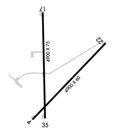
| Rwy | Rwy | |||||||
| 4900x60 | 4900' | 4900x60 | 4900' | |||||
| 4907x75 | 4907' | 4907x75 | 4907' | |||||
| Runway ID | Single Wheel | Double Wheel | Double Tandem Wheel | Dual Double Wheel |
| 04/22 | N/A | N/A | N/A | N/A |
| 17/35 | 30,000 | 30,000 | N/A | N/A |
| These numbers are Advisory and are not limits. The Airport Manager should have more accurate Weight Limits | ||||
 Airport Diagram might not be current. | |
| Facility Name: | ELKHART-MORTON COUNTY |
| City Name: | ELKHART |
| County: | MORTON |
| State abbrev: | KS |
| State Name: | KANSAS |
| Ownership: | PUBLICLY OWNED |
| Use: | OPEN TO THE PUBLIC |
| Owner's Name: | MORTON COUNTY |
| Address: | P.O. BOX 1116 |
| ELKHART, KS 67950 | |
| Owner's Phone: | 620-697-2157 |
| Manager's Name: | DENNIS TEVEBAUGH |
| Address: | PO BOX 392 |
| ELKHART, KS 67950 | |
| Phone: | (620) 360-6100; CELL PHONE # 620-360-3600. |
| FAA Region: | CENTRAL |
| FAA Field Office: | NONE |
| Date | Sunrise | Sunset |
|---|---|---|
| 11/05/25 Wednesday | 7:16 | 17:46 |
| 11/06/25 Thursday | 7:17 | 17:45 |
| 11/07/25 Friday | 7:18 | 17:44 |
| 11/08/25 Saturday | 7:19 | 17:43 |
| 11/09/25 Sunday | 7:20 | 17:43 |
| 11/10/25 Monday | 7:21 | 17:42 |
| 11/11/25 Tuesday | 7:22 | 17:41 |
| 11/12/25 Wednesday | 7:23 | 17:40 |
| 11/13/25 Thursday | 7:24 | 17:39 |
| 11/14/25 Friday | 7:25 | 17:39 |
| 11/15/25 Saturday | 7:26 | 17:38 |
| 11/16/25 Sunday | 7:27 | 17:37 |
| 11/17/25 Monday | 7:28 | 17:37 |
| 11/18/25 Tuesday | 7:29 | 17:36 |
| Airport Attendance Schedule | UNATTENDED |
| Airport Status | OPERATIONAL (This Status can change at any time - please check NOTAMS) |
| Airport Lighting Schedule | ACTVT PAPI RWY 04, 17, 22 & 35; MIRL RWY 04/22 & 17/35 - CTAF. |
| Airport Storage Available | Tie Downs, Hanger |
| Extra Services Available | Crop Dusting, Flight Instruction |
| Wind Indicator | YES - (lighted) |
| Control Tower | NO |
| CTAF Frequency | 122.800 |
| Unicom Frequency | 122.800 |
| Rotating Beacon Color | WG |
| Segmented Circle | YES |
| Landing Fee | NO |
| Airport Inspected | STATE - performed by STATE AERONAUTICAL PERSONNEL |
| Inspection Date | 09/16/2023 |
| Type of Fuel Available | Grade 100LL; -10FOR FUEL CALL (620) 697-2803. |
| Airframe Repair Service | None |
| Power Plant Repair Service | None |
| Latitude | N3700.0 |
| Longitude | W10152.8 (ESTIMATED) |
| Arpt Elevation | 3621ft (SURVEYED) |
| Magnetic Variation | 07E |
| 1 miles E | of ELKHART |
| Traffic Pattern Altitude | |
| Sectional Chart | WICHITA |
| Operations (Reported) | Yearly | Avg. Daily |
|---|---|---|
| General Aviation Transient | 0 | 0 |
| General Aviation Local | 0 | 0 |
| Air Taxi | 0 | 0 |
| Commerical | 0 | 0 |
| Commuter | 0 | 0 |
| Military | 0 | 0 |
| Aircraft based on Field | |
|---|---|
| General Aviation Singles | 0 |
| General Aviation Multi | 0 |
| Jet Aircraft | 0 |
| General Aviation Helicopters | 0 |
| Military Aircraft | 0 |
| Gliders | 0 |
| Ultralights | 0 |
| FSS on field | NO |
| FSS tie-in | WICHITA |
| FSS Phone | 1-800-WX-BRIEF |
| Who issues Notams | ICT |
| Notam D service at airport | YES |
| ARTCC Name | KANSAS CITY |
| Airport Certification | |
| Aircraft Rescue & Firefighting Index | None |
| Airport of Entry | No |
| Custom Landing Rights | No |
| Joint Civil/Military | No |
| Military Landing rights | YES |
| NATIONAL PLAN OF INTEGRATED AIRPORT SYSTEMS (NPIAS) |
| GRANT AGREEMENTS UNDER FAAP/ADAP/AIP |
| CONVEYANCE UNDER SCETION 16, FEDERAL AIRPORT ACT OF 1946 OR SECTION 23, AIRPORT AND AIRWAY DEVELOPMENT ACT OF 1970 |
| ASSURANCES PURSUANT TO TITLE VI, CIVIL RIGHTS ACT OF 1964 |
| PUBLIC PHONE (620) 697-9803. |
| FOR CD CTC KANSAS CITY ARTCC AT 913-254-8508. |
Airport Communications & Frequencies:
| |||||||||
| Runway: 04 | Runway: 22 | ||
| Mag heading: | 41° | Mag heading: | 221° |
| Rwy Slope: | -.57% Down | Rwy Slope: | .57% Up |
| Approach: | Approach: | ||
| Pattern: | Right Traffic | Pattern: | Left Traffic |
| Markings: | NONPRECISION INSTRUMENT | Markings: | NONPRECISION INSTRUMENT |
| Marking Condition: | GOOD | Marking Condition: | GOOD |
| Arresting Dev: | Arresting Dev: | ||
| Lat & Long: | N3659.7 W10153.1 | Lat. & Long.: | N3700.2 W10152.3 |
| Elev: | 3621.8 ft. MSL | Elev: | 3594.1 ft. MSL |
| TCH: | 38 ft. AGL | TCH: | 39 ft. AGL |
| Visual Glide Path: | 3.00 degrees | Visual Glide Path: | 3.00 degrees |
| Displaced Threshold: | No | Displaced Threshold: | No |
| Touchdown Zone: | YES | Touchdown Zone: | YES |
| Touchdown Elev.: | 3621.9 feet | Touchdown Elev.: | 3614.5 feet |
| Visual Glide Slope: | 4-Light PAPI on LEFT side of Runway | Visual Glide Slope: | 4-Light PAPI on LEFT side of Runway |
| RVR Equipment: | RVR Equipment: | ||
| RVV Equipment: | NO | RVV Equipment: | NO |
| Approach Lights: | Approach Lights: | ||
| REIL: | NO | REIL: | NO |
| Centerline Lights: | NO | Centerline Lights: | NO |
| Touchdown lights: | NO | Touchdown lights: | NO |
| Runway Category: | Runway with a Non-precision Approach | Runway Category: | Runway with a Non-precision Approach |
| Declared Distances: | Declared Distances: | ||
| Obstructions: | ROAD | Obstructions: | TOWER; PIVOT IRRIGATION TWR (MOVING WHEN IN OPN). |
| Marked: | NOT Marked/Lighted | Marked: | NOT Marked/Lighted |
| Clearance slope: | 23:1 | Clearance slope: | 3:1 |
| Obstruction height: | 15 feet AGL | Obstruction height: | 21 feet AGL |
| Dist. from runway: | 546 feet | Dist. from runway: | 279 feet |
| Centerline offset: | Centerline offset: | ||
| Comments: | Comments: |
| Runway: 17 | Runway: 35 | ||
| Mag heading: | 172° | Mag heading: | 352° |
| Rwy Slope: | .20% Up | Rwy Slope: | -.20% Down |
| Approach: | Approach: | ||
| Pattern: | Left Traffic | Pattern: | Right Traffic |
| Markings: | NONPRECISION INSTRUMENT | Markings: | NONPRECISION INSTRUMENT |
| Marking Condition: | GOOD | Marking Condition: | GOOD |
| Arresting Dev: | Arresting Dev: | ||
| Lat & Long: | N3700.5 W10152.9 | Lat. & Long.: | N3659.7 W10152.9 |
| Elev: | 3607.6 ft. MSL | Elev: | 3617.6 ft. MSL |
| TCH: | 40 ft. AGL | TCH: | 44 ft. AGL |
| Visual Glide Path: | 3.00 degrees | Visual Glide Path: | 3.00 degrees |
| Displaced Threshold: | No | Displaced Threshold: | No |
| Touchdown Zone: | YES | Touchdown Zone: | YES |
| Touchdown Elev.: | 3618.7 feet | Touchdown Elev.: | 3618.9 feet |
| Visual Glide Slope: | 4-Light PAPI on LEFT side of Runway | Visual Glide Slope: | 4-Light PAPI on LEFT side of Runway |
| RVR Equipment: | RVR Equipment: | ||
| RVV Equipment: | NO | RVV Equipment: | NO |
| Approach Lights: | Approach Lights: | ||
| REIL: | NO | REIL: | NO |
| Centerline Lights: | NO | Centerline Lights: | NO |
| Touchdown lights: | NO | Touchdown lights: | NO |
| Runway Category: | Runway with a Non-precision Approach having visibility minimums greater than 3/4 mile | Runway Category: | Runway with a Non-precision Approach having visibility minimums greater than 3/4 mile |
| Declared Distances: | Declared Distances: | ||
| Obstructions: | POLE | Obstructions: | ROAD |
| Marked: | NOT Marked/Lighted | Marked: | NOT Marked/Lighted |
| Clearance slope: | 39:1 | Clearance slope: | 20:1 |
| Obstruction height: | 18 feet AGL | Obstruction height: | 15 feet AGL |
| Dist. from runway: | 917 feet | Dist. from runway: | 506 feet |
| Centerline offset: | 100 right of centerline | Centerline offset: | |
| Comments: | Comments: |
Thanks for using FltPlan.com
all rights reserved © 1999-2025 by Flight Plan LLC
