
| DENVER INTL DENVER CO |
| |
| Lat: N 3951.7 Long: W 10440.4 Elev: 5434 Var: -08 Longest Runway: 16000 | ||
| Clr Del: 118.75 Dept. ATIS: 134.02 Arr. ATIS: 125.6 Ground: 121.85/127.5 Tower: 132.35 | ||
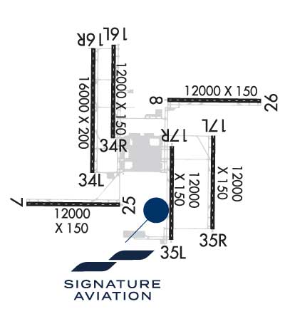
| |||||||||||||||||||||||||||||||||||||||||||||||||||||||||||||||||||||
| |||||||||||||||||||||||||||||||||||||||||||||||||||||||||||||||||||||
| |||||||||||||||||||||||||||||||||||||||||||||||||||||||||||||||||||||
| |||||||||||||||||||||||||||||||||||||||||||||||||||||||||||||||||||||
| Rwy | Rwy | |||||||
| 12000x150 | 12000' | 111.55 - 082° | 12000x150 | 12000' | 111.55 - 262° | |||
| 12000x150 | 12000' | 108.90 - 082° | 12000x150 | 12000' | 108.90 - 262° | |||
| 12000x150 | 12000' | 111.10 - 172° | 12000x150 | 12000' | 111.10 - 352° | |||
| 16000x200 | 16000' | 111.90 - 172° | 16000x200 | 16000' | 111.90 - 352° | |||
| 12000x150 | 12000' | 110.15 - 172° | 12000x150 | 12000' | 110.15 - 352° | |||
| 12000x150 | 12000' | 108.50 - 172° | 12000x150 | 12000' | 108.50 - 352° | |||
| Runway ID | Single Wheel | Double Wheel | Double Tandem Wheel | Dual Double Wheel |
| 07/25 | 116,000 | 240,000 | 515,000 | 1,085,000 |
| 08/26 | 116,000 | 240,000 | 515,000 | 1,085,000 |
| 16L/34R | 116,000 | 240,000 | 515,000 | 1,085,000 |
| 16R/34L | 116,000 | 240,000 | 515,000 | 1,085,000 |
| 17L/35R | 116,000 | 240,000 | 515,000 | 1,085,000 |
| 17R/35L | 116,000 | 240,000 | 515,000 | 1,085,000 |
| These numbers are Advisory and are not limits. The Airport Manager should have more accurate Weight Limits | ||||
 Airport Diagram might not be current. | |
| Facility Name: | DENVER INTL |
| City Name: | DENVER |
| County: | DENVER |
| State abbrev: | CO |
| State Name: | COLORADO |
| Ownership: | PUBLICLY OWNED |
| Use: | OPEN TO THE PUBLIC |
| Owner's Name: | CITY & COUNTY OF DENVER |
| Address: | DEPT OF AVIATION |
| DENVER, CO 80249 | |
| Owner's Phone: | 303-342-2200 |
| Manager's Name: | KIM DAY |
| Address: | ADMIN BLDG, 8500 PENA BLVD |
| DENVER, CO 80249 | |
| Phone: | (303) 342-2206 |
| FAA Region: | NORTHWEST MOUNTAIN |
| FAA Field Office: | DEN |
| Date | Sunrise | Sunset |
|---|---|---|
| 09/24/21 Friday | 6:48 | 18:53 |
| 09/25/21 Saturday | 6:49 | 18:51 |
| 09/26/21 Sunday | 6:50 | 18:49 |
| 09/27/21 Monday | 6:51 | 18:48 |
| 09/28/21 Tuesday | 6:52 | 18:46 |
| 09/29/21 Wednesday | 6:53 | 18:45 |
| 09/30/21 Thursday | 6:54 | 18:43 |
| 10/01/21 Friday | 6:55 | 18:41 |
| 10/02/21 Saturday | 6:56 | 18:40 |
| 10/03/21 Sunday | 6:57 | 18:38 |
| 10/04/21 Monday | 6:58 | 18:37 |
| 10/05/21 Tuesday | 6:59 | 18:35 |
| 10/06/21 Wednesday | 7:00 | 18:33 |
| 10/07/21 Thursday | 7:01 | 18:32 |
| Airport Attendance Schedule | CONTINUOUS |
| Airport Status | OPERATIONAL (This Status can change at any time - please check NOTAMS) |
| Airport Lighting Schedule | SS-SR |
| Airport Storage Available | Hanger |
| Extra Services Available | NONE |
| Wind Indicator | YES - (unlit) |
| Control Tower | YES |
| CTAF Frequency | |
| Unicom Frequency | 122.950 |
| Rotating Beacon Color | CLEAR-GREEN (Light Land Airport) |
| Segmented Circle | NO |
| Landing Fee | YES |
| Airport Inspected | FEDERAL - performed by FAA AIRPORTS FIELD PERSONNEL |
| Inspection Date | 09/17/2019 |
| Type of Fuel Available | Grade 100LL, JET A (freeze point -40C) |
| Airframe Repair Service | MAJOR |
| Power Plant Repair Service | MAJOR |
| Latitude | N3951.7 |
| Longitude | W10440.4 (ESTIMATED) |
| Arpt Elevation | 5433ft (SURVEYED) |
| Magnetic Variation | 08E |
| 16 miles NE | of DENVER |
| Traffic Pattern Altitude | |
| Sectional Chart | DENVER |
| Operations (Reported) | Yearly | Avg. Daily |
|---|---|---|
| General Aviation Transient | 0 | 0 |
| General Aviation Local | 3979 | 11 |
| Air Taxi | 137027 | 375 |
| Commerical | 462276 | 1267 |
| Commuter | 0 | 0 |
| Military | 121 | 0 |
| Aircraft based on Field | |
|---|---|
| General Aviation Singles | 0 |
| General Aviation Multi | 1 |
| Jet Aircraft | 0 |
| General Aviation Helicopters | 0 |
| Military Aircraft | 0 |
| Gliders | 0 |
| Ultralights | 0 |
| FSS on field | NO |
| FSS tie-in | DENVER |
| FSS Phone | 1-800-WX-BRIEF |
| Who issues Notams | DEN |
| Notam D service at airport | YES |
| ARTCC Name | DENVER |
| Airport Certification | AIRPORT RECEIVING SCHEDULED AIR CARRIER SERVICE FROM CARRIERS CERTIFICATED BY THE CIVIL AERONAUTICS BOARD |
| Aircraft Rescue & Firefighting Index | AIRPORT HAS A CERTIFICATE UNDER CFR PART 139 |
| Airport of Entry | No |
| Custom Landing Rights | No |
| Joint Civil/Military | No |
| Military Landing rights | No |
| NATIONAL PLAN OF INTEGRATED AIRPORT SYSTEMS (NPIAS) |
| GRANT AGREEMENTS UNDER FAAP/ADAP/AIP |
| ASSURANCES PURSUANT TO TITLE VI, CIVIL RIGHTS ACT OF 1964 |
| ARPT MAINTAINS CLEARWAYS (500 FT X 1,000 FT, 1.25% SLOPE) ON DEP RY 08, RY 25, & RY 34R. |
| ASDE-X IN USE. OPERATE TRANSPONDERS WITH ALTITUDE REPORTING MODE AND ADS-B (IF EQUIPPED) ENABLED ON ALL AIRPORT SURFACES. |
| TWY F7 CLSD TO ACFT WINGSPAN MORE THAN 118 FT. |
| OVERHEAD PSGR BRIDGE ON SOUTH SIDE OF CONCOURSE 'A' PRVDS 42 FT TAIL & 118 FT WINGSPAN CLNC WHEN ON TWY CNTRLN. |
| CUSTOMS AVBL WITH PRIOR PERMISSION. |
| INFORMAL RY USE PROGRAM IS IN EFFECT 24 HRS A DAY. FOR ADDITIONAL NOISE ABATEMENT INFORMATION CONTACT AIRPORT MANAGEMENT AT 303-342-4200. |
| WATERFOWL AND MIGRATORY BIRD ACTIVITY INVOF ARPT YEAR ROUND. |
Airport Communications & Frequencies:
| |||||||||||||||||||||||||||||||||||||||||||||||||||||||||||||||||||||||||||||||||||||||
| Runway: 07 | Runway: 25 | ||
| Mag heading: | 82° | Mag heading: | 263° |
| Rwy Slope: | .04% Up | Rwy Slope: | -.04% Down |
| Approach: | ILS/DME | Approach: | ILS/DME |
| Pattern: | Left Traffic | Pattern: | Left Traffic |
| Markings: | PRECISION INSTRUMENT | Markings: | PRECISION INSTRUMENT |
| Marking Condition: | GOOD | Marking Condition: | GOOD |
| Arresting Dev: | Arresting Dev: | ||
| Lat & Long: | N3950.5 W10443.6 | Lat. & Long.: | N3950.4 W10441.0 |
| Elev: | 5350.2 ft. MSL | Elev: | 5355.0 ft. MSL |
| TCH: | 68 ft. AGL | TCH: | 83 ft. AGL |
| Visual Glide Path: | 3.00 degrees | Visual Glide Path: | 3.00 degrees |
| Displaced Threshold: | No | Displaced Threshold: | No |
| Touchdown Zone: | YES | Touchdown Zone: | YES |
| Touchdown Elev.: | 5351.6 feet | Touchdown Elev.: | 5355.0 feet |
| Visual Glide Slope: | 4-Light PAPI on RIGHT side of Runway | Visual Glide Slope: | 4-Light PAPI on LEFT side of Runway |
| RVR Equipment: | TOUCHDOWN-ROLLOUT | RVR Equipment: | TOUCHDOWN-ROLLOUT |
| RVV Equipment: | YES | RVV Equipment: | YES |
| Approach Lights: | MALSR - 1,400 foot medium intensity approach lighting system with runway alignment indicator lights | Approach Lights: | MALSR - 1,400 foot medium intensity approach lighting system with runway alignment indicator lights |
| REIL: | NO | REIL: | NO |
| Centerline Lights: | YES | Centerline Lights: | YES |
| Touchdown lights: | YES | Touchdown lights: | NO |
| Runway Category: | Precision Instrument Runway | Runway Category: | Precision Instrument Runway |
| Declared Distances: | TORA:12000' TODA:12000' ASDA:12000' LDA:12000' | Declared Distances: | TORA:12000' TODA:13000' ASDA:12000' LDA:12000' |
| Runway: 08 | Runway: 26 | ||
| Mag heading: | 83° | Mag heading: | 263° |
| Rwy Slope: | -.50% Down | Rwy Slope: | .50% Up |
| Approach: | ILS/DME | Approach: | ILS/DME |
| Pattern: | Left Traffic | Pattern: | Left Traffic |
| Markings: | PRECISION INSTRUMENT | Markings: | PRECISION INSTRUMENT |
| Marking Condition: | GOOD | Marking Condition: | GOOD |
| Arresting Dev: | Arresting Dev: | ||
| Lat & Long: | N3952.7 W10439.7 | Lat. & Long.: | N3952.6 W10437.2 |
| Elev: | 5354.3 ft. MSL | Elev: | 5294.4 ft. MSL |
| TCH: | 70 ft. AGL | TCH: | 70 ft. AGL |
| Visual Glide Path: | 3.00 degrees | Visual Glide Path: | 3.00 degrees |
| Displaced Threshold: | No | Displaced Threshold: | No |
| Touchdown Zone: | YES | Touchdown Zone: | YES |
| Touchdown Elev.: | 5354.3 feet | Touchdown Elev.: | 5309.4 feet |
| Visual Glide Slope: | 4-Light PAPI on LEFT side of Runway | Visual Glide Slope: | 4-Light PAPI on LEFT side of Runway |
| RVR Equipment: | TOUCHDOWN-ROLLOUT | RVR Equipment: | TOUCHDOWN-ROLLOUT |
| RVV Equipment: | YES | RVV Equipment: | YES |
| Approach Lights: | MALSR - 1,400 foot medium intensity approach lighting system with runway alignment indicator lights | Approach Lights: | MALSR - 1,400 foot medium intensity approach lighting system with runway alignment indicator lights |
| REIL: | NO | REIL: | NO |
| Centerline Lights: | YES | Centerline Lights: | YES |
| Touchdown lights: | NO | Touchdown lights: | YES |
| Runway Category: | Precision Instrument Runway | Runway Category: | Precision Instrument Runway |
| Declared Distances: | TORA:12000' TODA:13000' ASDA:12000' LDA:12000' | Declared Distances: | TORA:12000' TODA:12000' ASDA:12000' LDA:12000' |
| Runway: 16L | Runway: 34R | ||
| Mag heading: | 173° | Mag heading: | 353° |
| Rwy Slope: | .03% Up | Rwy Slope: | -.03% Down |
| Approach: | ILS/DME | Approach: | ILS/DME |
| Pattern: | Left Traffic | Pattern: | Left Traffic |
| Markings: | PRECISION INSTRUMENT | Markings: | PRECISION INSTRUMENT |
| Marking Condition: | GOOD | Marking Condition: | GOOD |
| Arresting Dev: | Arresting Dev: | ||
| Lat & Long: | N3953.8 W10441.2 | Lat. & Long.: | N3951.8 W10441.2 |
| Elev: | 5349.9 ft. MSL | Elev: | 5353.7 ft. MSL |
| TCH: | 71 ft. AGL | TCH: | 63 ft. AGL |
| Visual Glide Path: | 3.00 degrees | Visual Glide Path: | 3.00 degrees |
| Displaced Threshold: | No | Displaced Threshold: | No |
| Touchdown Zone: | YES | Touchdown Zone: | YES |
| Touchdown Elev.: | 5357.1 feet | Touchdown Elev.: | 5353.7 feet |
| Visual Glide Slope: | 4-Light PAPI on LEFT side of Runway | Visual Glide Slope: | 4-Light PAPI on LEFT side of Runway |
| RVR Equipment: | TOUCHDOWN-MIDFIELD-ROLLOUT | RVR Equipment: | TOUCHDOWN-MIDFIELD-ROLLOUT |
| RVV Equipment: | YES | RVV Equipment: | YES |
| Approach Lights: | MALSR - 1,400 foot medium intensity approach lighting system with runway alignment indicator lights | Approach Lights: | ALSF2 - standard 2,400 foot high intensity approach lighting system with sequenced flashers, Category II or III |
| REIL: | NO | REIL: | NO |
| Centerline Lights: | YES | Centerline Lights: | YES |
| Touchdown lights: | YES | Touchdown lights: | YES |
| Runway Category: | Precision Instrument Runway | Runway Category: | Precision Instrument Runway |
| Declared Distances: | TORA:12000' TODA:12000' ASDA:12000' LDA:12000' | Declared Distances: | TORA:12000' TODA:13000' ASDA:12000' LDA:12000' |
| Runway: 16R | Runway: 34L | ||
| Mag heading: | 173° | Mag heading: | 353° |
| Rwy Slope: | .03% Up | Rwy Slope: | -.03% Down |
| Approach: | ILS/DME | Approach: | ILS/DME |
| Pattern: | Left Traffic | Pattern: | Left Traffic |
| Markings: | PRECISION INSTRUMENT | Markings: | PRECISION INSTRUMENT |
| Marking Condition: | GOOD | Marking Condition: | GOOD |
| Arresting Dev: | Arresting Dev: | ||
| Lat & Long: | N3953.7 W10441.8 | Lat. & Long.: | N3951.1 W10441.8 |
| Elev: | 5321.8 ft. MSL | Elev: | 5327.0 ft. MSL |
| TCH: | 71 ft. AGL | TCH: | 70 ft. AGL |
| Visual Glide Path: | 3.00 degrees | Visual Glide Path: | 3.00 degrees |
| Displaced Threshold: | No | Displaced Threshold: | No |
| Touchdown Zone: | YES | Touchdown Zone: | YES |
| Touchdown Elev.: | 5326.3 feet | Touchdown Elev.: | 5327.0 feet |
| Visual Glide Slope: | 4-Light PAPI on RIGHT side of Runway | Visual Glide Slope: | 4-Light PAPI on LEFT side of Runway |
| RVR Equipment: | TOUCHDOWN-MIDFIELD-ROLLOUT | RVR Equipment: | TOUCHDOWN-MIDFIELD-ROLLOUT |
| RVV Equipment: | YES | RVV Equipment: | YES |
| Approach Lights: | MALSR - 1,400 foot medium intensity approach lighting system with runway alignment indicator lights | Approach Lights: | ALSF2 - standard 2,400 foot high intensity approach lighting system with sequenced flashers, Category II or III |
| REIL: | NO | REIL: | NO |
| Centerline Lights: | YES | Centerline Lights: | YES |
| Touchdown lights: | YES | Touchdown lights: | YES |
| Runway Category: | Precision Instrument Runway | Runway Category: | Precision Instrument Runway |
| Declared Distances: | TORA:16000' TODA:16000' ASDA:16000' LDA:16000' | Declared Distances: | TORA:16000' TODA:16000' ASDA:16000' LDA:16000' |
| Runway: 17L | Runway: 35R | ||
| Mag heading: | 173° | Mag heading: | 353° |
| Rwy Slope: | .35% Up | Rwy Slope: | -.35% Down |
| Approach: | ILS/DME | Approach: | ILS/DME |
| Pattern: | Left Traffic | Pattern: | Left Traffic |
| Markings: | PRECISION INSTRUMENT | Markings: | PRECISION INSTRUMENT |
| Marking Condition: | GOOD | Marking Condition: | GOOD |
| Arresting Dev: | Arresting Dev: | ||
| Lat & Long: | N3951.9 W10438.5 | Lat. & Long.: | N3949.9 W10438.5 |
| Elev: | 5328.1 ft. MSL | Elev: | 5370.0 ft. MSL |
| TCH: | 66 ft. AGL | TCH: | 66 ft. AGL |
| Visual Glide Path: | 3.00 degrees | Visual Glide Path: | 3.00 degrees |
| Displaced Threshold: | No | Displaced Threshold: | No |
| Touchdown Zone: | YES | Touchdown Zone: | YES |
| Touchdown Elev.: | 5338.5 feet | Touchdown Elev.: | 5370.0 feet |
| Visual Glide Slope: | 4-Light PAPI on LEFT side of Runway | Visual Glide Slope: | 4-Light PAPI on RIGHT side of Runway |
| RVR Equipment: | TOUCHDOWN-MIDFIELD-ROLLOUT | RVR Equipment: | TOUCHDOWN-MIDFIELD-ROLLOUT |
| RVV Equipment: | YES | RVV Equipment: | YES |
| Approach Lights: | MALSR - 1,400 foot medium intensity approach lighting system with runway alignment indicator lights | Approach Lights: | ALSF2 - standard 2,400 foot high intensity approach lighting system with sequenced flashers, Category II or III |
| REIL: | NO | REIL: | NO |
| Centerline Lights: | YES | Centerline Lights: | YES |
| Touchdown lights: | NO | Touchdown lights: | YES |
| Runway Category: | Precision Instrument Runway | Runway Category: | Precision Instrument Runway |
| Declared Distances: | TORA:12000' TODA:12000' ASDA:12000' LDA:12000' | Declared Distances: | TORA:12000' TODA:12000' ASDA:12000' LDA:12000' |
| Runway: 17R | Runway: 35L | ||
| Mag heading: | 173° | Mag heading: | 353° |
| Rwy Slope: | .47% Up | Rwy Slope: | -.47% Down |
| Approach: | ILS/DME | Approach: | ILS/DME |
| Pattern: | Left Traffic | Pattern: | Left Traffic |
| Markings: | PRECISION INSTRUMENT | Markings: | PRECISION INSTRUMENT |
| Marking Condition: | GOOD | Marking Condition: | GOOD |
| Arresting Dev: | Arresting Dev: | ||
| Lat & Long: | N3951.7 W10439.6 | Lat. & Long.: | N3949.7 W10439.6 |
| Elev: | 5377.9 ft. MSL | Elev: | 5433.8 ft. MSL |
| TCH: | 69 ft. AGL | TCH: | 71 ft. AGL |
| Visual Glide Path: | 3.00 degrees | Visual Glide Path: | 3.00 degrees |
| Displaced Threshold: | No | Displaced Threshold: | No |
| Touchdown Zone: | YES | Touchdown Zone: | YES |
| Touchdown Elev.: | 5391.9 feet | Touchdown Elev.: | 5433.8 feet |
| Visual Glide Slope: | 4-Light PAPI on LEFT side of Runway | Visual Glide Slope: | 4-Light PAPI on RIGHT side of Runway |
| RVR Equipment: | TOUCHDOWN-MIDFIELD-ROLLOUT | RVR Equipment: | TOUCHDOWN-MIDFIELD-ROLLOUT |
| RVV Equipment: | YES | RVV Equipment: | YES |
| Approach Lights: | MALSR - 1,400 foot medium intensity approach lighting system with runway alignment indicator lights | Approach Lights: | ALSF2 - standard 2,400 foot high intensity approach lighting system with sequenced flashers, Category II or III |
| REIL: | NO | REIL: | NO |
| Centerline Lights: | YES | Centerline Lights: | YES |
| Touchdown lights: | YES | Touchdown lights: | YES |
| Runway Category: | Precision Instrument Runway | Runway Category: | Precision Instrument Runway |
| Declared Distances: | TORA:12000' TODA:12000' ASDA:12000' LDA:12000' | Declared Distances: | TORA:12000' TODA:12000' ASDA:12000' LDA:12000' |
Thanks for using FltPlan.com
all rights reserved © 1999-2021 by Flight Plan LLC


