
| PAPPY BOYINGTON FIELD COEUR D'ALENE ID |
| |
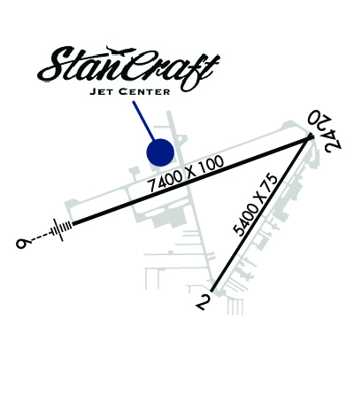
| Lat: N 4746.5 Long: W 11649.2 Elev: 2320 Var: -19 Longest Runway: 7400 | ||
| AWOS: 135.07 CTAF: 122.8 | ||
| ||||||||||||||||||||||||||||||||||||||||||||||||||||||||||||||||||||
| ||||||||||||||||||||||||||||||||||||||||||||||||||||||||||||||||||||
| ||||||||||||||||||||||||||||||||||||||||||||||||||||||||||||||||||||
| ||||||||||||||||||||||||||||||||||||||||||||||||||||||||||||||||||||
| Rwy | Rwy | |||||||
| 5400x75 | 5400' | 5400x75 | 5400' | |||||
| 7400x100 | 7400' | 110.70 - 051° | 7400x100 | 7400' | ||||
| Runway ID | Single Wheel | Double Wheel | Double Tandem Wheel | Dual Double Wheel |
| 02/20 | 50,000 | 83,000 | 150,000 | N/A |
| 06/24 | 57,000 | 95,000 | 165,000 | N/A |
| These numbers are Advisory and are not limits. The Airport Manager should have more accurate Weight Limits | ||||
 Airport Diagram might not be current. | |
| Facility Name: | COEUR D'ALENE/PAPPY BOYINGTON FLD |
| City Name: | COEUR D'ALENE |
| County: | KOOTENAI |
| State abbrev: | ID |
| State Name: | IDAHO |
| Ownership: | PUBLICLY OWNED |
| Use: | OPEN TO THE PUBLIC |
| Owner's Name: | KOOTENAI COUNTY |
| Address: | PO BOX 9000 |
| COEUR D ALENE, ID 83816 | |
| Owner's Phone: | 208-446-1600 |
| Manager's Name: | GASTON PATTERSON |
| Address: | 10375 SENSOR AVE |
| HAYDEN, ID 83835 | |
| Phone: | 208-446-1860 |
| FAA Region: | NORTHWEST MOUNTAIN |
| FAA Field Office: | HLN |
| Date | Sunrise | Sunset |
|---|---|---|
| 12/20/25 Saturday | 7:33 | 15:57 |
| 12/21/25 Sunday | 7:33 | 15:57 |
| 12/22/25 Monday | 7:34 | 15:58 |
| 12/23/25 Tuesday | 7:34 | 15:59 |
| 12/24/25 Wednesday | 7:35 | 15:59 |
| 12/25/25 Thursday | 7:35 | 16:00 |
| 12/26/25 Friday | 7:35 | 16:01 |
| 12/27/25 Saturday | 7:36 | 16:01 |
| 12/28/25 Sunday | 7:36 | 16:02 |
| 12/29/25 Monday | 7:36 | 16:03 |
| 12/30/25 Tuesday | 7:36 | 16:04 |
| 12/31/25 Wednesday | 7:36 | 16:05 |
| 01/01/26 Thursday | 7:36 | 16:06 |
| 01/02/26 Friday | 7:36 | 16:07 |
| Airport Attendance Schedule | 7 Days A Week 0700-1700 |
| Airport Status | OPERATIONAL (This Status can change at any time - please check NOTAMS) |
| Airport Lighting Schedule | ACTVT MIRL RWY 02/20, HIRL RWY 06/24, REIL RWYS 02 & 24, & MALSR RWY 06 - CTAF. PAPI RWYS 02, 20, 06, & 24 OPER CONTINUOUSLY. |
| Airport Storage Available | Tie Downs, Hanger |
| Extra Services Available | Air Ambulance, Avionics, Charter, Flight Instruction, Aircraft Rental, Aircraft Sales |
| Wind Indicator | YES - (lighted) |
| Control Tower | NO |
| CTAF Frequency | 122.800 |
| Unicom Frequency | 122.800 |
| Rotating Beacon Color | WG |
| Segmented Circle | YES |
| Landing Fee | NO |
| Airport Inspected | FEDERAL - performed by FAA AIRPORTS FIELD PERSONNEL |
| Inspection Date | 05/07/2025 |
| Type of Fuel Available | Grade 100, JET A (freeze point -40C); -10AFT HRS FUEL. SELF SVC AVBL WITH CREDIT CARD. |
| Airframe Repair Service | MAJOR |
| Power Plant Repair Service | MAJOR |
| Latitude | N4746.5 |
| Longitude | W11649.2 (ESTIMATED) |
| Arpt Elevation | 2320ft (SURVEYED) |
| Magnetic Variation | 19E |
| 9 miles NW | of COEUR D'ALENE |
| Traffic Pattern Altitude | |
| Sectional Chart | GREAT FALLS |
| Operations (Reported) | Yearly | Avg. Daily |
|---|---|---|
| General Aviation Transient | 0 | 0 |
| General Aviation Local | 0 | 0 |
| Air Taxi | 0 | 0 |
| Commerical | 0 | 0 |
| Commuter | 0 | 0 |
| Military | 0 | 0 |
| Aircraft based on Field | |
|---|---|
| General Aviation Singles | 0 |
| General Aviation Multi | 0 |
| Jet Aircraft | 0 |
| General Aviation Helicopters | 0 |
| Military Aircraft | 0 |
| Gliders | 0 |
| Ultralights | 0 |
| FSS on field | NO |
| FSS tie-in | BOISE |
| FSS Phone | 1-800-WX-BRIEF |
| Who issues Notams | COE |
| Notam D service at airport | YES |
| ARTCC Name | SEATTLE |
| Airport Certification | 48 HR PPR FOR UNSKED OPNS WITH MORE THAN 30 PSGR SEATS CALL AMGR 208-446-1860. |
| Aircraft Rescue & Firefighting Index | AIRPORT HAS A CERTIFICATE UNDER CFR PART 139 |
| Airport of Entry | No |
| Custom Landing Rights | No; US CUSTOMS USER FEE ARPT. |
| Joint Civil/Military | No |
| Military Landing rights | YES |
| NATIONAL PLAN OF INTEGRATED AIRPORT SYSTEMS (NPIAS) |
| GRANT AGREEMENTS UNDER FAAP/ADAP/AIP |
| ASSURANCES PURSUANT TO TITLE VI, CIVIL RIGHTS ACT OF 1964 |
| AGREEMENT UNDER DLAND OR DCLA HAS EXPIRED. |
| MIGRATORY BIRDS ON & INVOF ARPT OCT-NOV. |
| RWY: CONDS NOT MNTD 5 PM TO 7 AM DLY. |
| FOR CD IF UNA CTC ON 132.1 CTC SPOKANE APCH AT 509-742-2522. |
| PJE IN VCNTY. |
| RWY 02/2 0 PCR VALUE: 600/F/B/X/T |
| RWY 06/2 4 PCR VALUE: 470/F/A/X/T |
Airport Communications & Frequencies:
| ||||||||||||||
| Runway: 02 | Runway: 20 | ||
| Mag heading: | 13° | Mag heading: | 193° |
| Rwy Slope: | .25% Up | Rwy Slope: | -.25% Down |
| Approach: | Approach: | ||
| Pattern: | Right Traffic | Pattern: | Left Traffic |
| Markings: | NONPRECISION INSTRUMENT | Markings: | NONPRECISION INSTRUMENT |
| Marking Condition: | GOOD | Marking Condition: | GOOD |
| Arresting Dev: | Arresting Dev: | ||
| Lat & Long: | N4746.0 W11649.3 | Lat. & Long.: | N4746.7 W11648.5 |
| Elev: | 2305.6 ft. MSL | Elev: | 2319.0 ft. MSL |
| TCH: | 36 ft. AGL | TCH: | 37 ft. AGL |
| Visual Glide Path: | 3.00 degrees | Visual Glide Path: | 3.00 degrees |
| Displaced Threshold: | No | Displaced Threshold: | No |
| Touchdown Zone: | YES | Touchdown Zone: | YES |
| Touchdown Elev.: | 2311.0 feet | Touchdown Elev.: | 2319.2 feet |
| Visual Glide Slope: | 2-Light PAPI on LEFT side of Runway | Visual Glide Slope: | 2-Light PAPI on LEFT side of Runway |
| RVR Equipment: | RVR Equipment: | ||
| RVV Equipment: | NO | RVV Equipment: | NO |
| Approach Lights: | Approach Lights: | ||
| REIL: | YES | REIL: | NO |
| Centerline Lights: | NO | Centerline Lights: | NO |
| Touchdown lights: | NO | Touchdown lights: | NO |
| Runway Category: | Runway with a Non-precision Approach | Runway Category: | Runway with a Non-precision Approach |
| Declared Distances: | TORA:5400' TODA:5400' ASDA:5400' LDA:5400' | Declared Distances: | TORA:5400' TODA:5400' ASDA:5400' LDA:5400' |
| Runway: 06 | Runway: 24 | ||
| Mag heading: | 51° | Mag heading: | 231° |
| Rwy Slope: | .58% Up | Rwy Slope: | -.58% Down |
| Approach: | ILS | Approach: | |
| Pattern: | Left Traffic | Pattern: | Left Traffic |
| Markings: | PRECISION INSTRUMENT | Markings: | PRECISION INSTRUMENT |
| Marking Condition: | GOOD | Marking Condition: | GOOD |
| Arresting Dev: | Arresting Dev: | ||
| Lat & Long: | N4746.3 W11650.2 | Lat. & Long.: | N4746.7 W11648.5 |
| Elev: | 2277.4 ft. MSL | Elev: | 2320.3 ft. MSL |
| TCH: | 57 ft. AGL | TCH: | 47 ft. AGL |
| Visual Glide Path: | 3.00 degrees | Visual Glide Path: | 3.00 degrees |
| Displaced Threshold: | No | Displaced Threshold: | No |
| Touchdown Zone: | YES | Touchdown Zone: | YES |
| Touchdown Elev.: | 2290.6 feet | Touchdown Elev.: | 2320.3 feet |
| Visual Glide Slope: | 4-Light PAPI on RIGHT side of Runway | Visual Glide Slope: | 4-Light PAPI on RIGHT side of Runway |
| RVR Equipment: | RVR Equipment: | ||
| RVV Equipment: | NO | RVV Equipment: | NO |
| Approach Lights: | MALSR - 1,400 foot medium intensity approach lighting system with runway alignment indicator lights; RWY 06 NSTD MALSR; THLD BAR EXTENDS 5 FT BYD RWY EDGE LGTS EACH SIDE. | Approach Lights: | |
| REIL: | NO | REIL: | YES |
| Centerline Lights: | NO | Centerline Lights: | NO |
| Touchdown lights: | NO | Touchdown lights: | NO |
| Runway Category: | Precision Instrument Runway | Runway Category: | Runway with a Non-precision Approach having visibility minimums greater than 3/4 mile |
| Declared Distances: | TORA:7400' TODA:7400' ASDA:7400' LDA:7400' | Declared Distances: | TORA:7400' TODA:7400' ASDA:7400' LDA:7400' |
Thanks for using FltPlan.com
all rights reserved © 1999-2025 by Flight Plan LLC


