
| CHANDLER MUNI CHANDLER AZ |
| |
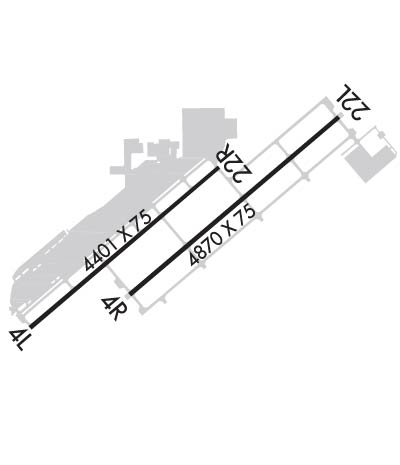
| Lat: N 3316.1 Long: W 11148.7 Elev: 1243 Var: -12 Longest Runway: 4870 | ||
| Dept. ATIS: 128.32 Arr. ATIS: 128.32 AWOS: 128.32 Ground: 124.4 Tower: 133.1/126.1 | ||
| ||||||||||||||||||||||||||||||||||||||||||||
| ||||||||||||||||||||||||||||||||||||||||||||
| ||||||||||||||||||||||||||||||||||||||||||||
| ||||||||||||||||||||||||||||||||||||||||||||
| Rwy | Rwy | |||||||
| 4401x75 | 4401' | 4401x75 | 4401' | |||||
| 4870x75 | 4870' | 4870x75 | 4870' | |||||
| Runway ID | Single Wheel | Double Wheel | Double Tandem Wheel | Dual Double Wheel |
| 04L/22R | 30,000 | N/A | N/A | N/A |
| 04R/22L | 30,000 | N/A | N/A | N/A |
| H1 | N/A | N/A | N/A | N/A |
| These numbers are Advisory and are not limits. The Airport Manager should have more accurate Weight Limits | ||||
 Airport Diagram might not be current. | |
| Facility Name: | CHANDLER MUNI |
| City Name: | CHANDLER |
| County: | MARICOPA |
| State abbrev: | AZ |
| State Name: | ARIZONA |
| Ownership: | PUBLICLY OWNED |
| Use: | OPEN TO THE PUBLIC |
| Owner's Name: | CITY OF CHANDLER |
| Address: | 175 S. ARIZONA AVE |
| CHANDLER, AZ 85225 | |
| Owner's Phone: | 480-782-2200 |
| Manager's Name: | STEVEN TURNER; ASSISTANT CITY MANAGER |
| Address: | CHANDLER MUNICIPAL AIRPORT, MS 802, PO BOX 4008; AIRPORT PHYSICAL ADDRESS: 2380 SOUTH STINSON WAY CHANDLER, AZ 85286 |
| CHANDLER, AZ 85244 | |
| Phone: | 480-782-2227 |
| FAA Region: | WESTERN-PACIFIC |
| FAA Field Office: | PHX |
| Date | Sunrise | Sunset |
|---|---|---|
| 09/24/21 Friday | 6:17 | 18:21 |
| 09/25/21 Saturday | 6:17 | 18:20 |
| 09/26/21 Sunday | 6:18 | 18:19 |
| 09/27/21 Monday | 6:19 | 18:17 |
| 09/28/21 Tuesday | 6:19 | 18:16 |
| 09/29/21 Wednesday | 6:20 | 18:15 |
| 09/30/21 Thursday | 6:21 | 18:13 |
| 10/01/21 Friday | 6:21 | 18:12 |
| 10/02/21 Saturday | 6:22 | 18:11 |
| 10/03/21 Sunday | 6:23 | 18:09 |
| 10/04/21 Monday | 6:23 | 18:08 |
| 10/05/21 Tuesday | 6:24 | 18:07 |
| 10/06/21 Wednesday | 6:25 | 18:05 |
| 10/07/21 Thursday | 6:26 | 18:04 |
| Airport Attendance Schedule | MON-FRI 0500-1700, SAT-SUN 0500-1530 |
| Airport Status | OPERATIONAL (This Status can change at any time - please check NOTAMS) |
| Airport Lighting Schedule | WHEN ATCT CLSD ACTVT REIL RWY 04R & 22L; PAPI RWY 04R & 22L AND RWY 04L & 22R; MIRL RWY 04R/22L & 04L/22R - CTAF. |
| Airport Storage Available | Tie Downs |
| Extra Services Available | Crop Dusting, Avionics, Charter, Flight Instruction, Aircraft Rental, Aircraft Sales |
| Wind Indicator | YES - (lighted) |
| Control Tower | YES |
| CTAF Frequency | 126.100 |
| Unicom Frequency | 122.950 |
| Rotating Beacon Color | CLEAR-GREEN (Light Land Airport) |
| Segmented Circle | YES |
| Landing Fee | NO |
| Airport Inspected | STATE - performed by PRIVATE CONTRACT PERSONNEL |
| Inspection Date | 04/15/2021 |
| Type of Fuel Available | Grade 100LL, JET A |
| Airframe Repair Service | MAJOR |
| Power Plant Repair Service | MAJOR |
| Latitude | N3316.1 |
| Longitude | W11148.7 (ESTIMATED) |
| Arpt Elevation | 1243ft (SURVEYED) |
| Magnetic Variation | 12E |
| 3 miles SE | of CHANDLER |
| Traffic Pattern Altitude | 1057; FIXED WING - 2300 FT MSL. ROTORWING - 1900 FT MSL. |
| Sectional Chart | PHOENIX |
| Operations (Reported) | Yearly | Avg. Daily |
|---|---|---|
| General Aviation Transient | 88790 | 243 |
| General Aviation Local | 145830 | 400 |
| Air Taxi | 4240 | 12 |
| Commerical | 0 | 0 |
| Commuter | 0 | 0 |
| Military | 440 | 1 |
| Aircraft based on Field | |
|---|---|
| General Aviation Singles | 380 |
| General Aviation Multi | 32 |
| Jet Aircraft | 8 |
| General Aviation Helicopters | 23 |
| Military Aircraft | 0 |
| Gliders | 1 |
| Ultralights | 1 |
| FSS on field | NO |
| FSS tie-in | PRESCOTT |
| FSS Phone | 1-800-WX-BRIEF |
| Who issues Notams | CHD |
| Notam D service at airport | YES |
| ARTCC Name | ALBUQUERQUE |
| Airport Certification | |
| Aircraft Rescue & Firefighting Index | None |
| Airport of Entry | No |
| Custom Landing Rights | No |
| Joint Civil/Military | No |
| Military Landing rights | YES |
| NATIONAL PLAN OF INTEGRATED AIRPORT SYSTEMS (NPIAS) |
| GRANT AGREEMENTS UNDER FAAP/ADAP/AIP |
| ASSURANCES PURSUANT TO TITLE VI, CIVIL RIGHTS ACT OF 1964 |
| THIS AIRPORT HAS BEEN SURVEYED BY THE NATIONAL GEODETIC SURVEY. |
| LARGE BIRDS SOAR ALL YEAR. |
| POWER LINE MONO-POLES RUNNING NORTH TO SOUTH APRXLY 1.5 MILES WEST OF ARPT; HEIGHT 135 FT AGL. LIGHTED. |
| POWER LINE MONO-POLES RUNNING EAST TO WEST APRXLY 1 MI SOUTH OF ARPT; HEIGHT 135 FT AGL. NO OBSTRUCTION LIGHTING ON STRUCTURES. |
| CALM WIND CONDS USE RWY 4L OR 4R. |
| TWY A NOT VISIBLE TO ATCT BTN TWY D & TWY F. |
| PLASI TO H1 IS ALIGNED AT 229 DEGS. |
| TRANSIENT HELICOPTER PARKING ON NORTH SIDE BY TAXIWAY "N" AVAILABLE FOR PARKING OR PASSENGER PICK-UP. |
| SIGNIFICANT FIXED AND ROTOR WING TRAINING ACTIVITY ON AIRPORT. |
| EXTENSIVE HELO OPS ON TWY C. CHARLIE PATTERN FOR HELO TRAINING |
| WHEN ATCT CLSD, FOR CD CTC PHOENIX APPROACH AT 602-306-2565. |
| GA TRANSIENT FIXED WING PARKING BOXES IN FRONT OF TERMINAL. |
| WILDLIFE OCCASIONALLY CROSSING RYS & TWYS. |
| ARPT HAS PARALLEL RWYS WITH STAGGERED APCH ENDS. |
| ANTENNA 85 FT AGL LCTD 1/4 MILE NORTH OF RY 22R. |
| AVOID OVERFLIGHT OF HIGH SCHOOL 2 NM SW OF ARPT. |
| RWY 04R/ 22LRWY 04R/22L HAS 90 FT STOPWAYS AT EACH END |
Airport Communications & Frequencies:
| |||||||||||||||||||||||||||||
| Runway: 04L | Runway: 22R | ||
| Mag heading: | 38° | Mag heading: | 218° |
| Rwy Slope: | .12% Up | Rwy Slope: | -.12% Down |
| Approach: | Approach: | ||
| Pattern: | Left Traffic | Pattern: | Right Traffic |
| Markings: | BASIC | Markings: | BASIC |
| Marking Condition: | FAIR | Marking Condition: | FAIR |
| Arresting Dev: | Arresting Dev: | ||
| Lat & Long: | N3315.8 W11149.2 | Lat. & Long.: | N3316.3 W11148.5 |
| Elev: | 1231.0 ft. MSL | Elev: | 1236.4 ft. MSL |
| TCH: | 48 ft. AGL | TCH: | 40 ft. AGL |
| Visual Glide Path: | 3.50 degrees | Visual Glide Path: | 3.00 degrees |
| Displaced Threshold: | No | Displaced Threshold: | No |
| Touchdown Zone: | YES | Touchdown Zone: | YES |
| Touchdown Elev.: | 1234.5 feet | Touchdown Elev.: | 1236.5 feet |
| Visual Glide Slope: | 4-Light PAPI on LEFT side of Runway | Visual Glide Slope: | 4-Light PAPI on LEFT side of Runway |
| RVR Equipment: | RVR Equipment: | ||
| RVV Equipment: | NO | RVV Equipment: | NO |
| Approach Lights: | Approach Lights: | ||
| REIL: | NO | REIL: | NO |
| Centerline Lights: | NO | Centerline Lights: | NO |
| Touchdown lights: | NO | Touchdown lights: | NO |
| Runway Category: | Runway with a Visual Approach | Runway Category: | Runway with a Visual Approach |
| Declared Distances: | Declared Distances: |
| Runway: 04R | Runway: 22L | ||
| Mag heading: | 38° | Mag heading: | 218° |
| Rwy Slope: | .15% Up | Rwy Slope: | -.15% Down |
| Approach: | Approach: | ||
| Pattern: | Right Traffic | Pattern: | Left Traffic |
| Markings: | NONPRECISION INSTRUMENT | Markings: | NONPRECISION INSTRUMENT |
| Marking Condition: | GOOD | Marking Condition: | FAIR |
| Arresting Dev: | Arresting Dev: | ||
| Lat & Long: | N3315.9 W11148.8 | Lat. & Long.: | N3316.5 W11148.1 |
| Elev: | 1235.9 ft. MSL | Elev: | 1243.3 ft. MSL |
| TCH: | 39 ft. AGL | TCH: | 45 ft. AGL |
| Visual Glide Path: | 3.00 degrees | Visual Glide Path: | 3.00 degrees |
| Displaced Threshold: | No | Displaced Threshold: | No |
| Touchdown Zone: | YES | Touchdown Zone: | YES |
| Touchdown Elev.: | 1239.7 feet | Touchdown Elev.: | 1243.4 feet |
| Visual Glide Slope: | 4-Light PAPI on LEFT side of Runway | Visual Glide Slope: | 4-Light PAPI on LEFT side of Runway |
| RVR Equipment: | RVR Equipment: | ||
| RVV Equipment: | NO | RVV Equipment: | NO |
| Approach Lights: | Approach Lights: | ||
| REIL: | YES | REIL: | YES |
| Centerline Lights: | NO | Centerline Lights: | NO |
| Touchdown lights: | NO | Touchdown lights: | NO |
| Runway Category: | Runway with a Non-precision Approach | Runway Category: | Runway with a Visual Approach |
| Declared Distances: | Declared Distances: |
Thanks for using FltPlan.com
all rights reserved © 1999-2021 by Flight Plan LLC
