
| CUYAHOGA COUNTY CLEVELAND OH |
| |
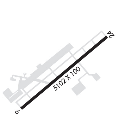
| Lat: N 4133.9 Long: W 08129.2 Elev: 876 Var: +08 Longest Runway: 5502 | ||
| Clr Del: 121.85 TWR CD Dept. ATIS: 119.95 Arr. ATIS: 119.95 Ground: 121.85 Tower: 118.5 | ||
| ||||||||||||||||||||||||||||||||||||||||||||
| ||||||||||||||||||||||||||||||||||||||||||||
| ||||||||||||||||||||||||||||||||||||||||||||
| Rwy | Rwy | |||||||
| 5502x100 | 5184' | 5502x100 | 5002' | 111.10 - 237° | ||||
| Runway ID | Single Wheel | Double Wheel | Double Tandem Wheel | Dual Double Wheel |
| 06/24 | 90,000 | 123,000 | 213,000 | N/A |
| These numbers are Advisory and are not limits. The Airport Manager should have more accurate Weight Limits | ||||
 Airport Diagram might not be current. | |
| Facility Name: | CUYAHOGA COUNTY |
| City Name: | CLEVELAND |
| County: | CUYAHOGA |
| State abbrev: | OH |
| State Name: | OHIO |
| Ownership: | PUBLICLY OWNED |
| Use: | OPEN TO THE PUBLIC |
| Owner's Name: | CUYAHOGA COUNTY |
| Address: | 26300 CURTISS WRIGHT PKWY |
| RICHMOND HEIGHTS, OH 44143-4408 | |
| Owner's Phone: | 216-289-4111 |
| Manager's Name: | J MYERS; CCAIRPORT@CUYAHOGACOUNTY.US. |
| Address: | 26300 CURTISS WRIGHT PKWY |
| RICHMOND HEIGHTS, OH 44143-4408 | |
| Phone: | 216-289-4111 |
| FAA Region: | GREAT LAKES |
| FAA Field Office: | DET |
| Date | Sunrise | Sunset |
|---|---|---|
| 02/23/26 Monday | 7:10 | 18:09 |
| 02/24/26 Tuesday | 7:09 | 18:10 |
| 02/25/26 Wednesday | 7:07 | 18:12 |
| 02/26/26 Thursday | 7:06 | 18:13 |
| 02/27/26 Friday | 7:04 | 18:14 |
| 02/28/26 Saturday | 7:03 | 18:15 |
| 03/01/26 Sunday | 7:01 | 18:16 |
| 03/02/26 Monday | 7:00 | 18:18 |
| 03/03/26 Tuesday | 6:58 | 18:19 |
| 03/04/26 Wednesday | 6:56 | 18:20 |
| 03/05/26 Thursday | 6:55 | 18:21 |
| 03/06/26 Friday | 6:53 | 18:22 |
| 03/07/26 Saturday | 6:52 | 18:23 |
| 03/08/26 Sunday | 7:50 | 19:24 |
| Airport Attendance Schedule | 7 Days A Week 0600-2300; FOR AFT HRS SVC CALL 216-261-8800 DRG ATNDD HRS. |
| Airport Status | OPERATIONAL (This Status can change at any time - please check NOTAMS) |
| Airport Lighting Schedule | WHEN ATCT CLSD ACTVT WINDSOCKS; MALSR RWY 24; REIL RWY 06; PAPI RWY 06; HIRL RWY 06/24 - CTAF. PAPI RWY 24 OPR CONSLY. |
| Airport Storage Available | Tie Downs, Hanger |
| Extra Services Available | Air Freight, Avionics, Charter, Flight Instruction, Aircraft Rental, Aircraft Sales |
| Wind Indicator | YES - (lighted) |
| Control Tower | YES |
| CTAF Frequency | 118.500 |
| Unicom Frequency | |
| Rotating Beacon Color | WG |
| Segmented Circle | NO |
| Landing Fee | NO |
| Airport Inspected | FEDERAL - performed by STATE AERONAUTICAL PERSONNEL |
| Inspection Date | 08/13/2024 |
| Type of Fuel Available | Grade 100LL, JET A (freeze point -40C), JET A |
| Airframe Repair Service | MAJOR |
| Power Plant Repair Service | MAJOR |
| Latitude | N4133.9 |
| Longitude | W08129.2 (ESTIMATED) |
| Arpt Elevation | 876ft (SURVEYED) |
| Magnetic Variation | 08W |
| 10 miles E | of CLEVELAND |
| Traffic Pattern Altitude | |
| Sectional Chart | DETROIT |
| Operations (Reported) | Yearly | Avg. Daily |
|---|---|---|
| General Aviation Transient | 0 | 0 |
| General Aviation Local | 0 | 0 |
| Air Taxi | 0 | 0 |
| Commerical | 0 | 0 |
| Commuter | 0 | 0 |
| Military | 0 | 0 |
| Aircraft based on Field | |
|---|---|
| General Aviation Singles | 0 |
| General Aviation Multi | 0 |
| Jet Aircraft | 0 |
| General Aviation Helicopters | 0 |
| Military Aircraft | 0 |
| Gliders | 0 |
| Ultralights | 0 |
| FSS on field | NO |
| FSS tie-in | CLEVELAND |
| FSS Phone | 1-800-WX-BRIEF |
| Who issues Notams | CGF |
| Notam D service at airport | YES |
| ARTCC Name | CLEVELAND |
| Airport Certification | |
| Aircraft Rescue & Firefighting Index | None |
| Airport of Entry | No |
| Custom Landing Rights | No |
| Joint Civil/Military | No |
| Military Landing rights | YES |
| NATIONAL PLAN OF INTEGRATED AIRPORT SYSTEMS (NPIAS) |
| GRANT AGREEMENTS UNDER FAAP/ADAP/AIP |
| ASSURANCES PURSUANT TO TITLE VI, CIVIL RIGHTS ACT OF 1964 |
| NOISE ABATEMENT PROCS IN EFCT CALL ARPT. |
| FOR CD WHEN ATCT CLSD CTC CLEVELAND APCH AT 216-352-2323. |
| BIRDS & WILDLIFE ON & INVOF ARPT. |
| ATCT VIS SW LTD WI 500 FT AER 06. |
| FLT TRG PROHIBITED 2300-0700. |
Airport Communications & Frequencies:
| |||||||||||||||||||||||
| Runway: 06 | Runway: 24 | ||
| Mag heading: | 57° | Mag heading: | 237° |
| Rwy Slope: | -.04% Down | Rwy Slope: | .04% Up |
| Approach: | Approach: | ILS/DME | |
| Pattern: | Left Traffic | Pattern: | Left Traffic |
| Markings: | NONPRECISION INSTRUMENT | Markings: | PRECISION INSTRUMENT |
| Marking Condition: | GOOD | Marking Condition: | GOOD |
| Arresting Dev: | EMAS | Arresting Dev: | EMAS |
| Lat & Long: | N4133.6 W08129.7 | Lat. & Long.: | N4134.2 W08128.8 |
| Elev: | 876.1 ft. MSL | Elev: | 874.0 ft. MSL |
| TCH: | 45 ft. AGL | TCH: | 45 ft. AGL |
| Visual Glide Path: | 3.00 degrees | Visual Glide Path: | 3.00 degrees |
| Displaced Threshold: | 318 feet | Displaced Threshold: | 500 feet |
| Touchdown Zone: | YES | Touchdown Zone: | YES |
| Touchdown Elev.: | 874.2 feet | Touchdown Elev.: | 873.2 feet |
| Visual Glide Slope: | 4-Light PAPI on LEFT side of Runway | Visual Glide Slope: | 4-Light PAPI on LEFT side of Runway |
| RVR Equipment: | RVR Equipment: | ||
| RVV Equipment: | NO | RVV Equipment: | NO |
| Approach Lights: | Approach Lights: | MALSR - 1,400 foot medium intensity approach lighting system with runway alignment indicator lights | |
| REIL: | YES | REIL: | NO |
| Centerline Lights: | NO | Centerline Lights: | NO |
| Touchdown lights: | NO | Touchdown lights: | NO |
| Runway Category: | Runway with a Non-precision Approach having visibility minimums greater than 3/4 mile | Runway Category: | Precision Instrument Runway |
| Declared Distances: | TORA:5502' TODA:5502' ASDA:5502' LDA:5184' | Declared Distances: | TORA:5502' TODA:5502' ASDA:5502' LDA:5000' |
| Obstructions: | TREE; 7 FT ROAD, 703 FT DIST, 325 FT L. | Obstructions: | ROAD |
| Marked: | NOT Marked/Lighted | Marked: | NOT Marked/Lighted |
| Clearance slope: | 18:1; APCH SLP 24:1 TO DTHR 86 FT TREES, 2087 FT DIST, 336 FT R. | Clearance slope: | APCH SLP 50:1 TO DTHR. |
| Obstruction height: | 86 feet AGL | Obstruction height: | 7 feet AGL |
| Dist. from runway: | 1769 feet | Dist. from runway: | 201 feet |
| Centerline offset: | 336 right of centerline | Centerline offset: | 325 feet left of centerline |
| Comments: | Comments: | 7 FT ROAD, 0 FT DIST, 525 FT L; 2 FT FENCE, 0 FT DIST, 500 FT L. |
Thanks for using FltPlan.com
all rights reserved © 1999-2026 by Flight Plan LLC
