
| CAMPBELL GRAYSLAKE IL |
| |
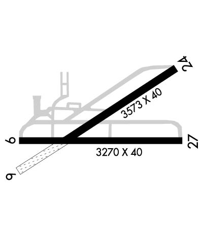
| Lat: N 4219.5 Long: W 08804.4 Elev: 788 Var: +02 Longest Runway: 3573 | ||
| CTAF: 122.7 | ||
| ||||||||||||||||||||||||||||||||||||||||||||
| ||||||||||||||||||||||||||||||||||||||||||||
| Rwy | Rwy | |||||||
| 3573x40 | 3573' | 3573x40 | 3272' | |||||
| 3270x40 | 3270' | 3270x40 | 3270' | |||||
| Runway ID | Single Wheel | Double Wheel | Double Tandem Wheel | Dual Double Wheel |
| 06/24 | N/A | N/A | N/A | N/A |
| 09/27 | N/A | N/A | N/A | N/A |
| These numbers are Advisory and are not limits. The Airport Manager should have more accurate Weight Limits | ||||
 Airport Diagram might not be current. | |
| Facility Name: | CAMPBELL |
| City Name: | GRAYSLAKE |
| County: | LAKE |
| State abbrev: | IL |
| State Name: | ILLINOIS |
| Ownership: | PRIVATELY OWNED |
| Use: | OPEN TO THE PUBLIC |
| Owner's Name: | AIR TECK LLC |
| Address: | 9101 FULLERTON AVE., SUITE 401 |
| FRANKLIN PARK, IL 60131 | |
| Owner's Phone: | 773-240-1650 |
| Manager's Name: | DEAN MOHOMMAD |
| Address: | 22731 W. TOWNLINE ROAD; EMAIL ADDRESS: PJK201@AOL.COM (ALL LOWER CASE) |
| GRAYSLAKE, IL 60030 | |
| Phone: | 773-240-1650 |
| FAA Region: | GREAT LAKES |
| FAA Field Office: | CHI |
| Date | Sunrise | Sunset |
|---|---|---|
| 05/02/26 Saturday | 5:47 | 19:53 |
| 05/03/26 Sunday | 5:45 | 19:54 |
| 05/04/26 Monday | 5:44 | 19:55 |
| 05/05/26 Tuesday | 5:43 | 19:56 |
| 05/06/26 Wednesday | 5:41 | 19:57 |
| 05/07/26 Thursday | 5:40 | 19:58 |
| 05/08/26 Friday | 5:39 | 19:59 |
| 05/09/26 Saturday | 5:38 | 20:00 |
| 05/10/26 Sunday | 5:37 | 20:01 |
| 05/11/26 Monday | 5:35 | 20:02 |
| 05/12/26 Tuesday | 5:34 | 20:04 |
| 05/13/26 Wednesday | 5:33 | 20:05 |
| 05/14/26 Thursday | 5:32 | 20:06 |
| 05/15/26 Friday | 5:31 | 20:07 |
| Airport Attendance Schedule | MON-FRI 0830-1600, SAT-SUN UNATTENDED |
| Airport Status | OPERATIONAL (This Status can change at any time - please check NOTAMS) |
| Airport Lighting Schedule | SS-SR |
| Airport Storage Available | Tie Downs |
| Extra Services Available | NONE |
| Wind Indicator | YES - (lighted) |
| Control Tower | NO |
| CTAF Frequency | 122.700 |
| Unicom Frequency | 122.700 |
| Rotating Beacon Color | WG |
| Segmented Circle | NO |
| Landing Fee | NO |
| Airport Inspected | STATE - performed by STATE AERONAUTICAL PERSONNEL |
| Inspection Date | 10/10/2025 |
| Type of Fuel Available | Grade 100LL |
| Airframe Repair Service | MAJOR |
| Power Plant Repair Service | MAJOR |
| Latitude | N4219.5 |
| Longitude | W08804.4 (ESTIMATED) |
| Arpt Elevation | 788ft (SURVEYED) |
| Magnetic Variation | 02W |
| 2 miles SW | of GRAYSLAKE |
| Traffic Pattern Altitude | 800 |
| Sectional Chart | CHICAGO |
| Operations (Reported) | Yearly | Avg. Daily |
|---|---|---|
| General Aviation Transient | 0 | 0 |
| General Aviation Local | 0 | 0 |
| Air Taxi | 0 | 0 |
| Commerical | 0 | 0 |
| Commuter | 0 | 0 |
| Military | 0 | 0 |
| Aircraft based on Field | |
|---|---|
| General Aviation Singles | 0 |
| General Aviation Multi | 0 |
| Jet Aircraft | 0 |
| General Aviation Helicopters | 0 |
| Military Aircraft | 0 |
| Gliders | 0 |
| Ultralights | 0 |
| FSS on field | NO |
| FSS tie-in | KANKAKEE |
| FSS Phone | 1-800-WX-BRIEF |
| Who issues Notams | IKK |
| Notam D service at airport | YES |
| ARTCC Name | CHICAGO |
| Airport Certification | |
| Aircraft Rescue & Firefighting Index | None |
| Airport of Entry | No |
| Custom Landing Rights | No |
| Joint Civil/Military | No |
| Military Landing rights | No |
| NATIONAL PLAN OF INTEGRATED AIRPORT SYSTEMS (NPIAS) |
| THIS AIRPORT HAS BEEN SURVEYED BY THE NATIONAL GEODETIC SURVEY. |
| NO TOUCH & GO LNDG PERMITTED. |
| UNLGTD POWER LINES 167 FT AGL 3/4 MILE S OF RWY 09/27. |
| NUMEROUS MIGRATORY BIRDS INVOF ARPT. |
| TWYS WITH NSTD SPACING AND CLEARANCES INVOF RAMP APRON. |
| FOR CD CTC CHICAGO APCH AT 847-289-0926. |
| RWY 09/2 7 RWY 09 & 27 NSTD TRIL OTS INDEFLY. |
| RWY 06/2 4 SW 1000 FT TURF-GRVL. |
| RWY 06/2 4 PAVEMENT HAS SEVERAL AREAS OF DEPRESSIONS. RWY EDGES DROP OFF IN EXCESS OF 2 INCHES. |
| RWY 09/2 7 LIRL SPACING & LGT INTST VARIES. |
Airport Communications & Frequencies:
| ||||||||||||||
| Runway: 06 | Runway: 24 | ||
| Mag heading: | 60° | Mag heading: | 240° |
| Rwy Slope: | -.03% Down | Rwy Slope: | .03% Up |
| Approach: | Approach: | ||
| Pattern: | Left Traffic | Pattern: | Left Traffic |
| Markings: | NUMBERS ONLY | Markings: | NUMBERS ONLY |
| Marking Condition: | GOOD | Marking Condition: | GOOD |
| Arresting Dev: | Arresting Dev: | ||
| Lat & Long: | N4219.4 W08804.8 | Lat. & Long.: | N4219.7 W08804.1 |
| Elev: | 779.0 ft. MSL | Elev: | 778.0 ft. MSL |
| TCH: | TCH: | ||
| Visual Glide Path: | Visual Glide Path: | ||
| Displaced Threshold: | No | Displaced Threshold: | 301 feet; RWY 24 NSTD DSPLCD THLD WHITE STRIPE MKGS ONLY. MARKED FOR RY 06 ON SW BEGINNING OF PAVED SURFACE. |
| Touchdown Zone: | YES | Touchdown Zone: | YES |
| Touchdown Elev.: | 779.0 feet | Touchdown Elev.: | 779.0 feet |
| Visual Glide Slope: | Visual Glide Slope: | ||
| RVR Equipment: | RVR Equipment: | ||
| RVV Equipment: | NO | RVV Equipment: | NO |
| Approach Lights: | Approach Lights: | ||
| REIL: | NO | REIL: | NO |
| Centerline Lights: | NO | Centerline Lights: | NO |
| Touchdown lights: | NO | Touchdown lights: | NO |
| Runway Category: | Runway with a Visual Approach | Runway Category: | Runway with a Visual Approach |
| Declared Distances: | Declared Distances: | ||
| Obstructions: | TREES | Obstructions: | TREE |
| Marked: | NOT Marked/Lighted | Marked: | NOT Marked/Lighted |
| Clearance slope: | 15:1 | Clearance slope: | 17:1; APCH RATIO 23:1 AT DSPLCD THR. |
| Obstruction height: | 16 feet AGL | Obstruction height: | 78 feet AGL |
| Dist. from runway: | 253 feet | Dist. from runway: | 1540 feet |
| Centerline offset: | 90 right of centerline | Centerline offset: | 86 feet left of centerline |
| Comments: | Comments: | +15 FT RD ADJ RWY END L & R. |
| Runway: 09 | Runway: 27 | ||
| Mag heading: | 92° | Mag heading: | 272° |
| Rwy Slope: | .34% Up | Rwy Slope: | -.34% Down |
| Approach: | Approach: | ||
| Pattern: | Left Traffic | Pattern: | Left Traffic |
| Markings: | NUMBERS ONLY | Markings: | NUMBERS ONLY |
| Marking Condition: | GOOD | Marking Condition: | GOOD |
| Arresting Dev: | Arresting Dev: | ||
| Lat & Long: | N4219.4 W08804.8 | Lat. & Long.: | N4219.4 W08804.1 |
| Elev: | 777.0 ft. MSL | Elev: | 788.0 ft. MSL |
| TCH: | TCH: | ||
| Visual Glide Path: | 4.00 degrees | Visual Glide Path: | 4.00 degrees |
| Displaced Threshold: | No | Displaced Threshold: | No |
| Touchdown Zone: | YES | Touchdown Zone: | YES |
| Touchdown Elev.: | 788.0 feet | Touchdown Elev.: | 788.0 feet |
| Visual Glide Slope: | TRI-COLOR VASI ON LEFT SIDE OF RUNWAY; NSTD TRIL OPR DUSK-DAWN. | Visual Glide Slope: | TRI-COLOR VASI ON LEFT SIDE OF RUNWAY; NSTD TRIL OPR DUSK-DAWN. |
| RVR Equipment: | RVR Equipment: | ||
| RVV Equipment: | NO | RVV Equipment: | NO |
| Approach Lights: | Approach Lights: | ||
| REIL: | NO | REIL: | NO |
| Centerline Lights: | NO | Centerline Lights: | NO |
| Touchdown lights: | NO | Touchdown lights: | NO |
| Runway Category: | Runway with a Visual Approach | Runway Category: | Runway with a Visual Approach |
| Declared Distances: | Declared Distances: |
Thanks for using FltPlan.com
all rights reserved © 1999-2026 by Flight Plan LLC
