
| MIDDLETON MUNI - MOREY FIELD MIDDLETON WI |
| |
| Lat: N 4306.9 Long: W 08931.9 Elev: 928 Var: +01 Longest Runway: 4001 | ||
| Clr Del: 121.72 (GCO) AWOS: 118.67 CTAF: 123.0 | ||
| ||||||||||||||||||||||||||||||
| ||||||||||||||||||||||||||||||
| ||||||||||||||||||||||||||||||
| Rwy | Rwy | |||||||
| 1780x120 | 1780' | 1780x120 | 1780' | |||||
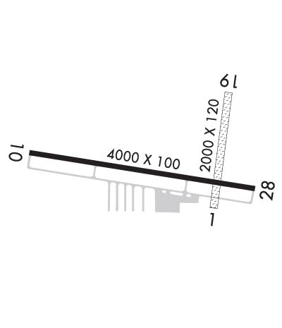
| 4001x100 | 4001' | 110.35 - 100° | 4001x100 | 4001' | ||||
| Runway ID | Single Wheel | Double Wheel | Double Tandem Wheel | Dual Double Wheel |
| 01/19 | N/A | N/A | N/A | N/A |
| 10/28 | N/A | N/A | N/A | N/A |
| These numbers are Advisory and are not limits. The Airport Manager should have more accurate Weight Limits | ||||
 Airport Diagram might not be current. | |
| Facility Name: | MIDDLETON MUNI - MOREY FLD |
| City Name: | MIDDLETON |
| County: | DANE |
| State abbrev: | WI |
| State Name: | WISCONSIN |
| Ownership: | PUBLICLY OWNED |
| Use: | OPEN TO THE PUBLIC |
| Owner's Name: | CITY OF MIDDLETON |
| Address: | 7426 HUBBARD AVENUE |
| MIDDLETON, WI 53562 | |
| Owner's Phone: | 608-827-1050 |
| Manager's Name: | RICHARD MOREY |
| Address: | 8300 AIRPORT ROAD, 7426 HUBBARD AVE; EMAIL ADDRESS: CFIIRICH@TDS.NET (ALL LOWER CASE) |
| MIDDLETON, WI 53562 | |
| Phone: | 608-836-1711 |
| FAA Region: | GREAT LAKES |
| FAA Field Office: | CHI |
| Date | Sunrise | Sunset |
|---|---|---|
| 09/24/21 Friday | 6:47 | 18:52 |
| 09/25/21 Saturday | 6:48 | 18:50 |
| 09/26/21 Sunday | 6:50 | 18:49 |
| 09/27/21 Monday | 6:51 | 18:47 |
| 09/28/21 Tuesday | 6:52 | 18:45 |
| 09/29/21 Wednesday | 6:53 | 18:43 |
| 09/30/21 Thursday | 6:54 | 18:41 |
| 10/01/21 Friday | 6:55 | 18:40 |
| 10/02/21 Saturday | 6:56 | 18:38 |
| 10/03/21 Sunday | 6:57 | 18:36 |
| 10/04/21 Monday | 6:59 | 18:34 |
| 10/05/21 Tuesday | 7:00 | 18:33 |
| 10/06/21 Wednesday | 7:01 | 18:31 |
| 10/07/21 Thursday | 7:02 | 18:29 |
| Airport Attendance Schedule | 7 Days A Week 0800-1730 |
| Airport Status | OPERATIONAL (This Status can change at any time - please check NOTAMS) |
| Airport Lighting Schedule | DUSK-DAWN. ACTVT REIL RWY 10 & 28; MIRL RWY 10/28 - CTAF. |
| Airport Storage Available | Tie Downs, Hanger |
| Extra Services Available | Charter, Flight Instruction, Aircraft Rental |
| Wind Indicator | YES - (lighted) |
| Control Tower | NO |
| CTAF Frequency | 123.000 |
| Unicom Frequency | 123.000 |
| Rotating Beacon Color | CLEAR-GREEN (Light Land Airport) |
| Segmented Circle | NO |
| Landing Fee | NO |
| Airport Inspected | STATE - performed by STATE AERONAUTICAL PERSONNEL |
| Inspection Date | 07/16/2020 |
| Type of Fuel Available | Grade 100LL, JET A (freeze point -40C) |
| Airframe Repair Service | MAJOR |
| Power Plant Repair Service | MAJOR |
| Latitude | N4306.9 |
| Longitude | W08931.9 (ESTIMATED) |
| Arpt Elevation | 928ft (SURVEYED) |
| Magnetic Variation | 01W |
| 5 miles NW | of MIDDLETON |
| Traffic Pattern Altitude | |
| Sectional Chart | CHICAGO |
| Operations (Reported) | Yearly | Avg. Daily |
|---|---|---|
| General Aviation Transient | 13000 | 36 |
| General Aviation Local | 25000 | 68 |
| Air Taxi | 2500 | 7 |
| Commerical | 0 | 0 |
| Commuter | 0 | 0 |
| Military | 10 | 0 |
| Aircraft based on Field | |
|---|---|
| General Aviation Singles | 82 |
| General Aviation Multi | 8 |
| Jet Aircraft | 1 |
| General Aviation Helicopters | 4 |
| Military Aircraft | 0 |
| Gliders | 0 |
| Ultralights | 0 |
| FSS on field | NO |
| FSS tie-in | GREEN BAY |
| FSS Phone | 1-800-WX-BRIEF |
| Who issues Notams | GRB |
| Notam D service at airport | YES |
| ARTCC Name | CHICAGO |
| Airport Certification | |
| Aircraft Rescue & Firefighting Index | None |
| Airport of Entry | No |
| Custom Landing Rights | No |
| Joint Civil/Military | No |
| Military Landing rights | No |
| NATIONAL PLAN OF INTEGRATED AIRPORT SYSTEMS (NPIAS) |
| FOR CD WHEN GCO UNA CTC CHICAGO ARTCC AT 630-856-4562. |
| RWY 01/19 CLSD FM NOV 01 THRU APR 30. |
| BIRDS ON & INVOF ARPT. |
| AVOID NOISE SENSITIVE AREA 1 MI SW; SEE CITY OR MOREY CO WEBSITES FOR DETAILS. |
| GCO AVBL ON FREQ 121.725 THRU FLIGHT SVC AND MADISON APCH CTL. |
Airport Communications & Frequencies:
| |||||||||||||||||
| Runway: 01 | Runway: 19 | ||
| Mag heading: | 8° | Mag heading: | 188° |
| Rwy Slope: | .08% Up | Rwy Slope: | -.08% Down |
| Approach: | Approach: | ||
| Pattern: | Left Traffic | Pattern: | Left Traffic |
| Markings: | NONSTANDARD | Markings: | NONSTANDARD |
| Marking Condition: | FAIR; RWY 01/19 MKD WITH YELLOW CONES. | Marking Condition: | FAIR |
| Arresting Dev: | Arresting Dev: | ||
| Lat & Long: | N4306.8 W08931.7 | Lat. & Long.: | N4307.1 W08931.7 |
| Elev: | 926.1 ft. MSL | Elev: | 927.6 ft. MSL |
| TCH: | TCH: | ||
| Visual Glide Path: | Visual Glide Path: | ||
| Displaced Threshold: | No | Displaced Threshold: | No |
| Touchdown Zone: | YES | Touchdown Zone: | YES |
| Touchdown Elev.: | 927.9 feet | Touchdown Elev.: | 927.9 feet |
| Visual Glide Slope: | Visual Glide Slope: | ||
| RVR Equipment: | RVR Equipment: | ||
| RVV Equipment: | NO | RVV Equipment: | NO |
| Approach Lights: | Approach Lights: | ||
| REIL: | NO | REIL: | NO |
| Centerline Lights: | NO | Centerline Lights: | NO |
| Touchdown lights: | NO | Touchdown lights: | NO |
| Runway Category: | Runway with a Visual Approach | Runway Category: | Runway with a Visual Approach |
| Declared Distances: | Declared Distances: | ||
| Obstructions: | Obstructions: | TREES | |
| Marked: | Marked: | NOT Marked/Lighted | |
| Clearance slope: | 20:1 | Clearance slope: | 18:1 |
| Obstruction height: | Obstruction height: | 85 feet AGL | |
| Dist. from runway: | Dist. from runway: | 1600 feet | |
| Centerline offset: | Centerline offset: | 50 feet left of centerline | |
| Comments: | Comments: |
| Runway: 10 | Runway: 28 | ||
| Mag heading: | 101° | Mag heading: | 281° |
| Rwy Slope: | -.03% Down | Rwy Slope: | .03% Up |
| Approach: | LOC/DME | Approach: | |
| Pattern: | Left Traffic | Pattern: | Left Traffic |
| Markings: | NONPRECISION INSTRUMENT | Markings: | NONPRECISION INSTRUMENT |
| Marking Condition: | GOOD | Marking Condition: | GOOD |
| Arresting Dev: | Arresting Dev: | ||
| Lat & Long: | N4306.9 W08932.4 | Lat. & Long.: | N4306.8 W08931.6 |
| Elev: | 927.9 ft. MSL | Elev: | 926.8 ft. MSL |
| TCH: | 31 ft. AGL | TCH: | 36 ft. AGL |
| Visual Glide Path: | 4.00 degrees | Visual Glide Path: | 4.00 degrees |
| Displaced Threshold: | No | Displaced Threshold: | No |
| Touchdown Zone: | YES | Touchdown Zone: | YES |
| Touchdown Elev.: | 928.0 feet | Touchdown Elev.: | 927.5 feet |
| Visual Glide Slope: | 2-Light PAPI on LEFT side of Runway | Visual Glide Slope: | 2-Light PAPI on LEFT side of Runway |
| RVR Equipment: | RVR Equipment: | ||
| RVV Equipment: | NO | RVV Equipment: | NO |
| Approach Lights: | Approach Lights: | ||
| REIL: | YES | REIL: | YES |
| Centerline Lights: | NO | Centerline Lights: | NO |
| Touchdown lights: | NO | Touchdown lights: | NO |
| Runway Category: | Runway with a Non-precision Approach | Runway Category: | Runway with a Non-precision Approach |
| Declared Distances: | Declared Distances: | ||
| Obstructions: | TREES | Obstructions: | |
| Marked: | NOT Marked/Lighted | Marked: | |
| Clearance slope: | 19:1 | Clearance slope: | 20:1 |
| Obstruction height: | 105 feet AGL | Obstruction height: | |
| Dist. from runway: | 2200 feet | Dist. from runway: | |
| Centerline offset: | 430 right of centerline | Centerline offset: | |
| Comments: | Comments: |
Thanks for using FltPlan.com
all rights reserved © 1999-2021 by Flight Plan LLC


