
| GENERAL EDWARD LAWRENCE LOGAN BOSTON MA |
| |
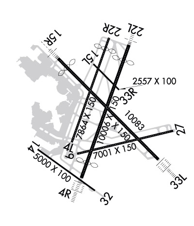
| Lat: N 4221.8 Long: W 07100.4 Elev: 19 Var: +15 Longest Runway: 10083 | ||
| Clr Del: 121.65 Dept. ATIS: 135.0 Arr. ATIS: 135.0 Ground: 121.9/121.75 Tower: 132.22/128.8 | ||
| ||||||||||||||||||||||||||||||||||||||||||||
| ||||||||||||||||||||||||||||||||||||||||||||
| ||||||||||||||||||||||||||||||||||||||||||||
| ||||||||||||||||||||||||||||||||||||||||||||
| Rwy | Rwy | |||||||
| 7864x150 | 7864' | 7864x150 | 7045' | |||||
| 10006x150 | 8851' | 110.30 - 034° | 10006x150 | 8807' | 110.30 - 214° | |||
| 7001x150 | 7001' | 7001x150 | 7001' | 111.30 - 271° | ||||
| 5000x100 | 5000' | 5000x100 | 5000' | |||||
| 2557x100 | 2557' | 2557x100 | 2557' | |||||
| 10083x150 | 9201' | 110.70 - 148° | 10083x150 | 10083' | 110.70 - 331° | |||
| Runway ID | Single Wheel | Double Wheel | Double Tandem Wheel | Dual Double Wheel |
| 04L/22R | 120,000 | 250,000 | 550,000 | N/A |
| 04R/22L | 120,000 | 250,000 | 550,000 | N/A |
| 09/27 | 120,000 | 250,000 | 550,000 | N/A |
| 14/32 | 120,000 | 250,000 | 490,000 | N/A |
| 15L/33R | 120,000 | 250,000 | 550,000 | N/A |
| 15R/33L | 120,000 | 250,000 | 550,000 | N/A |
| These numbers are Advisory and are not limits. The Airport Manager should have more accurate Weight Limits | ||||
 Airport Diagram might not be current. | |
| Facility Name: | GENERAL EDWARD LAWRENCE LOGAN INTL |
| City Name: | BOSTON |
| County: | SUFFOLK |
| State abbrev: | MA |
| State Name: | MASSACHUSETTS |
| Ownership: | PUBLICLY OWNED |
| Use: | OPEN TO THE PUBLIC |
| Owner's Name: | MASS PORT AUTHORITY |
| Address: | ONE HARBORSIDE DR STE 200S |
| BOSTON, MA 02128 | |
| Owner's Phone: | 617-428-2800 |
| Manager's Name: | EDWARD FRENI |
| Address: | LOGAN INTERNATIONAL AIRPORT, HARBORSIDE DR STE 200S |
| EAST BOSTON, MA 02128-2909 | |
| Phone: | 617-567-5400 |
| FAA Region: | NEW ENGLAND |
| FAA Field Office: | NONE |
| Date | Sunrise | Sunset |
|---|---|---|
| 09/24/21 Friday | 6:33 | 18:38 |
| 09/25/21 Saturday | 6:34 | 18:36 |
| 09/26/21 Sunday | 6:35 | 18:35 |
| 09/27/21 Monday | 6:36 | 18:33 |
| 09/28/21 Tuesday | 6:37 | 18:31 |
| 09/29/21 Wednesday | 6:39 | 18:29 |
| 09/30/21 Thursday | 6:40 | 18:28 |
| 10/01/21 Friday | 6:41 | 18:26 |
| 10/02/21 Saturday | 6:42 | 18:24 |
| 10/03/21 Sunday | 6:43 | 18:22 |
| 10/04/21 Monday | 6:44 | 18:21 |
| 10/05/21 Tuesday | 6:45 | 18:19 |
| 10/06/21 Wednesday | 6:46 | 18:17 |
| 10/07/21 Thursday | 6:47 | 18:16 |
| Airport Attendance Schedule | CONTINUOUS |
| Airport Status | OPERATIONAL (This Status can change at any time - please check NOTAMS) |
| Airport Lighting Schedule | |
| Airport Storage Available | NONE |
| Extra Services Available | Air Freight, Cargo Handling, Charter |
| Wind Indicator | YES - (lighted) |
| Control Tower | YES |
| CTAF Frequency | |
| Unicom Frequency | 122.950 |
| Rotating Beacon Color | CLEAR-GREEN (Light Land Airport) |
| Segmented Circle | NO |
| Landing Fee | YES |
| Airport Inspected | FEDERAL - performed by FAA AIRPORTS FIELD PERSONNEL |
| Inspection Date | 09/13/2019 |
| Type of Fuel Available | Grade 100LL, JET A (freeze point -40C) |
| Airframe Repair Service | MAJOR |
| Power Plant Repair Service | MAJOR |
| Latitude | N4221.8 |
| Longitude | W07100.4 (ESTIMATED) |
| Arpt Elevation | 19ft (SURVEYED) |
| Magnetic Variation | 15W |
| 1 miles E | of BOSTON |
| Traffic Pattern Altitude | |
| Sectional Chart | NEW YORK |
| Operations (Reported) | Yearly | Avg. Daily |
|---|---|---|
| General Aviation Transient | 19872 | 54 |
| General Aviation Local | 0 | 0 |
| Air Taxi | 67346 | 185 |
| Commerical | 231418 | 634 |
| Commuter | 0 | 0 |
| Military | 0 | 0 |
| Aircraft based on Field | |
|---|---|
| General Aviation Singles | 0 |
| General Aviation Multi | 0 |
| Jet Aircraft | 0 |
| General Aviation Helicopters | 0 |
| Military Aircraft | 0 |
| Gliders | 0 |
| Ultralights | 0 |
| FSS on field | NO |
| FSS tie-in | BRIDGEPORT |
| FSS Phone | 1-800-WX-BRIEF |
| Who issues Notams | BOS |
| Notam D service at airport | YES |
| ARTCC Name | BOSTON |
| Airport Certification | AIRPORT RECEIVING SCHEDULED AIR CARRIER SERVICE FROM CARRIERS CERTIFICATED BY THE CIVIL AERONAUTICS BOARD |
| Aircraft Rescue & Firefighting Index | AIRPORT HAS A CERTIFICATE UNDER CFR PART 139 |
| Airport of Entry | No |
| Custom Landing Rights | YES |
| Joint Civil/Military | No |
| Military Landing rights | YES |
| NATIONAL PLAN OF INTEGRATED AIRPORT SYSTEMS (NPIAS) |
| GRANT AGREEMENTS UNDER FAAP/ADAP/AIP |
| SURPLUS PROPERTY AGREEMENT UNDER PUBLIC LAW 289 |
| ASSURANCES PURSUANT TO TITLE VI, CIVIL RIGHTS ACT OF 1964 |
| AGREEMENT UNDER DLAND OR DCLA HAS EXPIRED. |
| BIRDS ON & INVOF ARPT. |
| NMRS CRANES ON AND INVOF ARPT. |
| RWY 14/32 UNIDIRECTIONAL; NO LDGS RWY 14; NO TKOFS RWY 32. |
| ASDE-X IN USE. OPERATE TRANSPONDERS WITH ALTITUDE REPORTING MODE AND ADS-B (IF EQUIPPED) ENABLED ON ALL AIRPORT SURFACES. |
| PILOTS SHOULD COMPLETE ALL CALCULATIONS PRIOR TO PUSHBACK FROM GATE. |
| RWY STATUS LGTS IN OPN. |
| NOISE SENSITIVE AREA - HELS OPNG WITHIN THE CTZL ARE REQD TO MAINT THE HIGHEST POSSIBLE ALT. |
| BTN 0000-0600 LCL - RY 15R IS PREFERENTIAL NGT RY FOR TKOF & RY 33L IS PREFERENTIAL NGT RY FOR LNDG. |
| FOR NOISE ABATEMENT PROCEDURES CALL 617-561-1636 0900-1700 MON-FRI. |
| NO RON PARKING FOR NON-TENANT CHARTER AIRCRAFT WITHOUT PRIOR MASSPORT PERMISSION. |
| TERMINAL E; NORTH & SOUTH CARGO ARRIVALS CTC MASSPORT GATE CONTROL ON FREQ 131.1 BEFORE ENTERING/DEPARTING RAMP AREA. |
| RWY 04L/ 22RSEE PCN |
| RWY 04R/ 22LSEE PCN |
| RWY 09/2 7 SEE PCN |
| RWY 14/3 2 SEE PCN |
| RWY 15L/ 33RSEE PCN |
| RWY 15R/ 33LSEE PCN |
Airport Communications & Frequencies:
| |||||||||||||||||||||||||||||||||||||||||||
| Runway: 04L | Runway: 22R | ||
| Mag heading: | 35° | Mag heading: | 215° |
| Rwy Slope: | .01% Up | Rwy Slope: | -.01% Down |
| Approach: | Approach: | ||
| Pattern: | Left Traffic | Pattern: | Left Traffic |
| Markings: | PRECISION INSTRUMENT | Markings: | PRECISION INSTRUMENT |
| Marking Condition: | GOOD | Marking Condition: | GOOD |
| Arresting Dev: | EMAS; ENGINEERING MATERIALS ARRESTING SYSTEM (EMAS) 190 FT IN LENGTH BY 170 FT IN WIDTH LCTD AT DER 04L. | Arresting Dev: | |
| Lat & Long: | N4221.5 W07100.9 | Lat. & Long.: | N4222.7 W07100.3 |
| Elev: | 13.9 ft. MSL | Elev: | 14.9 ft. MSL |
| TCH: | 50 ft. AGL | TCH: | 50 ft. AGL |
| Visual Glide Path: | 3.00 degrees | Visual Glide Path: | 3.00 degrees |
| Displaced Threshold: | No | Displaced Threshold: | 819 feet |
| Touchdown Zone: | YES | Touchdown Zone: | YES |
| Touchdown Elev.: | 13.9 feet | Touchdown Elev.: | 15.2 feet |
| Visual Glide Slope: | 4-Light PAPI on LEFT side of Runway | Visual Glide Slope: | 4-Light PAPI on LEFT side of Runway |
| RVR Equipment: | TOUCHDOWN-ROLLOUT | RVR Equipment: | TOUCHDOWN-ROLLOUT |
| RVV Equipment: | NO | RVV Equipment: | NO |
| Approach Lights: | Approach Lights: | ||
| REIL: | YES | REIL: | NO |
| Centerline Lights: | YES | Centerline Lights: | YES |
| Touchdown lights: | NO | Touchdown lights: | NO |
| Runway Category: | Runway with a Visual Approach | Runway Category: | Runway with a Visual Approach |
| Declared Distances: | TORA:7864' TODA:7864' ASDA:7864' LDA:7864' | Declared Distances: | TORA:7864' TODA:7864' ASDA:7864' LDA:7046' |
| Obstructions: | BOAT | Obstructions: | BOAT |
| Marked: | NOT Marked/Lighted | Marked: | NOT Marked/Lighted |
| Clearance slope: | 18:1 | Clearance slope: | 10:1; APCH RATIO 33:1 FROM DSPLCD THR; 50:1 TO THR WHEN CHANNEL IS CLEAR. |
| Obstruction height: | 161 feet AGL | Obstruction height: | 44 feet AGL |
| Dist. from runway: | 3250 feet | Dist. from runway: | 670 feet |
| Centerline offset: | Centerline offset: | ||
| Comments: | Comments: |
| Runway: 04R | Runway: 22L | ||
| Mag heading: | 35° | Mag heading: | 215° |
| Rwy Slope: | -.04% Down | Rwy Slope: | .04% Up |
| Approach: | ILS/DME | Approach: | ILS/DME |
| Pattern: | Left Traffic | Pattern: | Left Traffic |
| Markings: | PRECISION INSTRUMENT | Markings: | PRECISION INSTRUMENT |
| Marking Condition: | GOOD | Marking Condition: | GOOD |
| Arresting Dev: | Arresting Dev: | ||
| Lat & Long: | N4221.1 W07100.7 | Lat. & Long.: | N4222.6 W07100.0 |
| Elev: | 18.8 ft. MSL | Elev: | 14.5 ft. MSL |
| TCH: | 67 ft. AGL | TCH: | 71 ft. AGL |
| Visual Glide Path: | 3.00 degrees | Visual Glide Path: | 3.00 degrees |
| Displaced Threshold: | 1155 feet | Displaced Threshold: | 1199 feet |
| Touchdown Zone: | YES | Touchdown Zone: | YES |
| Touchdown Elev.: | 17.6 feet | Touchdown Elev.: | 15.6 feet |
| Visual Glide Slope: | 4-Light PAPI on LEFT side of Runway | Visual Glide Slope: | 4-Light PAPI on RIGHT side of Runway; UNUSBL BYD 7 DEGS LEFT OF CNTRLN. |
| RVR Equipment: | TOUCHDOWN-MIDFIELD-ROLLOUT | RVR Equipment: | TOUCHDOWN-MIDFIELD-ROLLOUT |
| RVV Equipment: | NO | RVV Equipment: | NO |
| Approach Lights: | ALSF2 - standard 2,400 foot high intensity approach lighting system with sequenced flashers, Category II or III | Approach Lights: | MALSF - 1,400 foot medium intensity approach lighting system with sequenced flashers |
| REIL: | NO | REIL: | NO |
| Centerline Lights: | YES | Centerline Lights: | YES |
| Touchdown lights: | YES | Touchdown lights: | NO |
| Runway Category: | Precision Instrument Runway | Runway Category: | Precision Instrument Runway |
| Declared Distances: | TORA:10006' TODA:10006' ASDA:10006' LDA:8851' | Declared Distances: | TORA:10006' TODA:10006' ASDA:10006' LDA:8806' |
| Obstructions: | BOAT | Obstructions: | BOAT |
| Marked: | LIGHTED | Marked: | NOT Marked/Lighted |
| Clearance slope: | 8:1; APCH RATIO 17:1 FROM DSPLCD THR; 43:1 WHEN CHANNEL IS CLEAR. | Clearance slope: | 7:1; APCH RATIO 38:1 FROM DSPLCD THR. |
| Obstruction height: | 157 feet AGL | Obstruction height: | 45 feet AGL |
| Dist. from runway: | 1550 feet | Dist. from runway: | 525 feet |
| Centerline offset: | Centerline offset: | ||
| Comments: | Comments: |
| Runway: 09 | Runway: 27 | ||
| Mag heading: | 92° | Mag heading: | 272° |
| Rwy Slope: | -.03% Down | Rwy Slope: | .03% Up |
| Approach: | Approach: | ILS/DME | |
| Pattern: | Left Traffic | Pattern: | Left Traffic |
| Markings: | BASIC | Markings: | PRECISION INSTRUMENT |
| Marking Condition: | GOOD | Marking Condition: | GOOD |
| Arresting Dev: | Arresting Dev: | ||
| Lat & Long: | N4221.3 W07100.8 | Lat. & Long.: | N4221.6 W07059.3 |
| Elev: | 16.7 ft. MSL | Elev: | 14.8 ft. MSL |
| TCH: | TCH: | 71 ft. AGL | |
| Visual Glide Path: | Visual Glide Path: | 3.00 degrees | |
| Displaced Threshold: | No | Displaced Threshold: | No |
| Touchdown Zone: | YES | Touchdown Zone: | YES |
| Touchdown Elev.: | 16.8 feet | Touchdown Elev.: | 17.2 feet |
| Visual Glide Slope: | Visual Glide Slope: | 4-Light PAPI on LEFT side of Runway | |
| RVR Equipment: | TOUCHDOWN-ROLLOUT | RVR Equipment: | TOUCHDOWN-ROLLOUT |
| RVV Equipment: | NO | RVV Equipment: | NO |
| Approach Lights: | Approach Lights: | ||
| REIL: | NO | REIL: | YES |
| Centerline Lights: | YES | Centerline Lights: | YES |
| Touchdown lights: | NO | Touchdown lights: | NO |
| Runway Category: | Runway with a Visual Approach | Runway Category: | Precision Instrument Runway |
| Declared Distances: | TORA:7001' TODA:7001' ASDA:7001' LDA:7001' | Declared Distances: | TORA:7001' TODA:7001' ASDA:7001' LDA:7001' |
| Obstructions: | BOAT | Obstructions: | BOAT |
| Marked: | LIGHTED | Marked: | LIGHTED |
| Clearance slope: | 11:1 | Clearance slope: | 6:1 |
| Obstruction height: | 158 feet AGL | Obstruction height: | 45 feet AGL |
| Dist. from runway: | 2050 feet | Dist. from runway: | 500 feet |
| Centerline offset: | Centerline offset: | ||
| Comments: | Comments: |
| Runway: 14 | Runway: 32 | ||
| Mag heading: | 140° | Mag heading: | 320° |
| Rwy Slope: | .06% Up | Rwy Slope: | -.06% Down |
| Approach: | Approach: | ||
| Pattern: | Left Traffic | Pattern: | Left Traffic |
| Markings: | BASIC | Markings: | PRECISION INSTRUMENT |
| Marking Condition: | GOOD; AVBL FOR DEPARTURE ONLY. | Marking Condition: | GOOD |
| Arresting Dev: | Arresting Dev: | ||
| Lat & Long: | N4221.4 W07101.4 | Lat. & Long.: | N4220.9 W07100.5 |
| Elev: | 16.0 ft. MSL | Elev: | 19.1 ft. MSL |
| TCH: | TCH: | 45 ft. AGL | |
| Visual Glide Path: | Visual Glide Path: | 3.00 degrees | |
| Displaced Threshold: | No | Displaced Threshold: | No |
| Touchdown Zone: | YES | Touchdown Zone: | YES |
| Touchdown Elev.: | 19.1 feet | Touchdown Elev.: | 19.1 feet |
| Visual Glide Slope: | Visual Glide Slope: | 4-Light PAPI on LEFT side of Runway | |
| RVR Equipment: | RVR Equipment: | ||
| RVV Equipment: | NO | RVV Equipment: | NO |
| Approach Lights: | Approach Lights: | ||
| REIL: | NO | REIL: | YES |
| Centerline Lights: | NO | Centerline Lights: | NO |
| Touchdown lights: | NO | Touchdown lights: | NO |
| Runway Category: | Runway with a Visual Approach | Runway Category: | Runway with a Non-precision Approach |
| Declared Distances: | TORA:5000' TODA:5000' ASDA:5000' LDA:5000' | Declared Distances: | TORA:5000' TODA:5000' ASDA:5000' LDA:5000' |
| Obstructions: | BLDG | Obstructions: | |
| Marked: | LIGHTED | Marked: | |
| Clearance slope: | APPROACHES TO RWY 14 NOT AUTHORIZED. | Clearance slope: | |
| Obstruction height: | 174 feet AGL | Obstruction height: | |
| Dist. from runway: | 1364 feet | Dist. from runway: | |
| Centerline offset: | 70 left of centerline | Centerline offset: | |
| Comments: | Comments: |
| Runway: 15L | Runway: 33R | ||
| Mag heading: | 150° | Mag heading: | 330° |
| Rwy Slope: | -.03% Down | Rwy Slope: | .03% Up |
| Approach: | Approach: | ||
| Pattern: | Left Traffic | Pattern: | Left Traffic |
| Markings: | BASIC | Markings: | BASIC |
| Marking Condition: | GOOD | Marking Condition: | GOOD |
| Arresting Dev: | Arresting Dev: | ||
| Lat & Long: | N4222.4 W07100.5 | Lat. & Long.: | N4222.1 W07100.1 |
| Elev: | 14.8 ft. MSL | Elev: | 14.0 ft. MSL |
| TCH: | TCH: | ||
| Visual Glide Path: | Visual Glide Path: | ||
| Displaced Threshold: | No | Displaced Threshold: | No |
| Touchdown Zone: | YES | Touchdown Zone: | YES |
| Touchdown Elev.: | 15.8 feet | Touchdown Elev.: | 15.8 feet |
| Visual Glide Slope: | Visual Glide Slope: | ||
| RVR Equipment: | RVR Equipment: | ||
| RVV Equipment: | NO | RVV Equipment: | NO |
| Approach Lights: | Approach Lights: | ||
| REIL: | NO | REIL: | NO |
| Centerline Lights: | NO | Centerline Lights: | NO |
| Touchdown lights: | NO | Touchdown lights: | NO |
| Runway Category: | Runway with a Visual Approach | Runway Category: | Runway with a Visual Approach |
| Declared Distances: | TORA:2557' TODA:2557' ASDA:2557' LDA:2557' | Declared Distances: | TORA:2557' TODA:2557' ASDA:2557' LDA:2557' |
| Runway: 15R | Runway: 33L | ||
| Mag heading: | 150° | Mag heading: | 330° |
| Rwy Slope: | -.03% Down | Rwy Slope: | .03% Up |
| Approach: | ILS/DME | Approach: | ILS/DME |
| Pattern: | Left Traffic | Pattern: | Left Traffic |
| Markings: | PRECISION INSTRUMENT | Markings: | PRECISION INSTRUMENT |
| Marking Condition: | GOOD | Marking Condition: | GOOD |
| Arresting Dev: | EMAS; ENGINEERED MATERIALS ARRESTING SYSTEM (EMAS) 158 FT IN LENGTH BY 170 FT IN WIDTH LCTD AT DER 15R. | Arresting Dev: | |
| Lat & Long: | N4222.5 W07101.1 | Lat. & Long.: | N4221.3 W07059.5 |
| Elev: | 18.9 ft. MSL | Elev: | 15.7 ft. MSL |
| TCH: | 71 ft. AGL | TCH: | 68 ft. AGL |
| Visual Glide Path: | 3.00 degrees | Visual Glide Path: | 3.00 degrees |
| Displaced Threshold: | 882 feet | Displaced Threshold: | No |
| Touchdown Zone: | YES | Touchdown Zone: | YES |
| Touchdown Elev.: | 17.0 feet | Touchdown Elev.: | 16.2 feet |
| Visual Glide Slope: | 4-Light PAPI on LEFT side of Runway | Visual Glide Slope: | 4-Light PAPI on RIGHT side of Runway |
| RVR Equipment: | TOUCHDOWN-MIDFIELD-ROLLOUT | RVR Equipment: | TOUCHDOWN-MIDFIELD-ROLLOUT |
| RVV Equipment: | NO | RVV Equipment: | NO |
| Approach Lights: | MALSR - 1,400 foot medium intensity approach lighting system with runway alignment indicator lights | Approach Lights: | ALSF2 - standard 2,400 foot high intensity approach lighting system with sequenced flashers, Category II or III |
| REIL: | NO | REIL: | NO |
| Centerline Lights: | YES | Centerline Lights: | YES |
| Touchdown lights: | YES | Touchdown lights: | YES |
| Runway Category: | Precision Instrument Runway | Runway Category: | Precision Instrument Runway |
| Declared Distances: | TORA:10083' TODA:10083' ASDA:10083' LDA:9202' | Declared Distances: | TORA:10083' TODA:10083' ASDA:10083' LDA:10083' |
| Obstructions: | TREES | Obstructions: | BOAT |
| Marked: | NOT Marked/Lighted | Marked: | NOT Marked/Lighted |
| Clearance slope: | 45:1; APCH RATIO 50:1 FROM DSPLCD THR. | Clearance slope: | 30:1 |
| Obstruction height: | 62 feet AGL | Obstruction height: | 160 feet AGL |
| Dist. from runway: | 3040 feet | Dist. from runway: | 5075 feet |
| Centerline offset: | 140 left of centerline | Centerline offset: | |
| Comments: | Comments: |
Thanks for using FltPlan.com
all rights reserved © 1999-2021 by Flight Plan LLC