| BILLINGS LOGAN INTL BILLINGS MT |
| |
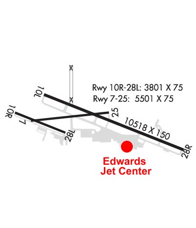
| Lat: N 4548.5 Long: W 10832.6 Elev: 3662 Var: -10 Longest Runway: 10518 | ||
| Clr Del: 121.9 Dept. ATIS: 126.3 Arr. ATIS: 126.3 Ground: 121.9 Tower: 127.2 | ||
| ||||||||||||||||||||||||||||||||||||||||||||||||||||||||||||||||||||
| ||||||||||||||||||||||||||||||||||||||||||||||||||||||||||||||||||||
| ||||||||||||||||||||||||||||||||||||||||||||||||||||||||||||||||||||
| ||||||||||||||||||||||||||||||||||||||||||||||||||||||||||||||||||||
| Rwy | Rwy | |||||||
| 5501x75 | 5501' | 5501x75 | 5501' | |||||
| 10518x150 | 10518' | 111.50 - 101° | 10518x150 | 10518' | 111.50 - 281° | |||
| 3800x75 | 3800' | 3800x75 | 3800' | |||||
| Runway ID | Single Wheel | Double Wheel | Double Tandem Wheel | Dual Double Wheel |
| 07/25 | 12,500 | N/A | N/A | N/A |
| 10L/28R | 120,000 | 214,000 | 365,000 | N/A |
| 10R/28L | 12,500 | N/A | N/A | N/A |
| These numbers are Advisory and are not limits. The Airport Manager should have more accurate Weight Limits | ||||
 Airport Diagram might not be current. | |
| Facility Name: | BILLINGS LOGAN INTL |
| City Name: | BILLINGS |
| County: | YELLOWSTONE |
| State abbrev: | MT |
| State Name: | MONTANA |
| Ownership: | PUBLICLY OWNED |
| Use: | OPEN TO THE PUBLIC |
| Owner's Name: | CITY OF BILLINGS |
| Address: | CITY HALL |
| BILLINGS, MT 59101 | |
| Owner's Phone: | 406-657-8495 |
| Manager's Name: | JEFF ROACH, MANAGER |
| Address: | 1901 TERMINAL CIRCLE DR., ROOM 216 |
| BILLINGS, MT 59105 | |
| Phone: | (406) 657-8484; 406-657-8495 |
| FAA Region: | NORTHWEST MOUNTAIN |
| FAA Field Office: | HLN |
| Date | Sunrise | Sunset |
|---|---|---|
| 12/29/25 Monday | 7:55 | 16:38 |
| 12/30/25 Tuesday | 7:55 | 16:38 |
| 12/31/25 Wednesday | 7:55 | 16:39 |
| 01/01/26 Thursday | 7:56 | 16:40 |
| 01/02/26 Friday | 7:56 | 16:41 |
| 01/03/26 Saturday | 7:56 | 16:42 |
| 01/04/26 Sunday | 7:55 | 16:43 |
| 01/05/26 Monday | 7:55 | 16:44 |
| 01/06/26 Tuesday | 7:55 | 16:45 |
| 01/07/26 Wednesday | 7:55 | 16:47 |
| 01/08/26 Thursday | 7:55 | 16:48 |
| 01/09/26 Friday | 7:54 | 16:49 |
| 01/10/26 Saturday | 7:54 | 16:50 |
| 01/11/26 Sunday | 7:54 | 16:51 |
| Airport Attendance Schedule | CONTINUOUS |
| Airport Status | OPERATIONAL (This Status can change at any time - please check NOTAMS) |
| Airport Lighting Schedule | ATC-CTL. FOR MIRL RYS 10R/28L & 07/25; HIRL RY 10L/28R; MALSR RY 10L & REIL RYS 25 & 28R - CTC ATCT. |
| Airport Storage Available | Tie Downs, Hanger |
| Extra Services Available | Air Freight, Air Ambulance, Avionics, Cargo Handling, Charter, Flight Instruction, Aircraft Rental, Aircraft Sales |
| Wind Indicator | YES - (lighted) |
| Control Tower | YES |
| CTAF Frequency | |
| Unicom Frequency | 122.950 |
| Rotating Beacon Color | WG |
| Segmented Circle | YES |
| Landing Fee | NO |
| Airport Inspected | FEDERAL - performed by FAA AIRPORTS FIELD PERSONNEL |
| Inspection Date | 07/17/2025 |
| Type of Fuel Available | Grade 100LL, JET A (freeze point -40C) |
| Airframe Repair Service | MAJOR |
| Power Plant Repair Service | MAJOR |
| Latitude | N4548.5 |
| Longitude | W10832.6 (ESTIMATED) |
| Arpt Elevation | 3662ft (SURVEYED) |
| Magnetic Variation | 10E |
| 2 miles NW | of BILLINGS |
| Traffic Pattern Altitude | SINGLE ENGINE ACFT 4500 (838), MULTI ENGINE/TURBOJET ACFT 5000 (1338). |
| Sectional Chart | BILLINGS |
| Operations (Reported) | Yearly | Avg. Daily |
|---|---|---|
| General Aviation Transient | 0 | 0 |
| General Aviation Local | 0 | 0 |
| Air Taxi | 0 | 0 |
| Commerical | 0 | 0 |
| Commuter | 0 | 0 |
| Military | 0 | 0 |
| Aircraft based on Field | |
|---|---|
| General Aviation Singles | 0 |
| General Aviation Multi | 0 |
| Jet Aircraft | 0 |
| General Aviation Helicopters | 0 |
| Military Aircraft | 0 |
| Gliders | 0 |
| Ultralights | 0 |
| FSS on field | NO |
| FSS tie-in | GREAT FALLS |
| FSS Phone | 1-800-WX-BRIEF |
| Who issues Notams | BIL |
| Notam D service at airport | YES |
| ARTCC Name | SALT LAKE CITY |
| Airport Certification | AIRPORT RECEIVING SCHEDULED AIR CARRIER SERVICE FROM CARRIERS CERTIFICATED BY THE CIVIL AERONAUTICS BOARD; PPR UNSKED ACR OPNS WITH MORE THAN 30 PSGR SEATS CTC ARPT OPS 406-657-8496. ARFF INDEX B 0200-0500. |
| Aircraft Rescue & Firefighting Index | AIRPORT HAS A CERTIFICATE UNDER CFR PART 139 |
| Airport of Entry | No |
| Custom Landing Rights | No |
| Joint Civil/Military | No |
| Military Landing rights | YES |
| NATIONAL PLAN OF INTEGRATED AIRPORT SYSTEMS (NPIAS) |
| GRANT AGREEMENTS UNDER FAAP/ADAP/AIP |
| ASSURANCES PURSUANT TO TITLE VI, CIVIL RIGHTS ACT OF 1964 |
| AGREEMENT UNDER DLAND OR DCLA HAS EXPIRED. |
| TWY D 35 FT WIDE CLSD TO ACFT OVER 12,500 LBS. |
| NO CUSTOMS, REMOTE ACFT PARKING, LTD GROUND HANDLING SVCS |
| PILOTS CONDUCTING EFVS OPS; BE AWARE LED ALS IN USE RWY 10L. |
| 180 DEG TURNS PROHIBITED ON ALL SFCS. |
| MIGRATORY WATERFOWL INVOF ARPT. |
| RYS 07/25 AND 10R/28L CLSD TO ACFT OVER 12,500 LBS. |
| RWY 07/2 5 PCR VALUE: 303/F/B/X/T |
| RWY 10L/ 28RPCR VALUE: 745/F/B/X/T |
| RWY 10R/ 28LPCR VALUE: 107/F/B/X/T |
Airport Communications & Frequencies:
| ||||||||||||||||||||||||||||||||||||||
| Runway: 07 | Runway: 25 | ||
| Mag heading: | 74° | Mag heading: | 254° |
| Rwy Slope: | -1.86% Down | Rwy Slope: | 1.86% Up |
| Approach: | Approach: | ||
| Pattern: | Left Traffic | Pattern: | Left Traffic |
| Markings: | NONPRECISION INSTRUMENT | Markings: | NONPRECISION INSTRUMENT |
| Marking Condition: | GOOD | Marking Condition: | GOOD |
| Arresting Dev: | Arresting Dev: | ||
| Lat & Long: | N4548.5 W10833.5 | Lat. & Long.: | N4548.6 W10832.2 |
| Elev: | 3636.3 ft. MSL | Elev: | 3533.8 ft. MSL |
| TCH: | 31 ft. AGL | TCH: | 36 ft. AGL |
| Visual Glide Path: | 3.00 degrees | Visual Glide Path: | 3.00 degrees |
| Displaced Threshold: | No | Displaced Threshold: | No |
| Touchdown Zone: | YES | Touchdown Zone: | YES |
| Touchdown Elev.: | 3636.3 feet | Touchdown Elev.: | 3585.6 feet |
| Visual Glide Slope: | 4-Light PAPI on LEFT side of Runway | Visual Glide Slope: | 4-Light PAPI on RIGHT side of Runway |
| RVR Equipment: | RVR Equipment: | ||
| RVV Equipment: | NO | RVV Equipment: | NO |
| Approach Lights: | Approach Lights: | ||
| REIL: | NO | REIL: | YES |
| Centerline Lights: | NO | Centerline Lights: | NO |
| Touchdown lights: | NO | Touchdown lights: | NO |
| Runway Category: | Runway with a Non-precision Approach | Runway Category: | Runway with a Non-precision Approach |
| Declared Distances: | TORA:5501' TODA:5501' ASDA:5501' LDA:5501' | Declared Distances: | TORA:5501' TODA:5501' ASDA:5501' LDA:5501' |
| Obstructions: | GND | Obstructions: | |
| Marked: | NOT Marked/Lighted | Marked: | |
| Clearance slope: | 20:1 | Clearance slope: | 20:1 |
| Obstruction height: | 20 feet AGL | Obstruction height: | |
| Dist. from runway: | 600 feet | Dist. from runway: | |
| Centerline offset: | Centerline offset: | ||
| Comments: | Comments: |
| Runway: 10L | Runway: 28R | ||
| Mag heading: | 101° | Mag heading: | 281° |
| Rwy Slope: | -.91% Down | Rwy Slope: | .91% Up |
| Approach: | ILS/DME | Approach: | ILS/DME |
| Pattern: | Left Traffic | Pattern: | Left Traffic |
| Markings: | PRECISION INSTRUMENT | Markings: | PRECISION INSTRUMENT |
| Marking Condition: | GOOD | Marking Condition: | GOOD |
| Arresting Dev: | Arresting Dev: | ||
| Lat & Long: | N4548.8 W10833.3 | Lat. & Long.: | N4548.1 W10831.0 |
| Elev: | 3584.4 ft. MSL | Elev: | 3488.2 ft. MSL |
| TCH: | 51 ft. AGL | TCH: | 56 ft. AGL |
| Visual Glide Path: | 3.00 degrees | Visual Glide Path: | 3.00 degrees |
| Displaced Threshold: | No | Displaced Threshold: | No |
| Touchdown Zone: | YES | Touchdown Zone: | YES |
| Touchdown Elev.: | 3584.5 feet | Touchdown Elev.: | 3517.2 feet |
| Visual Glide Slope: | 4-Light PAPI on LEFT side of Runway | Visual Glide Slope: | 4-Light PAPI on RIGHT side of Runway |
| RVR Equipment: | TOUCHDOWN | RVR Equipment: | ROLLOUT |
| RVV Equipment: | YES | RVV Equipment: | NO |
| Approach Lights: | MALSR - 1,400 foot medium intensity approach lighting system with runway alignment indicator lights | Approach Lights: | |
| REIL: | NO | REIL: | YES |
| Centerline Lights: | NO | Centerline Lights: | NO |
| Touchdown lights: | NO | Touchdown lights: | NO |
| Runway Category: | Precision Instrument Runway | Runway Category: | Precision Instrument Runway |
| Declared Distances: | TORA:10518' TODA:10518' ASDA:10518' LDA:10518' | Declared Distances: | TORA:10518' TODA:10518' ASDA:10518' LDA:10518' |
| Obstructions: | Obstructions: | GND | |
| Marked: | Marked: | NOT Marked/Lighted | |
| Clearance slope: | 50:1 | Clearance slope: | 34:1 |
| Obstruction height: | Obstruction height: | 12 feet AGL | |
| Dist. from runway: | Dist. from runway: | 200 feet | |
| Centerline offset: | Centerline offset: | 400 feet left of centerline | |
| Comments: | Comments: | +12' GND 0-200' FM RY END 400' L. |
| Runway: 10R | Runway: 28L | ||
| Mag heading: | 101° | Mag heading: | 281° |
| Rwy Slope: | -1.27% Down | Rwy Slope: | 1.27% Up |
| Approach: | Approach: | ||
| Pattern: | Left Traffic | Pattern: | Left Traffic |
| Markings: | BASIC | Markings: | BASIC |
| Marking Condition: | FAIR | Marking Condition: | FAIR |
| Arresting Dev: | Arresting Dev: | ||
| Lat & Long: | N4548.6 W10834.0 | Lat. & Long.: | N4548.4 W10833.1 |
| Elev: | 3662.3 ft. MSL | Elev: | 3614.0 ft. MSL |
| TCH: | TCH: | ||
| Visual Glide Path: | Visual Glide Path: | ||
| Displaced Threshold: | No | Displaced Threshold: | No |
| Touchdown Zone: | YES | Touchdown Zone: | YES |
| Touchdown Elev.: | 3651.6 feet | Touchdown Elev.: | 3641.0 feet |
| Visual Glide Slope: | Visual Glide Slope: | ||
| RVR Equipment: | RVR Equipment: | ||
| RVV Equipment: | NO | RVV Equipment: | NO |
| Approach Lights: | Approach Lights: | ||
| REIL: | NO | REIL: | NO |
| Centerline Lights: | NO | Centerline Lights: | NO |
| Touchdown lights: | NO | Touchdown lights: | NO |
| Runway Category: | Runway with a Visual Approach | Runway Category: | Runway with a Visual Approach |
| Declared Distances: | TORA:3801' TODA:3801' ASDA:3801' LDA:3801' | Declared Distances: | TORA:3801' TODA:3801' ASDA:3801' LDA:3801' |
| Obstructions: | GND | Obstructions: | |
| Marked: | NOT Marked/Lighted | Marked: | |
| Clearance slope: | 20:1 | Clearance slope: | 20:1 |
| Obstruction height: | 52 feet AGL | Obstruction height: | |
| Dist. from runway: | 2251 feet | Dist. from runway: | |
| Centerline offset: | Centerline offset: | ||
| Comments: | Comments: |
Thanks for using FltPlan.com
all rights reserved © 1999-2025 by Flight Plan LLC