
| NEW BRAUNFELS MUNI NEW BRAUNFELS TX |
| |
| Lat: N 2942.3 Long: W 09802.6 Elev: 658 Var: -08 Longest Runway: 6503 | ||
| Clr Del: 134.75 Dept. ATIS: 119.32 Arr. ATIS: 119.32 AWOS: 119.32 Ground: 120.17 Tower: 127.05 | ||
| ||||||||||||||||||||||||||||||||||||||||||||
| ||||||||||||||||||||||||||||||||||||||||||||
| ||||||||||||||||||||||||||||||||||||||||||||
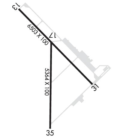
| Rwy | Rwy | |||||||
| 6503x100 | 6503' | 6503x100 | 6503' | |||||
| 5364x100 | 4842' | 5364x100 | 5364' | |||||
| Runway ID | Single Wheel | Double Wheel | Double Tandem Wheel | Dual Double Wheel |
| 13/31 | 30,000 | 60,000 | N/A | N/A |
| 17/35 | 25,000 | N/A | N/A | N/A |
| These numbers are Advisory and are not limits. The Airport Manager should have more accurate Weight Limits | ||||
 Airport Diagram might not be current. | |
| Facility Name: | NEW BRAUNFELS RGNL |
| City Name: | NEW BRAUNFELS |
| County: | GUADALUPE |
| State abbrev: | TX |
| State Name: | TEXAS |
| Ownership: | PUBLICLY OWNED |
| Use: | OPEN TO THE PUBLIC |
| Owner's Name: | CITY OF NEW BRAUNFELS |
| Address: | 550 LANDA ST. |
| NEW BRAUNFELS, TX 78130 | |
| Owner's Phone: | (830) 221-4000 |
| Manager's Name: | ROBERT LEE; AIRPORT DIRECTOR. |
| Address: | 2333 FM 758 |
| NEW BRAUNFELS, TX 78130 | |
| Phone: | 830-221-4290 |
| FAA Region: | SOUTHWEST |
| FAA Field Office: | TEX |
| Date | Sunrise | Sunset |
|---|---|---|
| 09/24/21 Friday | 7:21 | 19:26 |
| 09/25/21 Saturday | 7:22 | 19:25 |
| 09/26/21 Sunday | 7:23 | 19:24 |
| 09/27/21 Monday | 7:23 | 19:23 |
| 09/28/21 Tuesday | 7:24 | 19:22 |
| 09/29/21 Wednesday | 7:24 | 19:20 |
| 09/30/21 Thursday | 7:25 | 19:19 |
| 10/01/21 Friday | 7:25 | 19:18 |
| 10/02/21 Saturday | 7:26 | 19:17 |
| 10/03/21 Sunday | 7:26 | 19:16 |
| 10/04/21 Monday | 7:27 | 19:14 |
| 10/05/21 Tuesday | 7:28 | 19:13 |
| 10/06/21 Wednesday | 7:28 | 19:12 |
| 10/07/21 Thursday | 7:29 | 19:11 |
| Airport Attendance Schedule | 7 Days A Week 0700-1900 |
| Airport Status | OPERATIONAL (This Status can change at any time - please check NOTAMS) |
| Airport Lighting Schedule | ACTVT MIRL RWYS 13/31 & 17/35 - CTAF. |
| Airport Storage Available | Tie Downs, Hanger |
| Extra Services Available | Charter, Flight Instruction, Aircraft Rental |
| Wind Indicator | YES - (lighted) |
| Control Tower | YES |
| CTAF Frequency | 127.050 |
| Unicom Frequency | 122.700 |
| Rotating Beacon Color | CLEAR-GREEN (Light Land Airport) |
| Segmented Circle | YES |
| Landing Fee | NO |
| Airport Inspected | STATE - performed by STATE AERONAUTICAL PERSONNEL |
| Inspection Date | 01/05/2017 |
| Type of Fuel Available | Grade 100LL, JET A (freeze point -40C), JET A; -10FOR FUEL CALL 830-221-4290; AFT HRS CALL 830-221-4100. 24 HR SELF SVC AVBL WITH MAJOR CREDIT CARD. |
| Airframe Repair Service | NONE |
| Power Plant Repair Service | NONE |
| Latitude | N2942.3 |
| Longitude | W09802.6 (ESTIMATED) |
| Arpt Elevation | 658ft (SURVEYED) |
| Magnetic Variation | 08E |
| 4 miles E | of NEW BRAUNFELS |
| Traffic Pattern Altitude | |
| Sectional Chart | SAN ANTONIO |
| Operations (Reported) | Yearly | Avg. Daily |
|---|---|---|
| General Aviation Transient | 20330 | 56 |
| General Aviation Local | 22606 | 62 |
| Air Taxi | 838 | 2 |
| Commerical | 0 | 0 |
| Commuter | 0 | 0 |
| Military | 8767 | 24 |
| Aircraft based on Field | |
|---|---|
| General Aviation Singles | 108 |
| General Aviation Multi | 13 |
| Jet Aircraft | 18 |
| General Aviation Helicopters | 6 |
| Military Aircraft | 0 |
| Gliders | 0 |
| Ultralights | 0 |
| FSS on field | NO |
| FSS tie-in | SAN ANGELO |
| FSS Phone | 1-800-WX-BRIEF |
| Who issues Notams | BAZ |
| Notam D service at airport | YES |
| ARTCC Name | HOUSTON |
| Airport Certification | |
| Aircraft Rescue & Firefighting Index | None |
| Airport of Entry | No |
| Custom Landing Rights | No |
| Joint Civil/Military | No |
| Military Landing rights | YES |
| NATIONAL PLAN OF INTEGRATED AIRPORT SYSTEMS (NPIAS) |
| GRANT AGREEMENTS UNDER FAAP/ADAP/AIP |
| SURPLUS PROPERTY AGREEMENT UNDER PUBLIC LAW 289 |
| ASSURANCES PURSUANT TO TITLE VI, CIVIL RIGHTS ACT OF 1964 |
| NUMEROUS BIRDS INVOF ARPT. |
| HIGH PERFORMANCE MILITARY ACFT OPERATING AT RANDOLPH AFB AUX (SEGUIN) AIRFIELD. |
| FOR CD WHEN ATCT IS CLSD CTC SAT APCH AT 210-805-5516. |
| HELICOPTERS RIGHT TFC. |
Airport Communications & Frequencies:
| ||||||||||||||||||||||||||
| Runway: 13 | Runway: 31 | ||
| Mag heading: | 128° | Mag heading: | 308° |
| Rwy Slope: | -.23% Down | Rwy Slope: | .23% Up |
| Approach: | Approach: | ||
| Pattern: | Left Traffic | Pattern: | Left Traffic |
| Markings: | NONPRECISION INSTRUMENT | Markings: | NONPRECISION INSTRUMENT |
| Marking Condition: | GOOD | Marking Condition: | GOOD |
| Arresting Dev: | Arresting Dev: | ||
| Lat & Long: | N2942.9 W09803.0 | Lat. & Long.: | N2942.1 W09802.1 |
| Elev: | 658.4 ft. MSL | Elev: | 643.5 ft. MSL |
| TCH: | 50 ft. AGL | TCH: | 50 ft. AGL |
| Visual Glide Path: | 3.00 degrees | Visual Glide Path: | 3.00 degrees |
| Displaced Threshold: | No | Displaced Threshold: | No |
| Touchdown Zone: | YES | Touchdown Zone: | YES |
| Touchdown Elev.: | 658.4 feet | Touchdown Elev.: | 646.0 feet |
| Visual Glide Slope: | 4-Light PAPI on LEFT side of Runway | Visual Glide Slope: | 4-Light PAPI on LEFT side of Runway |
| RVR Equipment: | RVR Equipment: | ||
| RVV Equipment: | NO | RVV Equipment: | NO |
| Approach Lights: | MALS - 1,400 foot medium intensity approach lighting system | Approach Lights: | |
| REIL: | YES | REIL: | NO |
| Centerline Lights: | NO | Centerline Lights: | NO |
| Touchdown lights: | NO | Touchdown lights: | NO |
| Runway Category: | D | Runway Category: | D |
| Declared Distances: | Declared Distances: | ||
| Obstructions: | Obstructions: | TREE | |
| Marked: | Marked: | NOT Marked/Lighted | |
| Clearance slope: | 50:1 | Clearance slope: | 35:1 |
| Obstruction height: | Obstruction height: | 22 feet AGL | |
| Dist. from runway: | Dist. from runway: | 975 feet | |
| Centerline offset: | Centerline offset: | 235 feet left of centerline | |
| Comments: | Comments: |
| Runway: 17 | Runway: 35 | ||
| Mag heading: | 173° | Mag heading: | 353° |
| Rwy Slope: | -.04% Down | Rwy Slope: | .04% Up |
| Approach: | Approach: | ||
| Pattern: | Left Traffic | Pattern: | Left Traffic |
| Markings: | NONPRECISION INSTRUMENT | Markings: | NONPRECISION INSTRUMENT |
| Marking Condition: | FAIR | Marking Condition: | FAIR |
| Arresting Dev: | Arresting Dev: | ||
| Lat & Long: | N2942.6 W09802.6 | Lat. & Long.: | N2941.7 W09802.6 |
| Elev: | 646.6 ft. MSL | Elev: | 644.5 ft. MSL |
| TCH: | TCH: | ||
| Visual Glide Path: | Visual Glide Path: | ||
| Displaced Threshold: | 522 feet | Displaced Threshold: | No |
| Touchdown Zone: | YES | Touchdown Zone: | YES |
| Touchdown Elev.: | 650.5 feet | Touchdown Elev.: | 649.5 feet |
| Visual Glide Slope: | Visual Glide Slope: | ||
| RVR Equipment: | RVR Equipment: | ||
| RVV Equipment: | NO | RVV Equipment: | NO |
| Approach Lights: | Approach Lights: | ||
| REIL: | NO | REIL: | NO |
| Centerline Lights: | NO | Centerline Lights: | NO |
| Touchdown lights: | NO | Touchdown lights: | NO |
| Runway Category: | Runway with a Non-precision Approach having visibility minimums greater than 3/4 mile | Runway Category: | Runway with a Non-precision Approach having visibility minimums greater than 3/4 mile |
| Declared Distances: | Declared Distances: |
Thanks for using FltPlan.com
all rights reserved © 1999-2021 by Flight Plan LLC
