| WAYCROSS-WARE COUNTY WAYCROSS GA |
| |
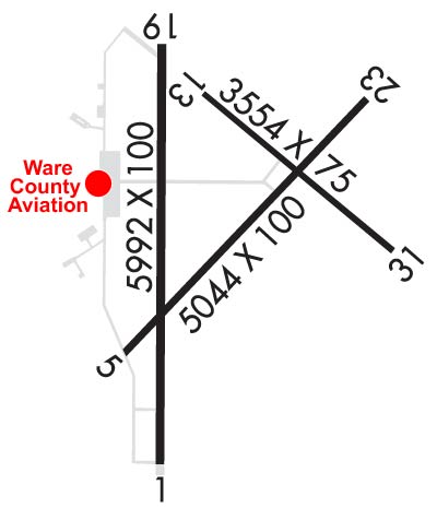
| Lat: N 3114.9 Long: W 08223.7 Elev: 141 Var: +05 Longest Runway: 5992 | ||
| Clr Del: 121.72 (GCO) AWOS: 118.57 CTAF: 122.8 | ||
| ||||||||||||||||||||||||||||||||||||||||||||||||||||||||||||||||||||
| ||||||||||||||||||||||||||||||||||||||||||||||||||||||||||||||||||||
| ||||||||||||||||||||||||||||||||||||||||||||||||||||||||||||||||||||
| Rwy | Rwy | |||||||
| 5992x100 | 5992' | 5992x100 | 5992' | 108.30 - 184° | ||||
| 5044x100 | 5044' | 5044x100 | 5044' | |||||
| 3554x75 | 3554' | 3554x75 | 3554' | |||||
| Runway ID | Single Wheel | Double Wheel | Double Tandem Wheel | Dual Double Wheel |
| 01/19 | 45,000 | 70,000 | N/A | N/A |
| 05/23 | 18,000 | N/A | N/A | N/A |
| 13/31 | 18,000 | N/A | N/A | N/A |
| These numbers are Advisory and are not limits. The Airport Manager should have more accurate Weight Limits | ||||
 Airport Diagram might not be current. | |
| Facility Name: | WAYCROSS-WARE COUNTY |
| City Name: | WAYCROSS |
| County: | WARE |
| State abbrev: | GA |
| State Name: | GEORGIA |
| Ownership: | PUBLICLY OWNED |
| Use: | OPEN TO THE PUBLIC |
| Owner's Name: | WARE COUNTY |
| Address: | 800 CHURCH STREET, SUITE 223 |
| WAYCROSS, GA 31501 | |
| Owner's Phone: | 912-287-4300 |
| Manager's Name: | WILLIAM (BILL) STRICKLAND |
| Address: | 3098 KEEN DRIVE |
| WAYCROSS, GA 31503 | |
| Phone: | 912-287-4400; ADDL PHONE 912-287-4401 FAX & 912-287-4392 AFTER HOURS. |
| FAA Region: | SOUTHERN |
| FAA Field Office: | ATL |
| Date | Sunrise | Sunset |
|---|---|---|
| 09/24/21 Friday | 7:19 | 19:24 |
| 09/25/21 Saturday | 7:19 | 19:23 |
| 09/26/21 Sunday | 7:20 | 19:21 |
| 09/27/21 Monday | 7:21 | 19:20 |
| 09/28/21 Tuesday | 7:21 | 19:19 |
| 09/29/21 Wednesday | 7:22 | 19:17 |
| 09/30/21 Thursday | 7:22 | 19:16 |
| 10/01/21 Friday | 7:23 | 19:15 |
| 10/02/21 Saturday | 7:24 | 19:14 |
| 10/03/21 Sunday | 7:24 | 19:12 |
| 10/04/21 Monday | 7:25 | 19:11 |
| 10/05/21 Tuesday | 7:26 | 19:10 |
| 10/06/21 Wednesday | 7:26 | 19:09 |
| 10/07/21 Thursday | 7:27 | 19:07 |
| Airport Attendance Schedule | M-F 0800-1630 |
| Airport Status | OPERATIONAL (This Status can change at any time - please check NOTAMS) |
| Airport Lighting Schedule | DUSK-2200; AFTER 2200, ACTVT MALSR RWY 19; REIL RWY 19; PAPI RWY 01 & 19; HIRL RWY 01/19 - CTAF. |
| Airport Storage Available | Tie Downs, Hanger |
| Extra Services Available | NONE |
| Wind Indicator | YES - (lighted) |
| Control Tower | NO |
| CTAF Frequency | 122.800 |
| Unicom Frequency | 122.800 |
| Rotating Beacon Color | CLEAR-GREEN (Light Land Airport) |
| Segmented Circle | YES |
| Landing Fee | NO |
| Airport Inspected | STATE - performed by STATE AERONAUTICAL PERSONNEL |
| Inspection Date | 12/29/2020 |
| Type of Fuel Available | Grade 100LL, JET A; -10FOR FUEL AFTER HRS CALL 912-287-4335. |
| Airframe Repair Service | NONE |
| Power Plant Repair Service | NONE |
| Latitude | N3114.9 |
| Longitude | W08223.7 (ESTIMATED) |
| Arpt Elevation | 141ft (SURVEYED) |
| Magnetic Variation | 05W |
| 3 miles NW | of WAYCROSS |
| Traffic Pattern Altitude | |
| Sectional Chart | JACKSONVILLE |
| Operations (Reported) | Yearly | Avg. Daily |
|---|---|---|
| General Aviation Transient | 7500 | 21 |
| General Aviation Local | 10000 | 27 |
| Air Taxi | 0 | 0 |
| Commerical | 0 | 0 |
| Commuter | 0 | 0 |
| Military | 500 | 1 |
| Aircraft based on Field | |
|---|---|
| General Aviation Singles | 25 |
| General Aviation Multi | 1 |
| Jet Aircraft | 1 |
| General Aviation Helicopters | 0 |
| Military Aircraft | 0 |
| Gliders | 0 |
| Ultralights | 0 |
| FSS on field | NO |
| FSS tie-in | MACON |
| FSS Phone | 1-800-WX-BRIEF |
| Who issues Notams | AYS |
| Notam D service at airport | YES |
| ARTCC Name | JACKSONVILLE |
| Airport Certification | |
| Aircraft Rescue & Firefighting Index | None |
| Airport of Entry | No |
| Custom Landing Rights | No |
| Joint Civil/Military | No |
| Military Landing rights | YES |
| NATIONAL PLAN OF INTEGRATED AIRPORT SYSTEMS (NPIAS) |
| GRANT AGREEMENTS UNDER FAAP/ADAP/AIP |
| SURPLUS PROPERTY AGREEMENT UNDER REGULATION 16-WAA |
| ASSURANCES PURSUANT TO TITLE VI, CIVIL RIGHTS ACT OF 1964 |
| AGREEMENT UNDER DLAND OR DCLA HAS EXPIRED. |
| THIS AIRPORT HAS BEEN SURVEYED BY THE NATIONAL GEODETIC SURVEY. |
| 1089 FT TOWER 9.5 NM WEST OF ARPT. |
| FOR CD CTC JACKSONVILLE ARTCC AT 904-845-1592. |
Airport Communications & Frequencies:
| |||||||||
| Runway: 01 | Runway: 19 | ||
| Mag heading: | 4° | Mag heading: | 184° |
| Rwy Slope: | .09% Up | Rwy Slope: | -.09% Down |
| Approach: | Approach: | ILS | |
| Pattern: | Left Traffic | Pattern: | Left Traffic |
| Markings: | PRECISION INSTRUMENT | Markings: | PRECISION INSTRUMENT |
| Marking Condition: | FAIR | Marking Condition: | FAIR |
| Arresting Dev: | Arresting Dev: | ||
| Lat & Long: | N3114.3 W08223.9 | Lat. & Long.: | N3115.3 W08223.9 |
| Elev: | 133.9 ft. MSL | Elev: | 139.0 ft. MSL |
| TCH: | 33 ft. AGL | TCH: | 45 ft. AGL |
| Visual Glide Path: | 3.00 degrees | Visual Glide Path: | 3.00 degrees |
| Displaced Threshold: | No | Displaced Threshold: | No |
| Touchdown Zone: | YES | Touchdown Zone: | YES |
| Touchdown Elev.: | 140.4 feet | Touchdown Elev.: | 140.4 feet |
| Visual Glide Slope: | 2-Light PAPI on LEFT side of Runway | Visual Glide Slope: | 2-Light PAPI on LEFT side of Runway |
| RVR Equipment: | RVR Equipment: | ||
| RVV Equipment: | NO | RVV Equipment: | NO |
| Approach Lights: | Approach Lights: | MALSR - 1,400 foot medium intensity approach lighting system with runway alignment indicator lights | |
| REIL: | NO | REIL: | YES |
| Centerline Lights: | NO | Centerline Lights: | NO |
| Touchdown lights: | NO | Touchdown lights: | NO |
| Runway Category: | Runway with a Non-precision Approach having visibility minimums greater than 3/4 mile | Runway Category: | Precision Instrument Runway |
| Declared Distances: | Declared Distances: | ||
| Obstructions: | TREES | Obstructions: | |
| Marked: | NOT Marked/Lighted | Marked: | |
| Clearance slope: | 34:1 | Clearance slope: | 50:1 |
| Obstruction height: | 33 feet AGL | Obstruction height: | |
| Dist. from runway: | 1322 feet | Dist. from runway: | |
| Centerline offset: | 487 left of centerline | Centerline offset: | |
| Comments: | Comments: |
| Runway: 05 | Runway: 23 | ||
| Mag heading: | 47° | Mag heading: | 227° |
| Rwy Slope: | -.08% Down | Rwy Slope: | .08% Up |
| Approach: | Approach: | ||
| Pattern: | Left Traffic | Pattern: | Left Traffic |
| Markings: | BASIC | Markings: | BASIC |
| Marking Condition: | GOOD | Marking Condition: | GOOD |
| Arresting Dev: | Arresting Dev: | ||
| Lat & Long: | N3114.6 W08224.0 | Lat. & Long.: | N3115.2 W08223.3 |
| Elev: | 140.2 ft. MSL | Elev: | 136.3 ft. MSL |
| TCH: | TCH: | ||
| Visual Glide Path: | Visual Glide Path: | ||
| Displaced Threshold: | No | Displaced Threshold: | No |
| Touchdown Zone: | YES | Touchdown Zone: | YES |
| Touchdown Elev.: | 140.4 feet | Touchdown Elev.: | 137.9 feet |
| Visual Glide Slope: | Visual Glide Slope: | ||
| RVR Equipment: | RVR Equipment: | ||
| RVV Equipment: | NO | RVV Equipment: | NO |
| Approach Lights: | Approach Lights: | ||
| REIL: | NO | REIL: | NO |
| Centerline Lights: | NO | Centerline Lights: | NO |
| Touchdown lights: | NO | Touchdown lights: | NO |
| Runway Category: | Runway with a Visual Approach | Runway Category: | Runway with a Visual Approach |
| Declared Distances: | Declared Distances: | ||
| Obstructions: | TREES | Obstructions: | TREES |
| Marked: | NOT Marked/Lighted | Marked: | NOT Marked/Lighted |
| Clearance slope: | 25:1 | Clearance slope: | 34:1 |
| Obstruction height: | 42 feet AGL | Obstruction height: | 35 feet AGL |
| Dist. from runway: | 1250 feet | Dist. from runway: | 1390 feet |
| Centerline offset: | 300 right of centerline | Centerline offset: | |
| Comments: | Comments: |
| Runway: 13 | Runway: 31 | ||
| Mag heading: | 133° | Mag heading: | 313° |
| Rwy Slope: | -.08% Down | Rwy Slope: | .08% Up |
| Approach: | Approach: | ||
| Pattern: | Left Traffic | Pattern: | Left Traffic |
| Markings: | BASIC | Markings: | BASIC |
| Marking Condition: | GOOD | Marking Condition: | GOOD |
| Arresting Dev: | Arresting Dev: | ||
| Lat & Long: | N3115.2 W08223.8 | Lat. & Long.: | N3114.8 W08223.3 |
| Elev: | 140.6 ft. MSL | Elev: | 137.8 ft. MSL |
| TCH: | TCH: | ||
| Visual Glide Path: | Visual Glide Path: | ||
| Displaced Threshold: | No | Displaced Threshold: | No |
| Touchdown Zone: | YES | Touchdown Zone: | YES |
| Touchdown Elev.: | 141.3 feet | Touchdown Elev.: | 141.3 feet |
| Visual Glide Slope: | Visual Glide Slope: | ||
| RVR Equipment: | RVR Equipment: | ||
| RVV Equipment: | NO | RVV Equipment: | NO |
| Approach Lights: | Approach Lights: | ||
| REIL: | NO | REIL: | NO |
| Centerline Lights: | NO | Centerline Lights: | NO |
| Touchdown lights: | NO | Touchdown lights: | NO |
| Runway Category: | Runway with a Visual Approach | Runway Category: | Runway with a Visual Approach |
| Declared Distances: | Declared Distances: | ||
| Obstructions: | Obstructions: | TREES | |
| Marked: | Marked: | NOT Marked/Lighted | |
| Clearance slope: | 50:1 | Clearance slope: | 25:1 |
| Obstruction height: | Obstruction height: | 57 feet AGL | |
| Dist. from runway: | Dist. from runway: | 1625 feet | |
| Centerline offset: | Centerline offset: | ||
| Comments: | Comments: |
Thanks for using FltPlan.com
all rights reserved © 1999-2021 by Flight Plan LLC