
| AKRON FULTON INTL AKRON OH |
| |
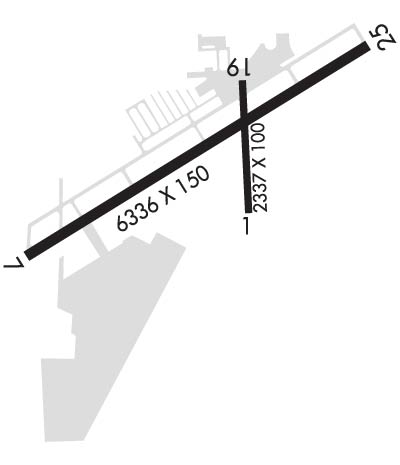
| Lat: N 4102.3 Long: W 08128.0 Elev: 1068 Var: +07 Longest Runway: 6336 | ||
| Clr Del: 121.6 AWOS: 126.82 CTAF: 123.07 | ||
| ||||||
| ||||||
|
| Rwy | Rwy | |||||||
| 2337x100 | 2337' | 2337x100 | 2145' | |||||
| 6336x150 | 5576' | 6336x150 | 6077' | 110.90 - 248° | ||||
| Runway ID | Single Wheel | Double Wheel | Double Tandem Wheel | Dual Double Wheel |
| 01/19 | 30,000 | N/A | N/A | N/A |
| 07/25 | 75,000 | 100,000 | 160,000 | N/A |
| These numbers are Advisory and are not limits. The Airport Manager should have more accurate Weight Limits | ||||
 Airport Diagram might not be current. | |
| Facility Name: | AKRON FULTON INTL |
| City Name: | AKRON |
| County: | SUMMIT |
| State abbrev: | OH |
| State Name: | OHIO |
| Ownership: | PUBLICLY OWNED |
| Use: | OPEN TO THE PUBLIC |
| Owner's Name: | CITY OF AKRON |
| Address: | 166 S HIGH ST RM 701 |
| AKRON, OH 44308-1627 | |
| Owner's Phone: | 330-375-2355 |
| Manager's Name: | ANTHONY PLUCINSKI; TONYP@SUMMITAVIATIONSERVICES.COM. |
| Address: | 1600 TRIPLETT BLVD |
| AKRON, OH 44306-3308 | |
| Phone: | 330-733-4760 |
| FAA Region: | GREAT LAKES |
| FAA Field Office: | DET |
| Date | Sunrise | Sunset |
|---|---|---|
| 09/24/21 Friday | 7:15 | 19:20 |
| 09/25/21 Saturday | 7:16 | 19:18 |
| 09/26/21 Sunday | 7:17 | 19:17 |
| 09/27/21 Monday | 7:18 | 19:15 |
| 09/28/21 Tuesday | 7:19 | 19:13 |
| 09/29/21 Wednesday | 7:20 | 19:12 |
| 09/30/21 Thursday | 7:21 | 19:10 |
| 10/01/21 Friday | 7:22 | 19:08 |
| 10/02/21 Saturday | 7:23 | 19:07 |
| 10/03/21 Sunday | 7:24 | 19:05 |
| 10/04/21 Monday | 7:25 | 19:03 |
| 10/05/21 Tuesday | 7:26 | 19:02 |
| 10/06/21 Wednesday | 7:27 | 19:00 |
| 10/07/21 Thursday | 7:28 | 18:58 |
| Airport Attendance Schedule | CONTINUOUS |
| Airport Status | OPERATIONAL (This Status can change at any time - please check NOTAMS) |
| Airport Lighting Schedule | ACTVT REIL RWY 07 & 25; PAPI RWY 07 & 25; HIRL RWY 07/25; MIRL RWY 01/19 - CTAF. |
| Airport Storage Available | Tie Downs, Hanger |
| Extra Services Available | Charter, Flight Instruction, Aircraft Rental |
| Wind Indicator | YES - (lighted) |
| Control Tower | NO |
| CTAF Frequency | 123.075 |
| Unicom Frequency | 123.075 |
| Rotating Beacon Color | CLEAR-GREEN (Light Land Airport) |
| Segmented Circle | NO |
| Landing Fee | NO |
| Airport Inspected | STATE - performed by STATE AERONAUTICAL PERSONNEL |
| Inspection Date | 05/23/2019 |
| Type of Fuel Available | Grade 100LL, JET A (freeze point -40C) |
| Airframe Repair Service | MAJOR |
| Power Plant Repair Service | MAJOR |
| Latitude | N4102.3 |
| Longitude | W08128.0 (ESTIMATED) |
| Arpt Elevation | 1067ft (SURVEYED) |
| Magnetic Variation | 07W |
| 4 miles SE | of AKRON |
| Traffic Pattern Altitude | |
| Sectional Chart | DETROIT |
| Operations (Reported) | Yearly | Avg. Daily |
|---|---|---|
| General Aviation Transient | 17150 | 47 |
| General Aviation Local | 33150 | 91 |
| Air Taxi | 600 | 2 |
| Commerical | 0 | 0 |
| Commuter | 0 | 0 |
| Military | 30 | 0 |
| Aircraft based on Field | |
|---|---|
| General Aviation Singles | 78 |
| General Aviation Multi | 10 |
| Jet Aircraft | 3 |
| General Aviation Helicopters | 2 |
| Military Aircraft | 0 |
| Gliders | 0 |
| Ultralights | 0 |
| FSS on field | NO |
| FSS tie-in | CLEVELAND |
| FSS Phone | 1-800-WX-BRIEF |
| Who issues Notams | AKR |
| Notam D service at airport | YES |
| ARTCC Name | CLEVELAND |
| Airport Certification | |
| Aircraft Rescue & Firefighting Index | None |
| Airport of Entry | No |
| Custom Landing Rights | No |
| Joint Civil/Military | No |
| Military Landing rights | YES |
| NATIONAL PLAN OF INTEGRATED AIRPORT SYSTEMS (NPIAS) |
| GRANT AGREEMENTS UNDER FAAP/ADAP/AIP |
| SURPLUS PROPERTY AGREEMENT UNDER REGULATION 16-WAA |
| ASSURANCES PURSUANT TO TITLE VI, CIVIL RIGHTS ACT OF 1964 |
| FOR CD CTC CLEVELAND APCH AT 216-352-2323, WHEN APCH CLSD CTC CLEVELAND ARTCC AT 440-774-0223. |
| DEER ON & INVOF ARPT. |
Airport Communications & Frequencies:
| |||||||||||||||||||
| Runway: 01 | Runway: 19 | ||
| Mag heading: | 8° | Mag heading: | 188° |
| Rwy Slope: | -.01% Down | Rwy Slope: | .01% Up |
| Approach: | Approach: | ||
| Pattern: | Left Traffic | Pattern: | Left Traffic |
| Markings: | BASIC | Markings: | BASIC |
| Marking Condition: | POOR; FADED. | Marking Condition: | POOR; FADED. |
| Arresting Dev: | Arresting Dev: | ||
| Lat & Long: | N4102.1 W08127.9 | Lat. & Long.: | N4102.5 W08127.9 |
| Elev: | 1043.6 ft. MSL | Elev: | 1043.3 ft. MSL |
| TCH: | TCH: | ||
| Visual Glide Path: | Visual Glide Path: | ||
| Displaced Threshold: | No | Displaced Threshold: | 192 feet |
| Touchdown Zone: | YES | Touchdown Zone: | YES |
| Touchdown Elev.: | 1045.2 feet | Touchdown Elev.: | 1045.2 feet |
| Visual Glide Slope: | Visual Glide Slope: | ||
| RVR Equipment: | RVR Equipment: | ||
| RVV Equipment: | NO | RVV Equipment: | NO |
| Approach Lights: | Approach Lights: | ||
| REIL: | NO | REIL: | NO |
| Centerline Lights: | NO | Centerline Lights: | NO |
| Touchdown lights: | NO | Touchdown lights: | NO |
| Runway Category: | Runway with a Visual Approach | Runway Category: | Runway with a Visual Approach |
| Declared Distances: | Declared Distances: | ||
| Obstructions: | FENCE | Obstructions: | TREES |
| Marked: | NOT Marked/Lighted | Marked: | NOT Marked/Lighted |
| Clearance slope: | 20:1 | Clearance slope: | 17:1; OBSTN CLNC SLP 24:1 TO DTHR. |
| Obstruction height: | 60 feet AGL | Obstruction height: | 50 feet AGL |
| Dist. from runway: | 1400 feet | Dist. from runway: | 1050 feet |
| Centerline offset: | Centerline offset: | 130 feet right of centerline | |
| Comments: | Comments: |
| Runway: 07 | Runway: 25 | ||
| Mag heading: | 69° | Mag heading: | 249° |
| Rwy Slope: | -.10% Down | Rwy Slope: | .10% Up |
| Approach: | Approach: | LOC/DME | |
| Pattern: | Left Traffic | Pattern: | Left Traffic |
| Markings: | NONPRECISION INSTRUMENT | Markings: | NONPRECISION INSTRUMENT |
| Marking Condition: | GOOD | Marking Condition: | GOOD |
| Arresting Dev: | Arresting Dev: | ||
| Lat & Long: | N4102.0 W08128.7 | Lat. & Long.: | N4102.5 W08127.5 |
| Elev: | 1067.5 ft. MSL | Elev: | 1060.9 ft. MSL |
| TCH: | 45 ft. AGL | TCH: | 45 ft. AGL |
| Visual Glide Path: | 3.60 degrees | Visual Glide Path: | 4.00 degrees |
| Displaced Threshold: | 760 feet | Displaced Threshold: | 259 feet |
| Touchdown Zone: | YES | Touchdown Zone: | YES |
| Touchdown Elev.: | 1055.3 feet | Touchdown Elev.: | 1059.1 feet |
| Visual Glide Slope: | 4-Light PAPI on LEFT side of Runway | Visual Glide Slope: | 4-Light PAPI on LEFT side of Runway |
| RVR Equipment: | RVR Equipment: | ||
| RVV Equipment: | NO | RVV Equipment: | NO |
| Approach Lights: | Approach Lights: | ||
| REIL: | YES | REIL: | YES |
| Centerline Lights: | NO | Centerline Lights: | NO |
| Touchdown lights: | NO | Touchdown lights: | NO |
| Runway Category: | Runway with a Visual Approach | Runway Category: | Runway with a Non-precision Approach having visibility minimums greater than 3/4 mile |
| Declared Distances: | Declared Distances: | ||
| Obstructions: | RR | Obstructions: | TREES |
| Marked: | NOT Marked/Lighted | Marked: | NOT Marked/Lighted |
| Clearance slope: | APCH RATIO 24:1 TO DTHR DUE TO +110 FT MOUND 2740 FT FM THLD 180 FT L. | Clearance slope: | 23:1; OBSTN CLNC SLP 30:1 TO DTHR. |
| Obstruction height: | 23 feet AGL | Obstruction height: | 70 feet AGL |
| Dist. from runway: | 201 feet | Dist. from runway: | 1875 feet |
| Centerline offset: | 140 right of centerline | Centerline offset: | 480 feet left of centerline |
| Comments: | 23 FT RR, 0-200 FT DIST, 155 FT L TO 140 FT R. | Comments: |
Thanks for using FltPlan.com
all rights reserved © 1999-2021 by Flight Plan LLC
