
| APALACHICOLA REGIONAL APALACHICOLA FL |
| |
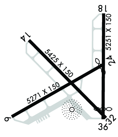
| Lat: N 2943.7 Long: W 08501.6 Elev: 20 Var: +03 Longest Runway: 5425 | ||
| AWOS: 119.92 CTAF: 122.8 | ||
| ||||||||||||||||||||||||||||||||||||||||||||
| ||||||||||||||||||||||||||||||||||||||||||||
| ||||||||||||||||||||||||||||||||||||||||||||
| Rwy | Rwy | |||||||
| 5271x150 | 5271' | 5271x150 | 5054' | |||||
| 5425x150 | 5425' | 5425x150 | 5425' | |||||
| 5251x150 | 5251' | 5251x150 | 4749' | |||||
| Runway ID | Single Wheel | Double Wheel | Double Tandem Wheel | Dual Double Wheel |
| 06/24 | N/A | N/A | N/A | N/A |
| 14/32 | N/A | N/A | N/A | N/A |
| 18/36 | N/A | N/A | N/A | N/A |
| These numbers are Advisory and are not limits. The Airport Manager should have more accurate Weight Limits | ||||
 Airport Diagram might not be current. | |
| Facility Name: | APALACHICOLA RGNL-CLEVE RANDOLPH FLD |
| City Name: | APALACHICOLA |
| County: | FRANKLIN |
| State abbrev: | FL |
| State Name: | FLORIDA |
| Ownership: | PUBLICLY OWNED |
| Use: | OPEN TO THE PUBLIC |
| Owner's Name: | FRANKLIN COUNTY |
| Address: | 33 MARKET STREET, SUITE 203 |
| APALACHICOLA, FL 32320-2317 | |
| Owner's Phone: | 850-653-9783 |
| Manager's Name: | STEVE KIRSCHENBAUM; AIRPORT PHYSICAL ADDRESS: 8 AIRPORT ROAD, APALACHICOLA, FL 32320 850-653-7270 FAX: 850-653-1335. |
| Address: | 8 AIRPORT ROAD |
| APALACHICOLA, FL 32320-2317 | |
| Phone: | 850-290-8282 |
| FAA Region: | SOUTHERN |
| FAA Field Office: | ORL |
| Date | Sunrise | Sunset |
|---|---|---|
| 05/31/26 Sunday | 6:40 | 20:35 |
| 06/01/26 Monday | 6:40 | 20:36 |
| 06/02/26 Tuesday | 6:40 | 20:36 |
| 06/03/26 Wednesday | 6:40 | 20:37 |
| 06/04/26 Thursday | 6:40 | 20:37 |
| 06/05/26 Friday | 6:39 | 20:38 |
| 06/06/26 Saturday | 6:39 | 20:38 |
| 06/07/26 Sunday | 6:39 | 20:39 |
| 06/08/26 Monday | 6:39 | 20:39 |
| 06/09/26 Tuesday | 6:39 | 20:40 |
| 06/10/26 Wednesday | 6:39 | 20:40 |
| 06/11/26 Thursday | 6:39 | 20:41 |
| 06/12/26 Friday | 6:39 | 20:41 |
| 06/13/26 Saturday | 6:39 | 20:41 |
| Airport Attendance Schedule | 7 Days A Week 0800-1900 |
| Airport Status | OPERATIONAL (This Status can change at any time - please check NOTAMS) |
| Airport Lighting Schedule | ACTVT PAPI RWY 6, 24, 14, & 32; MIRL RWY 06/24 & 14/32 - CTAF. |
| Airport Storage Available | Tie Downs, Hanger |
| Extra Services Available | Avionics, Charter, Flight Instruction, Aircraft Rental, Aircraft Sales |
| Wind Indicator | YES - (lighted) |
| Control Tower | NO |
| CTAF Frequency | 122.800 |
| Unicom Frequency | 122.800 |
| Rotating Beacon Color | WG |
| Segmented Circle | NO |
| Landing Fee | YES |
| Airport Inspected | STATE - performed by STATE AERONAUTICAL PERSONNEL |
| Inspection Date | 04/07/2026 |
| Type of Fuel Available | Grade 100LL, JET A (freeze point -40C) |
| Airframe Repair Service | MAJOR |
| Power Plant Repair Service | MAJOR |
| Latitude | N2943.7 |
| Longitude | W08501.6 (ESTIMATED) |
| Arpt Elevation | 19ft (SURVEYED) |
| Magnetic Variation | 03W |
| 2 miles W | of APALACHICOLA |
| Traffic Pattern Altitude | |
| Sectional Chart | NEW ORLEANS |
| Operations (Reported) | Yearly | Avg. Daily |
|---|---|---|
| General Aviation Transient | 0 | 0 |
| General Aviation Local | 0 | 0 |
| Air Taxi | 0 | 0 |
| Commerical | 0 | 0 |
| Commuter | 0 | 0 |
| Military | 0 | 0 |
| Aircraft based on Field | |
|---|---|
| General Aviation Singles | 0 |
| General Aviation Multi | 0 |
| Jet Aircraft | 0 |
| General Aviation Helicopters | 0 |
| Military Aircraft | 0 |
| Gliders | 0 |
| Ultralights | 0 |
| FSS on field | NO |
| FSS tie-in | GAINESVILLE |
| FSS Phone | 1-800-WX-BRIEF |
| Who issues Notams | AAF |
| Notam D service at airport | YES |
| ARTCC Name | JACKSONVILLE |
| Airport Certification | |
| Aircraft Rescue & Firefighting Index | None |
| Airport of Entry | No |
| Custom Landing Rights | No |
| Joint Civil/Military | No |
| Military Landing rights | YES |
| NATIONAL PLAN OF INTEGRATED AIRPORT SYSTEMS (NPIAS) |
| SURPLUS PROPERTY AGREEMENT UNDER REGULATION 16-WAA |
| FOR CD CTC TYNDALL APCH AT 850-283-2900 OR 850-283-3353, WHEN APCH CLSD CTC JACKSONVILLE ARTCC AT 904-845-1592. |
| RWY 06 UNLGTD OBSTNS IN APCH; 60 FT TREES 1390 FT BFR AER. |
| RWY 18 UNLGTD OBSTNS IN APCH; 67 FT TREES 1200 FT BFR AER. |
| RWY 24 UNLGTD OBSTNS IN APCH; 47 FT TREES 985 FT BFR AER. |
Airport Communications & Frequencies:
| |||||||||||||||||||||
| Runway: 06 | Runway: 24 | ||
| Mag heading: | 63° | Mag heading: | 243° |
| Rwy Slope: | .00% Down | Rwy Slope: | .00% Up |
| Approach: | Approach: | ||
| Pattern: | Left Traffic | Pattern: | Left Traffic |
| Markings: | NONPRECISION INSTRUMENT | Markings: | NONPRECISION INSTRUMENT |
| Marking Condition: | FAIR | Marking Condition: | FAIR |
| Arresting Dev: | Arresting Dev: | ||
| Lat & Long: | N2943.3 W08502.2 | Lat. & Long.: | N2943.8 W08501.4 |
| Elev: | 19.4 ft. MSL | Elev: | 19.3 ft. MSL |
| TCH: | 40 ft. AGL | TCH: | 40 ft. AGL |
| Visual Glide Path: | 3.00 degrees | Visual Glide Path: | 3.00 degrees |
| Displaced Threshold: | No | Displaced Threshold: | 217 feet |
| Touchdown Zone: | YES | Touchdown Zone: | YES |
| Touchdown Elev.: | 19.5 feet | Touchdown Elev.: | 19.5 feet |
| Visual Glide Slope: | 2-Light PAPI on LEFT side of Runway | Visual Glide Slope: | 2-Light PAPI on LEFT side of Runway |
| RVR Equipment: | RVR Equipment: | ||
| RVV Equipment: | NO | RVV Equipment: | NO |
| Approach Lights: | Approach Lights: | ||
| REIL: | NO | REIL: | NO |
| Centerline Lights: | NO | Centerline Lights: | NO |
| Touchdown lights: | NO | Touchdown lights: | NO |
| Runway Category: | Runway with a Non-precision Approach | Runway Category: | Runway with a Non-precision Approach |
| Declared Distances: | Declared Distances: | ||
| Obstructions: | TREES | Obstructions: | TREES |
| Marked: | NOT Marked/Lighted | Marked: | NOT Marked/Lighted |
| Clearance slope: | 20:1 | Clearance slope: | 15:1 |
| Obstruction height: | 59 feet AGL | Obstruction height: | 45 feet AGL |
| Dist. from runway: | 1390 feet | Dist. from runway: | 880 feet |
| Centerline offset: | 185 right of centerline | Centerline offset: | 215 feet left of centerline |
| Comments: | Comments: |
| Runway: 14 | Runway: 32 | ||
| Mag heading: | 138° | Mag heading: | 318° |
| Rwy Slope: | .06% Up | Rwy Slope: | -.06% Down |
| Approach: | Approach: | ||
| Pattern: | Left Traffic | Pattern: | Left Traffic |
| Markings: | NONPRECISION INSTRUMENT | Markings: | NONPRECISION INSTRUMENT |
| Marking Condition: | FAIR | Marking Condition: | FAIR |
| Arresting Dev: | Arresting Dev: | ||
| Lat & Long: | N2944.0 W08502.1 | Lat. & Long.: | N2943.3 W08501.4 |
| Elev: | 15.1 ft. MSL | Elev: | 18.2 ft. MSL |
| TCH: | 40 ft. AGL | TCH: | 66 ft. AGL |
| Visual Glide Path: | 3.00 degrees | Visual Glide Path: | 3.00 degrees |
| Displaced Threshold: | No | Displaced Threshold: | No |
| Touchdown Zone: | YES | Touchdown Zone: | YES |
| Touchdown Elev.: | 19.5 feet | Touchdown Elev.: | 19.5 feet |
| Visual Glide Slope: | 2-Light PAPI on LEFT side of Runway | Visual Glide Slope: | 2-Light PAPI on LEFT side of Runway |
| RVR Equipment: | RVR Equipment: | ||
| RVV Equipment: | NO | RVV Equipment: | NO |
| Approach Lights: | Approach Lights: | ||
| REIL: | NO | REIL: | NO |
| Centerline Lights: | NO | Centerline Lights: | NO |
| Touchdown lights: | NO | Touchdown lights: | NO |
| Runway Category: | Runway with a Non-precision Approach | Runway Category: | Runway with a Non-precision Approach |
| Declared Distances: | Declared Distances: | ||
| Obstructions: | TREES | Obstructions: | BRUSH |
| Marked: | NOT Marked/Lighted | Marked: | NOT Marked/Lighted |
| Clearance slope: | 34:1 | Clearance slope: | 17:1 |
| Obstruction height: | 23 feet AGL | Obstruction height: | 11 feet AGL |
| Dist. from runway: | 975 feet | Dist. from runway: | 395 feet |
| Centerline offset: | 20 right of centerline | Centerline offset: | 115 feet right of centerline |
| Comments: | Comments: |
| Runway: 18 | Runway: 36 | ||
| Mag heading: | 183° | Mag heading: | 3° |
| Rwy Slope: | .08% Up | Rwy Slope: | -.08% Down |
| Approach: | Approach: | ||
| Pattern: | Left Traffic | Pattern: | Left Traffic |
| Markings: | BASIC | Markings: | BASIC |
| Marking Condition: | GOOD | Marking Condition: | GOOD |
| Arresting Dev: | Arresting Dev: | ||
| Lat & Long: | N2944.2 W08501.4 | Lat. & Long.: | N2943.3 W08501.4 |
| Elev: | 15.1 ft. MSL | Elev: | 19.5 ft. MSL |
| TCH: | TCH: | ||
| Visual Glide Path: | Visual Glide Path: | ||
| Displaced Threshold: | No | Displaced Threshold: | 502 feet |
| Touchdown Zone: | YES | Touchdown Zone: | YES |
| Touchdown Elev.: | 19.5 feet | Touchdown Elev.: | 19.5 feet |
| Visual Glide Slope: | Visual Glide Slope: | ||
| RVR Equipment: | RVR Equipment: | ||
| RVV Equipment: | NO | RVV Equipment: | NO |
| Approach Lights: | Approach Lights: | ||
| REIL: | NO | REIL: | NO |
| Centerline Lights: | NO | Centerline Lights: | NO |
| Touchdown lights: | NO | Touchdown lights: | NO |
| Runway Category: | Runway with a Visual Approach | Runway Category: | Runway with a Visual Approach |
| Declared Distances: | Declared Distances: | ||
| Obstructions: | TREES | Obstructions: | TREES |
| Marked: | NOT Marked/Lighted | Marked: | NOT Marked/Lighted |
| Clearance slope: | 14:1; RWY 18 APCH RATIO 20:1 TO AER. | Clearance slope: | 11:1; RWY 36 APCH RATIO 34:1 TO THE DTHR. |
| Obstruction height: | 57 feet AGL | Obstruction height: | 32 feet AGL |
| Dist. from runway: | 1000 feet | Dist. from runway: | 582 feet |
| Centerline offset: | 131 right of centerline | Centerline offset: | 230 feet left of centerline |
| Comments: | Comments: |
Thanks for using FltPlan.com
all rights reserved © 1999-2026 by Flight Plan LLC
