
| KINGMAN AIRPORT - CLYDE CESSNA KINGMAN KS |
| |
| Lat: N 3740.1 Long: W 09807.4 Elev: 1607 Var: -06 Longest Runway: 4300 | ||
| AWOS: 119.32 CTAF: 122.8 | ||
| ||||||||||||||||||||||||||||||||||||||||||||
| ||||||||||||||||||||||||||||||||||||||||||||
| ||||||||||||||||||||||||||||||||||||||||||||
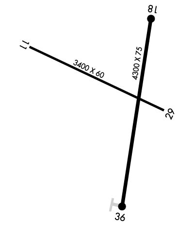
| Rwy | Rwy | |||||||
| 3400x60 | 3400' | 3400x60 | 3400' | |||||
| 4300x75 | 4300' | 4300x75 | 4300' | |||||
| Runway ID | Single Wheel | Double Wheel | Double Tandem Wheel | Dual Double Wheel |
| 11/29 | 30,000 | 30,000 | N/A | N/A |
| 18/36 | 30,000 | 30,000 | N/A | N/A |
| These numbers are Advisory and are not limits. The Airport Manager should have more accurate Weight Limits | ||||
 Airport Diagram might not be current. | |
| Facility Name: | KINGMAN/CLYDE CESSNA FLD |
| City Name: | KINGMAN |
| County: | KINGMAN |
| State abbrev: | KS |
| State Name: | KANSAS |
| Ownership: | PUBLICLY OWNED |
| Use: | OPEN TO THE PUBLIC |
| Owner's Name: | CITY OF KINGMAN |
| Address: | 324 NORTH MAIN |
| KINGMAN, KS 67068 | |
| Owner's Phone: | 620-532-3111 |
| Manager's Name: | TIM GULLION |
| Address: | PO BOX 262 |
| KINGMAN, KS 67068 | |
| Phone: | 620-532-1279 |
| FAA Region: | CENTRAL |
| FAA Field Office: | NONE |
| Date | Sunrise | Sunset |
|---|---|---|
| 05/13/26 Wednesday | 6:25 | 20:33 |
| 05/14/26 Thursday | 6:24 | 20:34 |
| 05/15/26 Friday | 6:23 | 20:35 |
| 05/16/26 Saturday | 6:22 | 20:36 |
| 05/17/26 Sunday | 6:21 | 20:37 |
| 05/18/26 Monday | 6:21 | 20:38 |
| 05/19/26 Tuesday | 6:20 | 20:38 |
| 05/20/26 Wednesday | 6:19 | 20:39 |
| 05/21/26 Thursday | 6:18 | 20:40 |
| 05/22/26 Friday | 6:18 | 20:41 |
| 05/23/26 Saturday | 6:17 | 20:42 |
| 05/24/26 Sunday | 6:16 | 20:42 |
| 05/25/26 Monday | 6:16 | 20:43 |
| 05/26/26 Tuesday | 6:15 | 20:44 |
| Airport Attendance Schedule | MON-FRI 0830-2000 |
| Airport Status | OPERATIONAL (This Status can change at any time - please check NOTAMS) |
| Airport Lighting Schedule | ACTVT REIL RWY 18 & 36; PAPI RWY 18 & 36; MIRL 18/36 - CTAF. |
| Airport Storage Available | Tie Downs, Hanger |
| Extra Services Available | Crop Dusting, Flight Instruction, Aircraft Rental |
| Wind Indicator | YES - (lighted) |
| Control Tower | NO |
| CTAF Frequency | 122.800 |
| Unicom Frequency | 122.800 |
| Rotating Beacon Color | WG |
| Segmented Circle | YES |
| Landing Fee | NO |
| Airport Inspected | STATE - performed by PRIVATE CONTRACT PERSONNEL |
| Inspection Date | 09/17/2024 |
| Type of Fuel Available | Grade 100LL; -10SELF SVC FUEL. |
| Airframe Repair Service | MAJOR |
| Power Plant Repair Service | MAJOR |
| Latitude | N3740.1 |
| Longitude | W09807.4 (ESTIMATED) |
| Arpt Elevation | 1606ft (SURVEYED) |
| Magnetic Variation | 06E |
| 1 miles NW | of KINGMAN |
| Traffic Pattern Altitude | |
| Sectional Chart | WICHITA |
| Operations (Reported) | Yearly | Avg. Daily |
|---|---|---|
| General Aviation Transient | 0 | 0 |
| General Aviation Local | 0 | 0 |
| Air Taxi | 0 | 0 |
| Commerical | 0 | 0 |
| Commuter | 0 | 0 |
| Military | 0 | 0 |
| Aircraft based on Field | |
|---|---|
| General Aviation Singles | 0 |
| General Aviation Multi | 0 |
| Jet Aircraft | 0 |
| General Aviation Helicopters | 0 |
| Military Aircraft | 0 |
| Gliders | 0 |
| Ultralights | 0 |
| FSS on field | NO |
| FSS tie-in | WICHITA |
| FSS Phone | 1-800-WX-BRIEF |
| Who issues Notams | ICT |
| Notam D service at airport | YES |
| ARTCC Name | KANSAS CITY |
| Airport Certification | |
| Aircraft Rescue & Firefighting Index | None |
| Airport of Entry | No |
| Custom Landing Rights | No |
| Joint Civil/Military | No |
| Military Landing rights | No |
| NATIONAL PLAN OF INTEGRATED AIRPORT SYSTEMS (NPIAS) |
| FOR CD CTC WICHITA APCH AT 316-350-1520. |
Airport Communications & Frequencies:
| ||||||||||||||
| Runway: 11 | Runway: 29 | ||
| Mag heading: | 110° | Mag heading: | 290° |
| Rwy Slope: | -.41% Down | Rwy Slope: | .41% Up |
| Approach: | Approach: | ||
| Pattern: | Left Traffic | Pattern: | Right Traffic |
| Markings: | BASIC | Markings: | BASIC |
| Marking Condition: | GOOD | Marking Condition: | GOOD |
| Arresting Dev: | Arresting Dev: | ||
| Lat & Long: | N3740.3 W09807.9 | Lat. & Long.: | N3740.1 W09807.2 |
| Elev: | 1606.6 ft. MSL | Elev: | 1592.5 ft. MSL |
| TCH: | TCH: | ||
| Visual Glide Path: | Visual Glide Path: | ||
| Displaced Threshold: | No | Displaced Threshold: | No |
| Touchdown Zone: | YES | Touchdown Zone: | YES |
| Touchdown Elev.: | 1606.6 feet | Touchdown Elev.: | 1606.0 feet |
| Visual Glide Slope: | Visual Glide Slope: | ||
| RVR Equipment: | RVR Equipment: | ||
| RVV Equipment: | NO | RVV Equipment: | NO |
| Approach Lights: | Approach Lights: | ||
| REIL: | NO | REIL: | NO |
| Centerline Lights: | NO | Centerline Lights: | NO |
| Touchdown lights: | NO | Touchdown lights: | NO |
| Runway Category: | Runway with a Visual Approach | Runway Category: | Runway with a Visual Approach |
| Declared Distances: | TORA:3400' TODA:3400' ASDA:3400' LDA:3400' | Declared Distances: | TORA:3400' TODA:3400' ASDA:3400' LDA:3400' |
| Obstructions: | TREES | Obstructions: | POWER LINE MARKED WITH ORANGE BALLS. |
| Marked: | NOT Marked/Lighted | Marked: | NOT Marked/Lighted |
| Clearance slope: | 31:1 | Clearance slope: | 20:1 |
| Obstruction height: | 37 feet AGL | Obstruction height: | |
| Dist. from runway: | 1362 feet | Dist. from runway: | |
| Centerline offset: | 365 right of centerline | Centerline offset: | |
| Comments: | Comments: |
| Runway: 18 | Runway: 36 | ||
| Mag heading: | 182° | Mag heading: | 2° |
| Rwy Slope: | -.05% Down | Rwy Slope: | .05% Up |
| Approach: | Approach: | ||
| Pattern: | Right Traffic | Pattern: | Left Traffic |
| Markings: | NONPRECISION INSTRUMENT | Markings: | NONPRECISION INSTRUMENT |
| Marking Condition: | GOOD | Marking Condition: | GOOD |
| Arresting Dev: | Arresting Dev: | ||
| Lat & Long: | N3740.4 W09807.3 | Lat. & Long.: | N3739.7 W09807.4 |
| Elev: | 1598.7 ft. MSL | Elev: | 1596.5 ft. MSL |
| TCH: | 43 ft. AGL | TCH: | 44 ft. AGL |
| Visual Glide Path: | 3.00 degrees | Visual Glide Path: | 3.00 degrees |
| Displaced Threshold: | No | Displaced Threshold: | No |
| Touchdown Zone: | YES | Touchdown Zone: | YES |
| Touchdown Elev.: | 1598.7 feet | Touchdown Elev.: | 1596.6 feet |
| Visual Glide Slope: | 2-Light PAPI on LEFT side of Runway | Visual Glide Slope: | 2-Light PAPI on LEFT side of Runway |
| RVR Equipment: | RVR Equipment: | ||
| RVV Equipment: | NO | RVV Equipment: | NO |
| Approach Lights: | Approach Lights: | ||
| REIL: | YES | REIL: | YES |
| Centerline Lights: | NO | Centerline Lights: | NO |
| Touchdown lights: | NO | Touchdown lights: | NO |
| Runway Category: | Runway with a Non-precision Approach having visibility minimums greater than 3/4 mile | Runway Category: | Runway with a Non-precision Approach having visibility minimums greater than 3/4 mile |
| Declared Distances: | TORA:4300' TODA:4300' ASDA:4300' LDA:4300' | Declared Distances: | TORA:4300' TODA:4300' ASDA:4300' LDA:4300' |
| Obstructions: | ROAD | Obstructions: | TREES |
| Marked: | NOT Marked/Lighted | Marked: | NOT Marked/Lighted |
| Clearance slope: | 24:1 | Clearance slope: | 24:1 |
| Obstruction height: | 15 feet AGL | Obstruction height: | 45 feet AGL |
| Dist. from runway: | 550 feet | Dist. from runway: | 1290 feet |
| Centerline offset: | Centerline offset: | ||
| Comments: | Comments: |
Thanks for using FltPlan.com
all rights reserved © 1999-2026 by Flight Plan LLC