| REIGLE FIELD PALMYRA PA |
| |
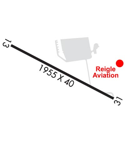
| Lat: N 4017.2 Long: W 07634.6 Elev: 489 Var: +10 Longest Runway: 1955 | ||
| CTAF: 122.8 | ||
| |||||||||||||||||||||||||||||||||||||||||||||||||||||||||||||
| |||||||||||||||||||||||||||||||||||||||||||||||||||||||||||||
| Rwy | Rwy | |||||||
| 1955x40 | 1955' | 1955x40 | 1655' | |||||
| Runway ID | Single Wheel | Double Wheel | Double Tandem Wheel | Dual Double Wheel |
| 13/31 | 12,500 | N/A | N/A | N/A |
| These numbers are Advisory and are not limits. The Airport Manager should have more accurate Weight Limits | ||||
 Airport Diagram might not be current. | |
| Facility Name: | REIGLE FLD |
| City Name: | PALMYRA |
| County: | LEBANON |
| State abbrev: | PA |
| State Name: | PENNSYLVANIA |
| Ownership: | PRIVATELY OWNED |
| Use: | OPEN TO THE PUBLIC |
| Owner's Name: | DUANE REIGLE/MICHELLE WOLF |
| Address: | 1805 S FORGE RD |
| PALMYRA, PA 17078 | |
| Owner's Phone: | 717-838-5519 |
| Manager's Name: | MICHELLE WOLF |
| Address: | 1805 S FORGE RD |
| PALMYRA, PA 17078 | |
| Phone: | 717-838-5519 |
| FAA Region: | EASTERN |
| FAA Field Office: | HAR |

| Date | Sunrise | Sunset |
|---|---|---|
| 09/24/21 Friday | 6:56 | 19:01 |
| 09/25/21 Saturday | 6:56 | 18:59 |
| 09/26/21 Sunday | 6:57 | 18:57 |
| 09/27/21 Monday | 6:58 | 18:56 |
| 09/28/21 Tuesday | 6:59 | 18:54 |
| 09/29/21 Wednesday | 7:00 | 18:52 |
| 09/30/21 Thursday | 7:01 | 18:51 |
| 10/01/21 Friday | 7:02 | 18:49 |
| 10/02/21 Saturday | 7:03 | 18:47 |
| 10/03/21 Sunday | 7:04 | 18:46 |
| 10/04/21 Monday | 7:05 | 18:44 |
| 10/05/21 Tuesday | 7:06 | 18:42 |
| 10/06/21 Wednesday | 7:07 | 18:41 |
| 10/07/21 Thursday | 7:08 | 18:39 |
| Airport Attendance Schedule | 7 Days A Week 0900-1700 |
| Airport Status | OPERATIONAL (This Status can change at any time - please check NOTAMS) |
| Airport Lighting Schedule | ACTVT LIRL RWY 13/31 - CTAF.; ACTVT ROTG BCN - CTAF. |
| Airport Storage Available | Tie Downs, Hanger |
| Extra Services Available | Flight Instruction, Aircraft Rental |
| Wind Indicator | YES - (unlit) |
| Control Tower | NO |
| CTAF Frequency | 122.800 |
| Unicom Frequency | 122.800 |
| Rotating Beacon Color | CLEAR-GREEN (Light Land Airport) |
| Segmented Circle | NO |
| Landing Fee |
| Airport Inspected | STATE - performed by STATE AERONAUTICAL PERSONNEL |
| Inspection Date | 03/11/2021 |
| Type of Fuel Available | Grade 100LL |
| Airframe Repair Service | MAJOR |
| Power Plant Repair Service | MAJOR |
| Latitude | N4017.2 |
| Longitude | W07634.6 (ESTIMATED) |
| Arpt Elevation | 489ft (SURVEYED) |
| Magnetic Variation | 10W |
| 2 miles S | of PALMYRA |
| Traffic Pattern Altitude | |
| Sectional Chart | NEW YORK |
| Operations (Reported) | Yearly | Avg. Daily |
|---|---|---|
| General Aviation Transient | 6000 | 16 |
| General Aviation Local | 24000 | 66 |
| Air Taxi | 0 | 0 |
| Commerical | 0 | 0 |
| Commuter | 0 | 0 |
| Military | 0 | 0 |
| Aircraft based on Field | |
|---|---|
| General Aviation Singles | 65 |
| General Aviation Multi | 0 |
| Jet Aircraft | 0 |
| General Aviation Helicopters | 0 |
| Military Aircraft | 0 |
| Gliders | 0 |
| Ultralights | 0 |
| FSS on field | NO |
| FSS tie-in | WILLIAMSPORT |
| FSS Phone | 1-800-WX-BRIEF |
| Who issues Notams | IPT |
| Notam D service at airport | YES |
| ARTCC Name | NEW YORK |
| Airport Certification | |
| Aircraft Rescue & Firefighting Index | None |
| Airport of Entry | No |
| Custom Landing Rights | No |
| Joint Civil/Military | No |
| Military Landing rights | No |
| FOR CD CTC HARRISBURG APCH AT 800-932-0712. |
| RWY 13/3 1 NSTD LIRL; LGTS LCTD 125 FT L AND R OF CNTRLN. RWY 13; FIRST 110 FT UNLGTD. RWY 31; FIRST 60 FT UNLGTD. 1780 FT OF RWY LGTD. |
Airport Communications & Frequencies:
| ||||||||||||||||||||||||||||||
| Runway: 13 | Runway: 31 | ||
| Mag heading: | 127° | Mag heading: | 307° |
| Rwy Slope: | .36% Up | Rwy Slope: | -.36% Down |
| Approach: | Approach: | ||
| Pattern: | Left Traffic | Pattern: | Left Traffic |
| Markings: | BASIC | Markings: | BASIC |
| Marking Condition: | FAIR | Marking Condition: | FAIR |
| Arresting Dev: | Arresting Dev: | ||
| Lat & Long: | N4017.3 W07634.8 | Lat. & Long.: | N4017.1 W07634.4 |
| Elev: | 482.0 ft. MSL | Elev: | 489.0 ft. MSL |
| TCH: | TCH: | ||
| Visual Glide Path: | Visual Glide Path: | ||
| Displaced Threshold: | No | Displaced Threshold: | 300 feet; DSPLCD THLD IDENTIFIED AT NIGHT BY ONE GREEN LGT EACH SIDE OF RWY. |
| Touchdown Zone: | YES | Touchdown Zone: | YES |
| Touchdown Elev.: | 489.0 feet | Touchdown Elev.: | 489.0 feet |
| Visual Glide Slope: | Visual Glide Slope: | ||
| RVR Equipment: | RVR Equipment: | ||
| RVV Equipment: | NO | RVV Equipment: | NO |
| Approach Lights: | Approach Lights: | ||
| REIL: | NO | REIL: | NO |
| Centerline Lights: | NO | Centerline Lights: | NO |
| Touchdown lights: | NO | Touchdown lights: | NO |
| Runway Category: | Runway with a Visual Approach | Runway Category: | Runway with a Visual Approach |
| Declared Distances: | Declared Distances: | ||
| Obstructions: | Obstructions: | BRUSH | |
| Marked: | Marked: | NOT Marked/Lighted | |
| Clearance slope: | 20:1 | Clearance slope: | 1:1; 20:1 TO DSPLCD THLD. |
| Obstruction height: | Obstruction height: | 9 feet AGL | |
| Dist. from runway: | Dist. from runway: | 208 feet | |
| Centerline offset: | Centerline offset: | 106 feet left of centerline | |
| Comments: | Comments: | +15 FT ROAD 25-60 FT FROM RWY. |
Thanks for using FltPlan.com
all rights reserved © 1999-2021 by Flight Plan LLC