
| PORTLAND-MULINO PORTLAND-MULINO OR |
| |
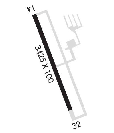
| Lat: N 4513.0 Long: W 12235.4 Elev: 260 Var: -19 Longest Runway: 3425 | ||
| Clr Del: 119.95 CTAF: 123.05 | ||
| ||||||||||||||||||||||||||||||||||||||||||||
| ||||||||||||||||||||||||||||||||||||||||||||
| Rwy | Rwy | |||||||
| 3425x100 | 3425' | 3425x100 | 3425' | |||||
| Runway ID | Single Wheel | Double Wheel | Double Tandem Wheel | Dual Double Wheel |
| 14/32 | N/A | N/A | N/A | N/A |
| These numbers are Advisory and are not limits. The Airport Manager should have more accurate Weight Limits | ||||
| FltPlan does not have IFR approach charts available for K4S9. |
 Airport Diagram might not be current. | |
| Facility Name: | MULINO STATE |
| City Name: | PORTLAND-MULINO |
| County: | CLACKAMAS |
| State abbrev: | OR |
| State Name: | OREGON |
| Ownership: | PUBLICLY OWNED |
| Use: | OPEN TO THE PUBLIC |
| Owner's Name: | OREGON DEPARTMENT OF AVIATION |
| Address: | 3040 25TH STREET SE |
| SALEM, OR 97302 | |
| Owner's Phone: | 503-378-4880 |
| Manager's Name: | OREGON DEPARTMENT OF AVIATION |
| Address: | 3040 25TH STREET SE |
| SALEM, OR 97302 | |
| Phone: | 503-378-4880 |
| FAA Region: | NORTHWEST MOUNTAIN |
| FAA Field Office: | SEA |
| Date | Sunrise | Sunset |
|---|---|---|
| 11/18/25 Tuesday | 7:13 | 16:38 |
| 11/19/25 Wednesday | 7:14 | 16:37 |
| 11/20/25 Thursday | 7:15 | 16:36 |
| 11/21/25 Friday | 7:17 | 16:36 |
| 11/22/25 Saturday | 7:18 | 16:35 |
| 11/23/25 Sunday | 7:19 | 16:34 |
| 11/24/25 Monday | 7:20 | 16:33 |
| 11/25/25 Tuesday | 7:22 | 16:33 |
| 11/26/25 Wednesday | 7:23 | 16:32 |
| 11/27/25 Thursday | 7:24 | 16:31 |
| 11/28/25 Friday | 7:25 | 16:31 |
| 11/29/25 Saturday | 7:27 | 16:30 |
| 11/30/25 Sunday | 7:28 | 16:30 |
| 12/01/25 Monday | 7:29 | 16:30 |
| Airport Attendance Schedule | UNATTENDED |
| Airport Status | OPERATIONAL (This Status can change at any time - please check NOTAMS) |
| Airport Lighting Schedule | ACTIVATE MIRL RY 14/32, TWY LGTS, & WINDCONE - CTAF. PAPI RYS 14 & 32 OPR 24 HRS. |
| Airport Storage Available | Tie Downs |
| Extra Services Available | Flight Instruction, Parachute Jumping, Aircraft Rental |
| Wind Indicator | YES - (lighted) |
| Control Tower | NO |
| CTAF Frequency | 123.050 |
| Unicom Frequency | 123.050 |
| Rotating Beacon Color | WG |
| Segmented Circle | YES |
| Landing Fee | NO |
| Airport Inspected | STATE - performed by STATE AERONAUTICAL PERSONNEL |
| Inspection Date | 09/12/2024 |
| Type of Fuel Available | Grade 100LL |
| Airframe Repair Service | MAJOR |
| Power Plant Repair Service | MAJOR |
| Latitude | N4513.0 |
| Longitude | W12235.4 (ESTIMATED) |
| Arpt Elevation | 259ft (SURVEYED) |
| Magnetic Variation | 19E |
| 20 miles S | of PORTLAND-MULINO |
| Traffic Pattern Altitude | |
| Sectional Chart | SEATTLE |
| Operations (Reported) | Yearly | Avg. Daily |
|---|---|---|
| General Aviation Transient | 0 | 0 |
| General Aviation Local | 0 | 0 |
| Air Taxi | 0 | 0 |
| Commerical | 0 | 0 |
| Commuter | 0 | 0 |
| Military | 0 | 0 |
| Aircraft based on Field | |
|---|---|
| General Aviation Singles | 0 |
| General Aviation Multi | 0 |
| Jet Aircraft | 0 |
| General Aviation Helicopters | 0 |
| Military Aircraft | 0 |
| Gliders | 0 |
| Ultralights | 0 |
| FSS on field | NO |
| FSS tie-in | MC MINNVILLE |
| FSS Phone | 1-800-WX-BRIEF |
| Who issues Notams | MMV |
| Notam D service at airport | YES |
| ARTCC Name | SEATTLE |
| Airport Certification | |
| Aircraft Rescue & Firefighting Index | None |
| Airport of Entry | No |
| Custom Landing Rights | No |
| Joint Civil/Military | No |
| Military Landing rights | No |
| NATIONAL PLAN OF INTEGRATED AIRPORT SYSTEMS (NPIAS) |
| GRANT AGREEMENTS UNDER FAAP/ADAP/AIP |
| ASSURANCES PURSUANT TO TITLE VI, CIVIL RIGHTS ACT OF 1964 |
| RY 32 DESIGNATED CALM WIND RY. |
| WILDLIFE ON & INVOF OF ARPT. |
| BE ALERT FOR WEEKEND GLIDER ACTIVITY. |
| SKYDIVING ACTIVITY ON AND IN VICINITY OF AIRPORT. LANDING ZONE 1400' EAST OF RUNWAY. |
| FOR CD CTC PORTLAND APCH AT 503-493-7545. |
Airport Communications & Frequencies:
|
| Runway: 14 | Runway: 32 | ||
| Mag heading: | 140° | Mag heading: | 321° |
| Rwy Slope: | .35% Up | Rwy Slope: | -.35% Down |
| Approach: | Approach: | ||
| Pattern: | Right Traffic | Pattern: | Left Traffic |
| Markings: | BASIC | Markings: | BASIC |
| Marking Condition: | GOOD | Marking Condition: | GOOD |
| Arresting Dev: | Arresting Dev: | ||
| Lat & Long: | N4513.3 W12235.6 | Lat. & Long.: | N4512.7 W12235.3 |
| Elev: | 247.8 ft. MSL | Elev: | 259.9 ft. MSL |
| TCH: | 43 ft. AGL | TCH: | 33 ft. AGL |
| Visual Glide Path: | 3.00 degrees | Visual Glide Path: | 3.00 degrees |
| Displaced Threshold: | No | Displaced Threshold: | No |
| Touchdown Zone: | YES | Touchdown Zone: | YES |
| Touchdown Elev.: | 258.4 feet | Touchdown Elev.: | 259.9 feet |
| Visual Glide Slope: | 2-Light PAPI on LEFT side of Runway | Visual Glide Slope: | 2-Light PAPI on LEFT side of Runway; PAPI OTS INDEF. |
| RVR Equipment: | RVR Equipment: | ||
| RVV Equipment: | NO | RVV Equipment: | NO |
| Approach Lights: | Approach Lights: | ||
| REIL: | NO | REIL: | NO |
| Centerline Lights: | NO | Centerline Lights: | NO |
| Touchdown lights: | NO | Touchdown lights: | NO |
| Runway Category: | Runway with a Visual Approach | Runway Category: | Runway with a Visual Approach |
| Declared Distances: | Declared Distances: | ||
| Obstructions: | TREE | Obstructions: | TREES |
| Marked: | NOT Marked/Lighted | Marked: | NOT Marked/Lighted |
| Clearance slope: | 10:1 | Clearance slope: | 13:1 |
| Obstruction height: | 77 feet AGL | Obstruction height: | 212 feet AGL |
| Dist. from runway: | 1002 feet | Dist. from runway: | 3059 feet |
| Centerline offset: | 194 right of centerline | Centerline offset: | 138 feet right of centerline |
| Comments: | Comments: |
Thanks for using FltPlan.com
all rights reserved © 1999-2025 by Flight Plan LLC
