| SCOTTSBORO MUNI-WORD FIELD SCOTTSBORO AL |
| |
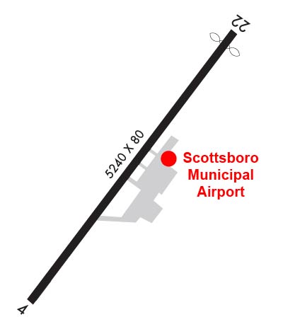
| Lat: N 3441.3 Long: W 08600.4 Elev: 650 Var: +03 Longest Runway: 5240 | ||
| AWOS: 120.12 CTAF: 123.0 | ||
| |||||||||||||||||||||||
| |||||||||||||||||||||||
| |||||||||||||||||||||||
| Rwy | Rwy | |||||||
| 5240x80 | 5240' | 5240x80 | 5010' | |||||
| Runway ID | Single Wheel | Double Wheel | Double Tandem Wheel | Dual Double Wheel |
| 04/22 | 15,000 | N/A | N/A | N/A |
| These numbers are Advisory and are not limits. The Airport Manager should have more accurate Weight Limits | ||||
 Airport Diagram might not be current. | |
| Facility Name: | SCOTTSBORO MUNI-WORD FLD |
| City Name: | SCOTTSBORO |
| County: | JACKSON |
| State abbrev: | AL |
| State Name: | ALABAMA |
| Ownership: | PUBLICLY OWNED |
| Use: | OPEN TO THE PUBLIC |
| Owner's Name: | CITY OF SCOTTSBORO |
| Address: | 316 BROAD ST |
| SCOTTSBORO, AL 35768 | |
| Owner's Phone: | 256-574-3100 |
| Manager's Name: | JB SANDLIN |
| Address: | 86 AVIATION CIRCLE |
| SCOTTSBORO, AL 35768 | |
| Phone: | 256-259-3702; CELL: 913-226-7806 |
| FAA Region: | SOUTHERN |
| FAA Field Office: | JAN |
| Date | Sunrise | Sunset |
|---|---|---|
| 09/24/21 Friday | 6:33 | 18:38 |
| 09/25/21 Saturday | 6:34 | 18:37 |
| 09/26/21 Sunday | 6:35 | 18:35 |
| 09/27/21 Monday | 6:36 | 18:34 |
| 09/28/21 Tuesday | 6:36 | 18:33 |
| 09/29/21 Wednesday | 6:37 | 18:31 |
| 09/30/21 Thursday | 6:38 | 18:30 |
| 10/01/21 Friday | 6:38 | 18:28 |
| 10/02/21 Saturday | 6:39 | 18:27 |
| 10/03/21 Sunday | 6:40 | 18:26 |
| 10/04/21 Monday | 6:41 | 18:24 |
| 10/05/21 Tuesday | 6:42 | 18:23 |
| 10/06/21 Wednesday | 6:42 | 18:21 |
| 10/07/21 Thursday | 6:43 | 18:20 |
| Airport Attendance Schedule | 7 Days A Week 0800-1700; CLOSED ON CHRISTMAS. |
| Airport Status | OPERATIONAL (This Status can change at any time - please check NOTAMS) |
| Airport Lighting Schedule | MIRL RWY 04/22 PRESET LOW INTST; TO INCR INTST ACTVT- CTAF. TO ACTVT REIL RWY 04 & 22 - CTAF. PAPI RWY 04 & 22 OPR CONSLY. |
| Airport Storage Available | Tie Downs |
| Extra Services Available | Flight Instruction |
| Wind Indicator | YES - (lighted) |
| Control Tower | NO |
| CTAF Frequency | 123.000 |
| Unicom Frequency | 123.000 |
| Rotating Beacon Color | CLEAR-GREEN (Light Land Airport) |
| Segmented Circle | NO |
| Landing Fee | NO |
| Airport Inspected | STATE - performed by STATE AERONAUTICAL PERSONNEL |
| Inspection Date | 02/08/2021 |
| Type of Fuel Available | Grade 100LL, JET A (freeze point -40C) |
| Airframe Repair Service | MAJOR |
| Power Plant Repair Service | MAJOR; REPAIRS AVBL ON CALL 256-259-3702. |
| Latitude | N3441.3 |
| Longitude | W08600.4 (ESTIMATED) |
| Arpt Elevation | 650ft (SURVEYED) |
| Magnetic Variation | 03W |
| 2 miles NE | of SCOTTSBORO |
| Traffic Pattern Altitude | 800 |
| Sectional Chart | ATLANTA |
| Operations (Reported) | Yearly | Avg. Daily |
|---|---|---|
| General Aviation Transient | 6296 | 17 |
| General Aviation Local | 1449 | 4 |
| Air Taxi | 0 | 0 |
| Commerical | 0 | 0 |
| Commuter | 0 | 0 |
| Military | 0 | 0 |
| Aircraft based on Field | |
|---|---|
| General Aviation Singles | 21 |
| General Aviation Multi | 2 |
| Jet Aircraft | 0 |
| General Aviation Helicopters | 0 |
| Military Aircraft | 0 |
| Gliders | 0 |
| Ultralights | 0 |
| FSS on field | NO |
| FSS tie-in | ANNISTON |
| FSS Phone | 1-800-WX-BRIEF |
| Who issues Notams | ANB |
| Notam D service at airport | YES |
| ARTCC Name | ATLANTA |
| Airport Certification | |
| Aircraft Rescue & Firefighting Index | None |
| Airport of Entry | No |
| Custom Landing Rights | No |
| Joint Civil/Military | No |
| Military Landing rights | No |
| NATIONAL PLAN OF INTEGRATED AIRPORT SYSTEMS (NPIAS) |
| GRANT AGREEMENTS UNDER FAAP/ADAP/AIP |
| ASSURANCES PURSUANT TO TITLE VI, CIVIL RIGHTS ACT OF 1964 |
| RED LGTD TV TWR 1 MILE SW. |
| TWY LGTS FOR TWY TURNOFF ONLY. |
| FOR CD CTC ATLANTA ARTCC AT 770-210-7692. |
Airport Communications & Frequencies:
| |||||||||
| Runway: 04 | Runway: 22 | ||
| Mag heading: | 40° | Mag heading: | 220° |
| Rwy Slope: | -.38% Down | Rwy Slope: | .38% Up |
| Approach: | Approach: | ||
| Pattern: | Right Traffic | Pattern: | Left Traffic |
| Markings: | NONPRECISION INSTRUMENT | Markings: | NONPRECISION INSTRUMENT |
| Marking Condition: | GOOD | Marking Condition: | GOOD |
| Arresting Dev: | Arresting Dev: | ||
| Lat & Long: | N3441.0 W08600.7 | Lat. & Long.: | N3441.7 W08600.0 |
| Elev: | 650.3 ft. MSL | Elev: | 630.2 ft. MSL |
| TCH: | 25 ft. AGL | TCH: | 40 ft. AGL |
| Visual Glide Path: | 3.00 degrees | Visual Glide Path: | 3.00 degrees |
| Displaced Threshold: | No | Displaced Threshold: | 230 feet; RWY 22 LGTD THRS DSPLCD FOR NGT OPNS. |
| Touchdown Zone: | YES | Touchdown Zone: | YES |
| Touchdown Elev.: | 650.3 feet | Touchdown Elev.: | 640.5 feet |
| Visual Glide Slope: | 4-Light PAPI on LEFT side of Runway; OTS INDEFLY. | Visual Glide Slope: | 4-Light PAPI on LEFT side of Runway |
| RVR Equipment: | RVR Equipment: | ||
| RVV Equipment: | NO | RVV Equipment: | NO |
| Approach Lights: | Approach Lights: | ||
| REIL: | YES | REIL: | YES |
| Centerline Lights: | NO | Centerline Lights: | NO |
| Touchdown lights: | NO | Touchdown lights: | NO |
| Runway Category: | Runway with a Non-precision Approach having visibility minimums greater than 3/4 mile | Runway Category: | Runway with a Non-precision Approach having visibility minimums greater than 3/4 mile |
| Declared Distances: | Declared Distances: | ||
| Obstructions: | TREES | Obstructions: | TREES |
| Marked: | NOT Marked/Lighted | Marked: | NOT Marked/Lighted |
| Clearance slope: | 22:1 | Clearance slope: | 7:1; APCH SLOPE 20:1 FM DSPLCD THR. |
| Obstruction height: | 83 feet AGL | Obstruction height: | 85 feet AGL |
| Dist. from runway: | 2044 feet | Dist. from runway: | 842 feet |
| Centerline offset: | 81 right of centerline | Centerline offset: | 280 feet right of centerline |
| Comments: | Comments: |
Thanks for using FltPlan.com
all rights reserved © 1999-2021 by Flight Plan LLC