
| HAWTHORNE FIELD KOUNTZE/SILSBEE TX |
| |
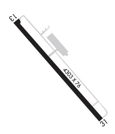
| Lat: N 3020.2 Long: W 09415.5 Elev: 71 Var: -04 Longest Runway: 4303 | ||
| CTAF: 122.8 | ||
| ||||||||||||||||||||||||||||||||||||||||||||
| ||||||||||||||||||||||||||||||||||||||||||||
| Rwy | Rwy | |||||||
| 4303x76 | 4303' | 4303x76 | 4303' | |||||
| Runway ID | Single Wheel | Double Wheel | Double Tandem Wheel | Dual Double Wheel |
| 13/31 | 12,500 | N/A | N/A | N/A |
| These numbers are Advisory and are not limits. The Airport Manager should have more accurate Weight Limits | ||||
 Airport Diagram might not be current. | |
| Facility Name: | HAWTHORNE FLD |
| City Name: | KOUNTZE/SILSBEE |
| County: | HARDIN |
| State abbrev: | TX |
| State Name: | TEXAS |
| Ownership: | PUBLICLY OWNED |
| Use: | OPEN TO THE PUBLIC |
| Owner's Name: | HARDIN COUNTY |
| Address: | PO BOX 760 |
| KOUNTZE, TX 77625 | |
| Owner's Phone: | 409-246-5120 |
| Manager's Name: | DALE WILLIFORD |
| Address: | PO BOX 502 |
| KOUNTZE, TX 77625 | |
| Phone: | (409) 782-7620 |
| FAA Region: | SOUTHWEST |
| FAA Field Office: | TEX |
| Date | Sunrise | Sunset |
|---|---|---|
| 08/26/25 Tuesday | 6:50 | 19:47 |
| 08/27/25 Wednesday | 6:51 | 19:46 |
| 08/28/25 Thursday | 6:51 | 19:45 |
| 08/29/25 Friday | 6:52 | 19:44 |
| 08/30/25 Saturday | 6:52 | 19:42 |
| 08/31/25 Sunday | 6:53 | 19:41 |
| 09/01/25 Monday | 6:54 | 19:40 |
| 09/02/25 Tuesday | 6:54 | 19:39 |
| 09/03/25 Wednesday | 6:55 | 19:38 |
| 09/04/25 Thursday | 6:55 | 19:36 |
| 09/05/25 Friday | 6:56 | 19:35 |
| 09/06/25 Saturday | 6:56 | 19:34 |
| 09/07/25 Sunday | 6:57 | 19:33 |
| 09/08/25 Monday | 6:57 | 19:31 |
| Airport Attendance Schedule | 7 Days A Week 0800-1730 |
| Airport Status | OPERATIONAL (This Status can change at any time - please check NOTAMS) |
| Airport Lighting Schedule | MIRL RY 13/31 PRESET LOW INTST DUSK-DAWN; TO INCR INTST ACTVT - CTAF. |
| Airport Storage Available | Tie Downs |
| Extra Services Available | Flight Instruction, Aircraft Rental |
| Wind Indicator | YES - (lighted) |
| Control Tower | NO |
| CTAF Frequency | 122.800 |
| Unicom Frequency | 122.800 |
| Rotating Beacon Color | WG |
| Segmented Circle | YES |
| Landing Fee | NO |
| Airport Inspected | STATE - performed by PRIVATE CONTRACT PERSONNEL |
| Inspection Date | 04/03/2023 |
| Type of Fuel Available | Grade 100LL, JET A (freeze point -40C); -1024 HR SELF SERVE FUEL. |
| Airframe Repair Service | None |
| Power Plant Repair Service | None |
| Latitude | N3020.2 |
| Longitude | W09415.5 (ESTIMATED) |
| Arpt Elevation | 70ft (SURVEYED) |
| Magnetic Variation | 04E |
| 3 miles SE | of KOUNTZE/SILSBEE |
| Traffic Pattern Altitude | |
| Sectional Chart | HOUSTON |
| Operations (Reported) | Yearly | Avg. Daily |
|---|---|---|
| General Aviation Transient | 0 | 0 |
| General Aviation Local | 0 | 0 |
| Air Taxi | 0 | 0 |
| Commerical | 0 | 0 |
| Commuter | 0 | 0 |
| Military | 0 | 0 |
| Aircraft based on Field | |
|---|---|
| General Aviation Singles | 0 |
| General Aviation Multi | 0 |
| Jet Aircraft | 0 |
| General Aviation Helicopters | 0 |
| Military Aircraft | 0 |
| Gliders | 0 |
| Ultralights | 0 |
| FSS on field | NO |
| FSS tie-in | MONTGOMERY COUNTY |
| FSS Phone | 1-800-WX-BRIEF |
| Who issues Notams | CXO |
| Notam D service at airport | YES |
| ARTCC Name | HOUSTON |
| Airport Certification | |
| Aircraft Rescue & Firefighting Index | None |
| Airport of Entry | No |
| Custom Landing Rights | No |
| Joint Civil/Military | No |
| Military Landing rights | YES |
| NATIONAL PLAN OF INTEGRATED AIRPORT SYSTEMS (NPIAS) |
| GRANT AGREEMENTS UNDER FAAP/ADAP/AIP |
| ASSURANCES PURSUANT TO TITLE VI, CIVIL RIGHTS ACT OF 1964 |
| OBLIGATIONS ASSUMED BY TRANSFER |
| FOR CD CTC HOUSTON APCH AT 281-443-5844 TO CNL IFR CALL 281-443-5888. |
Airport Communications & Frequencies:
| ||||||||||||||
| Runway: 13 | Runway: 31 | ||
| Mag heading: | 136° | Mag heading: | 316° |
| Rwy Slope: | -.08% Down | Rwy Slope: | .08% Up |
| Approach: | Approach: | ||
| Pattern: | Left Traffic | Pattern: | Left Traffic |
| Markings: | NONPRECISION INSTRUMENT | Markings: | NONPRECISION INSTRUMENT |
| Marking Condition: | POOR; RY & TWY MKGS INCLUDING HOLD LINES FADED. | Marking Condition: | POOR |
| Arresting Dev: | Arresting Dev: | ||
| Lat & Long: | N3020.5 W09415.7 | Lat. & Long.: | N3019.9 W09415.2 |
| Elev: | 68.7 ft. MSL | Elev: | 65.4 ft. MSL |
| TCH: | 29 ft. AGL | TCH: | 31 ft. AGL |
| Visual Glide Path: | 3.00 degrees | Visual Glide Path: | 4.00 degrees |
| Displaced Threshold: | No | Displaced Threshold: | No |
| Touchdown Zone: | YES | Touchdown Zone: | YES |
| Touchdown Elev.: | 70.8 feet | Touchdown Elev.: | 69.7 feet |
| Visual Glide Slope: | 2-Light PAPI on LEFT side of Runway | Visual Glide Slope: | 2-Light PAPI on LEFT side of Runway; PAPI OTS |
| RVR Equipment: | RVR Equipment: | ||
| RVV Equipment: | NO | RVV Equipment: | NO |
| Approach Lights: | Approach Lights: | ||
| REIL: | NO | REIL: | NO |
| Centerline Lights: | NO | Centerline Lights: | NO |
| Touchdown lights: | NO | Touchdown lights: | NO |
| Runway Category: | Runway with a Non-precision Approach | Runway Category: | Runway with a Visual Approach |
| Declared Distances: | Declared Distances: | ||
| Obstructions: | TREE | Obstructions: | TREE |
| Marked: | NOT Marked/Lighted | Marked: | NOT Marked/Lighted |
| Clearance slope: | 17:1 | Clearance slope: | 11:1 |
| Obstruction height: | 90 feet AGL | Obstruction height: | 65 feet AGL |
| Dist. from runway: | 1736 feet | Dist. from runway: | 935 feet |
| Centerline offset: | 380 right of centerline | Centerline offset: | 270B |
| Comments: | Comments: |
Thanks for using FltPlan.com
all rights reserved © 1999-2025 by Flight Plan LLC
