
| CALICO ROCK-IZARD COUNTY CALICO ROCK AR |
| |
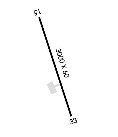
| Lat: N 3609.9 Long: W 09208.7 Elev: 733 Var: -03 Longest Runway: 3000 | ||
| CTAF: 122.9 | ||
| ||||||||||||||||||||||||||||||||
| ||||||||||||||||||||||||||||||||
| Rwy | Rwy | |||||||
| 3000x60 | 3000' | 3000x60 | 3000' | |||||
| Runway ID | Single Wheel | Double Wheel | Double Tandem Wheel | Dual Double Wheel |
| 15/33 | 12,500 | N/A | N/A | N/A |
| These numbers are Advisory and are not limits. The Airport Manager should have more accurate Weight Limits | ||||
| FltPlan does not have IFR approach charts available for K37T. |
 Airport Diagram might not be current. | |
| Facility Name: | CALICO ROCK-IZARD COUNTY |
| City Name: | CALICO ROCK |
| County: | IZARD |
| State abbrev: | AR |
| State Name: | ARKANSAS |
| Ownership: | PUBLICLY OWNED |
| Use: | OPEN TO THE PUBLIC |
| Owner's Name: | STATE DEPT OF CORRECTIONS |
| Address: | #10 PRISON CIRCLE |
| CALICO ROCK, AR 72519 | |
| Owner's Phone: | 870-297-4311 |
| Manager's Name: | DR. JOHN LANE |
| Address: | P.O. BOX 216 |
| CALICO ROCK, AR 72519 | |
| Phone: | (870) 291-1200 |
| FAA Region: | SOUTHWEST |
| FAA Field Office: | AOK |
| Date | Sunrise | Sunset |
|---|---|---|
| 09/24/21 Friday | 6:58 | 19:03 |
| 09/25/21 Saturday | 6:59 | 19:01 |
| 09/26/21 Sunday | 6:59 | 19:00 |
| 09/27/21 Monday | 7:00 | 18:58 |
| 09/28/21 Tuesday | 7:01 | 18:57 |
| 09/29/21 Wednesday | 7:02 | 18:55 |
| 09/30/21 Thursday | 7:03 | 18:54 |
| 10/01/21 Friday | 7:03 | 18:52 |
| 10/02/21 Saturday | 7:04 | 18:51 |
| 10/03/21 Sunday | 7:05 | 18:50 |
| 10/04/21 Monday | 7:06 | 18:48 |
| 10/05/21 Tuesday | 7:07 | 18:47 |
| 10/06/21 Wednesday | 7:08 | 18:45 |
| 10/07/21 Thursday | 7:08 | 18:44 |
| Airport Attendance Schedule | UNATTENDED |
| Airport Status | OPERATIONAL (This Status can change at any time - please check NOTAMS) |
| Airport Lighting Schedule | ACTVT REIL, PAPI & MIRL RWY 15/33 - CTAF. |
| Airport Storage Available | Tie Downs |
| Extra Services Available | NONE |
| Wind Indicator | YES - (lighted) |
| Control Tower | NO |
| CTAF Frequency | 122.900 |
| Unicom Frequency | |
| Rotating Beacon Color | |
| Segmented Circle | NO |
| Landing Fee |
| Airport Inspected | STATE - performed by STATE AERONAUTICAL PERSONNEL |
| Inspection Date | 04/04/2019 |
| Type of Fuel Available | None |
| Airframe Repair Service | None |
| Power Plant Repair Service | None |
| Latitude | N3609.9 |
| Longitude | W09208.7 (ESTIMATED) |
| Arpt Elevation | 733ft (ESTIMATED) |
| Magnetic Variation | 03E |
| 3 miles NW | of CALICO ROCK |
| Traffic Pattern Altitude | |
| Sectional Chart | KANSAS CITY |
| Operations (Reported) | Yearly | Avg. Daily |
|---|---|---|
| General Aviation Transient | 1500 | 4 |
| General Aviation Local | 1600 | 4 |
| Air Taxi | 0 | 0 |
| Commerical | 0 | 0 |
| Commuter | 0 | 0 |
| Military | 20 | 0 |
| Aircraft based on Field | |
|---|---|
| General Aviation Singles | 10 |
| General Aviation Multi | 0 |
| Jet Aircraft | 0 |
| General Aviation Helicopters | 0 |
| Military Aircraft | 0 |
| Gliders | 0 |
| Ultralights | 0 |
| FSS on field | NO |
| FSS tie-in | JONESBORO |
| FSS Phone | 1-800-WX-BRIEF |
| Who issues Notams | JBR |
| Notam D service at airport | YES |
| ARTCC Name | MEMPHIS |
| Airport Certification | |
| Aircraft Rescue & Firefighting Index | None |
| Airport of Entry | No |
| Custom Landing Rights | No |
| Joint Civil/Military | No |
| Military Landing rights | No |
| NATIONAL PLAN OF INTEGRATED AIRPORT SYSTEMS (NPIAS) |
| FOR CD CTC MEMPHIS ARTCC AT 901-368-8453/8449. |
| Runway: 15 | Runway: 33 | ||
| Mag heading: | N/A | Mag heading: | N/A |
| Rwy Slope: | -1.23% Down | Rwy Slope: | 1.23% Up |
| Approach: | Approach: | ||
| Pattern: | Left Traffic | Pattern: | Left Traffic |
| Markings: | BASIC | Markings: | BASIC |
| Marking Condition: | FAIR | Marking Condition: | FAIR |
| Arresting Dev: | Arresting Dev: | ||
| Lat & Long: | N3610.2 W09208.9 | Lat. & Long.: | N3609.7 W09208.6 |
| Elev: | 733.0 ft. MSL | Elev: | 696.0 ft. MSL |
| TCH: | 29 ft. AGL | TCH: | 29 ft. AGL |
| Visual Glide Path: | 4.00 degrees | Visual Glide Path: | 4.00 degrees |
| Displaced Threshold: | No | Displaced Threshold: | No |
| Touchdown Zone: | NO | Touchdown Zone: | NO |
| Touchdown Elev.: | Touchdown Elev.: | ||
| Visual Glide Slope: | 2-Light PAPI on LEFT side of Runway | Visual Glide Slope: | 2-Light PAPI on LEFT side of Runway |
| RVR Equipment: | RVR Equipment: | ||
| RVV Equipment: | NO | RVV Equipment: | NO |
| Approach Lights: | Approach Lights: | ||
| REIL: | YES | REIL: | YES |
| Centerline Lights: | NO | Centerline Lights: | NO |
| Touchdown lights: | NO | Touchdown lights: | NO |
| Runway Category: | Runway with a Visual Approach | Runway Category: | Runway with a Visual Approach |
| Declared Distances: | Declared Distances: | ||
| Obstructions: | Obstructions: | TREES | |
| Marked: | Marked: | NOT Marked/Lighted | |
| Clearance slope: | 50:1 | Clearance slope: | 22:1 |
| Obstruction height: | Obstruction height: | 33 feet AGL | |
| Dist. from runway: | Dist. from runway: | 930 feet | |
| Centerline offset: | Centerline offset: | 180 feet right of centerline | |
| Comments: | Comments: |
Thanks for using FltPlan.com
all rights reserved © 1999-2021 by Flight Plan LLC
