
| CHARLES W. BAKER MILLINGTON TN |
| |
| Lat: N 3516.7 Long: W 08956.0 Elev: 247 Var: +01 Longest Runway: 3499 | ||
| AWOS: 122.8 CTAF: 122.8 | ||
| ||||||||||||||||||||||||||||||||||||||||||||
| ||||||||||||||||||||||||||||||||||||||||||||
| ||||||||||||||||||||||||||||||||||||||||||||
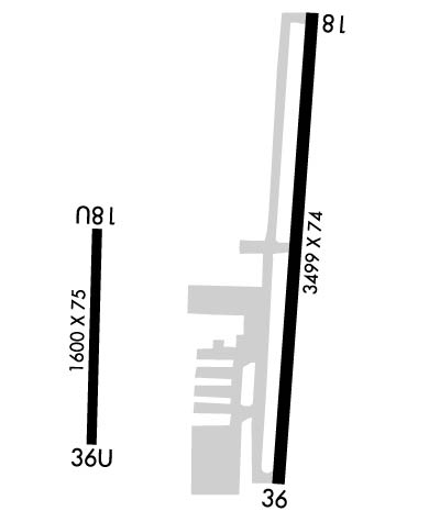
| Rwy | Rwy | |||||||
| 3499x75 | 3499' | 3499x75 | 3499' | |||||
| 1600x75 | 1600' | 1600x75 | 1600' | |||||
| Runway ID | Single Wheel | Double Wheel | Double Tandem Wheel | Dual Double Wheel |
| 18/36 | 25,000 | N/A | N/A | N/A |
| 18U/36U | 4,000 | N/A | N/A | N/A |
| These numbers are Advisory and are not limits. The Airport Manager should have more accurate Weight Limits | ||||
 Airport Diagram might not be current. | |
| Facility Name: | CHARLES W BAKER |
| City Name: | MILLINGTON |
| County: | SHELBY |
| State abbrev: | TN |
| State Name: | TENNESSEE |
| Ownership: | PUBLICLY OWNED |
| Use: | OPEN TO THE PUBLIC |
| Owner's Name: | MEMPHIS SHELBY CO ARPT AUTH |
| Address: | 2491 WINCHESTER ROAD, SUITE 113 |
| MEMPHIS, TN 38116-3856 | |
| Owner's Phone: | 901-922-8000 |
| Manager's Name: | JASON MCBRIDE |
| Address: | 2787 NORTH SECOND STREET |
| MEMPHIS, TN 38127 | |
| Phone: | 901-358-0028 |
| FAA Region: | SOUTHERN |
| FAA Field Office: | MEM |
| Date | Sunrise | Sunset |
|---|---|---|
| 03/12/26 Thursday | 7:15 | 19:05 |
| 03/13/26 Friday | 7:14 | 19:06 |
| 03/14/26 Saturday | 7:12 | 19:06 |
| 03/15/26 Sunday | 7:11 | 19:07 |
| 03/16/26 Monday | 7:09 | 19:08 |
| 03/17/26 Tuesday | 7:08 | 19:09 |
| 03/18/26 Wednesday | 7:07 | 19:10 |
| 03/19/26 Thursday | 7:05 | 19:11 |
| 03/20/26 Friday | 7:04 | 19:11 |
| 03/21/26 Saturday | 7:02 | 19:12 |
| 03/22/26 Sunday | 7:01 | 19:13 |
| 03/23/26 Monday | 7:00 | 19:14 |
| 03/24/26 Tuesday | 6:58 | 19:15 |
| 03/25/26 Wednesday | 6:57 | 19:15 |
| Airport Attendance Schedule | WED-SAT 0700-1700; UNATNDD THANKSGIVING & CHRISTMAS. |
| Airport Status | OPERATIONAL (This Status can change at any time - please check NOTAMS) |
| Airport Lighting Schedule | SS-SR |
| Airport Storage Available | Tie Downs |
| Extra Services Available | NONE |
| Wind Indicator | YES - (lighted) |
| Control Tower | NO |
| CTAF Frequency | 122.800 |
| Unicom Frequency | 122.800 |
| Rotating Beacon Color | WG |
| Segmented Circle | YES |
| Landing Fee | NO |
| Airport Inspected | STATE - performed by STATE AERONAUTICAL PERSONNEL |
| Inspection Date | 04/12/2023 |
| Type of Fuel Available | Grade 100LL, JET A |
| Airframe Repair Service | None |
| Power Plant Repair Service | None |
| Latitude | N3516.7 |
| Longitude | W08956.0 (ESTIMATED) |
| Arpt Elevation | 246ft (SURVEYED) |
| Magnetic Variation | 01W |
| 4 miles SW | of MILLINGTON |
| Traffic Pattern Altitude | |
| Sectional Chart | MEMPHIS |
| Operations (Reported) | Yearly | Avg. Daily |
|---|---|---|
| General Aviation Transient | 0 | 0 |
| General Aviation Local | 0 | 0 |
| Air Taxi | 0 | 0 |
| Commerical | 0 | 0 |
| Commuter | 0 | 0 |
| Military | 0 | 0 |
| Aircraft based on Field | |
|---|---|
| General Aviation Singles | 0 |
| General Aviation Multi | 0 |
| Jet Aircraft | 0 |
| General Aviation Helicopters | 0 |
| Military Aircraft | 0 |
| Gliders | 0 |
| Ultralights | 0 |
| FSS on field | NO |
| FSS tie-in | JACKSON |
| FSS Phone | 1-800-WX-BRIEF |
| Who issues Notams | MKL |
| Notam D service at airport | YES |
| ARTCC Name | MEMPHIS |
| Airport Certification | |
| Aircraft Rescue & Firefighting Index | None |
| Airport of Entry | No |
| Custom Landing Rights | No |
| Joint Civil/Military | No |
| Military Landing rights | YES |
| NATIONAL PLAN OF INTEGRATED AIRPORT SYSTEMS (NPIAS) |
| GRANT AGREEMENTS UNDER FAAP/ADAP/AIP |
| SURPLUS PROPERTY AGREEMENT UNDER PUBLIC LAW 289 |
| ASSURANCES PURSUANT TO TITLE VI, CIVIL RIGHTS ACT OF 1964 |
| FIXED WING GRASS AREA TKOF OR LNDG NA. |
| FOR CD CTC MEMPHIS APCH AT 901-842-8457. |
| RWY 18U/ 36UCLSD INDEF. |
Airport Communications & Frequencies:
| ||||||||||||||
| Runway: 18 | Runway: 36 | ||
| Mag heading: | 185° | Mag heading: | 5° |
| Rwy Slope: | -.13% Down | Rwy Slope: | .13% Up |
| Approach: | Approach: | ||
| Pattern: | Left Traffic | Pattern: | Right Traffic |
| Markings: | NONPRECISION INSTRUMENT | Markings: | NONPRECISION INSTRUMENT |
| Marking Condition: | FAIR | Marking Condition: | FAIR |
| Arresting Dev: | Arresting Dev: | ||
| Lat & Long: | N3517.0 W08955.9 | Lat. & Long.: | N3516.5 W08955.9 |
| Elev: | 246.8 ft. MSL | Elev: | 242.3 ft. MSL |
| TCH: | 40 ft. AGL | TCH: | 40 ft. AGL |
| Visual Glide Path: | 4.00 degrees | Visual Glide Path: | 4.00 degrees |
| Displaced Threshold: | No | Displaced Threshold: | No |
| Touchdown Zone: | YES | Touchdown Zone: | YES |
| Touchdown Elev.: | 246.8 feet | Touchdown Elev.: | 246.2 feet |
| Visual Glide Slope: | 2-Light PAPI on LEFT side of Runway | Visual Glide Slope: | 2-Light PAPI on LEFT side of Runway |
| RVR Equipment: | RVR Equipment: | ||
| RVV Equipment: | NO | RVV Equipment: | NO |
| Approach Lights: | Approach Lights: | ||
| REIL: | YES | REIL: | YES |
| Centerline Lights: | NO | Centerline Lights: | NO |
| Touchdown lights: | NO | Touchdown lights: | NO |
| Runway Category: | Runway with a Non-precision Approach | Runway Category: | Runway with a Non-precision Approach |
| Declared Distances: | Declared Distances: | ||
| Obstructions: | TREE | Obstructions: | TREE |
| Marked: | NOT Marked/Lighted | Marked: | NOT Marked/Lighted |
| Clearance slope: | 15:1 | Clearance slope: | 16:1 |
| Obstruction height: | 76 feet AGL | Obstruction height: | 45 feet AGL |
| Dist. from runway: | 1378 feet | Dist. from runway: | 956 feet |
| Centerline offset: | 1376 right of centerline | Centerline offset: | 955 feet right of centerline |
| Comments: | Comments: |
| Runway: 18U | Runway: 36U | ||
| Mag heading: | 183° | Mag heading: | 3° |
| Rwy Slope: | .06% Up | Rwy Slope: | -.06% Down |
| Approach: | Approach: | ||
| Pattern: | Left Traffic | Pattern: | Left Traffic |
| Markings: | NONSTANDARD | Markings: | NONSTANDARD |
| Marking Condition: | POOR | Marking Condition: | POOR |
| Arresting Dev: | Arresting Dev: | ||
| Lat & Long: | N3516.8 W08956.2 | Lat. & Long.: | N3516.5 W08956.2 |
| Elev: | 240.0 ft. MSL | Elev: | 241.0 ft. MSL |
| TCH: | TCH: | ||
| Visual Glide Path: | Visual Glide Path: | ||
| Displaced Threshold: | No | Displaced Threshold: | No |
| Touchdown Zone: | NO | Touchdown Zone: | NO |
| Touchdown Elev.: | Touchdown Elev.: | ||
| Visual Glide Slope: | Visual Glide Slope: | ||
| RVR Equipment: | RVR Equipment: | ||
| RVV Equipment: | NO | RVV Equipment: | NO |
| Approach Lights: | Approach Lights: | ||
| REIL: | NO | REIL: | NO |
| Centerline Lights: | NO | Centerline Lights: | NO |
| Touchdown lights: | NO | Touchdown lights: | NO |
| Runway Category: | Runway with a Visual Approach | Runway Category: | Runway with a Visual Approach |
| Declared Distances: | Declared Distances: | ||
| Obstructions: | TREE | Obstructions: | TREES |
| Marked: | NOT Marked/Lighted | Marked: | NOT Marked/Lighted; PLINE 970 FT FM RWY END; MKD WITH ORANGE BALLS. |
| Clearance slope: | 9:1 | Clearance slope: | 13:1 |
| Obstruction height: | 30 feet AGL | Obstruction height: | 96 feet AGL |
| Dist. from runway: | 475 feet | Dist. from runway: | 1500 feet |
| Centerline offset: | 87 right of centerline | Centerline offset: | 217 feet left of centerline |
| Comments: | Comments: |
Thanks for using FltPlan.com
all rights reserved © 1999-2026 by Flight Plan LLC
