
| ELYRIA ELYRIA OH |
| |
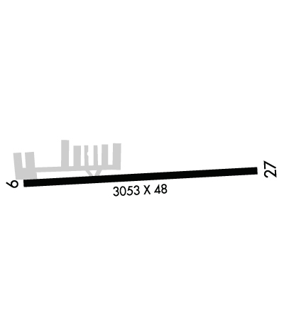
| Lat: N 4119.9 Long: W 08206.0 Elev: 758 Var: +06 Longest Runway: 3053 | ||
| Clr Del: 125.7 CTAF: 122.8 | ||
| ||||||
|
| Rwy | Rwy | |||||||
| 3053x48 | 3053' | 3053x48 | 3053' | |||||
| Runway ID | Single Wheel | Double Wheel | Double Tandem Wheel | Dual Double Wheel |
| 09/27 | N/A | N/A | N/A | N/A |
| These numbers are Advisory and are not limits. The Airport Manager should have more accurate Weight Limits | ||||
 Airport Diagram might not be current. | |
| Facility Name: | ELYRIA |
| City Name: | ELYRIA |
| County: | LORAIN |
| State abbrev: | OH |
| State Name: | OHIO |
| Ownership: | PRIVATELY OWNED |
| Use: | OPEN TO THE PUBLIC |
| Owner's Name: | ELYRIA AIRPORT LIMITED |
| Address: | 3593 MEDINA RD #319 |
| MEDINA, OH 44256-8182 | |
| Owner's Phone: | 440-343-4943 |
| Manager's Name: | ANGELO GOUSIOS |
| Address: | 3593 MEDINA RD #319; ARPT PHYS ADS: 10875 MIDDLE AVE, ELYRIA, OH 44035-7802. |
| MEDINA, OH 44256-8182 | |
| Phone: | 440-343-4943; OR 440-458-4215. |
| FAA Region: | GREAT LAKES |
| FAA Field Office: | DET |
| Date | Sunrise | Sunset |
|---|---|---|
| 01/17/26 Saturday | 7:51 | 17:26 |
| 01/18/26 Sunday | 7:51 | 17:27 |
| 01/19/26 Monday | 7:50 | 17:29 |
| 01/20/26 Tuesday | 7:50 | 17:30 |
| 01/21/26 Wednesday | 7:49 | 17:31 |
| 01/22/26 Thursday | 7:48 | 17:32 |
| 01/23/26 Friday | 7:48 | 17:33 |
| 01/24/26 Saturday | 7:47 | 17:35 |
| 01/25/26 Sunday | 7:46 | 17:36 |
| 01/26/26 Monday | 7:45 | 17:37 |
| 01/27/26 Tuesday | 7:45 | 17:38 |
| 01/28/26 Wednesday | 7:44 | 17:40 |
| 01/29/26 Thursday | 7:43 | 17:41 |
| 01/30/26 Friday | 7:42 | 17:42 |
| Airport Attendance Schedule | MON-FRI 0800-1700; UNATNDD MAJOR HOLS. |
| Airport Status | OPERATIONAL (This Status can change at any time - please check NOTAMS) |
| Airport Lighting Schedule | SS-SR |
| Airport Storage Available | NONE |
| Extra Services Available | Avionics |
| Wind Indicator | YES - (unlit) |
| Control Tower | NO |
| CTAF Frequency | 122.800 |
| Unicom Frequency | 122.800 |
| Rotating Beacon Color | WG |
| Segmented Circle | NO |
| Landing Fee | NO |
| Airport Inspected | STATE - performed by STATE AERONAUTICAL PERSONNEL |
| Inspection Date | 10/10/2024 |
| Type of Fuel Available | Grade 100LL; -10FUEL AVBL H24 VIA CREDIT CARD. |
| Airframe Repair Service | MAJOR |
| Power Plant Repair Service | MAJOR |
| Latitude | N4119.9 |
| Longitude | W08206.0 (ESTIMATED) |
| Arpt Elevation | 757ft (SURVEYED) |
| Magnetic Variation | 06W |
| 2 miles S | of ELYRIA |
| Traffic Pattern Altitude | |
| Sectional Chart | DETROIT |
| Operations (Reported) | Yearly | Avg. Daily |
|---|---|---|
| General Aviation Transient | 0 | 0 |
| General Aviation Local | 0 | 0 |
| Air Taxi | 0 | 0 |
| Commerical | 0 | 0 |
| Commuter | 0 | 0 |
| Military | 0 | 0 |
| Aircraft based on Field | |
|---|---|
| General Aviation Singles | 0 |
| General Aviation Multi | 0 |
| Jet Aircraft | 0 |
| General Aviation Helicopters | 0 |
| Military Aircraft | 0 |
| Gliders | 0 |
| Ultralights | 0 |
| FSS on field | NO |
| FSS tie-in | CLEVELAND |
| FSS Phone | 1-800-WX-BRIEF |
| Who issues Notams | CLE |
| Notam D service at airport | YES |
| ARTCC Name | CLEVELAND |
| Airport Certification | |
| Aircraft Rescue & Firefighting Index | None |
| Airport of Entry | No |
| Custom Landing Rights | No |
| Joint Civil/Military | No |
| Military Landing rights | No |
| THIS AIRPORT HAS BEEN SURVEYED BY THE NATIONAL GEODETIC SURVEY. |
| DEER & BIRDS ON & INVOF ARPT. |
| FOR CD CTC CLEVELAND APCH AT 216-352-2323. |
| RWY 09/2 7 NSTD LIRL DUE TO 18 INCH NON-FRANGIBLE MOUNTING STAKES. |
Airport Communications & Frequencies:
| ||||||||||||||||
| Runway: 09 | Runway: 27 | ||
| Mag heading: | 91° | Mag heading: | 271° |
| Rwy Slope: | .06% Up | Rwy Slope: | -.06% Down |
| Approach: | Approach: | ||
| Pattern: | Left Traffic | Pattern: | Left Traffic |
| Markings: | BASIC | Markings: | BASIC |
| Marking Condition: | GOOD | Marking Condition: | GOOD |
| Arresting Dev: | Arresting Dev: | ||
| Lat & Long: | N4119.9 W08206.3 | Lat. & Long.: | N4119.9 W08205.7 |
| Elev: | 755.7 ft. MSL | Elev: | 757.6 ft. MSL |
| TCH: | TCH: | ||
| Visual Glide Path: | Visual Glide Path: | ||
| Displaced Threshold: | No | Displaced Threshold: | No |
| Touchdown Zone: | YES | Touchdown Zone: | YES |
| Touchdown Elev.: | 757.8 feet | Touchdown Elev.: | 757.8 feet |
| Visual Glide Slope: | Visual Glide Slope: | ||
| RVR Equipment: | RVR Equipment: | ||
| RVV Equipment: | NO | RVV Equipment: | NO |
| Approach Lights: | Approach Lights: | ||
| REIL: | NO | REIL: | NO |
| Centerline Lights: | NO | Centerline Lights: | NO |
| Touchdown lights: | NO | Touchdown lights: | NO |
| Runway Category: | Runway with a Visual Approach | Runway Category: | Runway with a Visual Approach |
| Declared Distances: | Declared Distances: | ||
| Obstructions: | TREE | Obstructions: | TREE |
| Marked: | NOT Marked/Lighted | Marked: | NOT Marked/Lighted |
| Clearance slope: | Clearance slope: | ||
| Obstruction height: | 85 feet AGL | Obstruction height: | 85 feet AGL |
| Dist. from runway: | 201 feet | Dist. from runway: | 201 feet |
| Centerline offset: | 105 right of centerline | Centerline offset: | 125 feet left of centerline |
| Comments: | 10 FT BRUSH & 70 FT TREES, 100-199 FT DIST, 102 FT R. | Comments: |
Thanks for using FltPlan.com
all rights reserved © 1999-2026 by Flight Plan LLC
