
| DALLAS BAY SKY PARK CHATTANOOGA TN |
| |
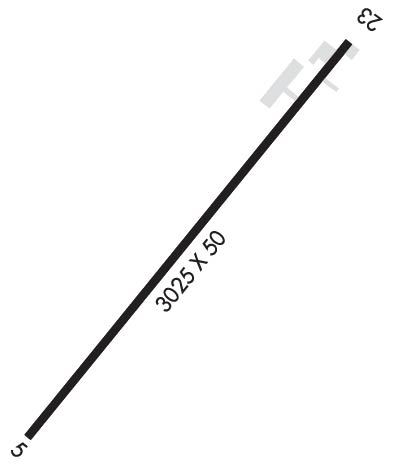
| Lat: N 3511.3 Long: W 08510.7 Elev: 690 Var: +02 Longest Runway: 3025 | ||
| CTAF: 123.0 | ||
| ||||||
|
| Rwy | Rwy | |||||||
| 3025x50 | 2825' | 3025x50 | 2325' | |||||
| Runway ID | Single Wheel | Double Wheel | Double Tandem Wheel | Dual Double Wheel |
| 05/23 | N/A | N/A | N/A | N/A |
| These numbers are Advisory and are not limits. The Airport Manager should have more accurate Weight Limits | ||||
| FltPlan does not have IFR approach charts available for K1A0. |
 Airport Diagram might not be current. | |
| Facility Name: | DALLAS BAY SKY PARK |
| City Name: | CHATTANOOGA |
| County: | HAMILTON |
| State abbrev: | TN |
| State Name: | TENNESSEE |
| Ownership: | PRIVATELY OWNED |
| Use: | OPEN TO THE PUBLIC |
| Owner's Name: | AVIATION INTEGRATED RESOURCE INC. |
| Address: | 1824 EAST CRABTREE RD. |
| HIXSON, TN 37343 | |
| Owner's Phone: | 423-842-9845 |
| Manager's Name: | CHRISTINE LEWIS |
| Address: | 1824 EAST CRABTREE RD. |
| HIXSON, TN 37343 | |
| Phone: | 423-322-0521 |
| FAA Region: | SOUTHERN |
| FAA Field Office: | MEM |

| Date | Sunrise | Sunset |
|---|---|---|
| 07/16/21 Friday | 6:38 | 20:55 |
| 07/17/21 Saturday | 6:39 | 20:55 |
| 07/18/21 Sunday | 6:39 | 20:54 |
| 07/19/21 Monday | 6:40 | 20:54 |
| 07/20/21 Tuesday | 6:41 | 20:53 |
| 07/21/21 Wednesday | 6:41 | 20:52 |
| 07/22/21 Thursday | 6:42 | 20:52 |
| 07/23/21 Friday | 6:43 | 20:51 |
| 07/24/21 Saturday | 6:44 | 20:50 |
| 07/25/21 Sunday | 6:44 | 20:50 |
| 07/26/21 Monday | 6:45 | 20:49 |
| 07/27/21 Tuesday | 6:46 | 20:48 |
| 07/28/21 Wednesday | 6:46 | 20:47 |
| 07/29/21 Thursday | 6:47 | 20:47 |
| Airport Attendance Schedule | SUN 1300-1800, MON-FRI IREG, SAT 0900-1800 |
| Airport Status | OPERATIONAL (This Status can change at any time - please check NOTAMS) |
| Airport Lighting Schedule | ACTVT LIRL RWY 05/23 - CTAF.; ROTG BCN ACTVTD WITH LIRL - CTAF. |
| Airport Storage Available | Tie Downs, Hanger |
| Extra Services Available | Flight Instruction, Aircraft Rental |
| Wind Indicator | YES - (unlit) |
| Control Tower | NO |
| CTAF Frequency | 123.000 |
| Unicom Frequency | 123.000 |
| Rotating Beacon Color | CLEAR-GREEN (Light Land Airport) |
| Segmented Circle | NO |
| Landing Fee | NO |
| Airport Inspected | STATE - performed by STATE AERONAUTICAL PERSONNEL |
| Inspection Date | 05/15/2020 |
| Type of Fuel Available | Grade 100LL |
| Airframe Repair Service | NONE |
| Power Plant Repair Service | NONE |
| Latitude | N3511.3 |
| Longitude | W08510.7 (ESTIMATED) |
| Arpt Elevation | 690ft (ESTIMATED) |
| Magnetic Variation | 02W |
| 11 miles N | of CHATTANOOGA |
| Traffic Pattern Altitude | |
| Sectional Chart | ATLANTA |
| Operations (Reported) | Yearly | Avg. Daily |
|---|---|---|
| General Aviation Transient | 225 | 1 |
| General Aviation Local | 5460 | 15 |
| Air Taxi | 0 | 0 |
| Commerical | 0 | 0 |
| Commuter | 0 | 0 |
| Military | 100 | 0 |
| Aircraft based on Field | |
|---|---|
| General Aviation Singles | 37 |
| General Aviation Multi | 2 |
| Jet Aircraft | 0 |
| General Aviation Helicopters | 1 |
| Military Aircraft | 0 |
| Gliders | 0 |
| Ultralights | 0 |
| FSS on field | NO |
| FSS tie-in | NASHVILLE |
| FSS Phone | 1-800-WX-BRIEF |
| Who issues Notams | BNA |
| Notam D service at airport | YES |
| ARTCC Name | ATLANTA |
| Airport Certification | |
| Aircraft Rescue & Firefighting Index | None |
| Airport of Entry | No |
| Custom Landing Rights | No |
| Joint Civil/Military | No |
| Military Landing rights | No |
| FOR CD CTC CHATTANOOGA APCH AT 423-855-6478, WHEN APCH CLSD CTC ATLANTA ARTCC AT 770-210-7692. |
| RWY 05/2 3 TREES BOTH SIDES OF RWY VIOLATE 7:1 TRANSITION SFC. BLDG BOTH SIDES OF RWY N END PENETRATE PRI SFC. |
| Runway: 05 | Runway: 23 | ||
| Mag heading: | N/A | Mag heading: | N/A |
| Approach: | Approach: | ||
| Pattern: | Left Traffic | Pattern: | Right Traffic |
| Markings: | BASIC | Markings: | BASIC |
| Marking Condition: | FAIR | Marking Condition: | FAIR |
| Arresting Dev: | Arresting Dev: | ||
| Lat & Long: | Lat. & Long.: | ||
| Elev: | N/A | Elev: | N/A |
| TCH: | TCH: | ||
| Visual Glide Path: | Visual Glide Path: | ||
| Displaced Threshold: | 200 feet | Displaced Threshold: | 700 feet |
| Touchdown Zone: | NO | Touchdown Zone: | NO |
| Touchdown Elev.: | Touchdown Elev.: | ||
| Visual Glide Slope: | Visual Glide Slope: | ||
| RVR Equipment: | RVR Equipment: | ||
| RVV Equipment: | NO | RVV Equipment: | NO |
| Approach Lights: | Approach Lights: | ||
| REIL: | NO | REIL: | NO |
| Centerline Lights: | NO | Centerline Lights: | NO |
| Touchdown lights: | NO | Touchdown lights: | NO |
| Runway Category: | Runway with a Visual Approach | Runway Category: | Runway with a Visual Approach |
| Declared Distances: | Declared Distances: | ||
| Obstructions: | TREE | Obstructions: | TREES |
| Marked: | NOT Marked/Lighted | Marked: | NOT Marked/Lighted |
| Clearance slope: | 4:1; APCH RATIO 9:1 TO DSPLCD THR. | Clearance slope: | 4:1; APCH RATIO 15:1 TO DSPLCD THR. |
| Obstruction height: | 77 feet AGL | Obstruction height: | 86 feet AGL |
| Dist. from runway: | 548 feet | Dist. from runway: | 611 feet |
| Centerline offset: | 84 left of centerline | Centerline offset: | 193 feet right of centerline |
| Comments: | Comments: |
Thanks for using FltPlan.com
all rights reserved © 1999-2021 by Flight Plan LLC